ATL: ARTHUR - Post-Tropical - Discussion
Moderator: S2k Moderators
-
JonathanBelles
- Professional-Met

- Posts: 11430
- Age: 35
- Joined: Sat Dec 24, 2005 9:00 pm
- Location: School: Florida State University (Tallahassee, FL) Home: St. Petersburg, Florida
- Contact:
-
TheAustinMan

- Category 5

- Posts: 1060
- Joined: Mon Jul 08, 2013 4:26 pm
- Location: Central TX / United States
Extended the radar loop that I posted earlier to better illustrate the elongating and weakening old-LLC and show the new circulation becoming dominant further out of Florida and near the Bahamas.

0 likes
Treat my opinions with a grain of salt. For official information see your local weather service.
“It's tough to make predictions, especially about the future.”
“It's tough to make predictions, especially about the future.”


Re: ATL: INVEST 91L - Discussion
multiple vortices all revolving around each other like most of the day, does look like it may be trying to form up further towards the Bahamas, but it's hard to tell by looking at radar at that distance.
0 likes
Ginger-(eye),Dennis,Diana,Kate,Gloria,Charley-(eye),Allison,Arthur,Bertha,Fran,Josephine,Bonnie,Earl,Dennis-(twice),Floyd, Isabel-(eye),Charley,Ophelia-(eyewall),Ernesto,Barry,Hanna,Irene-(eye),Arthur-(eye), Florence, Dorian, and countless depressions, storms, and nor'easters.
Re: ATL: INVEST 91L - Discussion
Love it. Twelve hour cycles of calling it dead, then turning around and lambasting NHC because it isn't named yet.
D-max is going to light this sucker up.
Overall trend looks good. Average motion is as forecast. Nothing has changed. I think this system is just getting started. I'm not expecting a major, but I think a named storm at some point this week is almost certain.
The posts in this forum are NOT official forecast and should not be used as such. They are just the opinion of the poster and may or may not be backed by sound meteorological data. They are NOT endorsed by any professional institution or storm2k.org. For official information, please refer to the NHC and NWS products.
0 likes

Re:
wyq614 wrote:Showers and thunderstorms are developing at night hours in Central Cuba and seems expanding, which I think is a little odd. Does this have something to do with 91L?
Not at all related, just some typical convergence going on between the north and south coasts of Cuba, it happens here some times in central FL to where it sometimes happens near or just after sunset.
0 likes
-
ozonepete
- Professional-Met
- Posts: 4743
- Joined: Mon Sep 07, 2009 3:23 pm
- Location: From Ozone Park, NYC / Now in Brooklyn, NY
Re:
wyq614 wrote:Showers and thunderstorms are developing at night hours in Central Cuba and seems expanding, which I think is a little odd. Does this have something to do with 91L?
I noticed that too. It's really hard to say exactly why, but it's a pretty good bet that this disturbance contributed to it. Possibly the westerly flow over the island around the bottom of our low pressure inhibited the daily sea breeze which causes their afternoon thunderstorms and then as this low has consolidated a little more this evening the westerly winds pulled back a little and the sea breeze popped some storms just before the sun went down. There's some upper level divergence over the island (look at CIMSS charts) which may have allowed the late blooming convection to grow upward into full thunderstorms.
0 likes
-
ozonepete
- Professional-Met
- Posts: 4743
- Joined: Mon Sep 07, 2009 3:23 pm
- Location: From Ozone Park, NYC / Now in Brooklyn, NY
Re: ATL: INVEST 91L - Discussion
Nice blowup apparently right over the center, even though there's still shear on the northern side. Starting to look pretty decent. I'm also quite sure this has stopped going south and is either beginning to move N or NW, or will be shortly, albeit very slowly.
0 likes
-
MGC

- S2K Supporter

- Posts: 5940
- Joined: Sun Mar 23, 2003 9:05 pm
- Location: Pass Christian MS, or what is left.
Re: ATL: INVEST 91L - Discussion
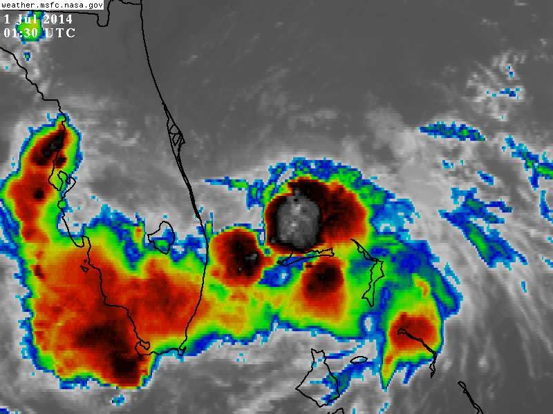
Looks to me, based on the shortwave IR loop, that the center is near the large blowup of convection just north of Grand Bahama Island. Don't look to be moving all that fast based on long range radar out of Melbourne. Doubt the NHC upgrades at 11pm. Convection is a bit lacking.....MGC
Above is the opinion of MGC and not an official forecast.
Above is the opinion of MGC and not an official forecast.
0 likes
-
ozonepete
- Professional-Met
- Posts: 4743
- Joined: Mon Sep 07, 2009 3:23 pm
- Location: From Ozone Park, NYC / Now in Brooklyn, NY
Re: ATL: INVEST 91L - Discussion
MGC wrote:Looks to me, based on the shortwave IR loop, that the center is near the large blowup of convection just north of Grand Bahama Island. Don't look to be moving all that fast based on long range radar out of Melbourne. Doubt the NHC upgrades at 11pm. Convection is a bit lacking.....MGC
Above is the opinion of MGC and not an official forecast.
Hi MGC. I doubt it too. They have time. It's a small storm and since the western side has subsidence and less severity and the Bahamas will improve as this starts moving northward, they can afford to wait.
0 likes
-
northjaxpro

- S2K Supporter
- Posts: 8900
- Joined: Mon Sep 27, 2010 11:21 am
- Location: Jacksonville, FL
Re: ATL: INVEST 91L - Discussion
ozonepete wrote:Nice blowup apparently right over the center, even though there's still shear on the northern side. Starting to look pretty decent. I'm also quite sure this has stopped going south and is either beginning to move N or NW, or will be shortly, albeit very slowly.
I wouldn't be surprised if it has stalled and stay in the general vicinity is in now for he next 12-24 hours and remaining well off shore the FL East Coast. It doesn't appear that 91L will get any closer to the FL coast than where it is now.
0 likes
NEVER, EVER SAY NEVER in the tropics and weather in general, and most importantly, with life itself!!
________________________________________________________________________________________
Fay 2008 Beryl 2012 Debby 2012 Colin 2016 Hermine 2016 Julia 2016 Matthew 2016 Irma 2017 Dorian 2019
________________________________________________________________________________________
Fay 2008 Beryl 2012 Debby 2012 Colin 2016 Hermine 2016 Julia 2016 Matthew 2016 Irma 2017 Dorian 2019
-
HurricaneTracker2031
- Tropical Storm

- Posts: 248
- Age: 26
- Joined: Fri Jul 19, 2013 7:20 pm
- Location: Pembroke Pines, FL, USA
- Contact:
Re: ATL: INVEST 91L - Discussion
Interesting burst near llc... a TD by 11pm est? What you all think 
Analysis for 91L and other Basins: http://goo.gl/lpp6pi
Personal Forecast Disclaimer:
The posts in this forum are NOT official forecast and should not be used as such. They are just the opinion of the poster and may or may not be backed by sound meteorological data. They are NOT endorsed by any professional institution or storm2k.org. For official information, please refer to the NHC and NWS products.
0 likes
SHORT VERSION OF DISCLAIMER: THIS SITE LINK BELOW IS NOT AN OFFICIAL FORECASTING OFFICE AND SHOULD NOT BE USED TO MAKE ANY EMERGENCY DECISIONS....
http://www.macstropicalweather.weebly.com
http://www.macstropicalweather.weebly.com
-
cycloneye

- Admin

- Posts: 149563
- Age: 69
- Joined: Thu Oct 10, 2002 10:54 am
- Location: San Juan, Puerto Rico
Re: ATL: INVEST 91L - Discussion
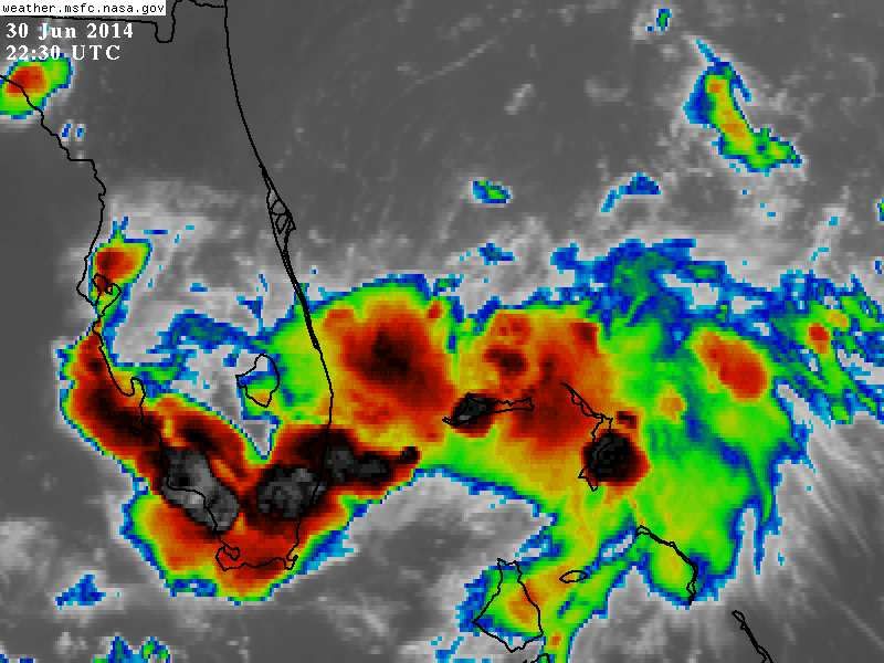
Very good graphic of where is the main low. Is under convection.

0 likes
Visit the Caribbean-Central America Weather Thread where you can find at first post web cams,radars
and observations from Caribbean basin members Click Here
and observations from Caribbean basin members Click Here
-
northjaxpro
- S2K Supporter
- Posts: 8900
- Joined: Mon Sep 27, 2010 11:21 am
- Location: Jacksonville, FL
Re: ATL: INVEST 91L - Discussion
HurricaneTracker2031 wrote:Interesting burst near llc... a TD by 11pm est? What you all think
Analysis for 91L and other Basins: http://goo.gl/lpp6pi
Personal Forecast Disclaimer:
The posts in this forum are NOT official forecast and should not be used as such. They are just the opinion of the poster and may or may not be backed by sound meteorological data. They are NOT endorsed by any professional institution or storm2k.org. For official information, please refer to the NHC and NWS products.
If the convective burst around the LLC holds together for a few hours, then I think NHC will pull the trigger and initiate advisories, probably as early as 2 a.m., but definitely by 5 a.m.
0 likes
NEVER, EVER SAY NEVER in the tropics and weather in general, and most importantly, with life itself!!
________________________________________________________________________________________
Fay 2008 Beryl 2012 Debby 2012 Colin 2016 Hermine 2016 Julia 2016 Matthew 2016 Irma 2017 Dorian 2019
________________________________________________________________________________________
Fay 2008 Beryl 2012 Debby 2012 Colin 2016 Hermine 2016 Julia 2016 Matthew 2016 Irma 2017 Dorian 2019
-
TheStormExpert
Re: ATL: INVEST 91L - Discussion
northjaxpro wrote:HurricaneTracker2031 wrote:Interesting burst near llc... a TD by 11pm est? What you all think
Analysis for 91L and other Basins: http://goo.gl/lpp6pi
Personal Forecast Disclaimer:
The posts in this forum are NOT official forecast and should not be used as such. They are just the opinion of the poster and may or may not be backed by sound meteorological data. They are NOT endorsed by any professional institution or storm2k.org. For official information, please refer to the NHC and NWS products.
If the convective burst around the LLC holds together for a few hours, then I think NHC will pull the trigger and initiate advisories, probably as early as 2 a.m., but definitely by 5 a.m.
Very unlikely at 2am since that's basically an Intermidiate Advisory. I remember a few years back on here hearing that the NHC more often initiates advisories at either 5am or 11pm?
0 likes
-
TheStormExpert
Interesting that 91L just disappeared off of the Storm2K map above.
EDIT: Looks like we have TD #1 as of 11pm June 30th. Wonder if the NHC just wanted to squeeze it out to end off June?
Anyways my original thoughts from earlier today of potentially seeing TD #1 by 11pm were correct.
EDIT: Looks like we have TD #1 as of 11pm June 30th. Wonder if the NHC just wanted to squeeze it out to end off June?
Anyways my original thoughts from earlier today of potentially seeing TD #1 by 11pm were correct.
Last edited by TheStormExpert on Mon Jun 30, 2014 10:01 pm, edited 1 time in total.
0 likes
-
TheAustinMan
- Category 5
- Posts: 1060
- Joined: Mon Jul 08, 2013 4:26 pm
- Location: Central TX / United States
It doesn't surprise me all too much that TD 1 has been classified given the latest developments. We'll see where NHC puts the center.
0 likes
Treat my opinions with a grain of salt. For official information see your local weather service.
“It's tough to make predictions, especially about the future.”
“It's tough to make predictions, especially about the future.”
-
hurricanefloyd5

- Category 5
- Posts: 1659
- Age: 45
- Joined: Sun May 02, 2004 10:53 am
- Location: Spartanburg
- Contact:
Who is online
Users browsing this forum: No registered users and 18 guests