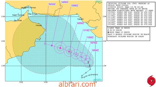
Grifforzer wrote:Considering numerical weather prediction models, GFS continues to show cyclonic storm with west northwestward movement towards moan coast till 0000 UTC, Saturday and then recurves towards northeast and weakening of the system over sea. ECMWF, Meteo France and UKMO models indicate maximum intensification up to depression/deep depression during the next 72 hours with north westward movement and weakening of the system thereafter. JMA model shows initial northwestward movement up to 60 hours and then westward movement with gradual intensification up to severe cyclonic storm during the 72 hours. Hence, there is a large variation in the track and intensity prediction by the models.
Looks like JMA does better job than IMD in this basin.