#147 Postby cycloneye » Sat May 24, 2014 9:38 am
Forecast to be a major cane
BULLETIN
HURRICANE AMANDA ADVISORY NUMBER 8
NWS NATIONAL HURRICANE CENTER MIAMI FL EP012014
800 AM PDT SAT MAY 24 2014
...AMANDA INTENSIFIES RAPIDLY AND BECOMES THE FIRST HURRICANE OF THE
EASTERN PACIFIC SEASON...
SUMMARY OF 800 AM PDT...1500 UTC...INFORMATION
----------------------------------------------
LOCATION...11.4N 109.9W
ABOUT 645 MI...1035 KM SW OF MANZANILLO MEXICO
MAXIMUM SUSTAINED WINDS...75 MPH...120 KM/H
PRESENT MOVEMENT...WNW OR 295 DEGREES AT 5 MPH...7 KM/H
MINIMUM CENTRAL PRESSURE...989 MB...29.21 INCHES
WATCHES AND WARNINGS
--------------------
THERE ARE NO COASTAL WATCHES OR WARNINGS IN EFFECT.
DISCUSSION AND 48-HOUR OUTLOOK
------------------------------
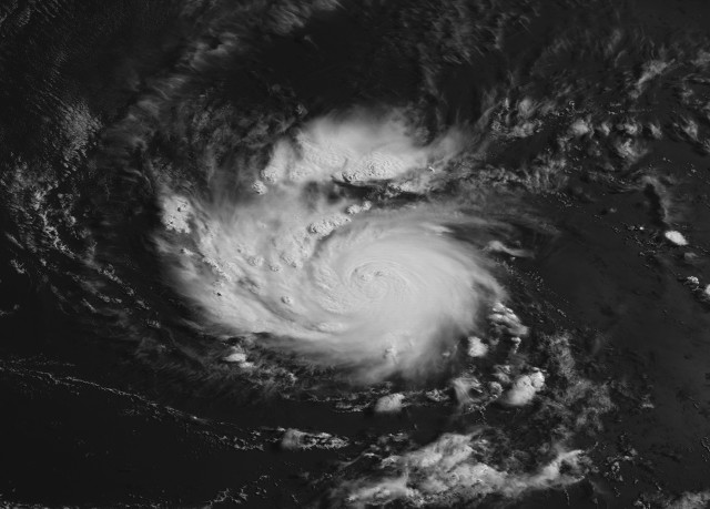
AT 800 AM PDT...1500 UTC...THE EYE OF HURRICANE AMANDA WAS LOCATED
NEAR LATITUDE 11.4 NORTH...LONGITUDE 109.9 WEST. AMANDA IS MOVING
TOWARD THE WEST-NORTHWEST NEAR 5 MPH...7 KM/H. A TURN TOWARD THE
NORTHWEST WITH A SLIGHT DECREASE IN FORWARD SPEED IS EXPECTED BY
EARLY SUNDAY...FOLLOWED BY A TURN TOWARD THE NORTH BY EARLY MONDAY.
AMANDA IS STRENGTHENING RAPIDLY...AND MAXIMUM SUSTAINED WINDS HAVE
INCREASED TO NEAR 75 MPH...120 KM/H...WITH HIGHER GUSTS. CONTINUED
RAPID STRENGTHENING IS POSSIBLE...AND AMANDA COULD BECOME A MAJOR
HURRICANE BY SUNDAY.
HURRICANE-FORCE WINDS EXTEND OUTWARD UP TO 25 MILES...35 KM...FROM
THE CENTER...AND TROPICAL-STORM-FORCE WINDS EXTEND OUTWARD UP TO 70
MILES...110 KM.
THE ESTIMATED MINIMUM CENTRAL PRESSURE IS 989 MB...29.21 INCHES.
HAZARDS AFFECTING LAND
----------------------
NONE
NEXT ADVISORY
-------------
NEXT COMPLETE ADVISORY...200 PM PDT.
$$
FORECASTER BERG
HURRICANE AMANDA DISCUSSION NUMBER 8
NWS NATIONAL HURRICANE CENTER MIAMI FL EP012014
800 AM PDT SAT MAY 24 2014
An eye has been observed sporadically in infrared satellite imagery
during the past few hours, and recent microwave data has also
revealed a small pinhole eye in the 85-GHz channel and a 12-15 n mi
eye in TRMM radar data. Satellite classifications are still rising,
and Amanda is being initialized as a 65-kt hurricane based on Dvorak
estimates of T4.0 from SAB and the UW-CIMSS ADT. Amanda is
intensifying rapidly, strengthening by 35 kt over the past 24 hours.
Amanda is located over very warm water and in an environment of
light vertical wind shear, and all indications are that this period
of rapid intensification is likely to continue. The operational
SHIPS Rapid Intensification Index (RII) is indicating a 60 percent
chance of a 40-kt increase in intensity during the next 24 hours,
which is almost 15 times higher than normal. An experimental Joint
Hurricane Testbed version of the RII product, which includes
additional environmental variables, is showing even higher chances
of rapid intensification. Based on this guidance, Amanda is
forecast to continue strengthening rapidly, potentially reaching the
threshold for major hurricane in about 24-36 hours. After 48
hours, southerly vertical shear is expected to increase, which is
likely to cause Amanda's low- and mid-level circulations to
decouple. Therefore, fast weakening is indicated toward the end of
the forecast period. The updated NHC forecast is higher than the
previous one during the first 48 hours to account for the high
likelihood of continued rapid intensification, but it is largely
unchanged thereafter.
Amanda continues on its slow west-northwestward trek, and the
initial motion is estimated to be 290/4 kt. A mid-level ridge
centered over Mexico should begin weakening soon, which will cause
the hurricane's forward motion to slow even further during the next
24 hours. In about 2 days, the mid-level ridge is forecast to
restrengthen over the western Gulf of Mexico while a mid-level
trough amplifies near 130W. This pattern change should push Amanda
northward between days 3 and 5, but the speed is still likely to be
fairly slow. The GFS and ECMWF models are located on the right side
of the guidance envelope on this forecast cycle, and the NHC
forecast has therefore been shifted a bit to the right as well,
especially beyond 36 hours. This track is also to the right of the
model consensus TVCE.
FORECAST POSITIONS AND MAX WINDS
INIT 24/1500Z 11.4N 109.9W 65 KT 75 MPH
12H 25/0000Z 11.6N 110.5W 80 KT 90 MPH
24H 25/1200Z 11.9N 110.9W 95 KT 110 MPH
36H 26/0000Z 12.4N 111.2W 100 KT 115 MPH
48H 26/1200Z 13.1N 111.3W 100 KT 115 MPH
72H 27/1200Z 15.0N 111.5W 80 KT 90 MPH
96H 28/1200Z 16.5N 111.5W 60 KT 70 MPH
120H 29/1200Z 17.5N 111.5W 40 KT 45 MPH
$$
Forecaster Berg
0 likes
Visit the Caribbean-Central America Weather Thread where you can find at first post web cams,radars
and observations from Caribbean basin members
Click Here


