Texas Spring-2014
Moderator: S2k Moderators
Forum rules

The posts in this forum are NOT official forecast and should not be used as such. They are just the opinion of the poster and may or may not be backed by sound meteorological data. They are NOT endorsed by any professional institution or STORM2K.
-
TheProfessor

- Professional-Met

- Posts: 3506
- Age: 29
- Joined: Tue Dec 03, 2013 10:56 am
- Location: Wichita, Kansas
-
Tireman4

- S2K Supporter

- Posts: 5903
- Age: 60
- Joined: Fri Jun 30, 2006 1:08 pm
- Location: Humble, Texas
- Contact:
Did you see the high temperature for Houston on Wednesday? Oh my goodness me. I love love it.
Wednesday 20 percent chance of showers and thunderstorms before 1pm. Partly sunny, with a high near 75.
Wednesday Night Mostly clear, with a low around 54.
Thursday Sunny, with a high near 80.
Thursday Night Mostly clear, with a low around 58.
Friday Sunny, with a high near 82.
Friday Night Partly cloudy, with a low around 60.
Saturday Mostly sunny, with a high near 85.
http://forecast.weather.gov/MapClick.ph ... 2-ViXbdxNQ
0 likes

Re: Texas Spring-2014
The EPO forecast is negative for the next two weeks. Usually this time of year we get "Byron Nelson weather", which is high humidity (dewpoints over 70F), wind, 90 degree heat, and storms. In 25 years I don't remember a night in the low 50's, but I'll take it. Usually my tomatoes are done setting fruit because we are into 90-95F highs by now.
I know the KDFW average high is 81 for today, but in 25 years I can only remember heat in mid-May. I thought "normal" temps were a 30 year average. Is this not the case?
I know the KDFW average high is 81 for today, but in 25 years I can only remember heat in mid-May. I thought "normal" temps were a 30 year average. Is this not the case?
0 likes
-
aggiecutter
- Category 5

- Posts: 1755
- Joined: Thu Oct 14, 2004 9:22 pm
- Location: Texarkana
Re: Texas Spring-2014
NATIONAL WEATHER SERVICE SHREVEPORT LA
343 PM CDT SUN MAY 11 2014
.DISCUSSION...
SPOTTY SHWRS NOTED ACROSS MUCH OF THE REGION THIS AFTERNOON...WITH
SEA BREEZE TSTMS STREAMING NWD INTO OUR W CENTRAL LA PARISHES.
THIS ACTIVITY SHOULD EVENTUALLY DIE OUT WITH THE LOSS OF DAYTIME
HEATING.
HOWEVER...MONDAY WILL BRING BETTER COVERAGE...AS THE UPPER TROF
CURRENTLY CHURNING OVER THE ROCKIES PUSHES EWD INTO THE PLAINS.
MODELS INDICATE THAT WE WILL HAVE DECENT COVERAGE OF TSTMS BY
MONDAY AFTERNOON...WITH HEAVY RAINFALL EXPECTED TO DEVELOP ACROSS
OUR NWRN AREAS BY MONDAY EVENING AS THE FRONT RACES AHEAD OF THE
UPPER TROF INTO OUR NWRN AREAS. WITH UPPER FLOW NEARLY PARALLELING
THE FRONT...TRAINING STORMS WILL BE LIKELY. RAW MODEL QPF OUTPUT
CONTINUES TO PAINT A WIDESPREAD 3-5 INCHES ALONG AND W OF A
JACKSONVILLE TX TO HOPE AR LINE...2-4 INCHES FROM LUFKIN TX TO EL
DORADO AR...AND 1-2 INCHES ELSEWHERE...WITH ISOLD HIGHER AMOUNTS
POSSIBLE. WPC`S DAY 1-5 QPF GRAPHIC ALIGNS WELL WITH THESE TOTALS.
AS FOR THE DURATION...THE GFS HAS SLOWED SIGNIFICANTLY AND IS NOW
MUCH MORE IN LINE WITH THE EURO/CANADIAN SOLUTIONS THAT HOLD RAIN
IN THROUGH WEDNESDAY MORNING. WITH ALL OF THAT SAID...A FLASH
FLOOD WATCH WILL LIKELY BE NEEDED...ALTHOUGH DETERMINING HOW FAR S
AND E TO CARRY IT...AND WHEN TO BRING IT TO AN END ARE PROVING TO
BE TRICKY. AS IT LOOKS...THE WATCH WOULD NEED TO BE CARRIED
THROUGH THE DAY 3 PD AND POSSIBLY INTO DAY 4...AND WOULD RATHER
HOLD OFF ON CARRYING THE WATCH THAT FAR OUT ATTM.
0 likes
-
Rgv20

- S2K Supporter
- Posts: 2466
- Age: 39
- Joined: Wed Jan 05, 2011 5:42 pm
- Location: Edinburg/McAllen Tx
According to the 12zECMWF Ensemble Means it looks like areas in and around San Antonio looks to be the big winner with 4+ inches of Rain thru Wednesday Morning!
12zGFS Ensemble Mean has much of Texas with 1.5'' or more thru Wednesday Morning...would not be surprise for someone to get 6+ inches of Rain out of this event..
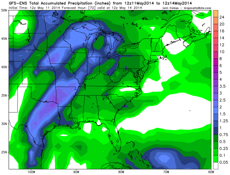
12zGFS Ensemble Mean has much of Texas with 1.5'' or more thru Wednesday Morning...would not be surprise for someone to get 6+ inches of Rain out of this event..

0 likes
The following post is NOT an official forecast and should not be used as such. It is just the opinion of the poster and may or may not be backed by sound meteorological data. It is NOT endorsed by any professional institution including storm2k.org For Official Information please refer to the NHC and NWS products.

Tomorrow will be an interesting day across our state for many who like rain. Some NWS WFO's are playing it conservative, but it does appear several rounds of MCS followed by overrunning for lots. Somebody will pick up a lot where the front slows and they stay in the warm sector. Models continue to show another slow moving trough to kick SW flow aloft beyond the cool down following this current trough in from the Pacific.
What needs to be watched is storms ahead of the MCS. Often surprises in severe weather occur before the arrival of such a large feature even if the risk appears low. And of course flash flooding.
What needs to be watched is storms ahead of the MCS. Often surprises in severe weather occur before the arrival of such a large feature even if the risk appears low. And of course flash flooding.
0 likes
The above post and any post by Ntxw is NOT an official forecast and should not be used as such. It is just the opinion of the poster and may or may not be backed by sound meteorological data. It is NOT endorsed by any professional institution including Storm2k. For official information, please refer to NWS products.
Help support Storm2K!
-
Rgv20
- S2K Supporter
- Posts: 2466
- Age: 39
- Joined: Wed Jan 05, 2011 5:42 pm
- Location: Edinburg/McAllen Tx
SPECIAL WEATHER STATEMENT
NATIONAL WEATHER SERVICE CORPUS CHRISTI TX
431 PM CDT SUN MAY 11 2014
TXZ229>234-239>247-121200-
LA SALLE-MCMULLEN-LIVE OAK-BEE-GOLIAD-VICTORIA-WEBB-DUVAL-
JIM WELLS-KLEBERG-NUECES-SAN PATRICIO-ARANSAS-REFUGIO-CALHOUN-
INCLUDING THE CITIES OF...COTULLA...CALLIHAM...CROSS...
LOMA ALTA...TILDEN...GEORGE WEST...THREE RIVERS...BEEVILLE...
GOLIAD...VICTORIA...LAREDO...FREER...BENAVIDES...SAN DIEGO...
ALICE...ORANGE GROVE...KINGSVILLE...CORPUS CHRISTI...PORTLAND...
INGLESIDE...ARANSAS PASS...SINTON...MATHIS...ROCKPORT...REFUGIO...
WOODSBORO...PORT LAVACA
431 PM CDT SUN MAY 11 2014
...GOOD CHANCE FOR STRONG TO SEVERE THUNDERSTORMS LATE MONDAY
AFTERNOON AND MONDAY NIGHT...
...HEAVY RAINFALL AND FLOODING POSSIBLE LATE MONDAY THROUGH TUESDAY...
A STRONG UPPER LEVEL STORM SYSTEM WILL COMBINE WITH PLENTIFUL
MOISTURE FROM LATE MONDAY AFTERNOON THROUGH MONDAY NIGHT.
ADDITIONAL STRONG TO SEVERE THUNDERSTORMS WILL STILL BE POSSIBLE
THROUGH TUESDAY AFTERNOON...BEFORE A STRONG LATE SEASON COLD FRONT
MOVES THROUGH THE AREA BY TUESDAY NIGHT.
THE STRONGER THUNDERSTORMS WILL PRODUCE WIND GUSTS BETWEEN 45 AND 55
MPH...WITH 60 MPH OR HIGHER GUSTS IN ANY SEVERE STORMS. DAMAGING
WINDS WILL CAUSE DANGEROUS CONDITIONS FOR HIGH PROFILE VEHICLES
AND MARINERS AT SEA. EXPECT DAMAGE TO MOBILE HOMES...PORCHES...AND
AWNINGS. LARGE FALLEN TREES WILL PRODUCE SCATTERED POWER OUTAGES.
ALSO...LARGE HAIL 1/2 TO 2 INCHES IN DIAMETER WILL BE POSSIBLE
WITH THESE STORMS. LARGE HAIL MAY CAUSE DAMAGE TO VEHICLES IN THE
FORM OF CHIPPED PAINT...DENTED BODY PANELS...AND BROKEN
WINDSHIELDS. DAMAGE MAY ALSO OCCUR TO VEGETATION AND ROOFING
SHINGLES. ANYONE CAUGHT OUTDOORS COULD FACE SERIOUS INJURY.
ALONG WITH THE POTENTIAL FOR SEVERE WEATHER...HEAVY RAINFALL WILL
BE LIKELY...FROM MONDAY NIGHT THROUGH EARLY WEDNESDAY MORNING.
DURING THIS TIME...RAINFALL AMOUNTS WILL AVERAGE BETWEEN 4 AND 5
INCHES OVER THE NORTHERN COASTAL BEND...VICTORIA AREA...AND EASTERN
BRUSH COUNTRY...AND 2 TO 4 INCHES OVER MOST OF THE REMAINDER OF
THE SOUTH TEXAS. SLIGHTLY LOWER AMOUNTS (LESS THAN 2 INCHES) ARE
EXPECTED OVER THE RIO GRANDE AND EXTREME SOUTHERN PORTIONS OF THE
COASTAL BEND. LOCALLY HIGHER AMOUNTS OF 7 OR MORE INCHES WILL BE
POSSIBLE...ESPECIALLY OVER THE AREAS WHERE THE HIGHEST AVERAGE
RAINFALL TOTALS ARE EXPECTED. A FLASH FLOOD WATCH MAY BE ISSUED ON
MONDAY FOR THIS POTENTIALLY HEAVY RAINFALL EVENT.
THERE IS A POSSIBILITY THAT AN ORGANIZED SYSTEM OF SHOWERS AND
THUNDERSTORMS...KNOWN AS A MESO-SCALE CONVECTIVE SYSTEM...WILL
DEVELOP MONDAY NIGHT AND PUSH THROUGH ALL OF SOUTH TEXAS BY NOON
TUESDAY. IF THAT HAPPENS...THEN RAIN CHANCES WILL LIKELY END WITH
THE PASSAGE OF THE SYSTEM.
DRIER WEATHER AND MUCH COOLER TEMPERATURES WILL MOVE INTO SOUTH
TEXAS ON WEDNESDAY BEHIND THE STRONG COLD FRONT. HIGHS ON
WEDNESDAY WILL ONLY BE IN THE 70S...WHILE OVERNIGHT LOWS
WEDNESDAY NIGHT WILL BE IN THE 50S OVER MOST LOCATIONS.
RESIDENTS SHOULD MONITOR THE LATEST WEATHER FORECASTS FROM YOUR
NATIONAL WEATHER SERVICE CONCERNING THIS POTENTIAL SEVERE AND
HEAVY RAINFALL EVENT. LISTEN TO YOUR NOAA WEATHER RADIO FOR THE
LATEST INFORMATION. YOU CAN ALSO GET THE LATEST WEATHER
FORECASTS...WATCHES AND WARNINGS BY VISITING OUR WEB SITE...
http://WWW.WEATHER.GOV/CORPUSCHRISTI
$$
GW
0 likes
The following post is NOT an official forecast and should not be used as such. It is just the opinion of the poster and may or may not be backed by sound meteorological data. It is NOT endorsed by any professional institution including storm2k.org For Official Information please refer to the NHC and NWS products.
-
gboudx

- S2K Supporter
- Posts: 4090
- Joined: Thu Sep 04, 2003 1:39 pm
- Location: Rockwall, Tx but from Harvey, La
I hope Steve is right about putting a major dent in the drought. Need to get the lakes filled up.
Scattered showers and thunderstorms will begin to fire across north Texas during the day Monday, and then a solid line of heavy thunderstorms will roll in from the west Monday late in the afternoon/early evening and continue on and off through Wednesday morning! And the rain that falls on Tuesday will be chilly with high temperatures struggling into the 60s, and it will just be a plain COLD RAIN Wednesday morning as we fall into the 40s !
This will be a MULTI-INCH RAIN for much of north Texas with the possibility of flash flooding. Some thunderstorms may be marginally severe with pocket-change hail on Monday afternoon/evening , but most storms will behave and will just be efficient rainmakers.
This still appears to be a 100% coverage not only for the Metroplex but for ALL of north Texas! In other words, last Thursday was just a preview. This is going to put a MAJOR dent in the drought and may wipe it out altogether for eastern sections of north Texas (just like the National Climatic Data Center predicted over a month ago...remember that forecast map !?!)
0 likes
If you still don't believe the Pacific Ocean (and it's oscillations be it the EPO or ENSO) dominates our weather after this and the drought, I don't know what does
0 likes
The above post and any post by Ntxw is NOT an official forecast and should not be used as such. It is just the opinion of the poster and may or may not be backed by sound meteorological data. It is NOT endorsed by any professional institution including Storm2k. For official information, please refer to NWS products.
Help support Storm2K!
Help support Storm2K!
-
South Texas Storms

- Professional-Met
- Posts: 4259
- Joined: Thu Jun 24, 2010 12:28 am
- Location: Houston, TX
Re: Texas Spring-2014
I'm really looking forward to the upcoming widespread heavy rain event across the eastern half of Texas. Some places could get more rain from this system than all of 2014 so far! Hopefully all of us can get at least 1 inch of beneficial rain in the next 72 hours!
0 likes
-
weatherdude1108
- Category 5
- Posts: 4228
- Joined: Tue Dec 13, 2011 1:04 pm
- Location: Northwest Austin/Cedar Park, TX
"FLOOD WATCH
NATIONAL WEATHER SERVICE AUSTIN/SAN ANTONIO TX
351 AM CDT MON MAY 12 2014
...FLASH FLOOD WATCH FROM 7 PM THIS EVENING UNTIL NOON TUESDAY
ALONG AND EAST OF U.S. HIGHWAY 83...
.MOIST GULF AIR...AND UPPER LEVEL TROUGH...AND A COLD FRONT WILL
COMBINE TO BRING SHOWERS AND THUNDERSTORMS TO THE AREA TODAY
THROUGH TUESDAY NIGHT. FAVORABLE THICKNESS DIFFLUENCE...CLIMATOLOGICALLY-
FAVORED THICKNESS VALUES...AND PRECIPITABLE WATER VALUES NEAR TWO
STANDARD DEVIATIONS ABOVE THE NORMAL FOR MAY ARE OFFSET BY A
MODERATE TO FAST-MOVING FRONT. OVERALL...EXPECT WIDESPREAD
RAINFALL OF 2-3 INCHES...WITH ISOLATED TOTALS UP TO 5 INCHES.
WHILE THOSE AREN`T PARTICULARLY HIGH VALUES...THEY COULD OCCUR IN
A 2-4 HOUR PERIOD...WHICH WILL PRODUCE FLASH FLOODING IN URBAN
AREAS AND FOR RIVERS SUCH AS THE SABINAL...FRIO...AND NUECES THAT
FLOW FROM NORTH TO SOUTH...AS RAIN ON THE HEADWATERS FLOWS
DOWNSTREAM AND COMBINES WITH FALLING RAIN TO PRODUCE A HIGHER
FLOOD WAVE.
TXC013-019-021-029-031-053-055-091-123-127-149-163-171-177-187-
209-255-259-265-285-287-299-325-385-453-463-491-493-507-121700-
/O.NEW.KEWX.FF.A.0001.140513T0000Z-140513T1700Z/
/00000.0.ER.000000T0000Z.000000T0000Z.000000T0000Z.OO/
ATASCOSA-BANDERA-BASTROP-BEXAR-BLANCO-BURNET-CALDWELL-COMAL-
DEWITT-DIMMIT-FAYETTE-FRIO-GILLESPIE-GONZALES-GUADALUPE-HAYS-
KARNES-KENDALL-KERR-LAVACA-LEE-LLANO-MEDINA-REAL-TRAVIS-UVALDE-
WILLIAMSON-WILSON-ZAVALA-
INCLUDING THE CITIES OF...PLEASANTON...BANDERA...BASTROP...
SAN ANTONIO...BLANCO...BURNET...LOCKHART...NEW BRAUNFELS...
CUERO...CARRIZO SPRINGS...LA GRANGE...PEARSALL...FREDERICKSBURG...
GONZALES...SEGUIN...SAN MARCOS...KARNES CITY...BOERNE...
KERRVILLE...HALLETTSVILLE...GIDDINGS...LLANO...HONDO...LEAKEY...
AUSTIN...UVALDE...GEORGETOWN...FLORESVILLE...CRYSTAL CITY
351 AM CDT MON MAY 12 2014
...FLASH FLOOD WATCH IN EFFECT FROM THIS EVENING THROUGH TUESDAY
MORNING...
THE NATIONAL WEATHER SERVICE IN AUSTIN/SAN ANTONIO HAS ISSUED A
* FLASH FLOOD WATCH FOR THE FOLLOWING COUNTIES IN SOUTH CENTRAL
TEXAS...ATASCOSA...BANDERA...BASTROP...BEXAR...BLANCO...
BURNET...CALDWELL...COMAL...DEWITT...DIMMIT...FAYETTE...FRIO...
GILLESPIE...GONZALES...GUADALUPE...HAYS...KARNES...KENDALL...
KERR...LAVACA...LEE...LLANO...MEDINA...REAL...TRAVIS...
UVALDE...WILLIAMSON...WILSON AND ZAVALA.
* FROM THIS EVENING THROUGH TUESDAY MORNING.
* WIDESPREAD RAINFALL OF 2-3 INCHES...WITH ISOLATED TOTALS TO 5
INCHES IS EXPECTED ACROSS THE AREA. THIS WILL PRODUCE FLASH
FLOODING...ESPECIALLY IN URBAN AREAS AND LOCATIONS ALONG NORTH
TO SOUTH FLOWING RIVERS AND CREEKS.
* WHILE MASSIVE RAINFALL AMOUNTS AND DEVASTATING FLOODS ARE NOT
EXPECTED...THERE IS STILL A SIGNIFICANT THREAT FOR DRIVING INTO
FLOOD WATERS AT LOW WATER CROSSINGS IN THE HILL COUNTRY AND IN
LOW-LYING SPOTS IN URBAN AREAS. AS ALWAYS...NEVER...EVER...DRIVE
WHERE WATER COVERS THE ROAD. SLOW DOWN AT NIGHT OR ANYTIME
VISIBILITY IS POOR. SAVE YOUR OWN LIFE...TURN AROUND...DON`T
DROWN.
PRECAUTIONARY/PREPAREDNESS ACTIONS...
A FLASH FLOOD WATCH MEANS FLASH FLOODING IS POSSIBLE IN OR NEAR
THE WATCH AREA. IF YOU ARE IN THE WATCH AREA...PLAN NOW FOR WHAT
YOU WILL DO IF FLASH FLOODING DEVELOPS. STAY INFORMED AND BE
READY TO ACT IF YOU SEE FLOODING OR IF A FLASH FLOOD WARNING IS
ISSUED.
&&
$$"
0 likes
The preceding post is NOT an official forecast, and should not be used as such. It is only the opinion of the poster and may or may not be backed by sound meteorological data. It is NOT endorsed by any professional institution including storm2k.org. For Official Information please refer to the NHC and NWS products.
-
gboudx
- S2K Supporter
- Posts: 4090
- Joined: Thu Sep 04, 2003 1:39 pm
- Location: Rockwall, Tx but from Harvey, La
Re: Texas Spring-2014
South Texas Storms wrote:I'm really looking forward to the upcoming widespread heavy rain event across the eastern half of Texas. Some places could get more rain from this system than all of 2014 so far! Hopefully all of us can get at least 1 inch of beneficial rain in the next 72 hours!
Congrats on the blue color and the new title.
From McCauley
Now that we are within 24 hours of our rain event, we can give a first guess on rainfall tallies. The eastern half of north Texas will once again see the highest rainfall totals with a multi-inch rain likely. But since the initial activity will be thunderstorms, we can expect a wide range in rain totals even over short distances, so these can be thought of as general averages across the area.
The best of the rain for the Metroplex will hold off until the middle of the afternoon and should arrive in the form of a solid line of storms moving into the Metroplex from the west and northwest. There is a threat of marginally severe storms with pocket-change hail and gusty winds, but the chilly air moving in behind the cold front should shut down the severe weather threat fairly quickly after the front passes.
The colder air surging in behind the front may also keep the flash flooding potential down by quickly transitioning the storms to just plain rain.
Stay tuned for updates !
0 likes
-
aggiecutter
- Category 5
- Posts: 1755
- Joined: Thu Oct 14, 2004 9:22 pm
- Location: Texarkana
...FLASH FLOOD WATCH IN EFFECT FROM THIS EVENING THROUGH TUESDAY
AFTERNOON...
THE NATIONAL WEATHER SERVICE IN SHREVEPORT HAS ISSUED A
* A FLASH FLOOD WATCH FOR PORTIONS OF SOUTHWEST ARKANSAS...
NORTHWEST LOUISIANA...SOUTHEAST OKLAHOMA AND NORTHEAST TEXAS...
INCLUDING THE FOLLOWING AREAS...IN SOUTHWEST ARKANSAS...
COLUMBIA...HEMPSTEAD...HOWARD...LAFAYETTE...LITTLE RIVER...
MILLER...NEVADA AND SEVIER. IN NORTHWEST LOUISIANA...BOSSIER...
CADDO AND WEBSTER. IN SOUTHEAST OKLAHOMA...MCCURTAIN. IN
NORTHEAST TEXAS...BOWIE...CAMP...CASS...CHEROKEE...FRANKLIN...
GREGG...HARRISON...MARION...MORRIS...PANOLA...RED RIVER...
RUSK...SMITH...TITUS...UPSHUR AND WOOD.
* FROM THIS 10 P.M. CDT EVENING THROUGH 4 P.M. CDT TUESDAY
AFTERNOON
* A SLOW MOVING COLD FRONT AND LARGE UPPER LEVEL TROUGH WILL
SLOWLY PUSH ACROSS THE FOUR STATE AREA AND FOCUS HEAVY RAINFALL
OVER MUCH OF REGION OVER THE COURSE OF THE NEXT DAY OR MORE.|
* WIDESPREAD RAINFALL FROM TRAINING SHOWERS AND THUNDERSTORMS WILL
LIKELY DEVELOP DURING THE OVERNIGHT HOURS AND CONTINUE THROUGH
THE DAY TUESDAY BEFORE SLACKING OFF FROM WEST TO EAST ACROSS THE
REGION. ADDITIONAL RAINFALL MAY DEVELOP LATE TUESDAY INTO
MIDWEEK AS WELL. FOR NOW...EXCESSIVE HEAVY RAINFALL ACROSS THE
REGION IS EXPECTED WITH STORM RAINFALL TOTALS OF TWO TO FOUR
INCHES POSSIBLE WITH ISOLATED HIGHER AMOUNTS. SOILS ARE FAIRLY
SATURATED FROM RECENT HEAVY RAINFALL ACROSS PORTIONS OF THE
REGION AND THUS...THE EXPECTED RAINFALL WITH THIS STORM SYSTEM
COULD RESULT IN WIDESPREAD FLASH FLOODING.
0 likes
-
angelwing

- S2K Supporter
- Posts: 4462
- Age: 64
- Joined: Tue Jan 18, 2005 3:06 pm
- Location: Kulpsville, PA
Re: Texas Spring-2014
South Texas Storms wrote:I'm really looking forward to the upcoming widespread heavy rain event across the eastern half of Texas. Some places could get more rain from this system than all of 2014 so far! Hopefully all of us can get at least 1 inch of beneficial rain in the next 72 hours!
Congrats on the new title!!!
0 likes
Agnes 72, Gloria 85, Floyd 99, Irene 2011, TS Lee 2012, Sandy 2012
-
Portastorm

- Storm2k Moderator

- Posts: 9955
- Age: 63
- Joined: Fri Jul 11, 2003 9:16 am
- Location: Round Rock, TX
- Contact:
Re: Texas Spring-2014
Some of you have noticed already and others, who maybe have not been to this forum in a bit, have not seen it but South Texas Storms is now South Texas Storms!
It is always inspiring to watch someone accomplish a great goal or achievement. Our own South Texas Storms this past weekend graduated from Texas A&M University with a degree in meteorology. He came to us as a "tweener" between high school and college and is now a professional, degreed meteorologist! We have been able to watch his progress and his growing knowledge in the subject matter we all love. And I know from personal experience that getting a degree in meteorology from Texas A&M is no small feat. I actually considered going that route years ago but declined when I learned just how much heavy duty math, physics, and other sciences were involved. Being an English major ... well ... you get the rest! South Texas Storms' achievement is something to celebrate and honor.
So, I hope you'll join me in virtually high five-ing South Texas Storms and congratulating him on this real life milestone. Now, I'll be really impressed if he can bring us several inches of rain this week!
It is always inspiring to watch someone accomplish a great goal or achievement. Our own South Texas Storms this past weekend graduated from Texas A&M University with a degree in meteorology. He came to us as a "tweener" between high school and college and is now a professional, degreed meteorologist! We have been able to watch his progress and his growing knowledge in the subject matter we all love. And I know from personal experience that getting a degree in meteorology from Texas A&M is no small feat. I actually considered going that route years ago but declined when I learned just how much heavy duty math, physics, and other sciences were involved. Being an English major ... well ... you get the rest!
So, I hope you'll join me in virtually high five-ing South Texas Storms and congratulating him on this real life milestone. Now, I'll be really impressed if he can bring us several inches of rain this week!
0 likes
Any forecasts under my name are to be taken with a grain of salt. Get your best forecasts from the National Weather Service and National Hurricane Center.
-
Tireman4
- S2K Supporter
- Posts: 5903
- Age: 60
- Joined: Fri Jun 30, 2006 1:08 pm
- Location: Humble, Texas
- Contact:
Re: Texas Spring-2014
Portastorm wrote:Some of you have noticed already and others, who maybe have not been to this forum in a bit, have not seen it but South Texas Storms is now South Texas Storms!
It is always inspiring to watch someone accomplish a great goal or achievement. Our own South Texas Storms this past weekend graduated from Texas A&M University with a degree in meteorology. He came to us as a "tweener" between high school and college and is now a professional, degreed meteorologist! We have been able to watch his progress and his growing knowledge in the subject matter we all love. And I know from personal experience that getting a degree in meteorology from Texas A&M is no small feat. I actually considered going that route years ago but declined when I learned just how much heavy duty math, physics, and other sciences were involved. Being an English major ... well ... you get the rest!
So, I hope you'll join me in virtually high five-ing South Texas Storms and congratulating him on this real life milestone. Now, I'll be really impressed if he can bring us several inches of rain this week!
Woo. Hoo. Great job sir. Now, Portastorm, you go get your meteorology degree!!!
0 likes
-
Ralph's Weather
- S2K Supporter
- Posts: 3371
- Age: 38
- Joined: Fri Dec 13, 2013 11:55 am
- Location: Lindale, TX
- Contact:
Re: Texas Spring-2014
Portastorm wrote:Some of you have noticed already and others, who maybe have not been to this forum in a bit, have not seen it but South Texas Storms is now South Texas Storms!
It is always inspiring to watch someone accomplish a great goal or achievement. Our own South Texas Storms this past weekend graduated from Texas A&M University with a degree in meteorology. He came to us as a "tweener" between high school and college and is now a professional, degreed meteorologist! We have been able to watch his progress and his growing knowledge in the subject matter we all love. And I know from personal experience that getting a degree in meteorology from Texas A&M is no small feat. I actually considered going that route years ago but declined when I learned just how much heavy duty math, physics, and other sciences were involved. Being an English major ... well ... you get the rest!
So, I hope you'll join me in virtually high five-ing South Texas Storms and congratulating him on this real life milestone. Now, I'll be really impressed if he can bring us several inches of rain this week!
I tried meteorology at A&M, but you are correct in saying the math and physics are hefty so I had to switch to geography.
0 likes
Follow on Facebook at Ralph's Weather.
Re: Texas Spring-2014
Congratulations South Texas Storms! Lots of hard work and dedication, looking forward to learning from you soon! Lets us all celebrate this fine achievement with lots of rain!
0 likes
The above post and any post by Ntxw is NOT an official forecast and should not be used as such. It is just the opinion of the poster and may or may not be backed by sound meteorological data. It is NOT endorsed by any professional institution including Storm2k. For official information, please refer to NWS products.
Help support Storm2K!
Help support Storm2K!
-
weatherdude1108
- Category 5
- Posts: 4228
- Joined: Tue Dec 13, 2011 1:04 pm
- Location: Northwest Austin/Cedar Park, TX
Re: Texas Spring-2014
Portastorm wrote:Some of you have noticed already and others, who maybe have not been to this forum in a bit, have not seen it but South Texas Storms is now South Texas Storms!
It is always inspiring to watch someone accomplish a great goal or achievement. Our own South Texas Storms this past weekend graduated from Texas A&M University with a degree in meteorology. He came to us as a "tweener" between high school and college and is now a professional, degreed meteorologist! We have been able to watch his progress and his growing knowledge in the subject matter we all love. And I know from personal experience that getting a degree in meteorology from Texas A&M is no small feat. I actually considered going that route years ago but declined when I learned just how much heavy duty math, physics, and other sciences were involved. Being an English major ... well ... you get the rest!
So, I hope you'll join me in virtually high five-ing South Texas Storms and congratulating him on this real life milestone. Now, I'll be really impressed if he can bring us several inches of rain this week!
Awesome!!
0 likes
-
Texas Snowman

- Storm2k Moderator
- Posts: 6197
- Joined: Fri Jan 25, 2008 11:29 am
- Location: Denison, Texas
Well done South Texas Storms! Well done! Take your bow!!!
Now let's get to work to get some liquid blue out of the sky and into the ground, lakes, rivers, and watershed around the Hook 'Em Horns! land that Portastorm lives in!
Again, well done and congratulations!
Now let's get to work to get some liquid blue out of the sky and into the ground, lakes, rivers, and watershed around the Hook 'Em Horns! land that Portastorm lives in!
Again, well done and congratulations!
0 likes
The above post and any post by Texas Snowman is NOT an official forecast and should not be used as such. It is just the opinion of the poster and may or may not be backed by sound meteorological data. It is NOT endorsed by any professional institution including storm2k.org. For official information, please refer to NWS products.
Return to “USA & Caribbean Weather”
Who is online
Users browsing this forum: No registered users and 111 guests