Significant Severe Weather Outbreak Possible 04/26-30/2014

U.S. & Caribbean Weather Discussions and Severe Weather Events

Moderator: S2k Moderators

Forum rules

The posts in this forum are NOT official forecast and should not be used as such. They are just the opinion of the poster and may or may not be backed by sound meteorological data. They are NOT endorsed by any professional institution or STORM2K.

Help Support Storm2K
Message
Author
User avatar
cycloneye
Admin
Admin
Posts: 145305
Age: 68
Joined: Thu Oct 10, 2002 10:54 am
Location: San Juan, Puerto Rico

Re:

#201 Postby cycloneye » Sun Apr 27, 2014 8:13 pm

Cyclenall wrote:The tornado is confirmed still on the ground, near Highway 64 and Hwy 5. Some injuries being reported.


Sad news from Mayflower.

Mike DeLeonardis ‏@ecography · 49s
Arkansas state police is reporting 1 fatality on Highway 365 in Mayflower, Arkansas.
0 likes   
Visit the Caribbean-Central America Weather Thread where you can find at first post web cams,radars
and observations from Caribbean basin members Click Here

User avatar
Bunkertor
Category 5
Category 5
Posts: 3397
Joined: Tue May 09, 2006 3:48 pm

#202 Postby Bunkertor » Sun Apr 27, 2014 8:16 pm

Those twitter attention whores should get their hands cut off
0 likes   

RL3AO
Moderator-Pro Met
Moderator-Pro Met
Posts: 16308
Joined: Thu Jun 14, 2007 10:03 pm
Location: NC

#203 Postby RL3AO » Sun Apr 27, 2014 8:19 pm

New TDS. Likely a tornado on the ground.
0 likes   

User avatar
Bunkertor
Category 5
Category 5
Posts: 3397
Joined: Tue May 09, 2006 3:48 pm

#204 Postby Bunkertor » Sun Apr 27, 2014 8:20 pm

0 likes   

RL3AO
Moderator-Pro Met
Moderator-Pro Met
Posts: 16308
Joined: Thu Jun 14, 2007 10:03 pm
Location: NC

#205 Postby RL3AO » Sun Apr 27, 2014 8:21 pm

Debris ball is back on CC

Image
0 likes   

RL3AO
Moderator-Pro Met
Moderator-Pro Met
Posts: 16308
Joined: Thu Jun 14, 2007 10:03 pm
Location: NC

Re:

#206 Postby RL3AO » Sun Apr 27, 2014 8:26 pm

Bunkertor wrote:From HurricaneDave on irc
http://www.spc.noaa.gov/exper/soundings ... BS/LZK.gif


Thats an unbelievable sounding.
0 likes   

User avatar
cheezyWXguy
Category 5
Category 5
Posts: 6108
Joined: Mon Feb 13, 2006 12:29 am
Location: Dallas, TX

Re: Significant Severe Weather Outbreak Possible 04/26-30/2014

#207 Postby cheezyWXguy » Sun Apr 27, 2014 8:29 pm

Could someone interpret that sounding for me?
0 likes   

RL3AO
Moderator-Pro Met
Moderator-Pro Met
Posts: 16308
Joined: Thu Jun 14, 2007 10:03 pm
Location: NC

#208 Postby RL3AO » Sun Apr 27, 2014 8:31 pm

Look at the direction of the wind barbs in the center of the image. Surface winds start from the southeast and veers towards the west in height. Its very strong directional wind shear.
0 likes   

apocalypt-flyer
Category 1
Category 1
Posts: 468
Joined: Sat Aug 27, 2005 11:51 am

Re: Significant Severe Weather Outbreak Possible 04/26-30/2014

#209 Postby apocalypt-flyer » Sun Apr 27, 2014 8:32 pm

Picture of the Mayflower-Vilonia Tornado:

Image
Last edited by apocalypt-flyer on Sun Apr 27, 2014 8:34 pm, edited 1 time in total.
0 likes   

User avatar
Cyclenall
Category 5
Category 5
Posts: 6666
Joined: Thu Jun 08, 2006 10:01 pm
Location: Ontario, Canada

Re:

#210 Postby Cyclenall » Sun Apr 27, 2014 8:34 pm

Bunkertor wrote:Those twitter attention whores should get their hands cut off

lol.

Its now dark and impossible to see any tornadoes in the area. Someone talking about a tornado impact from this monster said before the tornado came, the rain got hotter and hotter...never heard that one. Any explanation?
0 likes   

CrazyC83
Professional-Met
Professional-Met
Posts: 34002
Joined: Tue Mar 07, 2006 11:57 pm
Location: Deep South, for the first time!

#211 Postby CrazyC83 » Sun Apr 27, 2014 8:34 pm

Indeed, damage looks like EF-4. Hopefully there won't be any fatalities at least...
0 likes   

User avatar
cycloneye
Admin
Admin
Posts: 145305
Age: 68
Joined: Thu Oct 10, 2002 10:54 am
Location: San Juan, Puerto Rico

Re: Significant Severe Weather Outbreak Possible 04/26-30/2014

#212 Postby cycloneye » Sun Apr 27, 2014 8:36 pm

Note=If anyone has videos or photos,they can be posted at the Sticky 2014 U.S severe season mother thread.
0 likes   
Visit the Caribbean-Central America Weather Thread where you can find at first post web cams,radars
and observations from Caribbean basin members Click Here

User avatar
Bunkertor
Category 5
Category 5
Posts: 3397
Joined: Tue May 09, 2006 3:48 pm

Re:

#213 Postby Bunkertor » Sun Apr 27, 2014 8:40 pm

RL3AO wrote:Look at the direction of the wind barbs in the center of the image. Surface winds start from the southeast and veers towards the west in height. Its very strong directional wind shear.

And there is a learning page at NOAA. You have to type "soundings" there
0 likes   

User avatar
Cyclenall
Category 5
Category 5
Posts: 6666
Joined: Thu Jun 08, 2006 10:01 pm
Location: Ontario, Canada

Re:

#214 Postby Cyclenall » Sun Apr 27, 2014 8:48 pm

CrazyC83 wrote:Indeed, damage looks like EF-4. Hopefully there won't be any fatalities at least...

There is already 1 death confirmed from a highway. There was a video shown on the highway I talked about that was very surreal, loud noises and chaos everywhere. Don't know the context but should pop up somewhere.


EDIT: Reports of the tornado still on the ground near Denmark!! :eek:
0 likes   

RL3AO
Moderator-Pro Met
Moderator-Pro Met
Posts: 16308
Joined: Thu Jun 14, 2007 10:03 pm
Location: NC

#215 Postby RL3AO » Sun Apr 27, 2014 8:51 pm

Tornado emergency back
0 likes   

CrazyC83
Professional-Met
Professional-Met
Posts: 34002
Joined: Tue Mar 07, 2006 11:57 pm
Location: Deep South, for the first time!

#216 Postby CrazyC83 » Sun Apr 27, 2014 8:52 pm

MESOSCALE DISCUSSION 0439
NWS STORM PREDICTION CENTER NORMAN OK
0843 PM CDT SUN APR 27 2014

AREAS AFFECTED...PORTIONS OF ERN OK...AR...SERN MO

CONCERNING...TORNADO WATCH 100...102...103...

VALID 280143Z - 280245Z

THE SEVERE WEATHER THREAT FOR TORNADO WATCH
100...102...103...CONTINUES.

SUMMARY...THE RISK FOR SEVERE THUNDERSTORMS INCLUDING TORNADOES
CONTINUES ACROSS TORNADO WATCHES 100...102...AND 103.

DISCUSSION...THE ONGOING SEVERE THUNDERSTORM AND TORNADO POTENTIAL
ACROSS TORNADO WATCHES 100...102...AND 103 IS EVOLVING IN TWO
REGIMES:

/1/ PRE-FRONTAL SEMI-DISCRETE/DISCRETE SUPERCELLS ARE ADVANCING NEWD
FROM CNTRL AR INTO NERN AR AIDED BY A STRENGTHENING LLJ. UPPER
60S/LOWER 70S SFC-DEWPOINT AIR IS RETREATING NEWD TO SUPPORT
LOWERING OF EFFECTIVE INFLOW LAYERS FOR THE ONGOING CONVECTION.
AND...WITH AROUND 450-600 M2/S2 OF 0-1-KM SRH INDICATED BY RECENT
LZK VWP DATA THAT DEPICT A LONG...LOOPING LOW-LEVEL
HODOGRAPH...TORNADOES -- SOME POSSIBLY SIGNIFICANT -- MAY ACCOMPANY
THIS ACTIVITY. LARGE HAIL AND DAMAGING WINDS WILL ALSO BE POSSIBLE.

/2/ WATER VAPOR LOOPS IMPLY AN ARCING BAND OF ENHANCED MID-LEVEL
ASCENT/MOISTURE OVERTAKING A STALLED BOUNDARY OVER SERN
OK...SUPPORTING THE INITIATION OF CONVECTION. THIS ACTIVITY WILL
LIKELY EXHIBIT QUASI-LINEAR MODES AS IT DEVELOPS ALONG THE FRONT AND
WILL POSE THE RISK FOR DMGG WINDS AND LARGE HAIL. SRX VWP DATA
INDICATE AROUND 25-30 KT OF 0-1-KM BULK SHEAR SUGGESTING SOME
TORNADO THREAT WILL EXIST AS WELL...AS THIS ACTIVITY SPREADS EWD
ACROSS SERN/E-CNTRL OK AND EVENTUALLY INTO PARTS OF WRN AR.

..COHEN.. 04/28/2014


ATTN...WFO...PAH...MEG...LZK...SGF...SHV...TSA...

LAT...LON 35249506 35759320 36159216 36709067 36869001 36208976
35209017 34599098 33769235 33609387 34009568 35249506
0 likes   

User avatar
AdamFirst
S2K Supporter
S2K Supporter
Posts: 2491
Age: 36
Joined: Thu Aug 14, 2008 10:54 am
Location: Port Saint Lucie, FL

Re:

#217 Postby AdamFirst » Sun Apr 27, 2014 8:53 pm

RL3AO wrote:Tornado emergency back


SEVERE WEATHER STATEMENT
NATIONAL WEATHER SERVICE LITTLE ROCK AR
850 PM CDT SUN APR 27 2014

ARC063-067-145-280215-
/O.CON.KLZK.TO.W.0014.000000T0000Z-140428T0215Z/
INDEPENDENCE AR-JACKSON AR-WHITE AR-
850 PM CDT SUN APR 27 2014

...TORNADO EMERGENCY FOR THIDA AND OIL TROUGH...

...A TORNADO WARNING REMAINS IN EFFECT FOR NORTH CENTRAL WHITE...WEST
CENTRAL JACKSON AND SOUTH CENTRAL INDEPENDENCE COUNTIES UNTIL 915 PM
CDT...

AT 845 PM CDT...STORM SPOTTERS AND NATIONAL WEATHER SERVICE
METEOROLOGISTS WERE TRACKING A CONFIRMED TORNADO WITH REPORTS OF
DAMAGE. THIS POTENTIALLY DEADLY TORNADO WAS LOCATED 6 MILES
NORTHEAST OF STEPROCK...OR 17 MILES NORTHEAST OF SEARCY...MOVING
NORTHEAST AT 45 MPH.

THIS IS A TORNADO EMERGENCY FOR THIDA AND OIL TROUGH. TAKE COVER
NOW.
0 likes   
Dolphins Marlins Canes Golden Panthers HEAT
Andrew 1992 - Irene 1999 - Frances 2004 - Jeanne 2004 - Wilma 2005 - Fay 2008 - Isaac 2012 - Matthew 2016 - Irma 2017 - Dorian 2019 - Ian 2022 - Nicole 2022 - Milton 2024

CrazyC83
Professional-Met
Professional-Met
Posts: 34002
Joined: Tue Mar 07, 2006 11:57 pm
Location: Deep South, for the first time!

Re: Significant Severe Weather Outbreak Possible 04/26-30/2014

#218 Postby CrazyC83 » Sun Apr 27, 2014 8:53 pm

SEVERE WEATHER STATEMENT
NATIONAL WEATHER SERVICE LITTLE ROCK AR
850 PM CDT SUN APR 27 2014

ARC063-067-145-280215-
/O.CON.KLZK.TO.W.0014.000000T0000Z-140428T0215Z/
INDEPENDENCE AR-JACKSON AR-WHITE AR-
850 PM CDT SUN APR 27 2014

...TORNADO EMERGENCY FOR THIDA AND OIL TROUGH...

...A TORNADO WARNING REMAINS IN EFFECT FOR NORTH CENTRAL WHITE...WEST
CENTRAL JACKSON AND SOUTH CENTRAL INDEPENDENCE COUNTIES UNTIL 915 PM
CDT...

AT 845 PM CDT...STORM SPOTTERS AND NATIONAL WEATHER SERVICE
METEOROLOGISTS WERE TRACKING A CONFIRMED TORNADO WITH REPORTS OF
DAMAGE. THIS POTENTIALLY DEADLY TORNADO WAS LOCATED 6 MILES
NORTHEAST OF STEPROCK...OR 17 MILES NORTHEAST OF SEARCY...MOVING
NORTHEAST AT 45 MPH.

THIS IS A TORNADO EMERGENCY FOR THIDA AND OIL TROUGH. TAKE COVER
NOW.

* LOCATIONS IN OR NEAR THE PATH OF THIS TORNADO INCLUDE...
PLEASANT PLAINS... OIL TROUGH... NEWARK...
VELVET RIDGE... THIDA... ROOSEVELT...
POSSUM GRAPE... OLYPHANT... MACKS...
HEFFINGTON... GRAY... DENMARK...

PRECAUTIONARY/PREPAREDNESS ACTIONS...

TO REPEAT...A DAMAGING TORNADO IS ON THE GROUND. THIS IS AN
EXCEPTIONALLY DANGEROUS SITUATION. THIS STORM IS PRODUCING A LIFE
THREATENING...CONFIRMED TORNADO CAPABLE OF SIGNIFICANT DESTRUCTION.
TAKE COVER IMMEDIATELY.


&&

A TORNADO WATCH REMAINS IN EFFECT UNTIL 200 AM CDT MONDAY MORNING FOR
NORTHEASTERN ARKANSAS.

LAT...LON 3550 9172 3573 9143 3553 9124 3538 9159
TIME...MOT...LOC 0150Z 232DEG 41KT 3550 9153

$$

44
0 likes   

User avatar
Cyclenall
Category 5
Category 5
Posts: 6666
Joined: Thu Jun 08, 2006 10:01 pm
Location: Ontario, Canada

Re: Significant Severe Weather Outbreak Possible 04/26-30/2014

#219 Postby Cyclenall » Sun Apr 27, 2014 8:54 pm

Also, a media report showed a pic of a house that was destroyed in the Vilonia tornado in 2011 that had been re-built, now destroyed once again!!! :eek: Insanity.
0 likes   

User avatar
cycloneye
Admin
Admin
Posts: 145305
Age: 68
Joined: Thu Oct 10, 2002 10:54 am
Location: San Juan, Puerto Rico

Re: Significant Severe Weather Outbreak Possible 04/26-30/2014

#220 Postby cycloneye » Sun Apr 27, 2014 9:13 pm

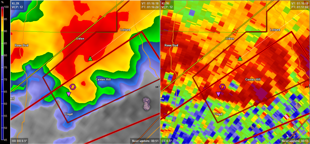
Here is how the Vilonia tornado looked at radar just before it hit.

Image
0 likes   
Visit the Caribbean-Central America Weather Thread where you can find at first post web cams,radars
and observations from Caribbean basin members Click Here


Return to “USA & Caribbean Weather”

Who is online

Users browsing this forum: ElectricStorm, txtwister78 and 12 guests