Texas Fall 2013

U.S. & Caribbean Weather Discussions and Severe Weather Events

Moderator: S2k Moderators

Forum rules

The posts in this forum are NOT official forecast and should not be used as such. They are just the opinion of the poster and may or may not be backed by sound meteorological data. They are NOT endorsed by any professional institution or STORM2K.

Help Support Storm2K
Message
Author
User avatar
Ntxw
Storm2k Moderator
Storm2k Moderator
Posts: 22784
Joined: Wed Oct 21, 2009 6:34 pm
Location: DFW, Texas

Re:

#1341 Postby Ntxw » Mon Nov 25, 2013 11:33 pm

somethingfunny wrote:How does this projected pattern compare to some of the great December freezes of the past?


We don't know. The pattern to deliver cold is being set up much like what we just saw. Of course next it will be near the solstice so it will have more bite. At the very least it will be as cold if not colder than what we just saw. If we're talking record cold there is just no way to know until you see the air mass. How long the Npac ridge stays will also determine the severity.
0 likes   
The above post and any post by Ntxw is NOT an official forecast and should not be used as such. It is just the opinion of the poster and may or may not be backed by sound meteorological data. It is NOT endorsed by any professional institution including Storm2k. For official information, please refer to NWS products.

  Help support Storm2K!
Help Support Storm2K

gpsnowman
S2K Supporter
S2K Supporter
Posts: 3185
Joined: Fri Jan 07, 2011 10:35 am
Location: Grand Prairie Tx

#1342 Postby gpsnowman » Mon Nov 25, 2013 11:44 pm

0 likes   

User avatar
Ntxw
Storm2k Moderator
Storm2k Moderator
Posts: 22784
Joined: Wed Oct 21, 2009 6:34 pm
Location: DFW, Texas

#1343 Postby Ntxw » Mon Nov 25, 2013 11:59 pm

Look at the number and look at the date. Focus on the value at the bottom right

Image

This is what 1989 looked like if you wondered what it was like on a map.
0 likes   
The above post and any post by Ntxw is NOT an official forecast and should not be used as such. It is just the opinion of the poster and may or may not be backed by sound meteorological data. It is NOT endorsed by any professional institution including Storm2k. For official information, please refer to NWS products.


  Help support Storm2K!

Help Support Storm2K


User avatar
Texas Snowman
Storm2k Moderator
Storm2k Moderator
Posts: 6179
Joined: Fri Jan 25, 2008 11:29 am
Location: Denison, Texas

#1344 Postby Texas Snowman » Tue Nov 26, 2013 12:02 am

A little perspective about the December 1983 cold wave:

DFW Records:

Dec 21 Record low: 10
Dec 23: Record low max 19
Dec 24: All-time record low max for any December date:13 degrees ( low of 7)
Dec 25: Coldest DFW Christmas on record, low of 6 and a high of 18 degrees!
Dec 26: Record low 16, Record low max of 29
Dec 27: Record low max of 31
Dec 29: Record low of 10
Dec 30: Record low of 7
Consecutive hours at or below freezing: 295: 7am Dec 18 to 2pm Dec 30, 1983

http://www.examiner.com/article/dallas- ... stands-out
0 likes   
The above post and any post by Texas Snowman is NOT an official forecast and should not be used as such. It is just the opinion of the poster and may or may not be backed by sound meteorological data. It is NOT endorsed by any professional institution including storm2k.org. For official information, please refer to NWS products.

User avatar
Texas Snowman
Storm2k Moderator
Storm2k Moderator
Posts: 6179
Joined: Fri Jan 25, 2008 11:29 am
Location: Denison, Texas

#1345 Postby Texas Snowman » Tue Nov 26, 2013 12:13 am

Very interesting information on severe freezes making it all the way into the Rio Grande Valley:

1895-1962: http://www.raingardens.com/psst/articles/artic02.htm

1980s: http://www.raingardens.com/psst/articles/artic03.htm
0 likes   
The above post and any post by Texas Snowman is NOT an official forecast and should not be used as such. It is just the opinion of the poster and may or may not be backed by sound meteorological data. It is NOT endorsed by any professional institution including storm2k.org. For official information, please refer to NWS products.

User avatar
Rgv20
S2K Supporter
S2K Supporter
Posts: 2466
Age: 38
Joined: Wed Jan 05, 2011 5:42 pm
Location: Edinburg/McAllen Tx

#1346 Postby Rgv20 » Tue Nov 26, 2013 12:22 am

:uarrow: That has been my guide for many years to noticing what kind of patterns lead to severe freezes for my area!
0 likes   
The following post is NOT an official forecast and should not be used as such. It is just the opinion of the poster and may or may not be backed by sound meteorological data. It is NOT endorsed by any professional institution including storm2k.org For Official Information please refer to the NHC and NWS products.

weatherdude1108
Category 5
Category 5
Posts: 4228
Joined: Tue Dec 13, 2011 1:04 pm
Location: Northwest Austin/Cedar Park, TX

#1347 Postby weatherdude1108 » Tue Nov 26, 2013 12:27 am

:uarrow:
Wow! :eek: Interesting links! The 1890s were BRUTAL with the cold across the valley and entire state. Pipe buster events for sure! :cold:
0 likes   
The preceding post is NOT an official forecast, and should not be used as such. It is only the opinion of the poster and may or may not be backed by sound meteorological data. It is NOT endorsed by any professional institution including storm2k.org. For Official Information please refer to the NHC and NWS products.

User avatar
Rgv20
S2K Supporter
S2K Supporter
Posts: 2466
Age: 38
Joined: Wed Jan 05, 2011 5:42 pm
Location: Edinburg/McAllen Tx

#1348 Postby Rgv20 » Tue Nov 26, 2013 12:28 am

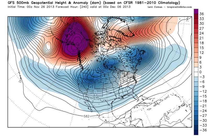
0zGFS shows major blocking in Alaska by day 10!

Image
0 likes   
The following post is NOT an official forecast and should not be used as such. It is just the opinion of the poster and may or may not be backed by sound meteorological data. It is NOT endorsed by any professional institution including storm2k.org For Official Information please refer to the NHC and NWS products.

richtrav
Tropical Storm
Tropical Storm
Posts: 184
Joined: Mon Sep 19, 2005 9:48 pm
Location: South Texas

Re: Texas Fall 2013

#1349 Postby richtrav » Tue Nov 26, 2013 2:05 am

I can't imagine something as strong as '83 or '89 in the works just yet since it's still early. I think 1983 actually had the stronger high associated with it but '89 had a more favorable pattern for the delivery of Arctic air to the Gulf coast states; someone correct me if I'm wrong.

With the western bias the GFS (and apparently the Euro) keeps spitting out is anyone else getting the feeling of a potential December 1990 redux? There was also a strong cold outbreak in early Dec 1978 down into Arizona that would be interesting to look into as a potential analog, I don't know the specifics of it.

Somewhere on a backup drive I have part I of those old articles saved, it went back as far as 1847. There was a strong radiation freeze at Ft. Brown in early Dec 1850. Starting around 1867 to 1870 the frequency of severe cold outbreaks increased quite a bit and lasted at least until 1899. I doubt the citrus industry would have ever taken off down here if it had started 30-40 years earlier.
0 likes   

User avatar
TeamPlayersBlue
Category 5
Category 5
Posts: 3445
Joined: Tue Feb 02, 2010 1:44 am
Location: Denver/Applewood, CO

#1350 Postby TeamPlayersBlue » Tue Nov 26, 2013 2:17 am

If this actually pans out, that wold be insane.
0 likes   
Personal Forecast Disclaimer:
The posts in this forum are NOT official forecast and should not be used as such. They are just the opinion of the poster and may or may not be backed by sound meteorological data. They are NOT endorsed by any professional institution or storm2k.org. For official information, please refer to the NHC and NWS products.

User avatar
somethingfunny
ChatStaff
ChatStaff
Posts: 3926
Age: 37
Joined: Thu May 31, 2007 10:30 pm
Location: McKinney, Texas

#1351 Postby somethingfunny » Tue Nov 26, 2013 4:27 am

If any of you are awake right now in DFW, the local airports are reporting variations on Light Drizzle/Light Rain/Mist and neither Base nor Composite Radar are showing anything, but I just stepped outside in South Garland and there are flurries flying around!
0 likes   
I am not a meteorologist, and any posts made by me are not official forecasts or to be interpreted as being intelligent. These posts are just my opinions and are probably silly opinions.

User avatar
srainhoutx
S2K Supporter
S2K Supporter
Posts: 6919
Age: 67
Joined: Sun Jan 14, 2007 11:34 am
Location: Haywood County, NC
Contact:

Re: Texas Fall 2013

#1352 Postby srainhoutx » Tue Nov 26, 2013 5:55 am

Seeing some reports of light snow flurries in the Dallas/Ft Worth and the San Angelo areas this morning as the cold pocket associated with the upper low continues to advance towards Central Texas. The Austin area on down toward I-10 may see some snow flurries this morning through about 10:00 AM as well. A special sounding was done by Texas A & M in College Station this morning sugggesting a saturated column below freezing except near the surface. There may be a brief window for a few stray snow flurries or sleet across portions of SE Texas as water vapor imagery does show some colder cloud tops advancing our way from the West. That upper low/trough should move across SE Texas during the day and finally end any chance of moisture and finally begin to clear out this cloudy/wet weather in time for Thanksgiving. An area wide freeze is possible except for those near the Coast early Thanksgiving morning and a warming trend begins to end the month of November.
0 likes   
Carla/Alicia/Jerry(In The Eye)/Michelle/Charley/Ivan/Dennis/Katrina/Rita/Wilma/Ike/Harvey

Member: National Weather Association
Wx Infinity Forums
http://wxinfinity.com/index.php

Facebook.com/WeatherInfinity
Twitter @WeatherInfinity

User avatar
wxman57
Moderator-Pro Met
Moderator-Pro Met
Posts: 22978
Age: 67
Joined: Sat Jun 21, 2003 8:06 pm
Location: Houston, TX (southwest)

Re: Texas Fall 2013

#1353 Postby wxman57 » Tue Nov 26, 2013 8:47 am

srain,

Did you see that CLL special sounding? I have it up on my screen and am comparing to the latest RUC sounding for CLL. The actual sounding showed warmer temps aloft than the RUC is seeing. It's also warmer than the NAM. GFS is too warm aloft. Looks like around 42F at 6000-7000ft. The RUC has the entire column below freezing, which is way too cold. Actual sounding indicates sleet possible.
0 likes   

User avatar
Portastorm
Storm2k Moderator
Storm2k Moderator
Posts: 9914
Age: 63
Joined: Fri Jul 11, 2003 9:16 am
Location: Round Rock, TX
Contact:

Re: Texas Fall 2013

#1354 Postby Portastorm » Tue Nov 26, 2013 8:50 am

wxman57 wrote:srain,

Did you see that CLL special sounding? I have it up on my screen and am comparing to the latest RUC sounding for CLL. The actual sounding showed warmer temps aloft than the RUC is seeing. It's also warmer than the NAM. GFS is too warm aloft. Looks like around 42F at 6000-7000ft. The RUC has the entire column below freezing, which is way too cold. Actual sounding indicates sleet possible.


A nice sleet shower for wxman57 ... now that's just what the PWC ordered! :wink:

Meanwhile, PWC weather observers are ready to snap photos if any snow flurries actually do fall in scenic southwest Travis County. However, I do not think they will. The upper level low is currently just to our south and it looks moisture starved in my area. East or southeast Texas though may end up with something fun to talk about.
0 likes   
Any forecasts under my name are to be taken with a grain of salt. Get your best forecasts from the National Weather Service and National Hurricane Center.

natlib
Tropical Storm
Tropical Storm
Posts: 159
Joined: Tue Dec 01, 2009 10:09 am
Location: San Angelo, TX

#1355 Postby natlib » Tue Nov 26, 2013 9:14 am

The snow flurries came through San Angelo around 5:45 this morning.....not much to look at....but snow nonetheless.

We should see the sun here for the first time in 6 days today. Then I'm ready for the next cold blast....
0 likes   

User avatar
srainhoutx
S2K Supporter
S2K Supporter
Posts: 6919
Age: 67
Joined: Sun Jan 14, 2007 11:34 am
Location: Haywood County, NC
Contact:

Re: Texas Fall 2013

#1356 Postby srainhoutx » Tue Nov 26, 2013 9:25 am

wxman57 wrote:srain,

Did you see that CLL special sounding? I have it up on my screen and am comparing to the latest RUC sounding for CLL. The actual sounding showed warmer temps aloft than the RUC is seeing. It's also warmer than the NAM. GFS is too warm aloft. Looks like around 42F at 6000-7000ft. The RUC has the entire column below freezing, which is way too cold. Actual sounding indicates sleet possible.


Just saw it, wxman57. I did receive a report around 6:00AM via text that flurries we falling in CLL and I see Jeff has seen the same thing... :wink:

Morning e-mail from Jeff:

Upper level storm system currently over SC TX with the last well defined wave of rain moving along I-45 at the moment. Rainfall amounts have averaged 1-3 inches across the region since Sunday afternoon.

Special 09Z (300am) sounding was launched from the met group at Texas A&M and showed a roughly 3,000 ft warm layer above the surface which has helped keep most of the precipitation rain this morning. College Station did report light snow with a visibility of 4.0 miles around 600am. No other reporting sites have reported anything but rainfall this morning. Should see the actual light rain move out of the area in the next 1-2 hours, but some drizzle or flurries will continue into the early afternoon hours. Temperatures will struggle to get much above 40 degrees today with increased cold air advection and thick cloud cover. Winds have also increased this morning with gust at or above 30mph along the coast as the offshore surface low pressure system continues to deepen.

Skies finally clear out tonight into Wednesday while additional cold air flows southward into the region. Looks like we are sitting up for a good widespread freeze on Thanksgiving morning with model guidance showing lows ranging from 27 to 30 at BUSH IAH which mean many locations outside the urban heat island will be cooler. Will need a freeze warning for areas along and S of I-10 which have not frozen yet this fall. Could see up to 3-5 hours at or below freezing so sensitive plants will need protection. Still cool but mainly clear on Thanksgiving Day with highs in the upper 50’s with some high clouds.

Onshore flow resumes by Friday with moisture starting a slow increase. Should see lower clouds work into the region on Saturday, but any threat for rainfall will hold off until late Sunday.

Very long range models continue to suggest a significant arctic air intrusion toward the second week of December.
0 likes   
Carla/Alicia/Jerry(In The Eye)/Michelle/Charley/Ivan/Dennis/Katrina/Rita/Wilma/Ike/Harvey

Member: National Weather Association
Wx Infinity Forums
http://wxinfinity.com/index.php

Facebook.com/WeatherInfinity
Twitter @WeatherInfinity

User avatar
wxman57
Moderator-Pro Met
Moderator-Pro Met
Posts: 22978
Age: 67
Joined: Sat Jun 21, 2003 8:06 pm
Location: Houston, TX (southwest)

Re: Texas Fall 2013

#1357 Postby wxman57 » Tue Nov 26, 2013 9:31 am

I'd ask if that observation of "light snow flurries" at CLL was by an automated station or a person. The sounding indicates snow would not be possible unless a small pocket of colder air passed by briefly. Sometimes very light drizzle floating in the wind is mistaken for snow flurries.
0 likes   

User avatar
srainhoutx
S2K Supporter
S2K Supporter
Posts: 6919
Age: 67
Joined: Sun Jan 14, 2007 11:34 am
Location: Haywood County, NC
Contact:

Re: Texas Fall 2013

#1358 Postby srainhoutx » Tue Nov 26, 2013 9:52 am

Reports of snow flurries in Fredricksburg and Dripping Springs.
0 likes   
Carla/Alicia/Jerry(In The Eye)/Michelle/Charley/Ivan/Dennis/Katrina/Rita/Wilma/Ike/Harvey

Member: National Weather Association
Wx Infinity Forums
http://wxinfinity.com/index.php

Facebook.com/WeatherInfinity
Twitter @WeatherInfinity

User avatar
TeamPlayersBlue
Category 5
Category 5
Posts: 3445
Joined: Tue Feb 02, 2010 1:44 am
Location: Denver/Applewood, CO

#1359 Postby TeamPlayersBlue » Tue Nov 26, 2013 10:08 am

Just stood outside for a few minutes. This is the kind of weather i want on Turkey day and Christmas. Wooo its cold though. Just a steady very light mist. Radar isnt seeing it. 99% humidity will do that. I have 40.3F at my weather center so it was all liquid. Keeping an eye out though
0 likes   
Personal Forecast Disclaimer:
The posts in this forum are NOT official forecast and should not be used as such. They are just the opinion of the poster and may or may not be backed by sound meteorological data. They are NOT endorsed by any professional institution or storm2k.org. For official information, please refer to the NHC and NWS products.

User avatar
srainhoutx
S2K Supporter
S2K Supporter
Posts: 6919
Age: 67
Joined: Sun Jan 14, 2007 11:34 am
Location: Haywood County, NC
Contact:

Re: Texas Fall 2013

#1360 Postby srainhoutx » Tue Nov 26, 2013 11:00 am

Code: Select all

PRELIMINARY LOCAL STORM REPORT...SUMMARY
NATIONAL WEATHER SERVICE AUSTIN/SAN ANTONIO TX
948 AM CST TUE NOV 26 2013

..TIME...   ...EVENT...      ...CITY LOCATION...     ...LAT.LON...
..DATE...   ....MAG....      ..COUNTY LOCATION..ST.. ...SOURCE....
            ..REMARKS..

0700 AM     SNOW             5 W FREDERICKSBURG      30.27N  98.95W
11/26/2013  M0.0 INCH        GILLESPIE          TX   COCORAHS

            SNOW FLURRIES

0700 AM     SNOW             3 NW INGRAM             30.11N  99.27W
11/26/2013  M0.0 INCH        KERR               TX   COCORAHS

            LIGHT SNOW AT 7 AM OBSERVATION TIME

0738 AM     SNOW             3 N HARPER              30.34N  99.25W
11/26/2013  M0.0 INCH        GILLESPIE          TX   TRAINED SPOTTER

            SNOW FLURRIES

0741 AM     SNOW             14 NW INGRAM            30.22N  99.40W
11/26/2013  M0.0 INCH        KERR               TX   COCORAHS

            TRACE OF LIGHT SNOW OVER THE PAST 15 MINUTES

0759 AM     SNOW             JOHNSON CITY            30.27N  98.41W
11/26/2013  M0.0 INCH        BLANCO             TX   BROADCAST MEDIA

            SNOW FLURRIES

0803 AM     SNOW             ROCKSPRINGS             30.02N 100.21W
11/26/2013  M0.0 INCH        EDWARDS            TX   COCORAHS

            LIGHT SNOW...NO ACCUMULATION

0821 AM     SNOW             KERRVILLE               30.04N  99.14W
11/26/2013  M0.0 INCH        KERR               TX   PUBLIC

0825 AM     SNOW             4 W FREDERICKSBURG      30.27N  98.94W
11/26/2013  M0.0 INCH        GILLESPIE          TX   BROADCAST MEDIA

            SNOW FLURRIES ALONG US 290

0836 AM     SNOW             DRIPPING SPRINGS        30.19N  98.09W
11/26/2013  M0.0 INCH        HAYS               TX   BROADCAST MEDIA

            SNOW FLURRIES

0922 AM     SNOW             WARING                  29.95N  98.80W
11/26/2013  M0.0 INCH        KENDALL            TX   TRAINED SPOTTER

            LIGHT SNOW IN WARING AND WELFARE FOR THE PAST 30
            MINUTES


&&

EVENT NUMBER EWX1300676 EWX1300677 EWX1300673 EWX1300672 EWX1300674
EWX1300675 EWX1300678 EWX1300679 EWX1300681 EWX1300680

$$

CVP

0 likes   
Carla/Alicia/Jerry(In The Eye)/Michelle/Charley/Ivan/Dennis/Katrina/Rita/Wilma/Ike/Harvey

Member: National Weather Association
Wx Infinity Forums
http://wxinfinity.com/index.php

Facebook.com/WeatherInfinity
Twitter @WeatherInfinity


Return to “USA & Caribbean Weather”

Who is online

Users browsing this forum: txtwister78 and 13 guests