Texas Fall 2013
Moderator: S2k Moderators
Forum rules

The posts in this forum are NOT official forecast and should not be used as such. They are just the opinion of the poster and may or may not be backed by sound meteorological data. They are NOT endorsed by any professional institution or STORM2K.
-
cctxhurricanewatcher

- Category 5

- Posts: 1206
- Joined: Sun Sep 12, 2004 8:53 pm
- Location: Corpus Christi, Texas
Texas Fall 2013
Could some area have some high school playoff football in the snow on Saturday? That would be a thrill for some kids for sure.
0 likes

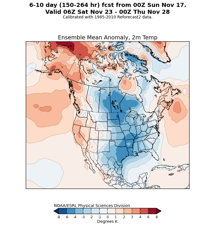
It will be interesting to note how cold the air mass coming down is. Even the GFS is pulling for a 1050+ high near the US/Canadian border. That is very impressive for November and it is of Arctic origin. Shallow air masses have been abundant this month and with such a big high I wonder if another one that beats the models as we get closer. I think we may be looking at a potential blizzard/ice storm in the making for someone in the southern plains. I-20 corridor to I-40 corridor should be on bears watch.
Last edited by Ntxw on Sun Nov 17, 2013 11:31 pm, edited 1 time in total.
0 likes
The above post and any post by Ntxw is NOT an official forecast and should not be used as such. It is just the opinion of the poster and may or may not be backed by sound meteorological data. It is NOT endorsed by any professional institution including Storm2k. For official information, please refer to NWS products.
Help support Storm2K!
-
Rgv20

- S2K Supporter

- Posts: 2466
- Age: 39
- Joined: Wed Jan 05, 2011 5:42 pm
- Location: Edinburg/McAllen Tx

0zGFS Ensemble Means at the same time have a 1050mb high...not bad

Last edited by Rgv20 on Mon Nov 18, 2013 12:13 am, edited 1 time in total.
0 likes
The following post is NOT an official forecast and should not be used as such. It is just the opinion of the poster and may or may not be backed by sound meteorological data. It is NOT endorsed by any professional institution including storm2k.org For Official Information please refer to the NHC and NWS products.
-
Portastorm

- Storm2k Moderator

- Posts: 9955
- Age: 63
- Joined: Fri Jul 11, 2003 9:16 am
- Location: Round Rock, TX
- Contact:
Re: Texas Fall 2013
1053mb high ... heh, not bad for November.
0 likes
Any forecasts under my name are to be taken with a grain of salt. Get your best forecasts from the National Weather Service and National Hurricane Center.
-
Rgv20
- S2K Supporter
- Posts: 2466
- Age: 39
- Joined: Wed Jan 05, 2011 5:42 pm
- Location: Edinburg/McAllen Tx

0 likes
The following post is NOT an official forecast and should not be used as such. It is just the opinion of the poster and may or may not be backed by sound meteorological data. It is NOT endorsed by any professional institution including storm2k.org For Official Information please refer to the NHC and NWS products.
-
TeamPlayersBlue

- Category 5
- Posts: 3531
- Joined: Tue Feb 02, 2010 1:44 am
- Location: Denver/Applewood, CO
And there is our outlier.... I'm staying up for the Euro now.  Anybody else staying up? I have trouble viewing the euro but i use the eWall site. Ok, now im REALLY excited for next weekend. I'll be back in town just in time.
0 likes
Personal Forecast Disclaimer:
The posts in this forum are NOT official forecast and should not be used as such. They are just the opinion of the poster and may or may not be backed by sound meteorological data. They are NOT endorsed by any professional institution or storm2k.org. For official information, please refer to the NHC and NWS products.
The posts in this forum are NOT official forecast and should not be used as such. They are just the opinion of the poster and may or may not be backed by sound meteorological data. They are NOT endorsed by any professional institution or storm2k.org. For official information, please refer to the NHC and NWS products.


-
TeamPlayersBlue
- Category 5
- Posts: 3531
- Joined: Tue Feb 02, 2010 1:44 am
- Location: Denver/Applewood, CO
GFS has a 1043 high in OK 6 days out. Ooooo weeeee
0 likes
Personal Forecast Disclaimer:
The posts in this forum are NOT official forecast and should not be used as such. They are just the opinion of the poster and may or may not be backed by sound meteorological data. They are NOT endorsed by any professional institution or storm2k.org. For official information, please refer to the NHC and NWS products.
The posts in this forum are NOT official forecast and should not be used as such. They are just the opinion of the poster and may or may not be backed by sound meteorological data. They are NOT endorsed by any professional institution or storm2k.org. For official information, please refer to the NHC and NWS products.
-
BigB0882
- S2K Supporter
- Posts: 2292
- Joined: Thu Jul 03, 2003 12:08 am
- Location: Baton Rouge, LA
- Contact:
I notice that my local forecast (Baton Rouge, LA) has highs in the low 50s starting next week and keeps them there for 3-4 days. That is quite unusual. A cold snap is not out of the norm for late November but I rarely see it hold that steady for 4 days. I wonder if this will come in even colder. I see lots of rain, too. Maybe with some good timing we could have a night time surprise? Yeah, probably not, but I'll take a cold Thanksgiving!
0 likes
-
CaptinCrunch

- S2K Supporter
- Posts: 8780
- Age: 58
- Joined: Mon Nov 03, 2003 4:33 pm
- Location: Kennedale, TX (Tarrant Co.)
Re: Texas Fall 2013
NWS FTW Morning "DISCUSSION"
This was the last part and really the only part that counts.
We are 6 days out so we all know this will change several times before this weekend gets here.
This was the last part and really the only part that counts.
THE FORECAST FOR THE WEEKEND IS UNCERTAIN BECAUSE THE POSITION AND
MOVEMENT OF THE SOUTHERN STREAM SYSTEM WILL DICTATE PRECIPITATION
CHANCES AS WELL AS TYPE. ALL MODELS BRING THE ENERGY INTO NORTHERN
CALIFORNIA WEDNESDAY AND DEVELOP IT INTO A CUTOFF LOW BY FRIDAY
NEAR SAN DIEGO. ESSENTIALLY THE DILEMMA IS THAT THE FARTHER EAST
THIS UPPER LEVEL LOW SITS THIS WEEKEND THE BETTER OUR CHANCES FOR
OVERRUNNING PRECIPITATION ARE. FURTHERMORE IF THE UPPER LEVEL LOW
EJECTS EASTWARD SOONER...THE POTENTIAL FOR FREEZING RAIN OR SLEET
ACROSS OUR WESTERN ZONES INCREASES. RIGHT NOW THE OFTEN MORE
RELIABLE ECMWF IS THE FARTHEST SOUTHWEST WITH THE UPPER LOW...
RETROGRADING IT 300-400 MILES OFFSHORE BY SATURDAY. SUCH A
FORECAST WOULD RESULT IN LITTLE TO NO WEEKEND RAIN HERE...AND DUE
TO MORE SUNSHINE...A MODERATION OF THE CANADIAN AIRMASS. THE GFS
IS ON THE FASTER/EASTERN SIDE OF THE GUIDANCE WITH THE UPPER LOW
AND INDICATES A THREAT OF FREEZING RAIN SUNDAY AND MONDAY. THE
CANADIAN IS A GOOD COMPROMISE AT THIS POINT AND IT SHOWS SURFACE
TEMPERATURES REMAINING ABOVE FREEZING THIS WEEKEND WITH LOW
CHANCES OF RAIN. FOR NOW WILL BROAD BRUSH 20 POPS FOR RAIN
SATURDAY THROUGH MONDAY. WILL KEEP LOW TEMPERATURES ABOVE FREEZING
OVER THE WESTERN ZONES...BUT HAVE SIGNIFICANTLY UNDERCUT ALL
GUIDANCE FOR HIGH AND PUT FORECAST TEMPS IN THE 40S DUE TO
PERSISTENT COLD ADVECTION...LIKELY CLOUDS...AND POSSIBLE RAIN.
We are 6 days out so we all know this will change several times before this weekend gets here.
0 likes
-
Portastorm
- Storm2k Moderator
- Posts: 9955
- Age: 63
- Joined: Fri Jul 11, 2003 9:16 am
- Location: Round Rock, TX
- Contact:
Re: Texas Fall 2013
That "change" of which you speak is already happening. The 12z Euro operational run blows off the idea of a retrograding low and phases the low with the northern stream. Would make for a heckuva snowstorm in New Mexico and the panhandle of Texas as well as Oklahoma if it were to verify.
0 likes
Any forecasts under my name are to be taken with a grain of salt. Get your best forecasts from the National Weather Service and National Hurricane Center.
-
Texas Snowman

- Storm2k Moderator
- Posts: 6197
- Joined: Fri Jan 25, 2008 11:29 am
- Location: Denison, Texas
Re: Texas Fall 2013
@RyanMaue: Everyone better get familiar with cut-off low pressure systems -- one for the ages is about to set up shop off SoCal.
0 likes
The above post and any post by Texas Snowman is NOT an official forecast and should not be used as such. It is just the opinion of the poster and may or may not be backed by sound meteorological data. It is NOT endorsed by any professional institution including storm2k.org. For official information, please refer to NWS products.
-
TeamPlayersBlue
- Category 5
- Posts: 3531
- Joined: Tue Feb 02, 2010 1:44 am
- Location: Denver/Applewood, CO
Ryan Maue also said the snowfall forecasts are likely conservative and i agree. When that moisture starts streaming in from the PAC it will be packed with moisture. Why can the cold air make it a bit further east for us in SE TX? 1052 low and we cant get to freezing? What the heck!
0 likes
Personal Forecast Disclaimer:
The posts in this forum are NOT official forecast and should not be used as such. They are just the opinion of the poster and may or may not be backed by sound meteorological data. They are NOT endorsed by any professional institution or storm2k.org. For official information, please refer to the NHC and NWS products.
The posts in this forum are NOT official forecast and should not be used as such. They are just the opinion of the poster and may or may not be backed by sound meteorological data. They are NOT endorsed by any professional institution or storm2k.org. For official information, please refer to the NHC and NWS products.
-
Portastorm
- Storm2k Moderator
- Posts: 9955
- Age: 63
- Joined: Fri Jul 11, 2003 9:16 am
- Location: Round Rock, TX
- Contact:
Re:
gboudx wrote:So sounds like at the very least we could get some beneficial rainfall here in NCTX? Our area lakes still need lots of the liquid gold.
Latest QPF forecasts for next 5 days show anywhere from .75 to 1.50 inches of rain for north central and northeast Texas.
0 likes
Any forecasts under my name are to be taken with a grain of salt. Get your best forecasts from the National Weather Service and National Hurricane Center.
-
CaptinCrunch
- S2K Supporter
- Posts: 8780
- Age: 58
- Joined: Mon Nov 03, 2003 4:33 pm
- Location: Kennedale, TX (Tarrant Co.)
Re: Texas Fall 2013
NWS FTW Afternoon Discussion
SIGNIFICANT CHANGES ARE STILL ON THE WAY AS WE APPROACH THE
WEEKEND. A STRONG NORTHERN BRANCH TROUGH WILL SWING EAST ACROSS THE
NORTHERN U.S...SENDING AN ARCTIC FRONT SOUTHWARD THROUGH THE
PLAINS STATES. THE FRONT IS PROJECTED TO APPROACH THE RED RIVER LATE
THURSDAY NIGHT AND PUSH SOUTH THROUGH THE REGION ON FRIDAY. THE
ECMWF REMAINS SLIGHTLY FASTER THAN THE GFS WITH THE PROGRESSION OF
THE FRONT...BUT THE TWO CONTINUE TO COME INTO BETTER
AGREEMENT...WHICH SHOULD HOPEFULLY REMAIN THE CASE AS THE WEEK
WEARS ON. HIGH TEMPERATURES ON FRIDAY SHOULD OCCUR EARLY IN THE
DAY WITH TEMPERATURES DROPPING INTO THE 40S THROUGH THE AFTERNOON
AND EVENING HOURS.
THE FRONT WILL LIKELY BE ACCOMPANIED BY A LINE OF SHOWERS AND
THUNDERSTORMS DURING THE DAY FRIDAY. AS THE FRONT IS PROGRESSING
SOUTHWARD THROUGH NORTH AND CENTRAL TEXAS...A SOUTHERN BRANCH
UPPER LOW WILL BE IN THE PROCESS OF CUTTING OFF OVER THE
SOUTHERN CALIFORNIA COASTAL REGION. SOUTHWEST FLOW ALOFT TO THE
EAST OF THE LOW SHOULD PROVIDE ENOUGH ISENTROPIC ASCENT TO ALLOW AT
LEAST LOW-END RAIN CHANCES TO CONTINUE INTO SATURDAY IN THE COLD
AIR NORTH OF THE FRONT. THERE REMAINS A LOW CHANCE THAT SOME OF
THIS WOULD BE WINTRY PRECIPITATION OVER THE NORTHERN-MOST COUNTIES
LATE FRIDAY NIGHT INTO SATURDAY MORNING AS TEMPERATURES DROP INTO
THE 30S AND LIGHT PRECIP LINGERS. THE GFS CONTINUES TO BE A GOOD
10 DEGREES WARMER THAN THE EURO...SO EVEN TAKING A BLEND OF MID-
RANGE MODEL TEMPERATURES WOULD PRECLUDE THE OCCURRENCE OF WINTER
PRECIP. HOWEVER...WE WILL CONTINUE TO KEEP AN EYE ON FUTURE
GUIDANCE AND GET A BETTER LOOK AS THE EVENT DRAWS NEARER.
0 likes
-
TeamPlayersBlue
- Category 5
- Posts: 3531
- Joined: Tue Feb 02, 2010 1:44 am
- Location: Denver/Applewood, CO
Guess i can kinda answer my own question but i think with the 850 winds coming around the cut off out of the south, the warm gulf will keep temps up i think 
0 likes
Personal Forecast Disclaimer:
The posts in this forum are NOT official forecast and should not be used as such. They are just the opinion of the poster and may or may not be backed by sound meteorological data. They are NOT endorsed by any professional institution or storm2k.org. For official information, please refer to the NHC and NWS products.
The posts in this forum are NOT official forecast and should not be used as such. They are just the opinion of the poster and may or may not be backed by sound meteorological data. They are NOT endorsed by any professional institution or storm2k.org. For official information, please refer to the NHC and NWS products.
-
TeamPlayersBlue
- Category 5
- Posts: 3531
- Joined: Tue Feb 02, 2010 1:44 am
- Location: Denver/Applewood, CO
Did some research, looked at a few analogs and one that popped up over the 6-10 day period was 12-4-88. This looks almost identical to what the euro and models are showing. Only thing different is next weeks system is showing COLDER air coming down, but the 0C line looks identical in where it meanders just west of I-35 north towards the red river region. Take a look at them. Very similar. So, lets just SAY the models verify with how cold they will be, i think the 0C line for the models is very conservative. I dont know what other variables occurred in 1988 but after seeing these similarities, i'll go with my current theory that there will be more frozen precip than the models are saying now. You guys are more than welcome to correct or critique my thoughts lol
This is an educated GUESS, I'm not a proffessional.
Analog http://www.meteo.psu.edu/~fxg1/NARR/1988/us1209.php
This is an educated GUESS, I'm not a proffessional.
Analog http://www.meteo.psu.edu/~fxg1/NARR/1988/us1209.php
0 likes
Personal Forecast Disclaimer:
The posts in this forum are NOT official forecast and should not be used as such. They are just the opinion of the poster and may or may not be backed by sound meteorological data. They are NOT endorsed by any professional institution or storm2k.org. For official information, please refer to the NHC and NWS products.
The posts in this forum are NOT official forecast and should not be used as such. They are just the opinion of the poster and may or may not be backed by sound meteorological data. They are NOT endorsed by any professional institution or storm2k.org. For official information, please refer to the NHC and NWS products.
Return to “USA & Caribbean Weather”
Who is online
Users browsing this forum: South Texas Storms and 91 guests