
WPAC: HAIYAN - Post-Tropical
Moderator: S2k Moderators
-
supercane4867
- Category 5

- Posts: 4966
- Joined: Wed Nov 14, 2012 10:43 am
-
brunota2003

- S2K Supporter

- Posts: 9476
- Age: 35
- Joined: Sat Jul 30, 2005 9:56 pm
- Location: Stanton, KY...formerly Havelock, NC
- Contact:
Re: WPAC: HAIYAN - Typhoon
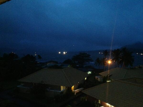
I really don't like how close to the water Jim Edds was. Photo from a couple hours ago when first light broke:
Edit:
He was near Tacloban, just east of it I believe.
https://twitter.com/ExtremeStorms/statu ... 8835072001
Edit:
He was near Tacloban, just east of it I believe.
https://twitter.com/ExtremeStorms/statu ... 8835072001
0 likes
Just a small town southern boy helping other humans.
-
SunnyThoughts
- Category 5
- Posts: 2263
- Joined: Wed Jul 09, 2003 12:42 pm
- Location: Pensacola, Florida

-
SunnyThoughts
- Category 5
- Posts: 2263
- Joined: Wed Jul 09, 2003 12:42 pm
- Location: Pensacola, Florida

-
hurricanes1234
- Category 5
- Posts: 2908
- Joined: Sat Jul 28, 2012 6:19 pm
- Location: Trinidad and Tobago
Re: WPAC: HAIYAN - Typhoon
With the speed this is moving, I'm concerned it'll make it over the water without much weakening. 
0 likes
PLEASE NOTE: With the exception of information from weather agencies that I may copy and paste here, my posts will NEVER be official, since I am NOT a meteorologist. They are solely my amateur opinion, and may or may not be accurate. Therefore, please DO NOT use them as official details, particularly when making important decisions. Thank you.
-
supercane4867
- Category 5
- Posts: 4966
- Joined: Wed Nov 14, 2012 10:43 am

-
South Texas Storms

- Professional-Met

- Posts: 4261
- Joined: Thu Jun 24, 2010 12:28 am
- Location: Houston, TX
-
Aric Dunn
- Category 5
- Posts: 21238
- Age: 43
- Joined: Sun Sep 19, 2004 9:58 pm
- Location: Ready for the Chase.
- Contact:
not good.. I knew once that wind switched
0 likes
Note: If I make a post that is brief. Please refer back to previous posts for the analysis or reasoning. I do not re-write/qoute what my initial post said each time.
If there is nothing before... then just ask
Space & Atmospheric Physicist, Embry-Riddle Aeronautical University,
I believe the sky is falling...
If there is nothing before... then just ask
Space & Atmospheric Physicist, Embry-Riddle Aeronautical University,
I believe the sky is falling...
-
hurricanes1234
- Category 5
- Posts: 2908
- Joined: Sat Jul 28, 2012 6:19 pm
- Location: Trinidad and Tobago
Re: WPAC: HAIYAN - Typhoon
I have an image. Eye is over land.

0 likes
PLEASE NOTE: With the exception of information from weather agencies that I may copy and paste here, my posts will NEVER be official, since I am NOT a meteorologist. They are solely my amateur opinion, and may or may not be accurate. Therefore, please DO NOT use them as official details, particularly when making important decisions. Thank you.
-
supercane4867
- Category 5
- Posts: 4966
- Joined: Wed Nov 14, 2012 10:43 am


Re: WPAC: HAIYAN - Typhoon
hurricanes1234 wrote:I have an image. Eye is over land.
Doesn't look like enough land to cripple it though.
0 likes
NOTICE: I cannot give an expert analysis. Most of my "observations" are made visually with the help of only vital information provided by public advisories.


Re: WPAC: HAIYAN - Typhoon
brunota2003 wrote:I really don't like how close to the water Jim Edds was. Photo from a couple hours ago when first light broke:
Edit:
He was near Tacloban, just east of it I believe.
https://twitter.com/ExtremeStorms/statu ... 8835072001
Not that it matters compared to other things, but, I believe he was in Tacloban, looking east out toward the water, as the city's eastern boundary IS the water. As posted by Edds:
First iPad image looking east over the water Tacloban
0 likes
"Normal" is Chicago under a mile of ice.
-
xtyphooncyclonex

- Category 5
- Posts: 3900
- Age: 24
- Joined: Sat Dec 08, 2012 9:07 am
- Location: Cebu City
- Contact:
Cebu: Also a scary situation...
0 likes
REMINDER: My opinions that I, or any other NON Pro-Met in this forum, are unofficial. Please do not take my opinions as an official forecast and warning. I am NOT a meteorologist. Following my forecasts blindly may lead to false alarm, danger and risk if official forecasts from agencies are ignored.
-
xtyphooncyclonex
- Category 5
- Posts: 3900
- Age: 24
- Joined: Sat Dec 08, 2012 9:07 am
- Location: Cebu City
- Contact:
Pressure here is 986 hPa
0 likes
REMINDER: My opinions that I, or any other NON Pro-Met in this forum, are unofficial. Please do not take my opinions as an official forecast and warning. I am NOT a meteorologist. Following my forecasts blindly may lead to false alarm, danger and risk if official forecasts from agencies are ignored.
-
hurricanes1234
- Category 5
- Posts: 2908
- Joined: Sat Jul 28, 2012 6:19 pm
- Location: Trinidad and Tobago
Re: WPAC: HAIYAN - Typhoon
I know! It already looks like it'll be moving over water within an hour or so. And I'm almost certain those little channels are warm between the islands. Don't think we'll see anything like this on Earth for another decade or more.
0 likes
PLEASE NOTE: With the exception of information from weather agencies that I may copy and paste here, my posts will NEVER be official, since I am NOT a meteorologist. They are solely my amateur opinion, and may or may not be accurate. Therefore, please DO NOT use them as official details, particularly when making important decisions. Thank you.
-
brunota2003
- S2K Supporter
- Posts: 9476
- Age: 35
- Joined: Sat Jul 30, 2005 9:56 pm
- Location: Stanton, KY...formerly Havelock, NC
- Contact:
Re: WPAC: HAIYAN - Typhoon
PaulR wrote:
Not that it matters compared to other things, but, I believe he was in Tacloban, looking east out toward the water, as the city's eastern boundary IS the water. As posted by Edds:First iPad image looking east over the water Tacloban
Yeah, looks like he is in the eastern part of the city, almost right on the beach in a hotel. Not sure how tall the hotel is, a couple stories at least.
0 likes
Just a small town southern boy helping other humans.
-
supercane4867
- Category 5
- Posts: 4966
- Joined: Wed Nov 14, 2012 10:43 am

-
thoughtsinchaos
- Tropical Low

- Posts: 27
- Joined: Thu Sep 09, 2010 4:31 pm
- Location: Los Angeles (UCLA)
- Contact:

Who is online
Users browsing this forum: No registered users and 31 guests