

WDPN32 PGTW 212100
MSGID/GENADMIN/JOINT TYPHOON WRNCEN PEARL HARBOR HI//
SUBJ/PROGNOSTIC REASONING FOR TYPHOON 17W (USAGI) WARNING NR 21//
RMKS/
1. FOR METEOROLOGISTS.
2. 6 HOUR SUMMARY AND ANALYSIS.
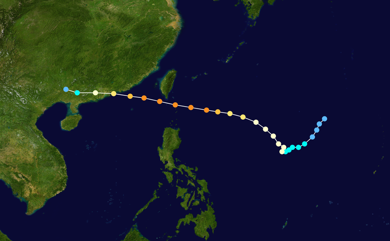
TYPHOON 17W (USAGI), LOCATED APPROXIMATELY 267 NM EAST OF HONG
KONG, HAS TRACKED WEST-NORTHWESTWARD AT 08 KNOTS OVER THE PAST SIX
HOURS. ANIMATED ENHANCED INFRARED SATELLITE IMAGERY (EIR) SHOWS A
STEADY DECLINE IN DEEP SYMMETRIC CONVECTION AROUND THE LOW LEVEL
CIRCULATION CENTER. THE SOUTHERN HALF OF THE SYSTEM REMAINS WELL
DEFINED WITH GOOD EQUATORWARD OUTFLOW, HOWEVER IT APPEARS THE INFLOW
ALONG THE NORTHERN HALF OF THE SYSTEM HAS BEEN IMPACTED OVER THE
PAST SIX HOUR. UPPER LEVEL ANALYSIS INDICATES THE POINT-SOURCE
ANTICYCLONE HAS SHIFTED OVER TOWARDS COASTAL CHINA, TO THE NORTHWEST
OF THE SYSTEM, AND IS CREATING A WEAK PRESSURE GRADIENT ALONG THE
NORTHERN PORTIONS OF TY 17W. THIS INCREASE IN UPPER LEVEL WINDS
ALONG THE NORTHERN HALF OF THE SYSTEM MATCHES UP WITH THE DECREASE
IN CONVECTION OBSERVED IN THE EIR LOOP. THE CYCLONE CONTINUES TO
TRACK ALONG THE SOUTHERN PERIPHERY OF A DEE-LAYERED SUBTROPICAL
RIDGE (STR) TO THE NORTH.
3. FORECAST REASONING.
A. NO CHANGE TO THE FORECAST PHILOSOPHY SINCE THE PREVIOUS
PROGNOSTIC REASONING MESSAGE.
B. TY 17W IS FORECAST TO REMAIN ON A WEST-NORTHWESTWARD TRACK
TOWARDS HONG KONG, AND IS EXPECTED TO MAKE LANDFALL WITHIN THE NEXT
24 TO 30 HOURS. THE DECREASING UPPER LEVEL SUPPORT AND INCREASING
LAND INTERACTIONS WILL KEEP THE SYSTEM ON A STEADY DECLINE THROUGH
LANDFALL. AFTER LANDFALL, THE RAPID DISSIPATION OF THE SYSTEM DUE TO
DISRUPTION OF THE LOW LEVEL INFLOW IS EXPECTED. NUMERIC MODEL
GUIDANCE REMAINS IN TIGHT AGREEMENT, LENDING HIGH
CONFIDENCE TO THE JTWC FORECAST TRACK.//
NNNN


