
ATL: INVEST 95L - Discussion
Moderator: S2k Moderators
-
HurricaneTracker2031
- Tropical Storm

- Posts: 248
- Age: 26
- Joined: Fri Jul 19, 2013 7:20 pm
- Location: Pembroke Pines, FL, USA
- Contact:
This could get very interesting to watch get ready
0 likes
SHORT VERSION OF DISCLAIMER: THIS SITE LINK BELOW IS NOT AN OFFICIAL FORECASTING OFFICE AND SHOULD NOT BE USED TO MAKE ANY EMERGENCY DECISIONS....
http://www.macstropicalweather.weebly.com
http://www.macstropicalweather.weebly.com
-
midnight8

- Tropical Depression

- Posts: 75
- Age: 52
- Joined: Sat Aug 14, 2010 3:05 pm
- Location: Orange, Texas
Re:
Rail Dawg wrote:Until the models start to agree more this will be interesting to watch. I'm not ready by any means to even hazard a guess except to say the surface fuel is there for this thing to pop.
For us here on the Texas Gulf Coast the gas cans have been pulled out of hibernation but not filled yet.
Asked Kerry Cooper local Met if there was a chance of us being impacted in SE TX and he responded with 1 word. "No"
0 likes
KF5KWF Orange, Texas
-
ozonepete
- Professional-Met

- Posts: 4743
- Joined: Mon Sep 07, 2009 3:23 pm
- Location: From Ozone Park, NYC / Now in Brooklyn, NY
Re: ATL: INVEST 95L - Discussion - 70% - 80%
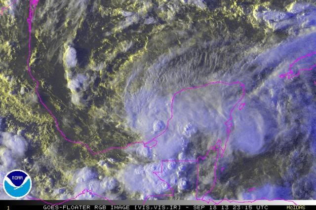
All systems go now. Nice hot tower popping off the coast.

0 likes
-
stormlover2013
Re: ATL: INVEST 95L - Discussion - 70% - 80%
I know coop real well he isn't going to say maybe or yes he will say no untill something finally develops And then go from there
0 likes
-
HurricaneDREW92
- Category 1

- Posts: 320
- Age: 27
- Joined: Sun Jul 28, 2013 11:56 am
- Location: Boston, MA
Re: ATL: INVEST 95L - Discussion - 70% - 80%

0 likes
This post is NOT AN OFFICIAL FORECAST and should not be used as such. It is just the opinion of the poster and may or may not be backed by sound meteorological data. It is NOT endorsed by any professional institution including storm2k.org. For Official Information please refer to the NHC and NWS products.
-THE ABOVE IS THE OPINION OF DREW ONLY
-THE ABOVE IS THE OPINION OF DREW ONLY
-
northjaxpro

- S2K Supporter

- Posts: 8900
- Joined: Mon Sep 27, 2010 11:21 am
- Location: Jacksonville, FL
Yeah, 95L is beginning to fire up. As Ozonepete alluded to above, nice hot tower building near the LLC. I think we will see this named tomorrow easily.
0 likes
NEVER, EVER SAY NEVER in the tropics and weather in general, and most importantly, with life itself!!
________________________________________________________________________________________
Fay 2008 Beryl 2012 Debby 2012 Colin 2016 Hermine 2016 Julia 2016 Matthew 2016 Irma 2017 Dorian 2019
________________________________________________________________________________________
Fay 2008 Beryl 2012 Debby 2012 Colin 2016 Hermine 2016 Julia 2016 Matthew 2016 Irma 2017 Dorian 2019
-
ozonepete
- Professional-Met
- Posts: 4743
- Joined: Mon Sep 07, 2009 3:23 pm
- Location: From Ozone Park, NYC / Now in Brooklyn, NY
Re: ATL: INVEST 95L - Discussion - 70% - 80%
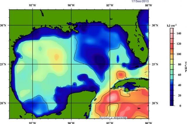
Has a lot of oceanic heat potential ahead of it.

0 likes
I agree with those that contend the system likely won't escape the BOC. I do think a plume of tropical moisture will advect northeastward ahead of the approaching front and deliver solid (and possibly heavy) rains over the southeast US including Florida with nothing west of New Orleans and remain convinced this will be a non event, tropical cyclone speaking, stateside. It certainly could be an issue wherever it eventually lands in Mexico assuming that's the way things play out.
Personal Forecast Disclaimer:
The posts in this forum are NOT official forecast and should not be used as such. They are just the opinion of the poster and may or may not be backed by sound meteorological data. They are NOT endorsed by any professional institution or storm2k.org. For official information, please refer to the NHC and NWS products.
0 likes
-
SFLcane

- S2K Supporter
- Posts: 10281
- Age: 48
- Joined: Sat Jun 05, 2010 1:44 pm
- Location: Lake Worth Florida
Re: ATL: INVEST 95L - Discussion - 70% - 80%
Conditions generally are favorable for the formation of jerry next few days BUT once that trof digs into the gulf it's came over as upper level winds will increase pretty dramatically in the order 40-50kts. jerry is very likely to get entrained into cold front and get strung out . Looks like a rainy system for Florida the way things look to me.
0 likes
Wise men say only fools rush in. 
Personal Forecast Disclaimer:
The posts in this forum are NOT official forecast and should not be used as such. They are just the opinion of the poster and may or may not be backed by sound meteorological data. They are NOT endorsed by any professional institution or storm2k.org. For official information, please refer to the NHC and NWS products.
Last edited by stormkite on Wed Sep 18, 2013 7:49 pm, edited 1 time in total.
0 likes
Re: ATL: INVEST 95L - Discussion - 70% - 80%
TPW
ROLLIN AND TUMBLIN
http://tropic.ssec.wisc.edu/real-time/mimic-tpw/natl/main.html

Uploaded with ImageShack.us
ROLLIN AND TUMBLIN
http://tropic.ssec.wisc.edu/real-time/mimic-tpw/natl/main.html
Uploaded with ImageShack.us
0 likes

Re: ATL: INVEST 95L - Discussion - 70% - 80%
How about this possibility of a track that mirrors a 65 mph tropical storm in 1932.
http://weather.unisys.com/hurricane/atlantic/1932/6/track.gif
http://weather.unisys.com/hurricane/atlantic/1932/6/track.gif
0 likes
-
tropicwatch

- Category 5

- Posts: 3427
- Age: 62
- Joined: Sat Jun 02, 2007 10:01 am
- Location: The Villages, Florida
- Contact:
Re: ATL: INVEST 95L - Discussion - 70% - 80%
ronjon wrote:How about this possibility of a track that mirrors a 65 mph tropical storm in 1932.
http://weather.unisys.com/hurricane/atlantic/1932/6/track.gif
Not out of the realm of possibility. I am not sold on the hanging around in the SW GOM or BOC for a week this time of year. But of course this year has proven to be somewhat unusual with the amount of shear and the difficulty of these systems getting there act together.
0 likes
Tropicwatch
Agnes 72', Eloise 75, Elena 85', Kate 85', Charley 86', Florence 88', Beryl 94', Dean 95', Erin 95', Opal 95', Earl 98', Georges 98', Ivan 2004', Arlene 2005', Dennis 2005', Ida 2009' Debby 2012' Irma 2017' Michael 2018'
Agnes 72', Eloise 75, Elena 85', Kate 85', Charley 86', Florence 88', Beryl 94', Dean 95', Erin 95', Opal 95', Earl 98', Georges 98', Ivan 2004', Arlene 2005', Dennis 2005', Ida 2009' Debby 2012' Irma 2017' Michael 2018'
-
cycloneye

- Admin

- Posts: 149725
- Age: 69
- Joined: Thu Oct 10, 2002 10:54 am
- Location: San Juan, Puerto Rico
Re: ATL: INVEST 95L - Discussion - 70% - 80%
00z Best Track.
AL, 95, 2013091900, , BEST, 0, 203N, 920W, 25, 1004, LO, 34, NEQ, 0, 0, 0, 0, 1008, 180, 100, 0, 0, L, 0, , 0, 0, INVEST, M
AL, 95, 2013091900, , BEST, 0, 203N, 920W, 25, 1004, LO, 34, NEQ, 0, 0, 0, 0, 1008, 180, 100, 0, 0, L, 0, , 0, 0, INVEST, M
0 likes
Visit the Caribbean-Central America Weather Thread where you can find at first post web cams,radars
and observations from Caribbean basin members Click Here
and observations from Caribbean basin members Click Here
-
wxman57

- Moderator-Pro Met

- Posts: 23175
- Age: 68
- Joined: Sat Jun 21, 2003 8:06 pm
- Location: Houston, TX (southwest)
Re: ATL: INVEST 95L - Discussion - 70% - 80%
I'm still thinking about 99.999999% Jerry by tomorrow afternoon. Probably stays a TS. Moves to near Tampico Friday evening, stalls, then drifts south as the front approaches and sends dry air down the coast of MX. Tracks SE into northern BoC then NE-ENE along front toward Florida. May not be much of a storm by the time it arrives in FL, though. Could completely merge with the front by then.
0 likes
-
HurricaneDREW92
- Category 1
- Posts: 320
- Age: 27
- Joined: Sun Jul 28, 2013 11:56 am
- Location: Boston, MA
Re: ATL: INVEST 95L - Discussion - 70% - 80%
wxman57 wrote:I'm still thinking about 99.999999% Jerry by tomorrow afternoon. Probably stays a TS. Moves to near Tampico Friday evening, stalls, then drifts south as the front approaches and sends dry air down the coast of MX. Tracks SE into northern BoC then NE-ENE along front toward Florida. May not be much of a storm by the time it arrives in FL, though. Could completely merge with the front by then.
not likely 2 b a TS ANYTIME soon. maybe in the 120hr frame
0 likes
This post is NOT AN OFFICIAL FORECAST and should not be used as such. It is just the opinion of the poster and may or may not be backed by sound meteorological data. It is NOT endorsed by any professional institution including storm2k.org. For Official Information please refer to the NHC and NWS products.
-THE ABOVE IS THE OPINION OF DREW ONLY
-THE ABOVE IS THE OPINION OF DREW ONLY
Re: ATL: INVEST 95L - Discussion - 70% - 80%
HurricaneDREW92 wrote:wxman57 wrote:I'm still thinking about 99.999999% Jerry by tomorrow afternoon. Probably stays a TS. Moves to near Tampico Friday evening, stalls, then drifts south as the front approaches and sends dry air down the coast of MX. Tracks SE into northern BoC then NE-ENE along front toward Florida. May not be much of a storm by the time it arrives in FL, though. Could completely merge with the front by then.
not likely 2 b a TS ANYTIME soon. maybe in the 120hr frame
Why do you say that, Drew? NHL says 70% Chance that it is well before the 120 hour frame.
0 likes
I'm no expert, everything I say should be taken with a large amount of salt. I could easily be very, very wrong.
~Zanthe Go Coyotes~
~Zanthe Go Coyotes~
-
ozonepete
- Professional-Met
- Posts: 4743
- Joined: Mon Sep 07, 2009 3:23 pm
- Location: From Ozone Park, NYC / Now in Brooklyn, NY
Re: ATL: INVEST 95L - Discussion - 70% - 80%
HurricaneDREW92 wrote:wxman57 wrote:I'm still thinking about 99.999999% Jerry by tomorrow afternoon. Probably stays a TS. Moves to near Tampico Friday evening, stalls, then drifts south as the front approaches and sends dry air down the coast of MX. Tracks SE into northern BoC then NE-ENE along front toward Florida. May not be much of a storm by the time it arrives in FL, though. Could completely merge with the front by then.
not likely 2 b a TS ANYTIME soon. maybe in the 120hr frame
What data are you basing that on?
0 likes
Re: ATL: INVEST 95L - Discussion - 70% - 80%
wxman57 wrote:I'm still thinking about 99.999999% Jerry by tomorrow afternoon. Probably stays a TS. Moves to near Tampico Friday evening, stalls, then drifts south as the front approaches and sends dry air down the coast of MX. Tracks SE into northern BoC then NE-ENE along front toward Florida. May not be much of a storm by the time it arrives in FL, though. Could completely merge with the front by then.
that sounds like a very reasonable scenario. the system looks like it's developing right now with deep convection bursting and impressive outflow. a renumber within the next 12 hours seems probable at this point.
0 likes

Re: ATL: INVEST 95L - Discussion - 70% - 80%
wxman57 wrote:I'm still thinking about 99.999999% Jerry by tomorrow afternoon. Probably stays a TS. Moves to near Tampico Friday evening, stalls, then drifts south as the front approaches and sends dry air down the coast of MX. Tracks SE into northern BoC then NE-ENE along front toward Florida. May not be much of a storm by the time it arrives in FL, though. Could completely merge with the front by then.
I agree there is nothing to keep this down in the short term and in the long term it will be quite hard for it to maintain its structure with the front screaming across the gulf. The models are just having a hard time with the interaction with the front.
0 likes
The following post is NOT an official forecast and should not be used as such. It is just the opinion of the poster and may or may not be backed by sound meteorological data. It is NOT endorsed by any professional institution including storm2k.org For Official Information please refer to the NHC and NWS products.
Who is online
Users browsing this forum: No registered users and 68 guests