I think le Berto will reach 120ish knots. He might be eating dusty air at the moment but he has the time to restrengthen...?
This post is NOT AN OFFICIAL FORECAST and should not be used as such. It is just the opinion of the poster and may or may not be backed by sound meteorological data. It is NOT endorsed by any professional institution including storm2k.org. For Official Information please refer to the NHC and NWS products.
ATL: HUMBERTO - Remnants - Discussion
Moderator: S2k Moderators
-
TropicalAnalystwx13

- Category 5

- Posts: 2109
- Age: 28
- Joined: Tue Jul 19, 2011 8:20 pm
- Location: Wilmington, NC
- Contact:
Humberto has about 12 more hours to intensify before getting into cooler waters and a high shear environment. The fat lady isn't singing yet though. After 120 hours, there are indications that the system will get into warmer waters again and embed itself within a low shear environment. Both the GFS and ECMWF show re-intensification into a hurricane, and in fact, the ECMWF makes it a 972mb hurricane!
0 likes
-
cycloneye

- Admin

- Posts: 149677
- Age: 69
- Joined: Thu Oct 10, 2002 10:54 am
- Location: San Juan, Puerto Rico
Re: ATL: HUMBERTO - Hurricane - Discussion
SUMMARY OF 500 PM AST...2100 UTC...INFORMATION
----------------------------------------------
LOCATION...18.0N 29.0W
ABOUT 360 MI...575 KM WNW OF THE CAPE VERDE ISLANDS
MAXIMUM SUSTAINED WINDS...85 MPH...140 KM/H
PRESENT MOVEMENT...N OR 350 DEGREES AT 12 MPH...19 KM/H
MINIMUM CENTRAL PRESSURE...986 MB...29.12 INCHES
Read 5 PM Discussion here.
----------------------------------------------
LOCATION...18.0N 29.0W
ABOUT 360 MI...575 KM WNW OF THE CAPE VERDE ISLANDS
MAXIMUM SUSTAINED WINDS...85 MPH...140 KM/H
PRESENT MOVEMENT...N OR 350 DEGREES AT 12 MPH...19 KM/H
MINIMUM CENTRAL PRESSURE...986 MB...29.12 INCHES
Read 5 PM Discussion here.
0 likes
Visit the Caribbean-Central America Weather Thread where you can find at first post web cams,radars
and observations from Caribbean basin members Click Here
and observations from Caribbean basin members Click Here

Re:
TropicalAnalystwx13 wrote:Humberto has about 12 more hours to intensify before getting into cooler waters and a high shear environment. The fat lady isn't singing yet though. After 120 hours, there are indications that the system will get into warmer waters again and embed itself within a low shear environment. Both the GFS and ECMWF show re-intensification into a hurricane, and in fact, the ECMWF makes it a 972mb hurricane!
gotta wonder if that plays out what the real-time intensity would be, as the Euro tends to be a little high on pressure.
0 likes
The above post is not official and should not be used as such. It is the opinion of the poster and may or may not be backed by sound meteorological data. It is not endorsed by any professional institution or storm2k.org. For official information, please refer to the NHC and NWS products.
-
ozonepete
- Professional-Met

- Posts: 4743
- Joined: Mon Sep 07, 2009 3:23 pm
- Location: From Ozone Park, NYC / Now in Brooklyn, NY
Re: ATL: HUMBERTO - Hurricane - Discussion
Hmmm. Convection building with colder cloud tops even though it's at DMIN. Certainly makes more strengthening more likely. Has really grown in size as well which helps keep dry air out.
0 likes
Re: ATL: HUMBERTO - Hurricane - Discussion
Interesting comparison between yesterday and today to show just how much things can change in 24 hours.
http://rammb.cira.colostate.edu/products/tc_realtime/products/storms/2013AL09/4KMIRIMG/2013AL09_4KMIRIMG_201309102130.GIF
http://rammb.cira.colostate.edu/products/tc_realtime/products/storms/2013AL09/4KMIRIMG/2013AL09_4KMIRIMG_201309112045.GIF
http://rammb.cira.colostate.edu/products/tc_realtime/products/storms/2013AL09/4KMIRIMG/2013AL09_4KMIRIMG_201309102130.GIF
http://rammb.cira.colostate.edu/products/tc_realtime/products/storms/2013AL09/4KMIRIMG/2013AL09_4KMIRIMG_201309112045.GIF
0 likes
The above post is not official and should not be used as such. It is the opinion of the poster and may or may not be backed by sound meteorological data. It is not endorsed by any professional institution or storm2k.org. For official information, please refer to the NHC and NWS products.
-
ozonepete
- Professional-Met
- Posts: 4743
- Joined: Mon Sep 07, 2009 3:23 pm
- Location: From Ozone Park, NYC / Now in Brooklyn, NY
Re: ATL: HUMBERTO - Hurricane - Discussion
Biggest, strongest TC of the season so far. A lot of convection for DMIN time.


0 likes
-
HurricaneDREW92
- Category 1

- Posts: 320
- Age: 27
- Joined: Sun Jul 28, 2013 11:56 am
- Location: Boston, MA
Re: ATL: HUMBERTO - Hurricane - Discussion
Storm parades north...what a beauty


0 likes
This post is NOT AN OFFICIAL FORECAST and should not be used as such. It is just the opinion of the poster and may or may not be backed by sound meteorological data. It is NOT endorsed by any professional institution including storm2k.org. For Official Information please refer to the NHC and NWS products.
-THE ABOVE IS THE OPINION OF DREW ONLY
-THE ABOVE IS THE OPINION OF DREW ONLY
-
ozonepete
- Professional-Met
- Posts: 4743
- Joined: Mon Sep 07, 2009 3:23 pm
- Location: From Ozone Park, NYC / Now in Brooklyn, NY
Re: ATL: HUMBERTO - Hurricane - Discussion

0 likes
-
Gustywind

- Category 5
- Posts: 12334
- Joined: Mon Sep 03, 2007 7:29 am
- Location: Baie-Mahault, GUADELOUPE
Re: ATL: HUMBERTO - Hurricane - Discussion
ozonepete wrote::uarrow: Yeah. Has consistently held on to nice closed banding. Keeps the dry air out. And there's two more strong waves behind it.
Is that a sign that things could heating up during the next couple of days?

0 likes
-
northjaxpro

- S2K Supporter

- Posts: 8900
- Joined: Mon Sep 27, 2010 11:21 am
- Location: Jacksonville, FL
Well, Mother Nature made us wait seemingly forever, but she has finally given us a full fledged hurricane to track in the Atlantic basin.
Humberto has become a large and rather formidable tropical cyclone. It looks as if will be around for quite some time to come. I will be interested to see what happens in about 5 days after the storm finishes traverses over cooler SSTs and moves into the Central Atlantic.
Humberto has become a large and rather formidable tropical cyclone. It looks as if will be around for quite some time to come. I will be interested to see what happens in about 5 days after the storm finishes traverses over cooler SSTs and moves into the Central Atlantic.
0 likes
NEVER, EVER SAY NEVER in the tropics and weather in general, and most importantly, with life itself!!
________________________________________________________________________________________
Fay 2008 Beryl 2012 Debby 2012 Colin 2016 Hermine 2016 Julia 2016 Matthew 2016 Irma 2017 Dorian 2019
________________________________________________________________________________________
Fay 2008 Beryl 2012 Debby 2012 Colin 2016 Hermine 2016 Julia 2016 Matthew 2016 Irma 2017 Dorian 2019
-
hurricanes1234
- Category 5
- Posts: 2908
- Joined: Sat Jul 28, 2012 6:19 pm
- Location: Trinidad and Tobago
Re: ATL: HUMBERTO - Hurricane - Discussion
Storm parades north...what a beauty
What does this mean?
0 likes
PLEASE NOTE: With the exception of information from weather agencies that I may copy and paste here, my posts will NEVER be official, since I am NOT a meteorologist. They are solely my amateur opinion, and may or may not be accurate. Therefore, please DO NOT use them as official details, particularly when making important decisions. Thank you.
-
ozonepete
- Professional-Met
- Posts: 4743
- Joined: Mon Sep 07, 2009 3:23 pm
- Location: From Ozone Park, NYC / Now in Brooklyn, NY
Re: ATL: HUMBERTO - Hurricane - Discussion
Gustywind wrote:ozonepete wrote::uarrow: Yeah. Has consistently held on to nice closed banding. Keeps the dry air out. And there's two more strong waves behind it.
Is that a sign that things could heating up during the next couple of days?
Looks that way, gusty. All of the global models have a TS in the western GOM this weekend (NAVGEM has a hurricane) and something coming off of Africa early next week. Looks like the heart of the season is starting to fire.
0 likes
-
Gustywind
- Category 5
- Posts: 12334
- Joined: Mon Sep 03, 2007 7:29 am
- Location: Baie-Mahault, GUADELOUPE
Re: ATL: HUMBERTO - Hurricane - Discussion
ozonepete wrote:Gustywind wrote:ozonepete wrote::uarrow: Yeah. Has consistently held on to nice closed banding. Keeps the dry air out. And there's two more strong waves behind it.
Is that a sign that things could heating up during the next couple of days?
Looks that way, gusty. All of the global models have a TS in the western GOM this weekend (NAVGEM has a hurricane) and something coming off of Africa early next week. Looks like the heart of the season is starting to fire.
Looks like , given your statement, agree with that. After a "strange short lull", things are changing now. Thanks for these nice infos Ozonepete (as usual). I think that Cycloneye and the others carib friends, monitor closely all these twaves as IMO any feature could be a potential threat for any land mass area .... as we're in the peak of the season. Let's wait an see...
0 likes
-
Caribwxgirl
- S2K Supporter
- Posts: 287
- Joined: Mon Aug 15, 2011 7:25 pm
- Location: Budapest, Hungary (from Kingston, Jamaica)
Re: ATL: HUMBERTO - Hurricane - Discussion
Hammy wrote:Interesting comparison between yesterday and today to show just how much things can change in 24 hours.
http://rammb.cira.colostate.edu/products/tc_realtime/products/storms/2013AL09/4KMIRIMG/2013AL09_4KMIRIMG_201309102130.GIF
http://rammb.cira.colostate.edu/products/tc_realtime/products/storms/2013AL09/4KMIRIMG/2013AL09_4KMIRIMG_201309112045.GIF
Excellent comparison what a difference a day makes.
0 likes
Personal Forecast Disclaimer:
The posts in this forum are NOT official forecast. They are just the opinion of the poster and may or may not be backed by sound meteorological data. They are NOT endorsed by any professional institutions or storm2k.org. For official information refer to the NHC and NWS products.
The posts in this forum are NOT official forecast. They are just the opinion of the poster and may or may not be backed by sound meteorological data. They are NOT endorsed by any professional institutions or storm2k.org. For official information refer to the NHC and NWS products.
-
ozonepete
- Professional-Met
- Posts: 4743
- Joined: Mon Sep 07, 2009 3:23 pm
- Location: From Ozone Park, NYC / Now in Brooklyn, NY
Re: ATL: HUMBERTO - Hurricane - Discussion
Watch the satellite loops - dry air is getting pulled in on the outermost western side of the circulation. Not so sure the circulation envelope will keep it out tonight.
0 likes
-
TheStormExpert
Re: ATL: HUMBERTO - Hurricane - Discussion
ozonepete wrote:Biggest, strongest TC of the season so far. A lot of convection for DMIN time.
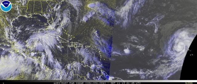
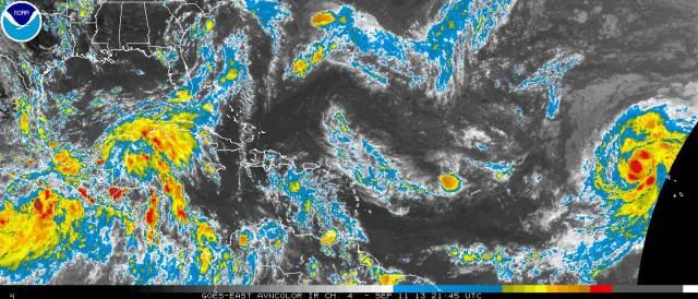
http://i189.photobucket.com/albums/z174/philnyc_2007/sattroprgb2013-09-112145_zps770e5357.jpg
http://i189.photobucket.com/albums/z174/philnyc_2007/sattropavn2013-09-112145_zpsde2a14aa.jpg
Hurricane Humberto is definitely bigger in size than Texas!
0 likes
-
TheStormExpert
Re:
northjaxpro wrote:Well, Mother Nature made us wait seemingly forever, but she has finally given us a full fledged hurricane to track in the Atlantic basin.
Humberto has become a large and rather formidable tropical cyclone. It looks as if will be around for quite some time to come. I will be interested to see what happens in about 5 days after the storm finishes traverses over cooler SSTs and moves into the Central Atlantic.
Maybe mother nature saved the best for last this season.
0 likes
Who is online
Users browsing this forum: No registered users and 66 guests