
Looking at the posted forecasted track, it looks like it will head due west around 25N. What happens if it continues
on that path which looks like it heads to northern Florida?
ATL: HUMBERTO - Remnants - Discussion
Moderator: S2k Moderators
-
ozonepete
- Professional-Met

- Posts: 4743
- Joined: Mon Sep 07, 2009 3:23 pm
- Location: From Ozone Park, NYC / Now in Brooklyn, NY
Re: ATL: HUMBERTO - Tropical Storm - Discussion
hipshot wrote:Looking at the posted forecasted track, it looks like it will head due west around 25N. What happens if it continues
on that path which looks like it heads to northern Florida?
No way of knowing at all. Way too far out in time.
0 likes
-
ozonepete
- Professional-Met
- Posts: 4743
- Joined: Mon Sep 07, 2009 3:23 pm
- Location: From Ozone Park, NYC / Now in Brooklyn, NY
Re: ATL: HUMBERTO - Tropical Storm - Discussion
hurricanes1234 wrote:So then this means that Humberto could stop just 4 mph before hurricane strength?!
The posts in this forum are NOT official forecast and should not be used as such. They are just the opinion of the poster and may or may not be backed by sound meteorological data. They are NOT endorsed by any professional institution or storm2k.org. For official information, please refer to the NHC and NWS products.
Ha ha anything's possible but D-MAX hasn't even started yet.
0 likes
-
HurricaneDREW92
- Category 1

- Posts: 320
- Age: 27
- Joined: Sun Jul 28, 2013 11:56 am
- Location: Boston, MA
Re: ATL: HUMBERTO - Tropical Storm - Discussion

0 likes
This post is NOT AN OFFICIAL FORECAST and should not be used as such. It is just the opinion of the poster and may or may not be backed by sound meteorological data. It is NOT endorsed by any professional institution including storm2k.org. For Official Information please refer to the NHC and NWS products.
-THE ABOVE IS THE OPINION OF DREW ONLY
-THE ABOVE IS THE OPINION OF DREW ONLY
-
TropicalAnalystwx13

- Category 5

- Posts: 2109
- Age: 28
- Joined: Tue Jul 19, 2011 8:20 pm
- Location: Wilmington, NC
- Contact:


Re: ATL: HUMBERTO - Tropical Storm - Discussion

http://tropic.ssec.wisc.edu/
Uploaded with ImageShack.us
Personal Forecast Disclaimer:
The posts in this forum are NOT official forecast and should not be used as such. They are just the opinion of the poster and may or may not be backed by sound meteorological data. They are NOT endorsed by any professional institution or storm2k.org. For official information, please refer to the NHC and NWS products.
0 likes
-
TheStormExpert
-
cycloneye

- Admin

- Posts: 149719
- Age: 69
- Joined: Thu Oct 10, 2002 10:54 am
- Location: San Juan, Puerto Rico
Re: ATL: HUMBERTO - Tropical Storm - Discussion
Oh boy.

0 likes
Visit the Caribbean-Central America Weather Thread where you can find at first post web cams,radars
and observations from Caribbean basin members Click Here
and observations from Caribbean basin members Click Here
-
tolakram
- Admin
- Posts: 20186
- Age: 62
- Joined: Sun Aug 27, 2006 8:23 pm
- Location: Florence, KY (name is Mark)
Re: ATL: HUMBERTO - Tropical Storm - Discussion
While this looks like attack of the 2013's I can't help but remember tat the most recent run of the Euro still shows a fairly strong system in 24 to 48 hours.  We shall see. A bust would be most interesting, hard not to root for one.
0 likes
M a r k
- - - - -
Join us in chat: Storm2K Chatroom Invite. Android and IOS apps also available.
The posts in this forum are NOT official forecasts and should not be used as such. Posts are NOT endorsed by any professional institution or STORM2K.org. For official information and forecasts, please refer to NHC and NWS products.
-
WeatherGuesser
- Category 5
- Posts: 2672
- Joined: Tue Jun 29, 2010 6:46 am
-
TheStormExpert
-
hurricanes1234
- Category 5
- Posts: 2908
- Joined: Sat Jul 28, 2012 6:19 pm
- Location: Trinidad and Tobago
Re:
WeatherGuesser wrote:Y'all tryin' to say it appears to be fallin' apart?
Yes, basically. I am still in shock, but then again, it's 2013 in ALL basins. Would be sad if this was pulling an Erin at this advanced stage of tropical storm strength.
The posts in this forum are NOT official forecast and should not be used as such. They are just the opinion of the poster and may or may not be backed by sound meteorological data. They are NOT endorsed by any professional institution or storm2k.org. For official information, please refer to the NHC and NWS products.
0 likes
PLEASE NOTE: With the exception of information from weather agencies that I may copy and paste here, my posts will NEVER be official, since I am NOT a meteorologist. They are solely my amateur opinion, and may or may not be accurate. Therefore, please DO NOT use them as official details, particularly when making important decisions. Thank you.
-
WilmingtonSandbar
- S2K Supporter

- Posts: 505
- Joined: Sun Aug 29, 2010 12:11 pm
- Location: Southport, NC
Re: ATL: HUMBERTO - Tropical Storm - Discussion
TheStormExpert wrote:
What do you mean by "Oh boy"?
Maybe he means, "It looks like dry air is wrapping into the center, and this might be falling apart rather quickly. Oh boy."
0 likes
Diana X2 (look it up), Bertha, Fran, Bonnie, Floyd, Dennis, Charley, Ophelia, Ernesto, Irene, Matthew, And Florence
-
ozonepete
- Professional-Met
- Posts: 4743
- Joined: Mon Sep 07, 2009 3:23 pm
- Location: From Ozone Park, NYC / Now in Brooklyn, NY
Re: ATL: HUMBERTO - Tropical Storm - Discussion
cycloneye wrote:Oh boy.
A couple of things. The arc of clouds to the west and north show a shield of the circulation envelope that will prevent it from ingesting any more dry air than it has, and it's not clear at all how much it has ingested since it is at DMIN. The inflow from the south and east is quite moist.
It lost symmetry today as it started to recurve but seems to be regaining very good banding and symmetry again.
An eye-feature is still apparent at low to mid-levels.
Luis you may get your annular hurricane after all.
0 likes
-
hurricanes1234
- Category 5
- Posts: 2908
- Joined: Sat Jul 28, 2012 6:19 pm
- Location: Trinidad and Tobago
Re: ATL: HUMBERTO - Tropical Storm - Discussion
Are you sure? How do you know if an annular hurricane is on the way?
0 likes
PLEASE NOTE: With the exception of information from weather agencies that I may copy and paste here, my posts will NEVER be official, since I am NOT a meteorologist. They are solely my amateur opinion, and may or may not be accurate. Therefore, please DO NOT use them as official details, particularly when making important decisions. Thank you.
-
ozonepete
- Professional-Met
- Posts: 4743
- Joined: Mon Sep 07, 2009 3:23 pm
- Location: From Ozone Park, NYC / Now in Brooklyn, NY
Re: ATL: HUMBERTO - Tropical Storm - Discussion
hurricanes1234 wrote:Are you sure? How do you know if an annular hurricane is on the way?
Don't at all. It was a partial joke, but look at the next post I'm going to do.
0 likes
-
ozonepete
- Professional-Met
- Posts: 4743
- Joined: Mon Sep 07, 2009 3:23 pm
- Location: From Ozone Park, NYC / Now in Brooklyn, NY
Re: ATL: HUMBERTO - Tropical Storm - Discussion
Multiple concentric convective bands. You could easily argue that the later image looks more like a hurricane than the first one. The amount of convection at the core is not the only influence and factor in whether a TC is a hurricane. Structure is very important. It's a real shame we can't get recon there...
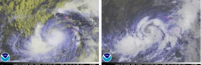
CIMSS ADT numbers going up again btw.

CIMSS ADT numbers going up again btw.
Last edited by ozonepete on Tue Sep 10, 2013 7:22 pm, edited 1 time in total.
0 likes
-
TropicalAnalystwx13
- Category 5
- Posts: 2109
- Age: 28
- Joined: Tue Jul 19, 2011 8:20 pm
- Location: Wilmington, NC
- Contact:
Re: ATL: HUMBERTO - Tropical Storm - Discussion
ozonepete wrote:Multiple concentric convective bands. You could easily argue that the later image looks more like a hurricane than the first one. The amount of convection at the core is not the only influence and factor in whether a TC is a hurricane. Structure is very important. It's a real shame we can't get recon there...
NHC is heavily reliant on satellite intensity estimates for systems in the East Atlantic though and the strength of a system -- at least according to the Dvorak technique -- is determined a good deal by the amount of central convection. I do agree it's borderline right now. Hopefully DMAX fixes it, I want to see a hurricane sometime soon.
0 likes
Who is online
Users browsing this forum: No registered users and 44 guests