hurricanes1234 wrote:Is the following statement somewhat realistic?
Humberto could begin to rapidly intensify tonight or tomorrow.
It's in the realm of possibility. If it stacks up overnight it has a very good chance to RI.
Moderator: S2k Moderators

hurricanes1234 wrote:Is the following statement somewhat realistic?
Humberto could begin to rapidly intensify tonight or tomorrow.

ozonepete wrote:hurricanes1234 wrote:Is the following statement somewhat realistic?
Humberto could begin to rapidly intensify tonight or tomorrow.
It's in the realm of possibility. If it stacks up overnight it has a very good chance to RI.


cycloneye wrote:Moving West to Westsouthwest? Or is only an ilusion on my part? Saved loop.

galaxy401 wrote:cycloneye wrote:Moving West to Westsouthwest? Or is only an ilusion on my part? Saved loop.
I think it's just the convection moving southwest of the center. A recent microwave pass did show the convection southwest of the center compared to just west of it.

hurricaneCW wrote:galaxy401 wrote:cycloneye wrote:Moving West to Westsouthwest? Or is only an ilusion on my part? Saved loop.
I think it's just the convection moving southwest of the center. A recent microwave pass did show the convection southwest of the center compared to just west of it.
The center could very well relocate closer to the deep convection, so a SW relocation wouldn't surprise me. In fact it's very common in developing tropical systems so long as the shear isn't too overpowering. A relocation further south would give it more time in a favorable environment so the intensity could be a lot higher than forecast.


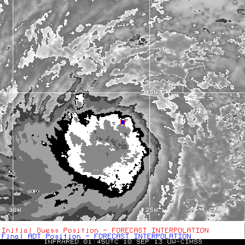
TropicalAnalystwx13 wrote:CIMSS-ADT says the center is becoming increasingly embedded within the central dense overcast. Final T# up to T3.0/45kt; raw up to T3.2.

TropicalAnalystwx13 wrote:ozonepete wrote::uarrow: Thanks, T13. So all of our data agree on the center location. It is gradually getting under the convection as forecast. With the very low shear ahead of it and dry air remaining north of it until Thursday this has very good conditions for strengthening.
Yep. I wouldn't be surprised to see a period of rapid intensification once an inner core becomes established either. The GFS seems to indicate this.
Makes sense...the storm is embedded within a large and deep moisture bubble. Relative humidity values as analyzed by SHIPS are above 75%. Dry air certainly not an issue.

TheStormExpert wrote:But it is supposed to be making that sharp north turn which looks to be where the bulk of this mid-level dry air is?


Users browsing this forum: No registered users and 52 guests