ATL: GABRIELLE - Remnants - Discussion

Moderator: S2k Moderators

Message
Author
User avatar
pgoss11
Category 2
Category 2
Posts: 702
Joined: Tue Sep 02, 2003 3:55 pm

Re: ATL: INVEST 97L - Discussion

#481 Postby pgoss11 » Mon Sep 02, 2013 6:16 pm

Hybridstorm_November2001 wrote:Just found this about the so called 'Newfoundland Wheel' -

http://www.examiner.com/article/summer-2010-what-are-ocean-temperatures-indicating


Honestly I had never heard that term before today but it is interesting..
0 likes   

User avatar
gatorcane
S2K Supporter
S2K Supporter
Posts: 23691
Age: 47
Joined: Sun Mar 13, 2005 3:54 pm
Location: Boca Raton, FL

Re: ATL: INVEST 97L - Discussion

#482 Postby gatorcane » Mon Sep 02, 2013 6:17 pm

cycloneye wrote:New Video about 97L by Levi Cowan.

http://www.tropicaltidbits.com/blog/201 ... -antilles/

This post is NOT AN OFFICIAL FORECAST and should not be used as such. It is just the opinion of the poster and may or may not be backed by sound meteorological data. It is NOT endorsed by any professional institution including storm2k.org. For Official Information please refer to the NHC and NWS products.

He is leaning more with the UKMET/ECMWF which brings the system towards Cuba in 5 days (graphic below).

Mentions alot of rainfall potential for the Caribbean islands including Leewards, Puerto Rico, and Hispaniola.

Image

The posts in this forum are NOT official forecast and should not be used as such. They are just the opinion of the poster and may or may not be backed by sound meteorological data. They are NOT endorsed by any professional institution or storm2k.org. For official information, please refer to the NHC and NWS products.
0 likes   

User avatar
cycloneye
Admin
Admin
Posts: 145322
Age: 68
Joined: Thu Oct 10, 2002 10:54 am
Location: San Juan, Puerto Rico

Re: ATL: INVEST 97L - Discussion

#483 Postby cycloneye » Mon Sep 02, 2013 6:35 pm

No change.20%-50%

AN ELONGATED AREA OF LOW PRESSURE IS PRODUCING DISORGANIZED SHOWERS
AND THUNDERSTORMS FROM THE EASTERN CARIBBEAN SEA ACROSS THE LESSER
ANTILLES AND INTO THE TROPICAL ATLANTIC. ALTHOUGH UPPER-LEVEL WINDS
ARE CONDUCIVE...THE BROAD NATURE OF THIS DISTURBANCE AND THE
PROXIMITY OF DRY AIR IN THE MIDDLE LEVELS OF THE ATMOSPHERE HAVE
BEEN INHIBITING DEVELOPMENT. CONDITIONS COULD GRADUALLY BECOME
MORE CONDUCIVE FOR DEVELOPMENT WHILE THE SYSTEM MOVES WEST-
NORTHWESTWARD AT AROUND 10 MPH NEAR PUERTO RICO AND HISPANIOLA IN
THE NEXT SEVERAL DAYS. THIS SYSTEM HAS A LOW CHANCE...20
PERCENT...OF BECOMING A TROPICAL CYCLONE DURING THE NEXT 48
HOURS...AND A MEDIUM CHANCE...50 PERCENT...OF BECOMING A TROPICAL
CYCLONE DURING THE NEXT 5 DAYS. REGARDLESS OF TROPICAL CYCLONE
FORMATION...LOCALLY HEAVY RAINFALL AND GUSTY WINDS ARE EXPECTED TO
AFFECT PORTIONS OF THE LESSER ANTILLES OVER THE NEXT DAY OR TWO.

0 likes   
Visit the Caribbean-Central America Weather Thread where you can find at first post web cams,radars
and observations from Caribbean basin members Click Here

User avatar
SFLcane
S2K Supporter
S2K Supporter
Posts: 10163
Age: 47
Joined: Sat Jun 05, 2010 1:44 pm
Location: Lake Worth Florida

Re: ATL: INVEST 97L - Discussion

#484 Postby SFLcane » Mon Sep 02, 2013 7:26 pm

Wxman57, i see you on..latest thoughts on invest 97? Might it miss that trof and head back west near the bahamas.
0 likes   

User avatar
cycloneye
Admin
Admin
Posts: 145322
Age: 68
Joined: Thu Oct 10, 2002 10:54 am
Location: San Juan, Puerto Rico

Re: ATL: INVEST 97L - Discussion

#485 Postby cycloneye » Mon Sep 02, 2013 7:37 pm

00z Best Track.

AL, 97, 2013090300, , BEST, 0, 143N, 605W, 25, 1009, LO
0 likes   
Visit the Caribbean-Central America Weather Thread where you can find at first post web cams,radars
and observations from Caribbean basin members Click Here

floridasun78
Category 5
Category 5
Posts: 3755
Joined: Sun May 17, 2009 10:16 pm
Location: miami fl

Re: ATL: INVEST 97L - Discussion

#486 Postby floridasun78 » Mon Sep 02, 2013 7:49 pm

cycloneye wrote:00z Best Track.

AL, 97, 2013090300, , BEST, 0, 143N, 605W, 25, 1009, LO

not weak low
0 likes   

User avatar
cycloneye
Admin
Admin
Posts: 145322
Age: 68
Joined: Thu Oct 10, 2002 10:54 am
Location: San Juan, Puerto Rico

Re: ATL: INVEST 97L - Discussion

#487 Postby cycloneye » Mon Sep 02, 2013 8:49 pm

Good radar presentation. It appears Low center is between Martinique and Dominica

Image
0 likes   
Visit the Caribbean-Central America Weather Thread where you can find at first post web cams,radars
and observations from Caribbean basin members Click Here

User avatar
NDG
S2K Supporter
S2K Supporter
Posts: 15446
Joined: Sun Jul 09, 2006 10:14 pm
Location: Orlando, FL

Re: ATL: INVEST 97L - Discussion

#488 Postby NDG » Mon Sep 02, 2013 8:56 pm

cycloneye wrote:Good radar presentation. It appears Low center is between Martinique and Dominica

http://oi44.tinypic.com/2mo9yeo.jpg


Pressure readings coincide with the radar loop image, lowest pressures are found in Martinique and Dominica this evening.
0 likes   

User avatar
Hammy
Category 5
Category 5
Posts: 5849
Age: 41
Joined: Fri May 25, 2012 5:25 pm
Contact:

#489 Postby Hammy » Mon Sep 02, 2013 9:20 pm

doesn't seem to have quite the well defined rotation this evening, but despite that it looks like convergence is increasing.
0 likes   
The above post is not official and should not be used as such. It is the opinion of the poster and may or may not be backed by sound meteorological data. It is not endorsed by any professional institution or storm2k.org. For official information, please refer to the NHC and NWS products.

EastCoastlow

Re: ATL: INVEST 97L - Discussion

#490 Postby EastCoastlow » Mon Sep 02, 2013 9:21 pm

This invest has the most Interesting model scenarios.

http://www.atmos.albany.edu/facstaff/tang/tcguidance/
0 likes   

ozonepete
Professional-Met
Professional-Met
Posts: 4743
Joined: Mon Sep 07, 2009 3:23 pm
Location: From Ozone Park, NYC / Now in Brooklyn, NY

Re: ATL: INVEST 97L - Discussion

#491 Postby ozonepete » Mon Sep 02, 2013 9:23 pm

Very odd out there. There are clearly two disturbances going on and obviously they can't share energy forever. I really can't say much else, other than that in a case like this you trust the models to reconcile it since they have a lot of "experience" programmed into them now. So the sooner the lagging disturbance dies out the sooner the leading one will intensify.

Image
0 likes   

floridasun78
Category 5
Category 5
Posts: 3755
Joined: Sun May 17, 2009 10:16 pm
Location: miami fl

#492 Postby floridasun78 » Mon Sep 02, 2013 9:26 pm

i see few want go up hurr but look like wont be hurr the way going
0 likes   

User avatar
cycloneye
Admin
Admin
Posts: 145322
Age: 68
Joined: Thu Oct 10, 2002 10:54 am
Location: San Juan, Puerto Rico

Re: ATL: INVEST 97L - Discussion

#493 Postby cycloneye » Mon Sep 02, 2013 9:47 pm

Late night update from the San Juan NWS.

AREA FORECAST DISCUSSION
NATIONAL WEATHER SERVICE SAN JUAN PR
1039 PM AST MON SEP 2 2013

.UPDATE...DELAYED THE ONSET OF WIDESPREAD RAIN TUE A LITTLE AND
BOOSTED RAIN ON THU A LITTLE. CHANGES OTHERWISE WERE MINOR.

&&

.DISCUSSION...WATER VAPOR LOOPS CONFIRM THE TREND OF THE 18Z GFS
IN BETTER PROGRESSION OF DRY AIR APPROACHING FROM THE NORTHEAST
WHICH WILL SWEEP ACROSS PR/USVI TONIGHT. THIS IS MAINLY 700-400 MB
MOISTURE WHICH IS ERODING THE LEADING SIDE OF THE CONVECTION OVER
LESSER ANTILLES. PRECIPITABLE WATER ON 00Z TFFR SOUNDING OF 2.52
INCHES THOUGH THE BALLOON MAY HAVE FLOWN THROUGH A THUNDERSTORM
AND PARTS OF THE TEMP/DEW POINT TRACE IS LIKELY BAD DATA. THE AREA
OF DEEP MOISTURE IN THIS SYSTEM IS SO SMALL THAT ENTRAINMENT IS
RETARDING ORGANIZATIONAL DEVELOPMENT. DRY AIR OVER PR WILL RETREAT
TO THE WEST ON TUE AND ALLOW FOR MOISTURE TO DEEPEN AGAIN IN TIME
FOR AFTERNOON CONVECTION ACROSS PR/USVI. WE COULD HAVE STRONG SUN
TO BEGIN THE DAY WHICH WILL INCREASE THE CHANCES OF CONVECTION...AT
LEAST INTIALLY.

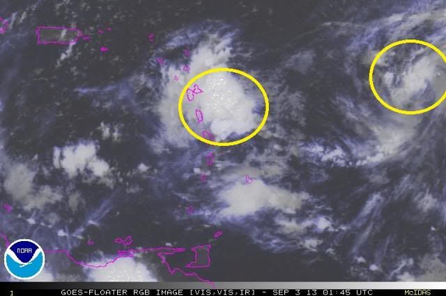
TROPICAL WAVE ESSENTIALLY HAS A DUAL CENTER NOW. ONE OVER GUADELOUPE
AND THE OTHER TOWARDS THE EAST AT 54W. THE EASTERN PART HAS A MUCH
BROADER AREA OF MOISTURE TO DRAW ON...BUT IF THE GFS IS CORRECT THE
TWO WILL LIKELY MERGE SOMEWHERE NORTH OR NORTHWEST OF PR. BELIEVE
THE WAVE CENTER NEAR GUADELOUPE WILL PASS SOUTH AND SOUTHWEST OF
PR BUT REMAIN RATHER DISORGANIZED. THE BIGGER CONCERN REGARDS A
FLOODING THREAT. GFS AND ECMWF AGREE FAIRLY WELL IN THE FIRST WAVE
BEING OVER THE MONA PASSAGE THU MORNING WITH A DEEP SOUTH OR
SOUTHEAST FLOW SETTING UP. GFS SHOWS US IN VICINITY OF A TROPICAL
PLUME FOR AN ENTIRE WEEK AFTERWARD. BUT THE TIMING OF FLOODING
RAINS AND LOCATION OF THIS POTENTIAL MOIST FLOW ARE BOTH A BIG
QUESTION. MODELS ALSO HAVEN/T BEEN CONSISTENT ENOUGH TO HAVE MUCH
CONFIDENCE EITHER.
0 likes   
Visit the Caribbean-Central America Weather Thread where you can find at first post web cams,radars
and observations from Caribbean basin members Click Here

ozonepete
Professional-Met
Professional-Met
Posts: 4743
Joined: Mon Sep 07, 2009 3:23 pm
Location: From Ozone Park, NYC / Now in Brooklyn, NY

Re: ATL: INVEST 97L - Discussion

#494 Postby ozonepete » Mon Sep 02, 2013 10:04 pm

:uarrow: Thanks, Luis. That's exactly what I was getting at in my last post. Whether it's a clearly visible, or clean, merge or not, something looks pretty sure to come out of this over the next few days. And so looks like PR should get a lot of heavy rain imho.
0 likes   

ozonepete
Professional-Met
Professional-Met
Posts: 4743
Joined: Mon Sep 07, 2009 3:23 pm
Location: From Ozone Park, NYC / Now in Brooklyn, NY

Re: ATL: INVEST 97L - Discussion

#495 Postby ozonepete » Mon Sep 02, 2013 10:10 pm

Also, it looks like Martinique north to Guadeloupe, and all of the islands north of there such as Antigua and St. Martin are going to get some really intense rain tonight and tomorrow. It would be prudent for our friends there to get ready for some possibly serious flooding - not sure if it will happen but you need to be ready just in case.
0 likes   

User avatar
Hammy
Category 5
Category 5
Posts: 5849
Age: 41
Joined: Fri May 25, 2012 5:25 pm
Contact:

#496 Postby Hammy » Mon Sep 02, 2013 10:36 pm

0 likes   
The above post is not official and should not be used as such. It is the opinion of the poster and may or may not be backed by sound meteorological data. It is not endorsed by any professional institution or storm2k.org. For official information, please refer to the NHC and NWS products.

floridasun78
Category 5
Category 5
Posts: 3755
Joined: Sun May 17, 2009 10:16 pm
Location: miami fl

Re:

#497 Postby floridasun78 » Mon Sep 02, 2013 10:50 pm

Hammy wrote:seems to finally be consolidating (though I recall saying the same yesterday) but it is certainly looking much better and more concentrated than 24 hours ago.


http://199.9.2.143/tcdat/tc13/ATL/97L.INVEST/ir/geo/1km/20130902.0315.goes13.x.ir1km.97LINVEST.30kts-1008mb-140N-607W.100pc.jpg
http://199.9.2.143/tcdat/tc13/ATL/97L.INVEST/ir/geo/1km/20130903.0315.goes13.x.ir1km.97LINVEST.25kts-1009mb-143N-605W.100pc.jpg

good catch Hammy that interesting
0 likes   

User avatar
MGC
S2K Supporter
S2K Supporter
Posts: 5899
Joined: Sun Mar 23, 2003 9:05 pm
Location: Pass Christian MS, or what is left.

Re: ATL: INVEST 97L - Discussion

#498 Postby MGC » Mon Sep 02, 2013 11:48 pm

Nice blow up of convection over the island this evening.....MGC
0 likes   

User avatar
LaBreeze
Category 5
Category 5
Posts: 1497
Joined: Thu Sep 04, 2003 1:57 pm
Location: SW Louisiana

Re: ATL: INVEST 97L - Discussion

#499 Postby LaBreeze » Tue Sep 03, 2013 12:03 am

After giving the Bahamas some pretty good showers, shouldn't it move north and then northeastward out to sea? Wondering.
0 likes   
Audrey (1957), Carla (1961), Hilda (1964), Betsy (1965), Edith (1971), Carmen (1974), Danny (1985), Juan (1985), Andrew (1992), Lili (2002), Rita (2005), Gustav (2008), Ike (2008), and stuck in the eye of Iniki (1992) while vacationing in Kauai.

Not an official forecast by any means.

User avatar
Fego
S2K Supporter
S2K Supporter
Posts: 767
Age: 65
Joined: Sun Apr 18, 2004 7:58 pm
Location: San Juan, Puerto Rico
Contact:

Re: ATL: INVEST 97L - Discussion

#500 Postby Fego » Tue Sep 03, 2013 1:44 am

Finally, a step forward.
03/0545 UTC 14.8N 61.4W T1.0/1.0 97L -- Atlantic
0 likes   
Go Giants! Go Niners! Go Warriors!


Return to “2013”

Who is online

Users browsing this forum: No registered users and 6 guests