Low level vorticity has been increasing throughout the day...perhaps this is the "Yucatan Effect" in action?
http://tropic.ssec.wisc.edu/real-time/w ... oom=&time=
ATL: INVEST 92L - Discussion
Moderator: S2k Moderators
-
northtxboy

- Category 1

- Posts: 262
- Age: 44
- Joined: Mon Jan 03, 2011 1:50 pm
- Location: Windom Tx
- Contact:
Re: Re:
ozonepete wrote:Ntxw wrote:As wxman57 mentioned this morning two options are still fairly clear. If it heads north it's going to get ripped apart by roaring shear (deep trough over the eastern conus with 50+kts of shear) as it gets near the northern gulf. Staying in the BOC is the best chance of survival and maybe some development (questionable though) before hitting land likely MX.
We need clarification from wxman since I don't know where that post was, but the shear between this disturbance and the Gulf coast is dropping rapidly and will stay low to moderate until this comes ashore if it does go north. There is nothing anywhere near 50 knots of shear there now and nothing like that is expected there over the next few days. The max I see on shear forecast charts is 15 to 20 knots of moderate shear from the southwest but not until it is almost onshore, and each model run shows that dropping.
What effects will less shear have on 92l?? Does less shear mean more trouble?
0 likes
-
TropicalAnalystwx13

- Category 5

- Posts: 2109
- Age: 28
- Joined: Tue Jul 19, 2011 8:20 pm
- Location: Wilmington, NC
- Contact:
-
ozonepete
- Professional-Met

- Posts: 4743
- Joined: Mon Sep 07, 2009 3:23 pm
- Location: From Ozone Park, NYC / Now in Brooklyn, NY
Re:
Ntxw wrote::uarrow:
This was his post this morning.wxman57 wrote:I think 50% is quite generous. Thinking 20-30% at most. Just way too much shear now. Upper low to NW, upper high to SE. Not in a good position to develop. If it tracks north it runs into 50-60kt SW winds off the LA coast in 24-36 hrs. I think part of the moisture goes north, part west. Have to watch the part that goes west more, as it may be the only chance of development.
...having to hold Bones back from the mic now.
I checked the models including short term guidance and indeed he is correct. For the next 36 hours the trough is still digging and there is a wall of winds right along the coast. If it stays down there long enough, you could be right and shear backs off but until then there is plenty of it up there. BOC is much more favorable. If we were talking about a well developed system and created it's own environment, could be a different story but it's currently not.
http://i39.tinypic.com/2iux44p.gif
Thanks for finding the post.
0 likes
-
ozonepete
- Professional-Met
- Posts: 4743
- Joined: Mon Sep 07, 2009 3:23 pm
- Location: From Ozone Park, NYC / Now in Brooklyn, NY
Re: Re:
northtxboy wrote:ozonepete wrote:Ntxw wrote:As wxman57 mentioned this morning two options are still fairly clear. If it heads north it's going to get ripped apart by roaring shear (deep trough over the eastern conus with 50+kts of shear) as it gets near the northern gulf. Staying in the BOC is the best chance of survival and maybe some development (questionable though) before hitting land likely MX.
We need clarification from wxman since I don't know where that post was, but the shear between this disturbance and the Gulf coast is dropping rapidly and will stay low to moderate until this comes ashore if it does go north. There is nothing anywhere near 50 knots of shear there now and nothing like that is expected there over the next few days. The max I see on shear forecast charts is 15 to 20 knots of moderate shear from the southwest but not until it is almost onshore, and each model run shows that dropping.
What effects will less shear have on 92l?? Does less shear mean more trouble?
Yes in that it means more chance for it to intensify before it hits more adverse conditions and / or hits land.
0 likes
-
ozonepete
- Professional-Met
- Posts: 4743
- Joined: Mon Sep 07, 2009 3:23 pm
- Location: From Ozone Park, NYC / Now in Brooklyn, NY
Re:
TropicalAnalystwx13 wrote:There are a few indications a surface low is becoming better defined over the northwestern Yucatan Peninsula. This is where the strongest 925mb vorticity is located as well. If this pans out, I'd expect a poleward track into Louisiana.
Yeah, watch the winds at Merida, Yucatan. They have been NE to NNE with a dropping pressure all day, while winds are SE all day at Cancun. So the LLC is developing between them. If the winds shift to west or southwest at Merida, we will know the center has moved offshore. Here's the link to Merida's station reports:
http://weather.noaa.gov/weather/current/MMMD.html

0 likes
-
hurricanekid416
- Tropical Storm

- Posts: 179
- Joined: Wed Oct 24, 2012 2:43 pm
It seems like 2 circulations are splitting
0 likes
Personal Forecast Disclaimer:
The posts in this forum are NOT official forecast and should not be used as such. They are just the opinion of the poster and may or may not be backed by sound meteorological data. They are NOT endorsed by any professional institution or storm2k.org. For official information, please refer to the NHC and NWS products.
The posts in this forum are NOT official forecast and should not be used as such. They are just the opinion of the poster and may or may not be backed by sound meteorological data. They are NOT endorsed by any professional institution or storm2k.org. For official information, please refer to the NHC and NWS products.
-
cycloneye

- Admin

- Posts: 149719
- Age: 69
- Joined: Thu Oct 10, 2002 10:54 am
- Location: San Juan, Puerto Rico
Re: ATL: INVEST 92L - Discussion
A BROAD LOW PRESSURE SYSTEM...ACCOMPANIED BY A LARGE AREA OF
DISORGANIZED CLOUDINESS AND SHOWERS...IS LOCATED OVER THE CENTRAL
YUCATAN PENINSULA. LITTLE OR NO DEVELOPMENT OF THE LOW IS EXPECTED
WHILE IT REMAINS OVER LAND TONIGHT...BUT THERE IS STILL POTENTIAL
FOR DEVELOPMENT ONCE THE DISTURBANCE MOVES OVER THE GULF OF MEXICO
ON FRIDAY. AFTER THAT TIME...THE LOW IS FORECAST TO MOVE TOWARD THE
CENTRAL GULF OF MEXICO WHERE UPPER-LEVEL WINDS WOULD ONLY FAVOR
SLOW DEVELOPMENT...IF ANY. THIS SYSTEM HAS A MEDIUM CHANCE...50
PERCENT...OF BECOMING A TROPICAL CYCLONE DURING THE NEXT 48
HOURS...AND A HIGH CHANCE...60 PERCENT...OF BECOMING A TROPICAL
CYCLONE DURING THE NEXT 5 DAYS. AN AIR FORCE RESERVE RECONNAISSANCE
AIRCRAFT IS SCHEDULED TO INVESTIGATE THE DISTURBANCE ON FRIDAY...
IF NECESSARY.
0 likes
Visit the Caribbean-Central America Weather Thread where you can find at first post web cams,radars
and observations from Caribbean basin members Click Here
and observations from Caribbean basin members Click Here
-
TropicalAnalystwx13
- Category 5
- Posts: 2109
- Age: 28
- Joined: Tue Jul 19, 2011 8:20 pm
- Location: Wilmington, NC
- Contact:
-
Rgv20

- S2K Supporter

- Posts: 2466
- Age: 39
- Joined: Wed Jan 05, 2011 5:42 pm
- Location: Edinburg/McAllen Tx
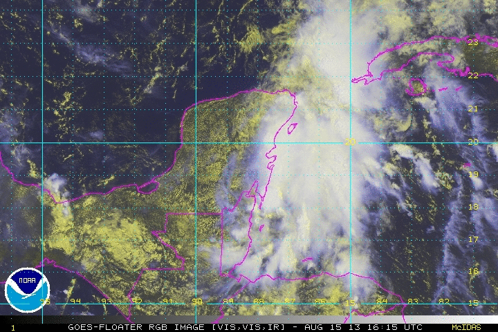
This is the latest Satellite Image of 92L....Hard to pick out an actual Low it just seems like a broad area of Low Pressure for now..

0 likes
The following post is NOT an official forecast and should not be used as such. It is just the opinion of the poster and may or may not be backed by sound meteorological data. It is NOT endorsed by any professional institution including storm2k.org For Official Information please refer to the NHC and NWS products.
-
Hurricaneman

- Category 5
- Posts: 7404
- Age: 45
- Joined: Tue Aug 31, 2004 3:24 pm
- Location: central florida
Re: ATL: INVEST 92L - Discussion
seems to be emerging off the north central coast of the Yucatan, tonight will be the time to see if anything develops
The posts in this forum are NOT official forecast and should not be used as such. They are just the opinion of the poster and may or may not be backed by sound meteorological data. They are NOT endorsed by any professional institution or storm2k.org. For official information, please refer to the NHC and NWS products
The posts in this forum are NOT official forecast and should not be used as such. They are just the opinion of the poster and may or may not be backed by sound meteorological data. They are NOT endorsed by any professional institution or storm2k.org. For official information, please refer to the NHC and NWS products
0 likes
-
bamajammer4eva
- Category 4

- Posts: 907
- Joined: Sun Apr 18, 2010 3:21 am
- Location: Ozark, AL

Re: ATL: INVEST 92L - Discussion
Shear can be a tricky thing. The position of the trough relative to the storm can either ventilate a storm, increasing upper-level divergence and strengthening it, or it can (more likely) rip a storm apart. In this case, it all depends on the position of 92L relative to the shear axis. I don't think the more northern path guarantees that 92L will be destroyed, as it could remain east of the shear, but it does mean that any TC making landfall in the north gulf coast would likely be asymmetric
0 likes
-
ozonepete
- Professional-Met
- Posts: 4743
- Joined: Mon Sep 07, 2009 3:23 pm
- Location: From Ozone Park, NYC / Now in Brooklyn, NY
Re: ATL: INVEST 92L - Discussion
BigA wrote:Shear can be a tricky thing. The position of the trough relative to the storm can either ventilate a storm, increasing upper-level divergence and strengthening it, or it can (more likely) rip a storm apart. In this case, it all depends on the position of 92L relative to the shear axis. I don't think the more northern path guarantees that 92L will be destroyed, as it could remain east of the shear, but it does mean that any TC making landfall in the north gulf coast would likely be asymmetric
Well congratulations! And PhD? That's awesome. As for your comments, you said it very well. The models have consistently stretched out this low if it goes north. I'm just wondering now if the shear really lessens as forecast, which could happen if the trough weakens and lifts north. If so this may not stretch out as much as has been forecast and the game could change. Shear analysis and forecasts are still so primitive. All you can do is watch and wait.
0 likes
-
cycloneye
- Admin
- Posts: 149719
- Age: 69
- Joined: Thu Oct 10, 2002 10:54 am
- Location: San Juan, Puerto Rico
Re: ATL: INVEST 92L - Discussion
00z Best Track. Is the first time since 92L has been up that ATCF adds a low.
AL, 92, 2013081600, , BEST, 0, 198N, 891W, 25, 1009, LO
AL, 92, 2013081600, , BEST, 0, 198N, 891W, 25, 1009, LO
0 likes
Visit the Caribbean-Central America Weather Thread where you can find at first post web cams,radars
and observations from Caribbean basin members Click Here
and observations from Caribbean basin members Click Here
-
wxman57

- Moderator-Pro Met

- Posts: 23175
- Age: 68
- Joined: Sat Jun 21, 2003 8:06 pm
- Location: Houston, TX (southwest)
Re: Re:
ozonepete wrote:
Thanks for finding the post.He just misread the shear - there is nothing like 50-60 knots of shear there now and none expected as I just explained - not off the coast, only inland. Also, the shear chart you attached shows shear less than 20 knots over where the COC is situated now - northern Yucatan - and is even lower everywhere northwestward of there (5 to 10 knots). The higher shear of 20 knots or more is off the eastern coast of the Yucatan and eastward, and the COC is already west of there so that shear is not relevant.
I had said SW winds at 50-60 kts, not shear, as the system moves north toward the coast. The map posted above is current shear, not shear in 48 hrs. Maps below indicate future winds and shear. 50kt winds off the LA coast and 50+ kts shear offshore. 30+ kts shear down to the central Gulf by Saturday. Anything in the central Gulf is toast. There's
200mb wind (not the strongest level):

Current Shear Approaching 50kts North of Yucatan:

Shear Saturday:

0 likes
-
Dean4Storms
- S2K Supporter
- Posts: 6358
- Age: 63
- Joined: Sun Aug 31, 2003 1:01 pm
- Location: Miramar Bch. FL
Re: ATL: INVEST 92L - Discussion
cycloneye wrote:00z Best Track. Is the first time since 92L has been up that ATCF adds a low.
AL, 92, 2013081600, , BEST, 0, 198N, 891W, 25, 1009, LO
Disagree with that position though, NE of there.
0 likes
-
Hurricaneman
- Category 5
- Posts: 7404
- Age: 45
- Joined: Tue Aug 31, 2004 3:24 pm
- Location: central florida
Re: ATL: INVEST 92L - Discussion
Dean4Storms wrote:cycloneye wrote:00z Best Track. Is the first time since 92L has been up that ATCF adds a low.
AL, 92, 2013081600, , BEST, 0, 198N, 891W, 25, 1009, LO
Disagree with that position though, NE of there.
If you look at the satellite pics and the surface observations the low is most certainly not to the northeast but where bast track puts it, what you see to the NE is the MLC
Last edited by Hurricaneman on Thu Aug 15, 2013 7:32 pm, edited 1 time in total.
0 likes
-
TropicalAnalystwx13
- Category 5
- Posts: 2109
- Age: 28
- Joined: Tue Jul 19, 2011 8:20 pm
- Location: Wilmington, NC
- Contact:
-
Dean4Storms
- S2K Supporter
- Posts: 6358
- Age: 63
- Joined: Sun Aug 31, 2003 1:01 pm
- Location: Miramar Bch. FL
Re: ATL: INVEST 92L - Discussion
Hurricaneman wrote:Dean4Storms wrote:cycloneye wrote:00z Best Track. Is the first time since 92L has been up that ATCF adds a low.
AL, 92, 2013081600, , BEST, 0, 198N, 891W, 25, 1009, LO
Disagree with that position though, NE of there.
If you look at the satellite pics and the surface observations the low is most certainly not to the northeast but where bast track puts it, what you see to the NE is the MLC
Merida is reporting 29.79" and falling and Sat. loop shows a circulation to their east. I can't find any pressures lower than that nearby.
0 likes
Who is online
Users browsing this forum: No registered users and 50 guests