Yes, no doubt there is now some obvious cyclonic spin to 92L at the mid levels. So, where will the LL center form if it does? UL conditions are near ideal right now, down the road when it gets into the GOM it might be a different story. That ULL or shear axis is stubborn or so it appears, so expect so increased shear as 92L enters the GOM. I am going with the northern solution. On WWL TV at noon, the model the met ran showed a TC approaching the Louisiana coast, can't remember the name of the model but it was one the station pays for, not the GFS or Euro......MGC
The above is the opinion of MGC and not an official forecast.
ATL: INVEST 92L - Discussion
Moderator: S2k Moderators
-
MGC

- S2K Supporter

- Posts: 5941
- Joined: Sun Mar 23, 2003 9:05 pm
- Location: Pass Christian MS, or what is left.
Re: ATL: INVEST 92L - Discussion
0 likes

Re: ATL: INVEST 92L - Discussion
thats where I have the low as well on that map....easy to see on 1KM view....  NWS in Houston has good idea. Follow the EURO....
if its moving at 15 knts and 180 east of the Yucatan, I was off by 2 hours...10pm..
if its moving at 15 knts and 180 east of the Yucatan, I was off by 2 hours...10pm..
Last edited by ROCK on Wed Aug 14, 2013 4:26 pm, edited 1 time in total.
0 likes

Re: Re:
hurricanekid416 wrote:gatorcane wrote:Here is an image of where NHC has the low. Looks like it is on the western side of the big blob, so that would mean there is some shear impacting this system:
I doubt that's where the llc is if there was a llc which it may not have its where the storm is wrapping up not saying nhc is wrong because they are professionals

NHC has all the tools to tell where an LLC is, now that's not saying one will not form to the northeast with the T-storms but I think they have it right and this system will likely stay weak if the Low level circualtion and mid level circulation don't align which is very possible.
0 likes
The following post is NOT an official forecast and should not be used as such. It is just the opinion of the poster and may or may not be backed by sound meteorological data. It is NOT endorsed by any professional institution including storm2k.org For Official Information please refer to the NHC and NWS products.
-
vbhoutex

- Storm2k Executive

- Posts: 29150
- Age: 74
- Joined: Wed Oct 09, 2002 11:31 pm
- Location: Cypress, TX
- Contact:
Re: ATL: INVEST 92L - Discussion
wxwatcher4405 wrote:Is there a chance this makes it as far west as Tx/La border?
I think the possibilities that have been previously discussed are the most likely. Those are N Gulf Coast from NO East to the FL panhandle or Northern Mexico somewhere S of Brownsville. Personally I am still split on which one to go with, but if the LLC initializes further West than the convection I would pick the Southern route. However, based on modeling right now I think the N Gulf solution is most likely. Intensity is up in the air for me.
0 likes
Skywarn, C.E.R.T.
Please click below to donate to STORM2K to help with the expenses of keeping the site going:

Please click below to donate to STORM2K to help with the expenses of keeping the site going:
Re: ATL: INVEST 92L - Discussion
MGC, sure it wasn't BoB Breck and his damn Vipr model. LoL
0 likes
The following post is NOT an official forecast and should not be used as such. It is just the opinion of the poster and may or may not be backed by sound meteorological data. It is NOT endorsed by any professional institution including storm2k.org For Official Information please refer to the NHC and NWS products.
-
MGC
- S2K Supporter
- Posts: 5941
- Joined: Sun Mar 23, 2003 9:05 pm
- Location: Pass Christian MS, or what is left.
Re: ATL: INVEST 92L - Discussion
Not Bob Breck, it was Ch 4. It will be interesting to see what Bob has to say tonight.....MGC
0 likes
-
deltadog03

- Professional-Met

- Posts: 3580
- Joined: Tue Jul 05, 2005 6:16 pm
- Location: Macon, GA
-
tropicwatch

- Category 5

- Posts: 3427
- Age: 62
- Joined: Sat Jun 02, 2007 10:01 am
- Location: The Villages, Florida
- Contact:
Re: ATL: INVEST 92L - Discussion
This is a starting to be a nice looking system with outflow to the north and northeast. It also appears to be being pulled a little more northward.
0 likes
Tropicwatch
Agnes 72', Eloise 75, Elena 85', Kate 85', Charley 86', Florence 88', Beryl 94', Dean 95', Erin 95', Opal 95', Earl 98', Georges 98', Ivan 2004', Arlene 2005', Dennis 2005', Ida 2009' Debby 2012' Irma 2017' Michael 2018'
Agnes 72', Eloise 75, Elena 85', Kate 85', Charley 86', Florence 88', Beryl 94', Dean 95', Erin 95', Opal 95', Earl 98', Georges 98', Ivan 2004', Arlene 2005', Dennis 2005', Ida 2009' Debby 2012' Irma 2017' Michael 2018'
-
stormhunter7

- Category 2

- Posts: 763
- Joined: Mon May 26, 2008 3:13 pm
- Location: Panama City Beach, Florida
- Contact:
Re: ATL: INVEST 92L - Discussion
Just a note, IMO... The NAVGEM (New Navy Model) has done extremely well with 92L and its current position is pretty close to what system had on sun/mon/tues.
0 likes
The following post is NOT an official forecast and should not be used as such. It is just the opinion of the poster and may or may not be backed by sound meteorological data. It is NOT endorsed by any professional institution including storm2k.org For Official Information please refer to the NHC and NWS products. http://www.nhc.noaa.gov
-
CaneCurious

- Tropical Storm

- Posts: 160
- Joined: Wed Aug 25, 2004 1:40 pm
- Location: Kenner, LA
Re: ATL: INVEST 92L - Discussion
MGC wrote:Not Bob Breck, it was Ch 4. It will be interesting to see what Bob has to say tonight.....MGC
It was Derek Kevra on WWL and it was the Precisioncast Model. He posted on his Facebook page that the model changed its tune this afternoon and shows more of a sheared system affecting us here in SELA.
0 likes
-
Frank P
- S2K Supporter
- Posts: 2779
- Joined: Fri Aug 29, 2003 10:52 am
- Location: Biloxi Beach, Ms
- Contact:
Re: ATL: INVEST 92L - Discussion
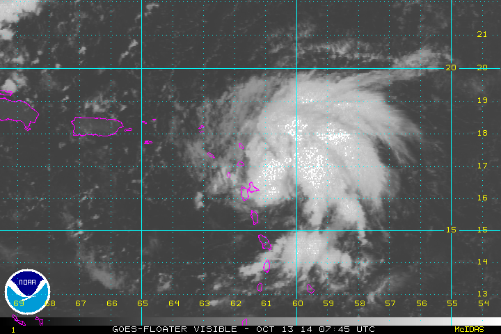
Gee, if it continues that path as shown in the vis sat loop above it might just clip the NE section of the Yucatan Pens... and not spend very much time over land...
0 likes
-
CrazyC83
- Professional-Met
- Posts: 34316
- Joined: Tue Mar 07, 2006 11:57 pm
- Location: Deep South, for the first time!
Re: ATL: INVEST 92L - Discussion
Frank P wrote:Gee, if it continues that path as shown in the vis sat loop above it might just clip the NE section of the Yucatan Pens... and not spend very much time over land...
That would probably send it racing northeast with the trough as well...so many possibilities.
0 likes
-
Dean4Storms
- S2K Supporter
- Posts: 6358
- Age: 63
- Joined: Sun Aug 31, 2003 1:01 pm
- Location: Miramar Bch. FL

Re: ATL: INVEST 92L - Discussion
My question is what is the likely hood of 92L to miss the trough that is dipping down into the Northern GoM and end up staying in the GoM meandering around for a few days until there is something there to actually direct it to go either West, North, or North East?
Right now my thinking is that if it develops a little faster and a little more to the East than what the NHC is depicting right now, I have a feeling final landfall will be somewhere in between Sabine Pass and Tallahassee. Now if it decides to stay a week wave and doesn't form, it could possibly die over the flats of the Yucatan Peninsula.
Right now my thinking is that if it develops a little faster and a little more to the East than what the NHC is depicting right now, I have a feeling final landfall will be somewhere in between Sabine Pass and Tallahassee. Now if it decides to stay a week wave and doesn't form, it could possibly die over the flats of the Yucatan Peninsula.
0 likes
Personal Forecast Disclaimer:
The posts in this forum are NOT official forecast and should not be used as such. They are just the opinion of the poster and may or may not be backed by sound meteorological data. They are NOT endorsed by any professional institution or storm2k.org. For official information, please refer to the NHC and NWS products.
The posts in this forum are NOT official forecast and should not be used as such. They are just the opinion of the poster and may or may not be backed by sound meteorological data. They are NOT endorsed by any professional institution or storm2k.org. For official information, please refer to the NHC and NWS products.
-
wxwatcher4405
- Tropical Wave

- Posts: 7
- Joined: Tue Jul 09, 2013 9:52 am
Re: ATL: INVEST 92L - Discussion
Blinhart wrote:My question is what is the likely hood of 92L to miss the trough that is dipping down into the Northern GoM and end up staying in the GoM meandering around for a few days until there is something there to actually direct it to go either West, North, or North East?
Right now my thinking is that if it develops a little faster and a little more to the East than what the NHC is depicting right now, I have a feeling final landfall will be somewhere in between Sabine Pass and Tallahassee. Now if it decides to stay a week wave and doesn't form, it could possibly die over the flats of the Yucatan Peninsula.
Wow...Sabine Pass...do you really think it can go that far west?
0 likes
Re: ATL: INVEST 92L - Discussion
wxwatcher4405 wrote:Blinhart wrote:My question is what is the likely hood of 92L to miss the trough that is dipping down into the Northern GoM and end up staying in the GoM meandering around for a few days until there is something there to actually direct it to go either West, North, or North East?
Right now my thinking is that if it develops a little faster and a little more to the East than what the NHC is depicting right now, I have a feeling final landfall will be somewhere in between Sabine Pass and Tallahassee. Now if it decides to stay a week wave and doesn't form, it could possibly die over the flats of the Yucatan Peninsula.
Wow...Sabine Pass...do you really think it can go that far west?
The difference between Sabine Pass and New Orleans is only a couple hundred miles, so yeah I think that is the furthest West it would be able to make it if it takes the Northern Path, normally I usually would of said Vermillion Bay, but my gut is telling me to look at the Sabine Pass area.
0 likes
Personal Forecast Disclaimer:
The posts in this forum are NOT official forecast and should not be used as such. They are just the opinion of the poster and may or may not be backed by sound meteorological data. They are NOT endorsed by any professional institution or storm2k.org. For official information, please refer to the NHC and NWS products.
The posts in this forum are NOT official forecast and should not be used as such. They are just the opinion of the poster and may or may not be backed by sound meteorological data. They are NOT endorsed by any professional institution or storm2k.org. For official information, please refer to the NHC and NWS products.
Re: ATL: INVEST 92L - Discussion
I am almost 99% sure Sabine Pass is a tad west of guidance or east depending on what camp you are in....
0 likes
-
wxman57

- Moderator-Pro Met

- Posts: 23175
- Age: 68
- Joined: Sat Jun 21, 2003 8:06 pm
- Location: Houston, TX (southwest)
Re: ATL: INVEST 92L - Discussion
Blinhart wrote:
The difference between Sabine Pass and New Orleans is only a couple hundred miles, so yeah I think that is the furthest West it would be able to make it if it takes the Northern Path, normally I usually would of said Vermillion Bay, but my gut is telling me to look at the Sabine Pass area.
But that's a big difference with respect to the predicted mid to upper-level wind flow. East of Vermilion Bay, winds are out of the southwest aloft. West of there, NW winds aloft. Hard for a storm to track against the upper level winds and get to Sabine Pass.
0 likes
-
deltadog03
- Professional-Met
- Posts: 3580
- Joined: Tue Jul 05, 2005 6:16 pm
- Location: Macon, GA
-
Rgv20

- S2K Supporter
- Posts: 2466
- Age: 39
- Joined: Wed Jan 05, 2011 5:42 pm
- Location: Edinburg/McAllen Tx
Afternoon Discussion out of the NWS in San Antonio..
SOUTH CENTRAL TEXAS WILL REMAIN RAIN
FREE SUNDAY THRU WEDNESDAY WITH ONE CAVEAT. THERE IS AN AREA OF
LOW PRESSURE WEST OF THE YUCATAN MOVING WESTWARD. THIS FEATURE MAY
BECOME A TROPICAL DEPRESSION AND THEN MOVE INTO THE BAY OF
CAMPECHE ON FRIDAY. SOME NUMERICAL MODELS FORECAST A SFC
CIRCULATION FORMING BY SATURDAY OVER THE SW GULF. THE MOVEMENT OF
THIS FEATURE MAY HAVE AN IMPACT ON OUR RAIN-FREE FORECAST FOR
NEXT WEEK. TEMPERATURES FRIDAY THROUGH WEDNESDAY WILL SEE A SLIGHT
DOWNWARD TREND TOWARDS SEASONAL NORMALS DUE TO THE ABSENCE OF THE
UPPER LEVEL RIDGE.
0 likes
The following post is NOT an official forecast and should not be used as such. It is just the opinion of the poster and may or may not be backed by sound meteorological data. It is NOT endorsed by any professional institution including storm2k.org For Official Information please refer to the NHC and NWS products.
Who is online
Users browsing this forum: No registered users and 41 guests