ATL: INVEST 92L - Discussion

Moderator: S2k Moderators

Message
Author
SunnyThoughts
Category 5
Category 5
Posts: 2263
Joined: Wed Jul 09, 2003 12:42 pm
Location: Pensacola, Florida

Re: ATL: INVEST 92L - Discussion

#281 Postby SunnyThoughts » Wed Aug 14, 2013 1:31 pm

DestinTiger wrote:I just found this forum, and appreciate all the knowledge here. I'm in Destin, FL and this storm reminds me so much of Opal. Am I just being paranoid?

Sent from my HTC One using Tapatalk 2


Hi Destin, Pensacola here ( actually Pace, but nobody would know where that is lol) welcome to the forum. Great meteorologists and information here.
0 likes   

tolakram
Admin
Admin
Posts: 20009
Age: 62
Joined: Sun Aug 27, 2006 8:23 pm
Location: Florence, KY (name is Mark)

Re: ATL: INVEST 92L - Discussion

#282 Postby tolakram » Wed Aug 14, 2013 1:31 pm

0 likes   
M a r k
- - - - -
Join us in chat: Storm2K Chatroom Invite. Android and IOS apps also available.

The posts in this forum are NOT official forecasts and should not be used as such. Posts are NOT endorsed by any professional institution or STORM2K.org. For official information and forecasts, please refer to NHC and NWS products.

MiamiensisWx

Re: ATL: INVEST 92L - Discussion

#283 Postby MiamiensisWx » Wed Aug 14, 2013 1:35 pm

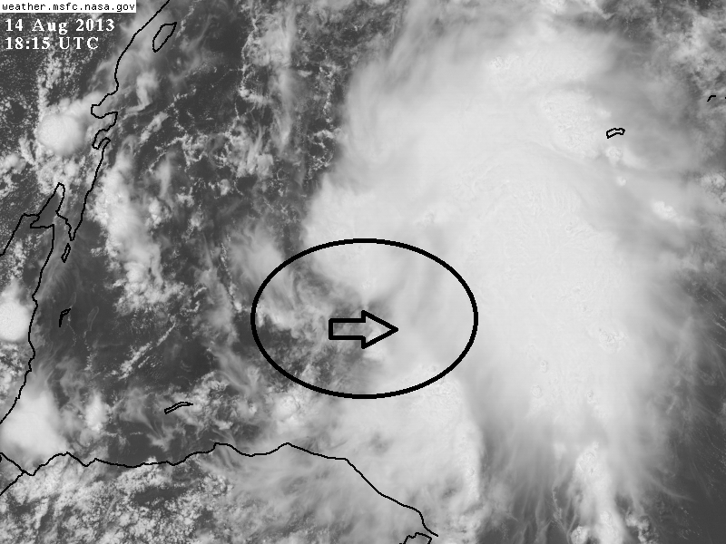
I definitely see a low-level vortex near 17.8°N 83.9°W on the latest visible satellite imagery, which is a bit SW of the mid-level circulation. I think that as convection continues to increase, the banding-type formation (a key precursor to TC genesis; note the comma shape on latest imagery) will tend to form a new LLC farther to the NE, under the MLC. Once that happens, there may be a quick jump to TS intensity that skips over the TD stage; we saw that with Arthur 2008 and other systems which formed in this area. Based upon the latest T-number estimates and the organization evident on satellite, I think we will see TS Erin within the next 12 hours.

http://www.ssd.noaa.gov/PS/TROP/floaters/92L/flash-rgb-long.html
0 likes   

Alyono
Professional-Met
Professional-Met
Posts: 6961
Joined: Fri Apr 26, 2013 3:52 pm
Location: Texas Coast

Re: ATL: INVEST 92L - Discussion

#284 Postby Alyono » Wed Aug 14, 2013 1:35 pm

Ivanhater wrote:

Wouldn't that be something if this Erin headed toward the Pensacola area. Anyone living in Pensacola in 1995 remembers that Erin quite well before his big sister Opal came a few weeks later.


HIS big sister? LOL
0 likes   

User avatar
tailgater
S2K Supporter
S2K Supporter
Posts: 3339
Joined: Sun Jul 11, 2004 9:13 pm
Location: St. Amant La.

Re:

#285 Postby tailgater » Wed Aug 14, 2013 1:38 pm

Gustywind wrote:Latest from SSD... increasing numbers for 92L.


DATE/TIME LAT LON CLASSIFICATION STORM

14/1745 UTC 17.7N 84.8W T1.0/1.0 92L
14/1145 UTC 17.6N 82.6W TOO WEAK 92L


That would put it @ 225 miles from the Yucatan coast, so I guessing it wouldn't make Landfall till tomorrow morningish.
0 likes   
The following post is NOT an official forecast and should not be used as such. It is just the opinion of the poster and may or may not be backed by sound meteorological data. It is NOT endorsed by any professional institution including storm2k.org For Official Information please refer to the NHC and NWS products.

DestinTiger
Tropical Wave
Tropical Wave
Posts: 3
Joined: Sun Aug 26, 2012 10:32 pm

Re: ATL: INVEST 92L - Discussion

#286 Postby DestinTiger » Wed Aug 14, 2013 1:39 pm

SunnyThoughts wrote:
DestinTiger wrote:I just found this forum, and appreciate all the knowledge here. I'm in Destin, FL and this storm reminds me so much of Opal. Am I just being paranoid?

Sent from my HTC One using Tapatalk 2


Hi Destin, Pensacola here ( actually Pace, but nobody would know where that is lol) welcome to the forum. Great meteorologists and information here.


Thanks for the warm welcomes. Looking forward to soaking up all the information here. Hopefully avoiding getting soaked by this storm at the same time!

Sent from my HTC One using Tapatalk 2
0 likes   

RL3AO
Moderator-Pro Met
Moderator-Pro Met
Posts: 16308
Joined: Thu Jun 14, 2007 10:03 pm
Location: NC

#287 Postby RL3AO » Wed Aug 14, 2013 1:39 pm

Image

I can't tell if I'm seeing westerly winds in the lower levels or not on a loop. If I stare at it any longer, I can probably make myself see anything.
0 likes   

User avatar
MiamiHurricanes10
S2K Supporter
S2K Supporter
Posts: 260
Joined: Mon Jul 19, 2010 7:56 pm
Location: Miami, Florida

Re: ATL: INVEST 92L - Discussion

#288 Postby MiamiHurricanes10 » Wed Aug 14, 2013 1:40 pm


How do you link the loops on GHCC?
0 likes   

User avatar
Ivanhater
Storm2k Moderator
Storm2k Moderator
Posts: 11161
Age: 38
Joined: Fri Jul 01, 2005 8:25 am
Location: Pensacola

Re: ATL: INVEST 92L - Discussion

#289 Postby Ivanhater » Wed Aug 14, 2013 1:40 pm

Alyono wrote:
Ivanhater wrote:

Wouldn't that be something if this Erin headed toward the Pensacola area. Anyone living in Pensacola in 1995 remembers that Erin quite well before his big sister Opal came a few weeks later.


HIS big sister? LOL


Gender confusion...sorry Erin! :lol:
0 likes   
Michael

CYCLONE MIKE
Category 5
Category 5
Posts: 2183
Joined: Tue Aug 31, 2004 6:04 pm
Location: Gonzales, LA

Re: ATL: INVEST 92L - Discussion

#290 Postby CYCLONE MIKE » Wed Aug 14, 2013 1:42 pm

Must say I am impressed by how well this looks in appearance on satellite this afternoon. But as we have have seen a few times so far this season, looks aren't everything. :lol:
0 likes   

User avatar
TeamPlayersBlue
Category 5
Category 5
Posts: 3445
Joined: Tue Feb 02, 2010 1:44 am
Location: Denver/Applewood, CO

#291 Postby TeamPlayersBlue » Wed Aug 14, 2013 1:42 pm

This system is really getting its act together quickly. Goodness. If this convection continues, it will help the system organize quicker. Hopefully it wont be much when it crosses the Yucatan though
0 likes   
Personal Forecast Disclaimer:
The posts in this forum are NOT official forecast and should not be used as such. They are just the opinion of the poster and may or may not be backed by sound meteorological data. They are NOT endorsed by any professional institution or storm2k.org. For official information, please refer to the NHC and NWS products.

User avatar
cycloneye
Admin
Admin
Posts: 145303
Age: 68
Joined: Thu Oct 10, 2002 10:54 am
Location: San Juan, Puerto Rico

Re: ATL: INVEST 92L - Discussion

#292 Postby cycloneye » Wed Aug 14, 2013 1:44 pm

Image
0 likes   
Visit the Caribbean-Central America Weather Thread where you can find at first post web cams,radars
and observations from Caribbean basin members Click Here

tolakram
Admin
Admin
Posts: 20009
Age: 62
Joined: Sun Aug 27, 2006 8:23 pm
Location: Florence, KY (name is Mark)

Re: ATL: INVEST 92L - Discussion

#293 Postby tolakram » Wed Aug 14, 2013 1:44 pm

MiamiHurricanes10 wrote:

How do you link the loops on GHCC?


These are the build your own loops.

Main page: http://weather.msfc.nasa.gov/GOES/getsatellite.html

Here are the URLs for the loops I provided:

Code: Select all

Zoom 1:  http://wwwghcc.msfc.nasa.gov/cgi-bin/get-goes?satellite=GOES-E%20CONUS&lat=15&lon=-83&info=vis&zoom=1&width=1000&height=800&quality=95&type=Animation&palette=ir1.pal&numframes=15

Zoom 2: http://wwwghcc.msfc.nasa.gov/cgi-bin/get-goes?satellite=GOES-E%20CONUS&lat=15&lon=-83&info=vis&zoom=2&width=1000&height=800&quality=95&type=Animation&palette=ir1.pal&numframes=15


You can change zoom level, lat and lon, etc.
0 likes   
M a r k
- - - - -
Join us in chat: Storm2K Chatroom Invite. Android and IOS apps also available.

The posts in this forum are NOT official forecasts and should not be used as such. Posts are NOT endorsed by any professional institution or STORM2K.org. For official information and forecasts, please refer to NHC and NWS products.

User avatar
Rgv20
S2K Supporter
S2K Supporter
Posts: 2466
Age: 38
Joined: Wed Jan 05, 2011 5:42 pm
Location: Edinburg/McAllen Tx

#294 Postby Rgv20 » Wed Aug 14, 2013 1:45 pm

Honestly if I was in the NHC staff I would hate to designate as a TD later today just because of the really tough forecast! lol Shortest discussion ever... "Its going to Rain in the Yucatan Peninsula...End of discussion" lol
0 likes   
The following post is NOT an official forecast and should not be used as such. It is just the opinion of the poster and may or may not be backed by sound meteorological data. It is NOT endorsed by any professional institution including storm2k.org For Official Information please refer to the NHC and NWS products.

User avatar
NDG
S2K Supporter
S2K Supporter
Posts: 15446
Joined: Sun Jul 09, 2006 10:14 pm
Location: Orlando, FL

#295 Postby NDG » Wed Aug 14, 2013 1:48 pm

Nice inflow setting up.

Conditions at 42057 as of
(12:50 pm EST)
1750 GMT on 08/14/2013:

Wind Direction (WDIR): SE ( 130 deg true )
Wind Speed (WSPD): 23.3 kts
Wind Gust (GST): 27.2 kts
Wave Height (WVHT): 7.2 ft
Dominant Wave Period (DPD): 7 sec
Average Period (APD): 5.1 sec
Mean Wave Direction (MWD): E ( 100 deg true )
Atmospheric Pressure (PRES): 29.87 in
Air Temperature (ATMP): 79.2 °F
Water Temperature (WTMP): 82.4 °F
Dew Point (DEWP): 75.9 °F
Heat Index (HEAT): 83.3 °F
Wind Speed at 10 meters (WSPD10M): 25.3 kts
Wind Speed at 20 meters (WSPD20M): 25.3 kts

http://www.ndbc.noaa.gov/station_page.php?station=42057
0 likes   

Airboy
Category 1
Category 1
Posts: 439
Joined: Wed Jul 27, 2011 10:41 am

Re: ATL: INVEST 92L - Discussion

#296 Postby Airboy » Wed Aug 14, 2013 1:48 pm

This could get a bit nasty if it goes north, looks like it will be a big circulation when it gets going.
0 likes   
Personal Forecast Disclaimer:
The posts in this forum are NOT official forecast and should not be used as such. They are just the opinion of the poster and may or may not be backed by sound meteorological data. They are NOT endorsed by any professional institution or storm2k.org. For official information, please refer to the NHC and NWS products.

User avatar
MiamiHurricanes10
S2K Supporter
S2K Supporter
Posts: 260
Joined: Mon Jul 19, 2010 7:56 pm
Location: Miami, Florida

Re: ATL: INVEST 92L - Discussion

#297 Postby MiamiHurricanes10 » Wed Aug 14, 2013 1:49 pm

tolakram wrote:These are the build your own loops.

Main page: http://weather.msfc.nasa.gov/GOES/getsatellite.html

Here are the URLs for the loops I provided:

Code: Select all

Zoom 1:  http://wwwghcc.msfc.nasa.gov/cgi-bin/get-goes?satellite=GOES-E%20CONUS&lat=15&lon=-83&info=vis&zoom=1&width=1000&height=800&quality=95&type=Animation&palette=ir1.pal&numframes=15

Zoom 2: http://wwwghcc.msfc.nasa.gov/cgi-bin/get-goes?satellite=GOES-E%20CONUS&lat=15&lon=-83&info=vis&zoom=2&width=1000&height=800&quality=95&type=Animation&palette=ir1.pal&numframes=15


You can change zoom level, lat and lon, etc.
Perfecttt. Thanks a ton.
0 likes   

User avatar
StormTracker
S2K Supporter
S2K Supporter
Posts: 2903
Age: 59
Joined: Thu Jun 29, 2006 6:06 am
Location: Quail Heights(Redlands), FL.

Re: ATL: INVEST 92L - Discussion

#298 Postby StormTracker » Wed Aug 14, 2013 1:49 pm

CYCLONE MIKE wrote:Must say I am impressed by how well this looks in appearance on satellite this afternoon. But as we have have seen a few times so far this season, looks aren't everything. :lol:

Well we are now in mid-August! Things are a little different now!
0 likes   
Something's wrong when you regret, things that haven't happened yet!

User avatar
KatDaddy
Category 5
Category 5
Posts: 2815
Joined: Mon Oct 21, 2002 6:23 pm
Location: League City, Texas

#299 Postby KatDaddy » Wed Aug 14, 2013 1:50 pm

Invest 92L now up to 60% and code red. From the 2:00PM Tropical Weather Outlook:

THE BROAD AREA OF LOW PRESSURE IN THE NORTHWESTERN CARIBBEAN SEA IS
MOVING TOWARD THE WEST-NORTHWEST AT 10 TO 15 MPH. CLOUDINESS AND
SHOWERS ASSOCIATED WITH THIS LOW CONTINUE TO SHOW SIGNS OF
ORGANIZATION...AND A TROPICAL DEPRESSION COULD FORM BEFORE THE
DISTURBANCE REACHES THE YUCATAN PENINSULA ON THURSDAY. AFTER
THAT...THIS WEATHER SYSTEM IS FORECAST TO MOVE OVER THE GULF OF
MEXICO...WHERE UPPER-LEVEL WINDS WILL LIKELY BE A LITTLE LESS
FAVORABLE FOR DEVELOPMENT. THIS SYSTEM HAS A HIGH CHANCE...60
PERCENT...OF BECOMING A TROPICAL CYCLONE DURING THE NEXT 48
HOURS...AND A HIGH CHANCE...70 PERCENT...OF BECOMING A TROPICAL
CYCLONE DURING THE NEXT 5 DAYS. REGARDLESS OF WHETHER OR NOT A
TROPICAL CYCLONE FORMS...HEAVY RAINS AND GUSTY WINDS ARE FORECAST
TO SPREAD OVER THE YUCATAN PENINSULA AND BELIZE DURING THE NEXT DAY
OR TWO...AND INTERESTS IN THESE AREAS SHOULD MONITOR THE PROGRESS
OF THIS DISTURBANCE.
0 likes   
The following post is NOT an official forecast and should not be used as such. It is just the opinion of the poster and may or may not be backed by sound meteorological data. It is NOT endorsed by any professional institution including storm2k.org For Official Information please refer to the NHC and NWS products.

User avatar
Ivanhater
Storm2k Moderator
Storm2k Moderator
Posts: 11161
Age: 38
Joined: Fri Jul 01, 2005 8:25 am
Location: Pensacola

Re: ATL: INVEST 92L - Discussion

#300 Postby Ivanhater » Wed Aug 14, 2013 1:51 pm

Image
0 likes   
Michael


Return to “2013”

Who is online

Users browsing this forum: No registered users and 9 guests