WPAC: UTOR - Post-Tropical

Moderator: S2k Moderators

Message
Author
Meow

Re: WPAC: UTOR - Typhoon (Labuyo PAGASA)

#141 Postby Meow » Sat Aug 10, 2013 3:44 am

dexterlabio wrote:My bad, was going to type 3.5. :lol: Still no update from the JTWC. It'd be a huge difference if JTWC keeps it at around 60-65kts given that DT number, while JMA is at 70kts, plus the fact that JMA uses 10-min average. :lol:

Finally, JTWC gave 70kt, but this is actually weaker than JMA’s 70kt.

Image

WTPN31 PGTW 100900
SUBJ/TROPICAL CYCLONE WARNING//
1. TYPHOON 11W (UTOR) WARNING NR 007
UPGRADED FROM TROPICAL STORM 11W
01 ACTIVE TROPICAL CYCLONE IN NORTHWESTPAC
MAX SUSTAINED WINDS BASED ON ONE-MINUTE AVERAGE
WIND RADII VALID OVER OPEN WATER ONLY
---
WARNING POSITION:
100600Z --- NEAR 13.8N 129.2E
MOVEMENT PAST SIX HOURS - 280 DEGREES AT 13 KTS
POSITION ACCURATE TO WITHIN 020 NM
POSITION BASED ON CENTER LOCATED BY SATELLITE
PRESENT WIND DISTRIBUTION:
MAX SUSTAINED WINDS - 070 KT, GUSTS 085 KT
WIND RADII VALID OVER OPEN WATER ONLY
RADIUS OF 064 KT WINDS - 025 NM NORTHEAST QUADRANT
020 NM SOUTHEAST QUADRANT
020 NM SOUTHWEST QUADRANT
025 NM NORTHWEST QUADRANT
RADIUS OF 050 KT WINDS - 035 NM NORTHEAST QUADRANT
030 NM SOUTHEAST QUADRANT
030 NM SOUTHWEST QUADRANT
035 NM NORTHWEST QUADRANT
RADIUS OF 034 KT WINDS - 075 NM NORTHEAST QUADRANT
065 NM SOUTHEAST QUADRANT
065 NM SOUTHWEST QUADRANT
070 NM NORTHWEST QUADRANT
REPEAT POSIT: 13.8N 129.2E
---
FORECASTS:
12 HRS, VALID AT:
101800Z --- 14.4N 127.0E
MAX SUSTAINED WINDS - 090 KT, GUSTS 110 KT
WIND RADII VALID OVER OPEN WATER ONLY
RADIUS OF 064 KT WINDS - 035 NM NORTHEAST QUADRANT
030 NM SOUTHEAST QUADRANT
030 NM SOUTHWEST QUADRANT
035 NM NORTHWEST QUADRANT
RADIUS OF 050 KT WINDS - 050 NM NORTHEAST QUADRANT
045 NM SOUTHEAST QUADRANT
045 NM SOUTHWEST QUADRANT
050 NM NORTHWEST QUADRANT
RADIUS OF 034 KT WINDS - 095 NM NORTHEAST QUADRANT
085 NM SOUTHEAST QUADRANT
085 NM SOUTHWEST QUADRANT
095 NM NORTHWEST QUADRANT
VECTOR TO 24 HR POSIT: 290 DEG/ 11 KTS
---
24 HRS, VALID AT:
110600Z --- 15.1N 124.8E
MAX SUSTAINED WINDS - 100 KT, GUSTS 125 KT
WIND RADII VALID OVER OPEN WATER ONLY
RADIUS OF 064 KT WINDS - 035 NM NORTHEAST QUADRANT
035 NM SOUTHEAST QUADRANT
035 NM SOUTHWEST QUADRANT
040 NM NORTHWEST QUADRANT
RADIUS OF 050 KT WINDS - 055 NM NORTHEAST QUADRANT
055 NM SOUTHEAST QUADRANT
055 NM SOUTHWEST QUADRANT
055 NM NORTHWEST QUADRANT
RADIUS OF 034 KT WINDS - 105 NM NORTHEAST QUADRANT
100 NM SOUTHEAST QUADRANT
100 NM SOUTHWEST QUADRANT
105 NM NORTHWEST QUADRANT
VECTOR TO 36 HR POSIT: 290 DEG/ 12 KTS
---
36 HRS, VALID AT:
111800Z --- 16.0N 122.4E
MAX SUSTAINED WINDS - 105 KT, GUSTS 130 KT
WIND RADII VALID OVER OPEN WATER ONLY
RADIUS OF 064 KT WINDS - 040 NM NORTHEAST QUADRANT
035 NM SOUTHEAST QUADRANT
035 NM SOUTHWEST QUADRANT
040 NM NORTHWEST QUADRANT
RADIUS OF 050 KT WINDS - 060 NM NORTHEAST QUADRANT
060 NM SOUTHEAST QUADRANT
060 NM SOUTHWEST QUADRANT
060 NM NORTHWEST QUADRANT
RADIUS OF 034 KT WINDS - 115 NM NORTHEAST QUADRANT
105 NM SOUTHEAST QUADRANT
110 NM SOUTHWEST QUADRANT
115 NM NORTHWEST QUADRANT
VECTOR TO 48 HR POSIT: 295 DEG/ 12 KTS
---
EXTENDED OUTLOOK:
48 HRS, VALID AT:
120600Z --- 16.9N 120.1E
MAX SUSTAINED WINDS - 080 KT, GUSTS 100 KT
WIND RADII VALID OVER OPEN WATER ONLY
RADIUS OF 064 KT WINDS - 030 NM NORTHEAST QUADRANT
025 NM SOUTHEAST QUADRANT
030 NM SOUTHWEST QUADRANT
030 NM NORTHWEST QUADRANT
RADIUS OF 050 KT WINDS - 050 NM NORTHEAST QUADRANT
045 NM SOUTHEAST QUADRANT
050 NM SOUTHWEST QUADRANT
050 NM NORTHWEST QUADRANT
RADIUS OF 034 KT WINDS - 110 NM NORTHEAST QUADRANT
100 NM SOUTHEAST QUADRANT
105 NM SOUTHWEST QUADRANT
110 NM NORTHWEST QUADRANT
VECTOR TO 72 HR POSIT: 295 DEG/ 12 KTS
---
72 HRS, VALID AT:
130600Z --- 18.9N 115.4E
MAX SUSTAINED WINDS - 085 KT, GUSTS 105 KT
WIND RADII VALID OVER OPEN WATER ONLY
RADIUS OF 064 KT WINDS - 035 NM NORTHEAST QUADRANT
030 NM SOUTHEAST QUADRANT
030 NM SOUTHWEST QUADRANT
035 NM NORTHWEST QUADRANT
RADIUS OF 050 KT WINDS - 055 NM NORTHEAST QUADRANT
055 NM SOUTHEAST QUADRANT
055 NM SOUTHWEST QUADRANT
055 NM NORTHWEST QUADRANT
RADIUS OF 034 KT WINDS - 110 NM NORTHEAST QUADRANT
105 NM SOUTHEAST QUADRANT
105 NM SOUTHWEST QUADRANT
110 NM NORTHWEST QUADRANT
VECTOR TO 96 HR POSIT: 300 DEG/ 12 KTS
---
LONG RANGE OUTLOOK:
---
96 HRS, VALID AT:
140600Z --- 21.3N 110.9E
MAX SUSTAINED WINDS - 075 KT, GUSTS 090 KT
WIND RADII VALID OVER OPEN WATER ONLY
VECTOR TO 120 HR POSIT: 310 DEG/ 11 KTS
---
120 HRS, VALID AT:
150600Z --- 23.9N 107.3E
MAX SUSTAINED WINDS - 025 KT, GUSTS 035 KT
WIND RADII VALID OVER OPEN WATER ONLY
DISSIPATING AS A SIGNIFICANT TROPICAL CYCLONE OVER LAND
---
REMARKS:
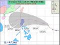
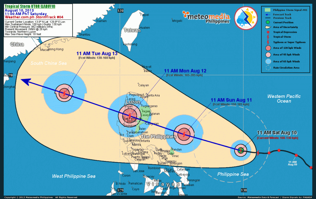
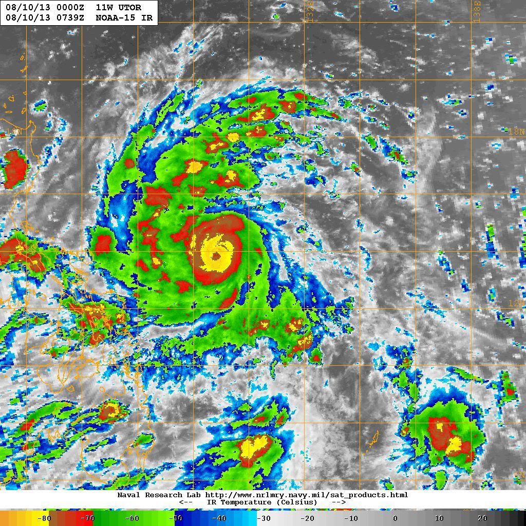
100900Z POSITION NEAR 13.9N 128.7E.
TYPHOON 11W (UTOR), LOCATED APPROXIMATELY 479 NM EASTWARD OF
MANILA, PHILIPPINES, HAS TRACKED WESTWARD AT 13 KNOTS OVER THE
PAST SIX HOURS. MAXIMUM SIGNIFICANT WAVE HEIGHT AT 100600Z IS
22 FEET. NEXT WARNINGS AT 101500Z, 102100Z, 110300Z AND 110900Z.//
BT
#0001
NNNN
0 likes   

User avatar
Filipinas50
Tropical Depression
Tropical Depression
Posts: 77
Age: 60
Joined: Tue May 28, 2013 2:07 am
Location: Planet Earth

Re: WPAC: UTOR - Typhoon (Labuyo PAGASA)

#142 Postby Filipinas50 » Sat Aug 10, 2013 4:00 am

Outer Rainbands of Typhoon Utor are Starting to Show on Virac, Catanduanes Doppler Radar ...

Image

Typhoon Utor Forecast Track as of 1100 Hours 10 August ...

Image
Last edited by Filipinas50 on Sat Aug 10, 2013 6:46 am, edited 1 time in total.
0 likes   
RETIRED FROM THE 9-5 RAT RACE

Typhoon Hunter
WesternPacificWeather.com
Posts: 1221
Joined: Wed Oct 11, 2006 11:37 am
Location: Tokyo
Contact:

Re: WPAC: UTOR - Typhoon (Labuyo PAGASA)

#143 Postby Typhoon Hunter » Sat Aug 10, 2013 4:21 am

Utor cranking impressively! Due to uncertainty in track and possibility of this hitting the most intercept unfriendly part of Philippines (no roads within 40km of the coast) I'm not going to try intercept this in Luzon. Plus with models showing uncertainty once it enters SCS I want to make sure I'm in Hong Kong if it looks like heading this way. Lots of uncertainty ahead!
0 likes   
James - Documenting tropical cyclones...

http://www.youtube.com/TyphoonHunter

Meow

Re: WPAC: UTOR - Typhoon (Labuyo PAGASA)

#144 Postby Meow » Sat Aug 10, 2013 4:28 am

Typhoon Hunter wrote:Utor cranking impressively! Due to uncertainty in track and possibility of this hitting the most intercept unfriendly part of Philippines (no roads within 40km of the coast) I'm not going to try intercept this in Luzon. Plus with models showing uncertainty once it enters SCS I want to make sure I'm in Hong Kong if it looks like heading this way. Lots of uncertainty ahead!


That suits what JMA forecasts.

Image
0 likes   

dexterlabio
Category 5
Category 5
Posts: 3468
Joined: Sat Oct 24, 2009 11:50 pm

Re: WPAC: UTOR - Typhoon (Labuyo PAGASA)

#145 Postby dexterlabio » Sat Aug 10, 2013 4:44 am

I wonder what PAGASA has in mind, because they keep Utor at 105 km/hr (roughly 60kts)...they're basically left out.. and PAGASA uses 10-min average, same with JMA.
0 likes   
Personal Forecast Disclaimer:
The posts in this forum are NOT official forecast and should not be used as such. They are just the opinion of the poster and may or may not be backed by sound meteorological data. They are NOT endorsed by any professional institution or storm2k.org. For official information, please refer to the NHC and NWS products.

User avatar
xtyphooncyclonex
Category 5
Category 5
Posts: 3861
Age: 23
Joined: Sat Dec 08, 2012 9:07 am
Location: Cebu City
Contact:

Re: WPAC: UTOR - Typhoon (Labuyo PAGASA)

#146 Postby xtyphooncyclonex » Sat Aug 10, 2013 4:56 am

dexterlabio wrote:I wonder what PAGASA has in mind, because they keep Utor at 105 km/hr (roughly 60kts)...they're basically left out.. and PAGASA uses 10-min average, same with JMA.

PAGASA really sucks... They can't track the intensity properly and they usually underestimate it. If I were the chief of PAGASA, I would fire some employees and improve the equipment. PAGASA's estimate is WAY TOO LOW!

Also JMA and JTWC underestimate this. Can't they see that the structure and eye of Utor is very impressive? I would say it's intensity is about 95 kts (10-min) / 115 kts (1-min) and the pressure is 935 hPa.
0 likes   
REMINDER: My opinions that I, or any other NON Pro-Met in this forum, are unofficial. Please do not take my opinions as an official forecast and warning. I am NOT a meteorologist. Following my forecasts blindly may lead to false alarm, danger and risk if official forecasts from agencies are ignored.

User avatar
xtyphooncyclonex
Category 5
Category 5
Posts: 3861
Age: 23
Joined: Sat Dec 08, 2012 9:07 am
Location: Cebu City
Contact:

#147 Postby xtyphooncyclonex » Sat Aug 10, 2013 4:56 am

COME ON PAGASA!!! Why didn't you guys upgrade this IMPRESSIVE storm???
0 likes   
REMINDER: My opinions that I, or any other NON Pro-Met in this forum, are unofficial. Please do not take my opinions as an official forecast and warning. I am NOT a meteorologist. Following my forecasts blindly may lead to false alarm, danger and risk if official forecasts from agencies are ignored.

User avatar
mrbagyo
Category 5
Category 5
Posts: 3715
Age: 33
Joined: Thu Apr 12, 2012 9:18 am
Location: 14.13N 120.98E
Contact:

Re: WPAC: UTOR - Typhoon (Labuyo PAGASA)

#148 Postby mrbagyo » Sat Aug 10, 2013 4:59 am

Due to uncertainty in track and possibility of this hitting the most intercept unfriendly part of Philippines (no roads within 40km of the coast) I'm not going to try intercept this in Luzon.


yeah. that's one big problem in coastal Isabela province...no road network( Sierra Madre mountains is responsible for that and lack of budget). only mean of transportation is by air and by sea.
just imagine if the area is chase-able during ZEB(1998) and Megi(2010), both occurred during daylight and both are legit cat 5 at landfall.
0 likes   
The posts in this forum are NOT official forecast and should not be used as such. They are just the opinion of the poster and may or may not be backed by sound meteorological data. They are NOT endorsed by any professional institution or storm2k.org. For official information, please refer to RSMC, NHC and NWS products.

Meow

Re: WPAC: UTOR - Typhoon (Labuyo PAGASA)

#149 Postby Meow » Sat Aug 10, 2013 6:00 am

xtyphooncyclonex wrote:Also JMA and JTWC underestimate this. Can't they see that the structure and eye of Utor is very impressive? I would say it's intensity is about 95 kts (10-min) / 115 kts (1-min) and the pressure is 935 hPa.

Its eye is not complete yet. That’s why they cannot give that strength.
0 likes   

User avatar
Hurricane_Luis
Category 2
Category 2
Posts: 723
Age: 27
Joined: Sat Jun 23, 2012 3:14 pm
Location: Tiptree, Essex, United Kingdom
Contact:

#150 Postby Hurricane_Luis » Sat Aug 10, 2013 7:23 am

Typhoon Utor

Image

And my forecast Track.

Image

Personal Forecast Disclaimer:
The posts in this forum are NOT official forecast and should not be used as such. They are just the opinion of the poster and may or may not be backed by sound meteorological data. They are NOT endorsed by any professional institution or storm2k.org. For official information, please refer to the NHC and NWS products.
0 likes   

RobWESTPACWX
WestPACMet
WestPACMet
Posts: 1616
Joined: Fri Sep 17, 2010 2:26 am
Location: Tokyo, Japan
Contact:

Re: WPAC: UTOR - Typhoon (Labuyo PAGASA)

#151 Postby RobWESTPACWX » Sat Aug 10, 2013 7:56 am

Geeking out this Saturday night, sitting on my laptop next to my son whos playing the WII here at our apartment in Tokyo. O ya Im a nerd. Any how I just made a rainfall map on my thoughts.

The areas with heaviest rains along the mountains in the right front quadrant in northern Luzon.

Image
0 likes   
Satellites, Charts and Forecasting tools for East Asia at WESTERNPACIFICWEATHER.COM

RobWESTPACWX
WestPACMet
WestPACMet
Posts: 1616
Joined: Fri Sep 17, 2010 2:26 am
Location: Tokyo, Japan
Contact:

#152 Postby RobWESTPACWX » Sat Aug 10, 2013 8:10 am

So anyone want to comment on the fact PAGASA still has it as a Tropical Storm?
0 likes   
Satellites, Charts and Forecasting tools for East Asia at WESTERNPACIFICWEATHER.COM

RL3AO
Moderator-Pro Met
Moderator-Pro Met
Posts: 16308
Joined: Thu Jun 14, 2007 10:03 pm
Location: NC

Re:

#153 Postby RL3AO » Sat Aug 10, 2013 8:11 am

RobWESTPACWX wrote:So anyone want to comment on the fact PAGASA still has it as a Tropical Storm?


Not without breaking the rules on calling "professional mets" total fools. :lol:
0 likes   

RL3AO
Moderator-Pro Met
Moderator-Pro Met
Posts: 16308
Joined: Thu Jun 14, 2007 10:03 pm
Location: NC

#154 Postby RL3AO » Sat Aug 10, 2013 8:13 am

Image

PAGASA: Move along...nothing to see here.
0 likes   

Typhoon Hunter
WesternPacificWeather.com
Posts: 1221
Joined: Wed Oct 11, 2006 11:37 am
Location: Tokyo
Contact:

#155 Postby Typhoon Hunter » Sat Aug 10, 2013 8:21 am

I just made my feeling clear about them on Twitter. They seem to be redefining the meaning of "professional" right now...
0 likes   
James - Documenting tropical cyclones...

http://www.youtube.com/TyphoonHunter

euro6208

Re: WPAC: UTOR - Typhoon (Labuyo PAGASA)

#156 Postby euro6208 » Sat Aug 10, 2013 8:24 am

The structure of Utor is amazing. Look at those outer bands. :eek:
0 likes   

User avatar
xtyphooncyclonex
Category 5
Category 5
Posts: 3861
Age: 23
Joined: Sat Dec 08, 2012 9:07 am
Location: Cebu City
Contact:

#157 Postby xtyphooncyclonex » Sat Aug 10, 2013 8:26 am

WOW! JMA has this at 955 hPa, 150 km/h.
TY 1311 (UTOR)
Issued at 12:50 UTC, 10 August 2013

<Analyses at 10/12 UTC>
Scale -
Intensity Strong
Center position N14°00'(14.0°)
E128°10'(128.2°)
Direction and speed of movement W 20km/h(12kt)
Central pressure 955hPa
Maximum wind speed near the center 40m/s(80kt)
Maximum wind gust speed 60m/s(115kt)
Area of 50kt winds or more ALL110km(60NM)
Area of 30kt winds or more ALL220km(120NM)
Peak intensity is 930 hPa
0 likes   
REMINDER: My opinions that I, or any other NON Pro-Met in this forum, are unofficial. Please do not take my opinions as an official forecast and warning. I am NOT a meteorologist. Following my forecasts blindly may lead to false alarm, danger and risk if official forecasts from agencies are ignored.

User avatar
Hurricane_Luis
Category 2
Category 2
Posts: 723
Age: 27
Joined: Sat Jun 23, 2012 3:14 pm
Location: Tiptree, Essex, United Kingdom
Contact:

Re:

#158 Postby Hurricane_Luis » Sat Aug 10, 2013 8:39 am

RobWESTPACWX wrote:So anyone want to comment on the fact PAGASA still has it as a Tropical Storm?


Not without breaking any rules of S2K. But a lighter one would be that they have to find the meaning of 'Professional' in the dictionary.
0 likes   

User avatar
'CaneFreak
Category 5
Category 5
Posts: 1486
Joined: Mon Jun 05, 2006 10:50 am
Location: New Bern, NC

#159 Postby 'CaneFreak » Sat Aug 10, 2013 8:42 am

Looks like Utor is going through an eyewall replacement cycle at this time based on latest satellite imagery
0 likes   

User avatar
'CaneFreak
Category 5
Category 5
Posts: 1486
Joined: Mon Jun 05, 2006 10:50 am
Location: New Bern, NC

#160 Postby 'CaneFreak » Sat Aug 10, 2013 8:46 am

Also, latest 0Z guidance has shifted slightly northward and indicates a significant threat to Hong Kong in 4 days
0 likes   


Return to “2013”

Who is online

Users browsing this forum: No registered users and 3 guests