ATL: DORIAN - Post-Tropical - Discussion

Moderator: S2k Moderators

Message
Author
User avatar
SouthDadeFish
Professional-Met
Professional-Met
Posts: 2835
Joined: Thu Sep 23, 2010 2:54 pm
Location: Miami, FL
Contact:

#521 Postby SouthDadeFish » Wed Jul 24, 2013 9:11 am

Well it definitely seems like some sort of primitive eye. Check out the 12Z AMSU which showed an eyewall trying to build at that time:

Image

In my opinion, this was a TC before they said it was. Therefore, an intensity of anywhere between 45-55 knots is reasonable to me.
0 likes   

User avatar
SFLcane
S2K Supporter
S2K Supporter
Posts: 10163
Age: 47
Joined: Sat Jun 05, 2010 1:44 pm
Location: Lake Worth Florida

Re: ATL: FOUR - Tropical Depression - Discussion

#522 Postby SFLcane » Wed Jul 24, 2013 9:12 am


Wow! indeed best looking system thus far this season
0 likes   

User avatar
ronjon
Category 5
Category 5
Posts: 4822
Joined: Fri Aug 19, 2005 5:17 pm
Location: Hernando Beach, FL

Re: ATL: FOUR - Tropical Depression - Discussion

#523 Postby ronjon » Wed Jul 24, 2013 9:19 am

I doubt the sea surface temperature will have any impact on Dorian. We've seen north atlantic tropical cyclones maintain hurricane intensity in marginal SSTs.
0 likes   

HurrMark
Category 2
Category 2
Posts: 769
Joined: Tue Aug 12, 2008 10:18 pm
Location: Somerville, MA

#524 Postby HurrMark » Wed Jul 24, 2013 9:22 am

I wonder what the upper tropospheric anomaly is...if it is abnormally cold, the 80 degree "threshold" may not necessarily apply (ala 'Vince', 'Epsilon', etc.)
0 likes   

User avatar
Tireman4
S2K Supporter
S2K Supporter
Posts: 5853
Age: 59
Joined: Fri Jun 30, 2006 1:08 pm
Location: Humble, Texas
Contact:

Re:

#525 Postby Tireman4 » Wed Jul 24, 2013 9:26 am

RL3AO wrote:Now I'm starting to get skeptical again


Skeptical? Just curious...about...not to be nosey....LOL
0 likes   

User avatar
Tireman4
S2K Supporter
S2K Supporter
Posts: 5853
Age: 59
Joined: Fri Jun 30, 2006 1:08 pm
Location: Humble, Texas
Contact:

Re: Re:

#526 Postby Tireman4 » Wed Jul 24, 2013 9:27 am

vbhoutex wrote:
hurricanekid416 wrote:If this was September this may be like hurricane ike in terms of track

Why do you think that?


Oh please do not use that word. LOL. It will be 5 years this September since he "paid" us a visit. Goodness gracious.
0 likes   

User avatar
NDG
S2K Supporter
S2K Supporter
Posts: 15446
Joined: Sun Jul 09, 2006 10:14 pm
Location: Orlando, FL

#527 Postby NDG » Wed Jul 24, 2013 9:27 am

Another look.

Image
0 likes   

hurricanekid416
Tropical Storm
Tropical Storm
Posts: 179
Joined: Wed Oct 24, 2012 2:43 pm

#528 Postby hurricanekid416 » Wed Jul 24, 2013 9:29 am

Will the nhc go with 40mph or higher
0 likes   
Personal Forecast Disclaimer:
The posts in this forum are NOT official forecast and should not be used as such. They are just the opinion of the poster and may or may not be backed by sound meteorological data. They are NOT endorsed by any professional institution or storm2k.org. For official information, please refer to the NHC and NWS products.

EyELeSs1
Tropical Storm
Tropical Storm
Posts: 220
Joined: Sat May 03, 2003 11:09 pm
Location: Antigua, W.I

Re:

#529 Postby EyELeSs1 » Wed Jul 24, 2013 9:31 am

hurricanekid416 wrote:Will the nhc go with 40mph or higher


NHC went with 50mph

15 GMT 07/24/13 14.3N 29.9W 50 1002 Tropical Storm
0 likes   

User avatar
Blown Away
S2K Supporter
S2K Supporter
Posts: 10145
Joined: Wed May 26, 2004 6:17 am

Re: ATL: FOUR - Tropical Depression - Discussion

#530 Postby Blown Away » Wed Jul 24, 2013 9:31 am

ronjon wrote:I doubt the sea surface temperature will have any impact on Dorian. We've seen north atlantic tropical cyclones maintain hurricane intensity in marginal SSTs.


I agree, based on the intensity models I think it's the shear that tears Dorian apart down the road...Looks good now!!
0 likes   
Hurricane Eye Experience: David 79, Irene 99, Frances 04, Jeanne 04, Wilma 05... EYE COMING MY WAY IN 2024…
Hurricane Brush Experience: Andrew 92, Erin 95, Floyd 99, Matthew 16, Irma 17, Ian 22, Nicole 22…

hurricanekid416
Tropical Storm
Tropical Storm
Posts: 179
Joined: Wed Oct 24, 2012 2:43 pm

#531 Postby hurricanekid416 » Wed Jul 24, 2013 9:32 am

Forecast takes it to 60 kts
0 likes   
Personal Forecast Disclaimer:
The posts in this forum are NOT official forecast and should not be used as such. They are just the opinion of the poster and may or may not be backed by sound meteorological data. They are NOT endorsed by any professional institution or storm2k.org. For official information, please refer to the NHC and NWS products.

hurricanekid416
Tropical Storm
Tropical Storm
Posts: 179
Joined: Wed Oct 24, 2012 2:43 pm

Re:

#532 Postby hurricanekid416 » Wed Jul 24, 2013 9:33 am

hurricanekid416 wrote:Forecast takes it to 60 kts


Sorry I mean 50kts
0 likes   
Personal Forecast Disclaimer:
The posts in this forum are NOT official forecast and should not be used as such. They are just the opinion of the poster and may or may not be backed by sound meteorological data. They are NOT endorsed by any professional institution or storm2k.org. For official information, please refer to the NHC and NWS products.

HurricaneTracker2031
Tropical Storm
Tropical Storm
Posts: 248
Age: 25
Joined: Fri Jul 19, 2013 7:20 pm
Location: Pembroke Pines, FL, USA
Contact:

#533 Postby HurricaneTracker2031 » Wed Jul 24, 2013 9:33 am

ESTIMATED MINIMUM CENTRAL PRESSURE 1002 MB
MAX SUSTAINED WINDS 45 KT WITH GUSTS TO 55 KT.

TS DORIAN NOW!

50 MPH WINDS
:D
0 likes   
SHORT VERSION OF DISCLAIMER: THIS SITE LINK BELOW IS NOT AN OFFICIAL FORECASTING OFFICE AND SHOULD NOT BE USED TO MAKE ANY EMERGENCY DECISIONS....

http://www.macstropicalweather.weebly.com

User avatar
vbhoutex
Storm2k Executive
Storm2k Executive
Posts: 29112
Age: 73
Joined: Wed Oct 09, 2002 11:31 pm
Location: Cypress, TX
Contact:

Re: Re:

#534 Postby vbhoutex » Wed Jul 24, 2013 9:41 am

hurricanekid416 wrote:
vbhoutex wrote:
hurricanekid416 wrote:If this was September this may be like hurricane ike in terms of track

Why do you think that?


The models show a northerly track and then a bend west with a strong ridge and that's what ike did

Believe me I KNOW what Ike did, first hand!! I had not looked at the models yet this morning when I asked the question. Dorian has to get through some cooler waters,shear ahead of him, and keep getting rid of the dry air before I start worrying about him, but to say the least I will be watching!!
0 likes   
Skywarn, C.E.R.T.
Please click below to donate to STORM2K to help with the expenses of keeping the site going:
Image

User avatar
Gustywind
Category 5
Category 5
Posts: 12334
Joined: Mon Sep 03, 2007 7:29 am
Location: Baie-Mahault, GUADELOUPE

Re:

#535 Postby Gustywind » Wed Jul 24, 2013 9:48 am


With my untrained eyes of amateur, looks like banding are already trying to form and even expand nicely. Let's see what could happens with Dorian during the next couple of days. Interresting system for a ... 24 th July.
0 likes   

User avatar
weathernerdguy
Tropical Storm
Tropical Storm
Posts: 188
Age: 23
Joined: Wed Jul 10, 2013 8:44 pm

#536 Postby weathernerdguy » Wed Jul 24, 2013 9:52 am

Could be a lot like hurricane bertha you know from 2008..
0 likes   
The posts in this forum are NOT official forecast and should not be used as such. They are just the opinion of the poster and may or may not be backed by sound meteorological data. They are NOT endorsed by any professional institution or storm2k.org. For official information, please refer to the NHC and NWS products

User avatar
MGC
S2K Supporter
S2K Supporter
Posts: 5899
Joined: Sun Mar 23, 2003 9:05 pm
Location: Pass Christian MS, or what is left.

Re: ATL: DORIAN - Tropical Storm - Discussion

#537 Postby MGC » Wed Jul 24, 2013 9:53 am

The cyclone really improved its organization overnight. No doubt now a TS. Will be an interesting feature to track across the Atlantic. Hello CV season.......MGC
0 likes   

User avatar
Blown Away
S2K Supporter
S2K Supporter
Posts: 10145
Joined: Wed May 26, 2004 6:17 am

Re: ATL: DORIAN - Tropical Storm - Discussion

#538 Postby Blown Away » Wed Jul 24, 2013 9:56 am

Image
12z...LGEM brings Dorian to Cat 2...Most intensity models now keep Dorian as strong TS or Cat 1...Big shift from 06z...
0 likes   
Hurricane Eye Experience: David 79, Irene 99, Frances 04, Jeanne 04, Wilma 05... EYE COMING MY WAY IN 2024…
Hurricane Brush Experience: Andrew 92, Erin 95, Floyd 99, Matthew 16, Irma 17, Ian 22, Nicole 22…

User avatar
meriland23
Category 5
Category 5
Posts: 1239
Age: 37
Joined: Mon Aug 29, 2011 9:29 pm

Re: ATL: DORIAN - Tropical Storm - Discussion

#539 Postby meriland23 » Wed Jul 24, 2013 9:59 am

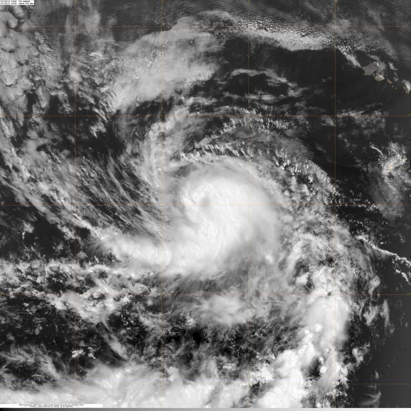
Blown Away wrote:http://img856.imageshack.us/img856/1006/svz7.jpg
12z...LGEM brings Dorian to Cat 2...Most intensity models now keep Dorian as strong TS or Cat 1...Big shift from 06z...


The more time goes by, the more they assume shear/winds/etc aren't going to be 'as' strong or effective as originally thought,
0 likes   
The posts in this forum are NOT official forecast and should not be used as such. They are just the opinion of the poster and may or may not be backed by sound meteorological data. They are NOT endorsed by any professional institution or storm2k.org. For official information, please refer to the NHC and NWS products.

User avatar
galaxy401
Category 5
Category 5
Posts: 2419
Age: 30
Joined: Sat Aug 25, 2012 9:04 pm
Location: Casa Grande, Arizona

#540 Postby galaxy401 » Wed Jul 24, 2013 10:00 am

The Public Advisory and Discussion still isn't out yet despite it showing it is out on the website...
0 likes   
Got my eyes on moving right into Hurricane Alley: Florida.


Return to “2013”

Who is online

Users browsing this forum: No registered users and 6 guests