ATL: DORIAN - Post-Tropical - Discussion
Moderator: S2k Moderators
-
meriland23

- Category 5

- Posts: 1239
- Age: 38
- Joined: Mon Aug 29, 2011 9:29 pm
it is booking its rotation speed insanely rapidly, so maybe the reason for this supposed eyewall?
0 likes
The posts in this forum are NOT official forecast and should not be used as such. They are just the opinion of the poster and may or may not be backed by sound meteorological data. They are NOT endorsed by any professional institution or storm2k.org. For official information, please refer to the NHC and NWS products.


-
tolakram
- Admin

- Posts: 20186
- Age: 62
- Joined: Sun Aug 27, 2006 8:23 pm
- Location: Florence, KY (name is Mark)
Re: ATL: FOUR - Tropical Depression - Discussion
13:15Z (that's 9:15AM EDT)

0 likes
M a r k
- - - - -
Join us in chat: Storm2K Chatroom Invite. Android and IOS apps also available.
The posts in this forum are NOT official forecasts and should not be used as such. Posts are NOT endorsed by any professional institution or STORM2K.org. For official information and forecasts, please refer to NHC and NWS products.


-
meriland23
- Category 5
- Posts: 1239
- Age: 38
- Joined: Mon Aug 29, 2011 9:29 pm
Re:
RL3AO wrote:Might be watching the strangest two hours of the entire season.
Was looking for the 'like' button where you posted this and realized I was not on FB.. sigh.. well I agree with ya~
0 likes
The posts in this forum are NOT official forecast and should not be used as such. They are just the opinion of the poster and may or may not be backed by sound meteorological data. They are NOT endorsed by any professional institution or storm2k.org. For official information, please refer to the NHC and NWS products.
-
tolakram
- Admin
- Posts: 20186
- Age: 62
- Joined: Sun Aug 27, 2006 8:23 pm
- Location: Florence, KY (name is Mark)
Re: ATL: FOUR - Tropical Depression - Discussion
Next image will be the 13:45Z, but the FTP site is running about 25 minutes behind.
ftp://goes.gsfc.nasa.gov/pub/goeseast/overview2/vis/
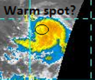
I was hoping to get better clarity from the latest, but I'm just not sure. The eye like feature looks like an eye, but there appears to be either shear or dry air, or both, impinging on the SW quadrant.
ftp://goes.gsfc.nasa.gov/pub/goeseast/overview2/vis/
I was hoping to get better clarity from the latest, but I'm just not sure. The eye like feature looks like an eye, but there appears to be either shear or dry air, or both, impinging on the SW quadrant.
0 likes
M a r k
- - - - -
Join us in chat: Storm2K Chatroom Invite. Android and IOS apps also available.
The posts in this forum are NOT official forecasts and should not be used as such. Posts are NOT endorsed by any professional institution or STORM2K.org. For official information and forecasts, please refer to NHC and NWS products.
- - - - -
Join us in chat: Storm2K Chatroom Invite. Android and IOS apps also available.
The posts in this forum are NOT official forecasts and should not be used as such. Posts are NOT endorsed by any professional institution or STORM2K.org. For official information and forecasts, please refer to NHC and NWS products.

Re: ATL: FOUR - Tropical Depression - Discussion
Small systems like this can change intensity rather quickly (upwards and downwards)...doubt it's a hurricane, but it certainly intensifying faster than the NHC forecasted. It is moving a bit north of forecast, however, which may mean it would traverse more "cooler" waters...which could possibly keep it in check.
0 likes
-
hurricanekid416
- Tropical Storm

- Posts: 179
- Joined: Wed Oct 24, 2012 2:43 pm
If this was September this may be like hurricane ike in terms of track
0 likes
Personal Forecast Disclaimer:
The posts in this forum are NOT official forecast and should not be used as such. They are just the opinion of the poster and may or may not be backed by sound meteorological data. They are NOT endorsed by any professional institution or storm2k.org. For official information, please refer to the NHC and NWS products.
The posts in this forum are NOT official forecast and should not be used as such. They are just the opinion of the poster and may or may not be backed by sound meteorological data. They are NOT endorsed by any professional institution or storm2k.org. For official information, please refer to the NHC and NWS products.
-
vbhoutex

- Storm2k Executive
- Posts: 29150
- Age: 74
- Joined: Wed Oct 09, 2002 11:31 pm
- Location: Cypress, TX
- Contact:
Re:
hurricanekid416 wrote:If this was September this may be like hurricane ike in terms of track
Why do you think that?
0 likes
Skywarn, C.E.R.T.
Please click below to donate to STORM2K to help with the expenses of keeping the site going:

Please click below to donate to STORM2K to help with the expenses of keeping the site going:
-
tolakram
- Admin
- Posts: 20186
- Age: 62
- Joined: Sun Aug 27, 2006 8:23 pm
- Location: Florence, KY (name is Mark)
Re: ATL: FOUR - Tropical Depression - Discussion
Looking at the visible loop from this page: http://rammb.cira.colostate.edu/product ... r=AL042013
And considering best track moved up TS formation to early this morning I would not be surprised if this is a strong TS at this point, undergoing RI. It just looks too darn good to be an illusion.
Personal Forecast Disclaimer:
The posts in this forum are NOT official forecast and should not be used as such. They are just the opinion of the poster and may or may not be backed by sound meteorological data. They are NOT endorsed by any professional institution or storm2k.org. For official information, please refer to the NHC and NWS products.
0 likes
M a r k
- - - - -
Join us in chat: Storm2K Chatroom Invite. Android and IOS apps also available.
The posts in this forum are NOT official forecasts and should not be used as such. Posts are NOT endorsed by any professional institution or STORM2K.org. For official information and forecasts, please refer to NHC and NWS products.
- - - - -
Join us in chat: Storm2K Chatroom Invite. Android and IOS apps also available.
The posts in this forum are NOT official forecasts and should not be used as such. Posts are NOT endorsed by any professional institution or STORM2K.org. For official information and forecasts, please refer to NHC and NWS products.
-
otowntiger
- Category 5
- Posts: 1932
- Joined: Tue Aug 31, 2004 7:06 pm
Re: ATL: TROPICAL DEPRESSION 4 - Discussion
jlauderdal wrote:ronjon wrote:meriland23 wrote:Do you guys think it will be a GOMer, ECer, or a fish... IYO[/quote
Strong Atlantic ridging forecast to remain over the next week by the global models. Too early to say but at least for now doesn't look likely to recurve into the open Atlantic.
long runner looks probable, been awhile since we had a long runner make it all the way across, its rather uncommon
Certainly is possible, but even with the models suggesting its path could come all the way across the chances are still less than 50/50 (inmho) just because its so rare. The other, perhaps bigger question is what kind of intensity will be looking at? It seems that at this point guidance tells us it may not be that potent by the time it gets closer to the Islands, but I know things can and will change.
Personal Forecast Disclaimer:
The posts in this forum are NOT official forecast and should not be used as such. They are just the opinion of the poster and may or may not be backed by sound meteorological data. They are NOT endorsed by any professional institution or storm2k.org. For official information, please refer to the NHC and NWS products.
Last edited by otowntiger on Wed Jul 24, 2013 9:09 am, edited 1 time in total.
0 likes
-
hurricanekid416
- Tropical Storm
- Posts: 179
- Joined: Wed Oct 24, 2012 2:43 pm
Re: Re:
vbhoutex wrote:hurricanekid416 wrote:If this was September this may be like hurricane ike in terms of track
Why do you think that?
The models show a northerly track and then a bend west with a strong ridge and that's what ike did
0 likes
Personal Forecast Disclaimer:
The posts in this forum are NOT official forecast and should not be used as such. They are just the opinion of the poster and may or may not be backed by sound meteorological data. They are NOT endorsed by any professional institution or storm2k.org. For official information, please refer to the NHC and NWS products.
The posts in this forum are NOT official forecast and should not be used as such. They are just the opinion of the poster and may or may not be backed by sound meteorological data. They are NOT endorsed by any professional institution or storm2k.org. For official information, please refer to the NHC and NWS products.
-
northjaxpro

- S2K Supporter

- Posts: 8900
- Joined: Mon Sep 27, 2010 11:21 am
- Location: Jacksonville, FL
0 likes
NEVER, EVER SAY NEVER in the tropics and weather in general, and most importantly, with life itself!!
________________________________________________________________________________________
Fay 2008 Beryl 2012 Debby 2012 Colin 2016 Hermine 2016 Julia 2016 Matthew 2016 Irma 2017 Dorian 2019
________________________________________________________________________________________
Fay 2008 Beryl 2012 Debby 2012 Colin 2016 Hermine 2016 Julia 2016 Matthew 2016 Irma 2017 Dorian 2019
Re: ATL: FOUR - Tropical Depression - Discussion
This is currently a pretty small system, the intensity swings could get pretty crazy, in both directions, for a while.
0 likes


-
tolakram
- Admin
- Posts: 20186
- Age: 62
- Joined: Sun Aug 27, 2006 8:23 pm
- Location: Florence, KY (name is Mark)
Re: ATL: FOUR - Tropical Depression - Discussion
13:45Z

0 likes
M a r k
- - - - -
Join us in chat: Storm2K Chatroom Invite. Android and IOS apps also available.
The posts in this forum are NOT official forecasts and should not be used as such. Posts are NOT endorsed by any professional institution or STORM2K.org. For official information and forecasts, please refer to NHC and NWS products.
- - - - -
Join us in chat: Storm2K Chatroom Invite. Android and IOS apps also available.
The posts in this forum are NOT official forecasts and should not be used as such. Posts are NOT endorsed by any professional institution or STORM2K.org. For official information and forecasts, please refer to NHC and NWS products.
Who is online
Users browsing this forum: No registered users and 48 guests