ATL: DORIAN - Post-Tropical - Discussion
Moderator: S2k Moderators
-
meriland23

- Category 5

- Posts: 1239
- Age: 38
- Joined: Mon Aug 29, 2011 9:29 pm
How could it be forming a eyewall yet? It is just born...
0 likes
The posts in this forum are NOT official forecast and should not be used as such. They are just the opinion of the poster and may or may not be backed by sound meteorological data. They are NOT endorsed by any professional institution or storm2k.org. For official information, please refer to the NHC and NWS products.


-
meriland23
- Category 5
- Posts: 1239
- Age: 38
- Joined: Mon Aug 29, 2011 9:29 pm
Re:
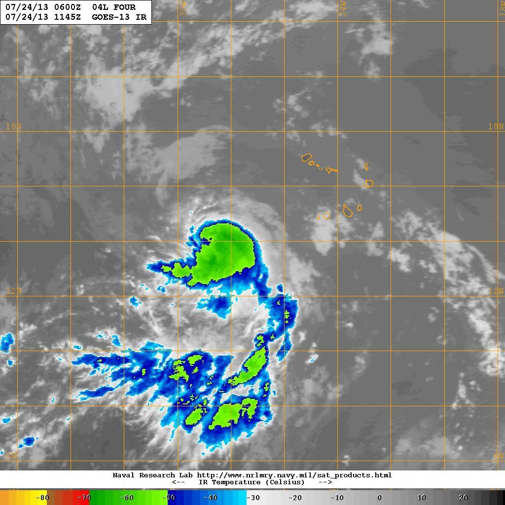
gatorcane wrote:Amazing, that certainly looks like an eye-like feature to me. Here is the latest VIS shot which shows this:
[img ]http://img46.imageshack.us/img46/6199/zo3u.jpg[/img]
Could be just a pocket of dry air or something right?
0 likes
The posts in this forum are NOT official forecast and should not be used as such. They are just the opinion of the poster and may or may not be backed by sound meteorological data. They are NOT endorsed by any professional institution or storm2k.org. For official information, please refer to the NHC and NWS products.


At 1200 UTC, 24 July 2013, TROPICAL STORM DORIAN (AL04) was located in the North Atlantic basin at 14.0°N and 29°W. The current intensity was 35 kt and the center was moving at 18 kt at a bearing of 285 degrees. The minimum central pressure was 1006 mb.
http://www.ral.ucar.edu/guidance/realti ... /al042013/
http://www.ral.ucar.edu/guidance/realti ... /al042013/
Last edited by NDG on Wed Jul 24, 2013 8:19 am, edited 1 time in total.
0 likes
-
northjaxpro

- S2K Supporter

- Posts: 8900
- Joined: Mon Sep 27, 2010 11:21 am
- Location: Jacksonville, FL
Yeah, gatorcane, the more I view the imagery and the approximate LLC location, it does look more like an eye beginning to form. We may be wrong in assuming that, but I have been tracking these cyclones for years, and right now it sure does look like a one is forming. We will know soon enough.
Last edited by northjaxpro on Wed Jul 24, 2013 8:15 am, edited 1 time in total.
0 likes
NEVER, EVER SAY NEVER in the tropics and weather in general, and most importantly, with life itself!!
________________________________________________________________________________________
Fay 2008 Beryl 2012 Debby 2012 Colin 2016 Hermine 2016 Julia 2016 Matthew 2016 Irma 2017 Dorian 2019
________________________________________________________________________________________
Fay 2008 Beryl 2012 Debby 2012 Colin 2016 Hermine 2016 Julia 2016 Matthew 2016 Irma 2017 Dorian 2019
-
tolakram
- Admin

- Posts: 20186
- Age: 62
- Joined: Sun Aug 27, 2006 8:23 pm
- Location: Florence, KY (name is Mark)
Re:
NDG wrote:At 1200 UTC, 24 July 2013, TROPICAL STORM DORIAN (AL04) was located in the North Atlantic basin at 14.0°N and 29°W. The current intensity was 35 kt and the center was moving at 18 kt at a bearing of 285 degrees. The minimum central pressure was 1006 mb.
Source?
0 likes
M a r k
- - - - -
Join us in chat: Storm2K Chatroom Invite. Android and IOS apps also available.
The posts in this forum are NOT official forecasts and should not be used as such. Posts are NOT endorsed by any professional institution or STORM2K.org. For official information and forecasts, please refer to NHC and NWS products.
Re: Re:
tolakram wrote:NDG wrote:At 1200 UTC, 24 July 2013, TROPICAL STORM DORIAN (AL04) was located in the North Atlantic basin at 14.0°N and 29°W. The current intensity was 35 kt and the center was moving at 18 kt at a bearing of 285 degrees. The minimum central pressure was 1006 mb.
Source?
This is the position & strength the 12z tropical models were started.
http://www.ral.ucar.edu/guidance/realti ... /al042013/
0 likes
-
meriland23
- Category 5
- Posts: 1239
- Age: 38
- Joined: Mon Aug 29, 2011 9:29 pm
Re:
gatorcane wrote:Amazing, that certainly looks like an eye-like feature to me. Here is the latest VIS shot which shows this:
http://img46.imageshack.us/img46/6199/zo3u.jpg
Does not make sense, how could it possibly, aren't eyewalls a feature of a M hurricane?
0 likes
The posts in this forum are NOT official forecast and should not be used as such. They are just the opinion of the poster and may or may not be backed by sound meteorological data. They are NOT endorsed by any professional institution or storm2k.org. For official information, please refer to the NHC and NWS products.
Re: Re:
meriland23 wrote:gatorcane wrote:
Does not make sense, how could it possibly, aren't eyewalls a feature of a M hurricane?
Eyewalls typically being to form on strong tropical storms. However, I'm quite skeptical that this is an eye wall. I'm betting on an illusion.
0 likes
-
wxman57

- Moderator-Pro Met

- Posts: 23175
- Age: 68
- Joined: Sat Jun 21, 2003 8:06 pm
- Location: Houston, TX (southwest)
Re: ATL: FOUR - Tropical Depression - Discussion
New model guidance has 14N/29W and 45 kts. Agree with that intensity estimate.
0 likes
-
meriland23
- Category 5
- Posts: 1239
- Age: 38
- Joined: Mon Aug 29, 2011 9:29 pm
Re: ATL: FOUR - Tropical Depression - Discussion
wxman57 wrote:New model guidance has 14N/29W and 45 kts. Agree with that intensity estimate.
hmph.. 35 kts to 45 kts in the blink of a eye? Well that is interesting..
0 likes
The posts in this forum are NOT official forecast and should not be used as such. They are just the opinion of the poster and may or may not be backed by sound meteorological data. They are NOT endorsed by any professional institution or storm2k.org. For official information, please refer to the NHC and NWS products.
-
tolakram
- Admin
- Posts: 20186
- Age: 62
- Joined: Sun Aug 27, 2006 8:23 pm
- Location: Florence, KY (name is Mark)
Re: ATL: FOUR - Tropical Depression - Discussion
12:45Z

0 likes
M a r k
- - - - -
Join us in chat: Storm2K Chatroom Invite. Android and IOS apps also available.
The posts in this forum are NOT official forecasts and should not be used as such. Posts are NOT endorsed by any professional institution or STORM2K.org. For official information and forecasts, please refer to NHC and NWS products.
- - - - -
Join us in chat: Storm2K Chatroom Invite. Android and IOS apps also available.
The posts in this forum are NOT official forecasts and should not be used as such. Posts are NOT endorsed by any professional institution or STORM2K.org. For official information and forecasts, please refer to NHC and NWS products.
-
meriland23
- Category 5
- Posts: 1239
- Age: 38
- Joined: Mon Aug 29, 2011 9:29 pm
Re: ATL: FOUR - Tropical Depression - Discussion
tolakram wrote:12:45Z
[img ]http://imageshack.us/a/img23/3285/6sf1.jpg[/img]
that sure looks like a eye to me...
0 likes
The posts in this forum are NOT official forecast and should not be used as such. They are just the opinion of the poster and may or may not be backed by sound meteorological data. They are NOT endorsed by any professional institution or storm2k.org. For official information, please refer to the NHC and NWS products.
A few things to note from the 12z SHIPS guidance.
It shows that the coolest SSTs Dorian will track through is near 25.3 deg C over later today and tomorrow morning by tomorrow evening it should be back over 26 deg C waters and warmer as it keeps tracking westward.
Shear will be under 10 knots over the next 36 hrs and to slowly increase to near 20 knots by Sunday morning, definitely not strong enough shear to destroy it.
The only thing that I see that looks like it will negatively encounter is dry air by 72 hrs where it shows 700-500 mb RH to get down to low 40s.
0 likes
-
tolakram
- Admin
- Posts: 20186
- Age: 62
- Joined: Sun Aug 27, 2006 8:23 pm
- Location: Florence, KY (name is Mark)
Re: ATL: FOUR - Tropical Depression - Discussion
MIMIC-TPW shows a decent moisture envelope, and good spin.
http://tropic.ssec.wisc.edu/real-time/m ... /main.html
http://tropic.ssec.wisc.edu/real-time/m ... /main.html
0 likes
M a r k
- - - - -
Join us in chat: Storm2K Chatroom Invite. Android and IOS apps also available.
The posts in this forum are NOT official forecasts and should not be used as such. Posts are NOT endorsed by any professional institution or STORM2K.org. For official information and forecasts, please refer to NHC and NWS products.
- - - - -
Join us in chat: Storm2K Chatroom Invite. Android and IOS apps also available.
The posts in this forum are NOT official forecasts and should not be used as such. Posts are NOT endorsed by any professional institution or STORM2K.org. For official information and forecasts, please refer to NHC and NWS products.
-
Aric Dunn
- Category 5
- Posts: 21238
- Age: 43
- Joined: Sun Sep 19, 2004 9:58 pm
- Location: Ready for the Chase.
- Contact:
dont think its a dry slot they typically fade quickly. i am on.my.phone but i guess will have to wait for a better microwave image.. or the next couple hours see if that feature persists
0 likes
Note: If I make a post that is brief. Please refer back to previous posts for the analysis or reasoning. I do not re-write/qoute what my initial post said each time.
If there is nothing before... then just ask
Space & Atmospheric Physicist, Embry-Riddle Aeronautical University,
I believe the sky is falling...
If there is nothing before... then just ask
Space & Atmospheric Physicist, Embry-Riddle Aeronautical University,
I believe the sky is falling...
-
Chris_in_Tampa
- Category 5
- Posts: 5101
- Age: 42
- Joined: Thu Jun 21, 2007 11:06 pm
- Location: Tampa, Florida, USA
- Contact:
Best track data was updated to reflect the storm becoming a tropical storm at 2am EDT this morning:
AL, 04, 2013072406, , BEST, 0, 136N, 272W, 35, 1006, TS, 34, NEQ, 30, 0, 0, 30, 1012, 150, 30, 40, 0, L, 0, , 0, 0, FOUR, M,
AL, 04, 2013072412, , BEST, 0, 140N, 290W, 45, 1002, TS, 34, NEQ, 40, 30, 0, 30, 1012, 150, 20, 0, 0, L, 0, , 0, 0, DORIAN, D,
AL, 04, 2013072406, , BEST, 0, 136N, 272W, 35, 1006, TS, 34, NEQ, 30, 0, 0, 30, 1012, 150, 30, 40, 0, L, 0, , 0, 0, FOUR, M,
AL, 04, 2013072412, , BEST, 0, 140N, 290W, 45, 1002, TS, 34, NEQ, 40, 30, 0, 30, 1012, 150, 20, 0, 0, L, 0, , 0, 0, DORIAN, D,
0 likes
Who is online
Users browsing this forum: No registered users and 91 guests