Texas Summer - 2013
Moderator: S2k Moderators
Forum rules

The posts in this forum are NOT official forecast and should not be used as such. They are just the opinion of the poster and may or may not be backed by sound meteorological data. They are NOT endorsed by any professional institution or STORM2K.

Still not seeing much from the models regarding inland rainfall from 94L, mostly confined to the coastal regions and far east Texas. Everyone else is more hit and miss pop up showers this week with deep south Texas having the best chances. Almost all of the models then sends a rebuilding 5h ridge over the plains, Texas included as we gradually get hotter. I hope they are wrong, but I fear it may be how it turns out with our luck.
0 likes
The above post and any post by Ntxw is NOT an official forecast and should not be used as such. It is just the opinion of the poster and may or may not be backed by sound meteorological data. It is NOT endorsed by any professional institution including Storm2k. For official information, please refer to NWS products.
Help support Storm2K!
-
Rgv20

- S2K Supporter

- Posts: 2466
- Age: 39
- Joined: Wed Jan 05, 2011 5:42 pm
- Location: Edinburg/McAllen Tx
0zNAM Total Rainfall forecast thru 48hrs (Monday Night) shows some decent totals in Deep South Texas 
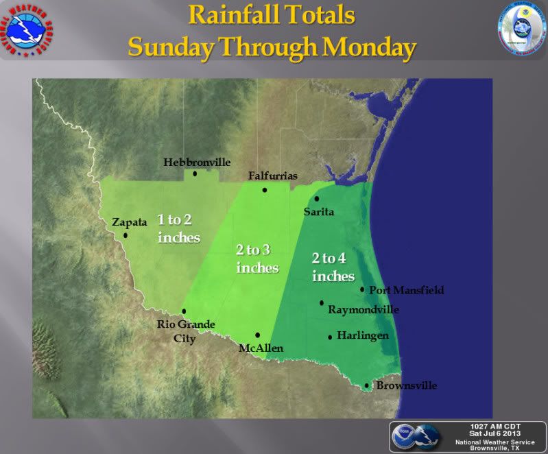
Low pressure combined with plenty of tropical moisture will work its way towards the Rio Grande Valley and Deep South Texas this weekend, increasing the chances for showers and thunderstorms across the area. Coastal counties are likely to see the greatest rainfall totals through Monday. Slower or heavier activity will have the ability to produce locally heavy rainfall with nuisance flooding in poorly draining or low-lying areas.


Low pressure combined with plenty of tropical moisture will work its way towards the Rio Grande Valley and Deep South Texas this weekend, increasing the chances for showers and thunderstorms across the area. Coastal counties are likely to see the greatest rainfall totals through Monday. Slower or heavier activity will have the ability to produce locally heavy rainfall with nuisance flooding in poorly draining or low-lying areas.
0 likes
The following post is NOT an official forecast and should not be used as such. It is just the opinion of the poster and may or may not be backed by sound meteorological data. It is NOT endorsed by any professional institution including storm2k.org For Official Information please refer to the NHC and NWS products.
-
weatherdude1108
- Category 5

- Posts: 4228
- Joined: Tue Dec 13, 2011 1:04 pm
- Location: Northwest Austin/Cedar Park, TX
I take it with a salt grain, but as of July 7th at 7:30am, for hopes sake of not letting the death ridge get us down, I noticed the Weather Channel extended for here shows 60 % chance of storms on Monday July 16th.
Weather Underground extended shows at least a 40% chance of storms starting Monday the 16th through that Wednesday.
Accuweather shows an icon of storms and showers on July 15th and 17th respectively.
Weather Underground extended shows at least a 40% chance of storms starting Monday the 16th through that Wednesday.
Accuweather shows an icon of storms and showers on July 15th and 17th respectively.
0 likes
The preceding post is NOT an official forecast, and should not be used as such. It is only the opinion of the poster and may or may not be backed by sound meteorological data. It is NOT endorsed by any professional institution including storm2k.org. For Official Information please refer to the NHC and NWS products.
-
jasons2k

- Storm2k Executive

- Posts: 8290
- Age: 52
- Joined: Wed Jul 06, 2005 12:32 pm
- Location: The Woodlands, TX
Re: Texas Summer - 2013
Somewhat (dare I say it) optimistic this morning.
I was outside for a bit, and I could see the leading edge of the moisture move-in overhead. It's a little ahead of the line of storms along US 59 on radar. Further NW, if you look close on GR2, you can make out a thin line with a shower or two from Katy to Tomball -- that's it. Anyway, that's quickly surging north (maybe a bit ore north than expected?) and it's only 8AM.
Plus, I noticed the mid-high level clouds streaming in on the southern jet. It had a slight easterly component to it - again, a good sign for rain. It's an old rule of thumb in Texas, but with the jet now having an easterly component, it will help draw in some of that moisture that's been sitting south east of us for days.
And the last thing - the radar loop. You can see the trough axis in that blob in the gulf - and today it's drifting west instead of just sitting there. It is roughly due south of Galveston and slowly drifting west. This is about to place the Houston area on the east, instead of west side of the axis.
Water vapor confirms this too - and in the last few frames a surge of moisture from the east is about to wrap-in over us. Another critical element falling into place.
All in all, after much waiting, I think it may rain today, finally.
0 likes
-
gboudx

- S2K Supporter
- Posts: 4090
- Joined: Thu Sep 04, 2003 1:39 pm
- Location: Rockwall, Tx but from Harvey, La
Encouraging thoughts from our favorite AFD author at DFW NWS:
EXTENDED...BOTH THE 07/00Z ECMWF AND GFS ADVERTISE THAT THURSDAYS
STRONG UPPER LEVEL TROUGH OVER THE GREAT LAKES REGION WILL DIG
SOUTH OVER THE SOUTHEASTERN CONUS AND BECOME CUT OFF FROM THE
NORTHERN JET STREAM NEXT WEEKEND. BOTH MODELS THEN RETROGRADE THIS
LOW TOWARDS NORTH TX BY MONDAY. THERE ARE BIG DIFFERENCES BETWEEN
THE MODELS REGARDING THIS EVOLUTION...BUT THEY BOTH RETROGRADE AN
UPPER LOW TOWARDS US FOR THE BEGINNING OF NEXT WEEK. IF ONE OF
THESE MODELS VERIFIES...WOULD LIKELY HAVE TO INCLUDE SOME 20 TO 30
POPS ACROSS MOST OF THE CWA ON MONDAY OR MONDAY NIGHT IN LATER
FORECASTS. IF THIS ACTUALLY PANS OUT THEN WE WOULD ALSO LIKELY SEE
A RETURN TO BELOW NORMAL TEMPERATURES WHICH IS USUALLY WELCOMED BY
MOST DURING JULY IN TEXAS. THIS SOLUTION MAY CHANGE SIGNIFICANTLY
BY NEXT WEEKEND...BUT IT IS CERTAINLY WORTH WATCHING AS IT COULD
SIGNIFY A BIG PATTERN CHANGE IN 7-8 DAYS.
CAVANAUGH
0 likes
-
Portastorm

- Storm2k Moderator

- Posts: 9955
- Age: 63
- Joined: Fri Jul 11, 2003 9:16 am
- Location: Round Rock, TX
- Contact:
Re: Texas Summer - 2013
The late Sunday morning Gulf water vapor loop offers some "promise" for SE Texas as a surge of moisture is heading your way. Unfortunately, that moisture surge appears to be headed east of those of us in the I-35 corridor. I'm so bummed that 94L didn't turn into a prodigious rainmaker for us.
The horrific drought continues ...
The horrific drought continues ...
0 likes
Any forecasts under my name are to be taken with a grain of salt. Get your best forecasts from the National Weather Service and National Hurricane Center.
-
Tireman4

- S2K Supporter
- Posts: 5903
- Age: 60
- Joined: Fri Jun 30, 2006 1:08 pm
- Location: Humble, Texas
- Contact:
Re: Texas Summer - 2013
Portastorm wrote:The late Sunday morning Gulf water vapor loop offers some "promise" for SE Texas as a surge of moisture is heading your way. Unfortunately, that moisture surge appears to be headed east of those of us in the I-35 corridor. I'm so bummed that 94L didn't turn into a prodigious rainmaker for us.
The horrific drought continues ...
Second. Worst. Summer. Ever.
0 likes
-
Tireman4
- S2K Supporter
- Posts: 5903
- Age: 60
- Joined: Fri Jun 30, 2006 1:08 pm
- Location: Humble, Texas
- Contact:
There is light at the end of the tunnel for some of us....
From HGX morning discussion...
.UPDATE...
SCATTERED LIGHT SHOWERS TO COME ONSHORE THROUGH THE REMAINDER OF
THE MORNING...NO MORE THAN A FEW HUNDREDTHS TO A TENTH OF AN INCH
OF ACCUMULATION FROM MANY OF THESE QUICKLY NORTH-PASSING CELLS. AS
THE DAY HEATS UP INTO THE 90S...THIS 2 INCH PWAT AIR MASS OVER THE
COASTAL COUNTIES WILL CONTINUE TO CREEP FURTHER INLAND SO EXPECTING
PRECIPITATION TO BETTER FILL IN THROUGH THE EARLY EVENING. PROG
SOUNDINGS SHOW A NEAR-SATURATED COLUMN AS FAR NORTH AS THE CITY
BY TOMORROW MORNING. THUS...FEEL THAT AT LEAST HIGH END CHANCE
POPS ARE WARRANTED THROUGH TOMORROW AFTERNOON. WARM PROFILES MAKE
FOR SKINNY CAPES...LIMITED STORM COVERAGE. RELATIVELY LOWER AREAWIDE
(OVERALL) QPF DUE TO THE WIDELY-SCATTERED NATURE ON CONVECTION...
LOCALIZED POCKETS OF OVER AN INCH OVER THE SOUTHERN THIRD OF THE
CWA IS STILL NOT OUT OF THE QUESTION. 31
0 likes
Re:
gboudx wrote:Encouraging thoughts from our favorite AFD author at DFW NWS:EXTENDED...BOTH THE 07/00Z ECMWF AND GFS ADVERTISE THAT THURSDAYS
STRONG UPPER LEVEL TROUGH OVER THE GREAT LAKES REGION WILL DIG
SOUTH OVER THE SOUTHEASTERN CONUS AND BECOME CUT OFF FROM THE
NORTHERN JET STREAM NEXT WEEKEND. BOTH MODELS THEN RETROGRADE THIS
LOW TOWARDS NORTH TX BY MONDAY. THERE ARE BIG DIFFERENCES BETWEEN
THE MODELS REGARDING THIS EVOLUTION...BUT THEY BOTH RETROGRADE AN
UPPER LOW TOWARDS US FOR THE BEGINNING OF NEXT WEEK. IF ONE OF
THESE MODELS VERIFIES...WOULD LIKELY HAVE TO INCLUDE SOME 20 TO 30
POPS ACROSS MOST OF THE CWA ON MONDAY OR MONDAY NIGHT IN LATER
FORECASTS. IF THIS ACTUALLY PANS OUT THEN WE WOULD ALSO LIKELY SEE
A RETURN TO BELOW NORMAL TEMPERATURES WHICH IS USUALLY WELCOMED BY
MOST DURING JULY IN TEXAS. THIS SOLUTION MAY CHANGE SIGNIFICANTLY
BY NEXT WEEKEND...BUT IT IS CERTAINLY WORTH WATCHING AS IT COULD
SIGNIFY A BIG PATTERN CHANGE IN 7-8 DAYS.
CAVANAUGH
I noticed this from the late runs of the Euro. Given the fact that a constant eastern conus trough has been persistent this summer and how heat ridges have not survived over us this is certainly a very plausible scenario. I think the cooler temps are probably a given due to the nature of retrograding patterns and unusual power of the trofs, but we need more rain. Come on tropics!
We just had anomalous low heights over the region, another one looks like in the works after the heat wave.
0 likes
The above post and any post by Ntxw is NOT an official forecast and should not be used as such. It is just the opinion of the poster and may or may not be backed by sound meteorological data. It is NOT endorsed by any professional institution including Storm2k. For official information, please refer to NWS products.
Help support Storm2K!
Help support Storm2K!
-
South Texas Storms

- Professional-Met

- Posts: 4260
- Joined: Thu Jun 24, 2010 12:28 am
- Location: Houston, TX
Re: Texas Summer - 2013
Portastorm wrote:The late Sunday morning Gulf water vapor loop offers some "promise" for SE Texas as a surge of moisture is heading your way. Unfortunately, that moisture surge appears to be headed east of those of us in the I-35 corridor. I'm so bummed that 94L didn't turn into a prodigious rainmaker for us.
The horrific drought continues ...
Our best chance of rain is tomorrow Porta. I think we will see scattered tropical showers in our area tomorrow afternoon.
0 likes
-
weatherdude1108
- Category 5
- Posts: 4228
- Joined: Tue Dec 13, 2011 1:04 pm
- Location: Northwest Austin/Cedar Park, TX
Not all hope is lost Porta. 
Around 6:20pm last night, a tropical shower (HUGE drops) fell at the Weatherdude Center. Lasted less than 5 minutes. The electronic gauge did not measure anything.
But, the plus side, it dropped from 96 to 87 at my place in one hour! Also went from 38% humidity to 60% humidity during same time. Humidity is good for rain chances.
Bring on the rain all Summer IMO!! Would be so nice, like in 2007 (WET Summer here) when lakes and aquifers got full. Last time they had to open flood gates at Lake Travis (I think.).

Is that right Porta? Anyway. Looking forward to what the day, and the extended forecast models mention about a highly unusual cutoff low pressure trough alledgedly moving in from the northeast towards Texas(?). I don't know anything about it. Maybe others have more insight into it, if it's even true, or just another mirage.
Around 6:20pm last night, a tropical shower (HUGE drops) fell at the Weatherdude Center. Lasted less than 5 minutes. The electronic gauge did not measure anything.
But, the plus side, it dropped from 96 to 87 at my place in one hour! Also went from 38% humidity to 60% humidity during same time. Humidity is good for rain chances.
Bring on the rain all Summer IMO!! Would be so nice, like in 2007 (WET Summer here) when lakes and aquifers got full. Last time they had to open flood gates at Lake Travis (I think.).
Is that right Porta? Anyway. Looking forward to what the day, and the extended forecast models mention about a highly unusual cutoff low pressure trough alledgedly moving in from the northeast towards Texas(?). I don't know anything about it. Maybe others have more insight into it, if it's even true, or just another mirage.
0 likes
The preceding post is NOT an official forecast, and should not be used as such. It is only the opinion of the poster and may or may not be backed by sound meteorological data. It is NOT endorsed by any professional institution including storm2k.org. For Official Information please refer to the NHC and NWS products.
-
Portastorm
- Storm2k Moderator
- Posts: 9955
- Age: 63
- Joined: Fri Jul 11, 2003 9:16 am
- Location: Round Rock, TX
- Contact:
Re: Texas Summer - 2013
Upper level low retrograding into Texas ... increased rain chances ... blah, blah, blah. 
No offense but I've heard this before and it didn't verify. Will believe it when I see it. Meanwhile, the sprinkler system at the Portastorm Weather Center had an active workout last night.
I'm hopeful the active radar returns to our southeast this morning will offer a little liquid happiness for us.
0 likes
Any forecasts under my name are to be taken with a grain of salt. Get your best forecasts from the National Weather Service and National Hurricane Center.
-
Portastorm
- Storm2k Moderator
- Posts: 9955
- Age: 63
- Joined: Fri Jul 11, 2003 9:16 am
- Location: Round Rock, TX
- Contact:
Re:
Tireman4 wrote:Tis raining here in the Gulfgate area of Houston. Tee hee.
I think it's about time you received a week's "vacation" from Storm2K with a nice suspension. How does that sound?!
OK, seriously, to answer weatherdude's previous question ... the last time floodgates were opened on the Highland Lakes was back in September 2010, courtesy of Tropical Depression Hermine.
0 likes
Any forecasts under my name are to be taken with a grain of salt. Get your best forecasts from the National Weather Service and National Hurricane Center.
-
Tireman4
- S2K Supporter
- Posts: 5903
- Age: 60
- Joined: Fri Jun 30, 2006 1:08 pm
- Location: Humble, Texas
- Contact:
Re: Re:
Portastorm wrote:Tireman4 wrote:Tis raining here in the Gulfgate area of Houston. Tee hee.
I think it's about time you received a week's "vacation" from Storm2K with a nice suspension. How does that sound?!
Well fine, I am out the door. I will take the rain with me. The Elders will blame you. LOL ha ha ha...
0 likes
Meh, we need a tropical system to sit over Texas maybe even two. That is the only way we are going to get out of this long term drought. No trough or mid-latitude storm is going to do it, they only give short term relief. Cooler temps are nice from the lows due to height falls but with no El Nino in the near (or distant see-able future) there's just nothing that will end this multi-year drought completely. We have gone nearly 3 years straight with no Nino and the past 6 years we've had one, it's not going to cut it.
0 likes
The above post and any post by Ntxw is NOT an official forecast and should not be used as such. It is just the opinion of the poster and may or may not be backed by sound meteorological data. It is NOT endorsed by any professional institution including Storm2k. For official information, please refer to NWS products.
Help support Storm2K!
Help support Storm2K!
-
Portastorm
- Storm2k Moderator
- Posts: 9955
- Age: 63
- Joined: Fri Jul 11, 2003 9:16 am
- Location: Round Rock, TX
- Contact:
Re: Re:
Tireman4 wrote:Portastorm wrote:Tireman4 wrote:Tis raining here in the Gulfgate area of Houston. Tee hee.
I think it's about time you received a week's "vacation" from Storm2K with a nice suspension. How does that sound?!
Well fine, I am out the door. I will take the rain with me. The Elders will blame you. LOL ha ha ha...
Well ... nanny-nanny-boo-boo, guess what? It's raining in downtown Austin! Yipee!
I promise this will be the last of my inane postings (at least for today).
0 likes
Any forecasts under my name are to be taken with a grain of salt. Get your best forecasts from the National Weather Service and National Hurricane Center.
-
Tireman4
- S2K Supporter
- Posts: 5903
- Age: 60
- Joined: Fri Jun 30, 2006 1:08 pm
- Location: Humble, Texas
- Contact:
Re: Re:
[
Well fine, I am out the door. I will take the rain with me. The Elders will blame you. LOL ha ha ha...[/quote]
Well ... nanny-nanny-boo-boo, guess what? It's raining in downtown Austin! Yipee!
I promise this will be the last of my inane postings (at least for today).[/quote]
Well ok. Now, you need to tell the mets at the PWC I want snow dadgummit. Thanks.
0 likes
Re: Re:
Tireman4 wrote:Well ok. Now, you need to tell the mets at the PWC I want snow dadgummit. Thanks.
You want it? You got it! I'm sure Portastorm is working on a Feb 1895 repeat for Houston in a few months no strings attached.
0 likes
The above post and any post by Ntxw is NOT an official forecast and should not be used as such. It is just the opinion of the poster and may or may not be backed by sound meteorological data. It is NOT endorsed by any professional institution including Storm2k. For official information, please refer to NWS products.
Help support Storm2K!
Help support Storm2K!
-
Tireman4
- S2K Supporter
- Posts: 5903
- Age: 60
- Joined: Fri Jun 30, 2006 1:08 pm
- Location: Humble, Texas
- Contact:
Re: Re:
Ntxw wrote:Tireman4 wrote:Well ok. Now, you need to tell the mets at the PWC I want snow dadgummit. Thanks.
You want it? You got it! I'm sure Portastorm is working on a Feb 1895 repeat for Houston in a few months no strings attached.
Well, I would be happy with 20 inches. Wxman 57, not so much. LOL.
0 likes
Return to “USA & Caribbean Weather”
Who is online
Users browsing this forum: No registered users and 94 guests