ATL: CHANTAL - Post-Tropical

Moderator: S2k Moderators

Message
Author
User avatar
NDG
S2K Supporter
S2K Supporter
Posts: 15446
Joined: Sun Jul 09, 2006 10:14 pm
Location: Orlando, FL

Re: Re:

#601 Postby NDG » Sun Jul 07, 2013 11:52 pm

cycloneye wrote:
SouthDadeFish wrote:Looking better on this recent TRMM pass than earlier today:

http://img5.imageshack.us/img5/3855/ptl7.jpg

http://img27.imageshack.us/img27/5092/3b56.jpg


Wow,much better yes.


This is probably the pass that made the NHC upgrade it.
0 likes   

User avatar
SouthDadeFish
Professional-Met
Professional-Met
Posts: 2835
Joined: Thu Sep 23, 2010 2:54 pm
Location: Miami, FL
Contact:

#602 Postby SouthDadeFish » Sun Jul 07, 2013 11:53 pm

From what I've gathered and from SHIPS data, conditions due appear relatively favorable for intensification over the next 24-36 hours. After this time wind shear will start to increase. If Chantal can somehow manage to develop an organized inner core before wind shear starts to increase, I think she may be able to handle the shear a little better. It will definitely be an interesting storm to watch. For our friends in the islands, I certainly hope wind shear keeps this thing in check.
0 likes   

SapphireSea
Category 1
Category 1
Posts: 430
Joined: Wed Aug 24, 2005 12:13 pm
Location: Miami, FL

Re:

#603 Postby SapphireSea » Sun Jul 07, 2013 11:55 pm

SouthDadeFish wrote:From what I've gathered and from SHIPS data, conditions due appear relatively favorable for intensification over the next 24-36 hours. After this time wind shear will start to increase. If Chantal can somehow manage to develop an organized inner core before wind shear starts to increase, I think she may be able to handle the shear a little better. It will definitely be an interesting storm to watch. For our friends in the islands, I certainly hope wind shear keeps this thing in check.


I've been a bit concerned about the short-term strengthening of the storm. Hopefully as you say that the Dry environment and/or shear help keep it in check.
0 likes   
Forecast Disclaimer:

Don't be stupid. Make your own informed decisions.

User avatar
TropicalAnalystwx13
Category 5
Category 5
Posts: 2109
Age: 27
Joined: Tue Jul 19, 2011 8:20 pm
Location: Wilmington, NC
Contact:

#604 Postby TropicalAnalystwx13 » Sun Jul 07, 2013 11:55 pm

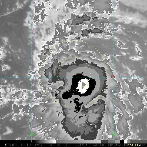
It's strange to see a 35kt. tropical storm developing an eyewall. Guess that central dense overcast did it.

Will be interesting to see what recon finds tomorrow
0 likes   

User avatar
NDG
S2K Supporter
S2K Supporter
Posts: 15446
Joined: Sun Jul 09, 2006 10:14 pm
Location: Orlando, FL

Re: ATL: CHANTAL - Tropical Storm - Discussion

#605 Postby NDG » Sun Jul 07, 2013 11:55 pm

Evil Jeremy wrote:
meriland23 wrote:
TexasF6 wrote:I'm not buying any model data until Recon gets in there and takes in proper data to ingest to the models. Until then, Chantal bears watching.


Does recon really have a massively significant to how the GFS models play out?


Recon, especially the Gulfstream IV flights (which are rare), contribute very useful upper atmospheric information to the models.


I would say that the Gulfstream IV atmospheric sampling flights contribute more to the models than the Hurricane Hunter flights, IMO.
0 likes   

User avatar
Rgv20
S2K Supporter
S2K Supporter
Posts: 2466
Age: 38
Joined: Wed Jan 05, 2011 5:42 pm
Location: Edinburg/McAllen Tx

#606 Postby Rgv20 » Sun Jul 07, 2013 11:56 pm

Looking rather healthy..

Image
0 likes   
The following post is NOT an official forecast and should not be used as such. It is just the opinion of the poster and may or may not be backed by sound meteorological data. It is NOT endorsed by any professional institution including storm2k.org For Official Information please refer to the NHC and NWS products.

User avatar
Jevo
S2K Supporter
S2K Supporter
Posts: 1729
Age: 47
Joined: Tue Aug 03, 2004 8:45 pm
Location: The Flemish Cap
Contact:

#607 Postby Jevo » Sun Jul 07, 2013 11:57 pm

0z NAVGEM (Formerly NOGAPS) +96

Image

0z NAVGEM (Formerly NOGAPS) +120

Image
0 likes   
Disclaimer: 50% of the time I have no clue of what I am talking about. Chances are I am taking a less than educated guess that sounds good because 10 years ago I stole Mike Watkins book 'The Hurricane and its Impact'. For official information please direct yourself to the NHC and their cadre of weather geniuses.

User avatar
AtlanticWind
S2K Supporter
S2K Supporter
Posts: 1889
Age: 66
Joined: Sun Aug 08, 2004 9:57 pm
Location: Plantation,Fla

#608 Postby AtlanticWind » Sun Jul 07, 2013 11:58 pm

Just a side note , 00 GFS brings another system towards florida after Chantal. Is this August? Did I miss A whole month :lol:
0 likes   

User avatar
cycloneye
Admin
Admin
Posts: 145332
Age: 68
Joined: Thu Oct 10, 2002 10:54 am
Location: San Juan, Puerto Rico

Re: ATL: CHANTAL - Tropical Storm - Discussion

#609 Postby cycloneye » Mon Jul 08, 2013 12:00 am

A reminder that any posts about the models for future systems may be posted at the Talking Tropics Global Models thread,thanks for your cooperation.

viewtopic.php?f=31&t=104813&hilit=&p=2316307#p2316307
0 likes   
Visit the Caribbean-Central America Weather Thread where you can find at first post web cams,radars
and observations from Caribbean basin members Click Here

User avatar
AtlanticWind
S2K Supporter
S2K Supporter
Posts: 1889
Age: 66
Joined: Sun Aug 08, 2004 9:57 pm
Location: Plantation,Fla

#610 Postby AtlanticWind » Mon Jul 08, 2013 12:01 am

So NAVGEM keeps this south of the Islands
0 likes   

User avatar
SouthDadeFish
Professional-Met
Professional-Met
Posts: 2835
Joined: Thu Sep 23, 2010 2:54 pm
Location: Miami, FL
Contact:

Re:

#611 Postby SouthDadeFish » Mon Jul 08, 2013 12:02 am

TropicalAnalystwx13 wrote:It's strange to see a 35kt. tropical storm developing an eyewall. Guess that central dense overcast did it.

Will be interesting to see what recon finds tomorrow


I'm not sure we can call it an eyewall yet. I would like to see another pass to confirm the same pattern of organization. That convective burst definitely helped though. The key now is persistence of the convection. This probably will be easier currently with the onset of diurnal maximum.
0 likes   

User avatar
Evil Jeremy
S2K Supporter
S2K Supporter
Posts: 5463
Age: 32
Joined: Mon Apr 10, 2006 2:10 pm
Location: Los Angeles, CA

Re: ATL: CHANTAL - Tropical Storm - Discussion

#612 Postby Evil Jeremy » Mon Jul 08, 2013 12:04 am

NDG wrote:
Evil Jeremy wrote:
meriland23 wrote:Does recon really have a massively significant to how the GFS models play out?


Recon, especially the Gulfstream IV flights (which are rare), contribute very useful upper atmospheric information to the models.


I would say that the Gulfstream IV atmospheric sampling flights contribute more to the models than the Hurricane Hunter flights, IMO.


Hence the "especially" distinction. The regular flights still do contribute some info though.
0 likes   
Frances 04 / Jeanne 04 / Katrina 05 / Wilma 05 / Fay 08 / Debby 12 / Andrea 13 / Colin 16 / Hermine 16 / Matthew 16 / Irma 17

User avatar
LaBreeze
Category 5
Category 5
Posts: 1497
Joined: Thu Sep 04, 2003 1:57 pm
Location: SW Louisiana

Re:

#613 Postby LaBreeze » Mon Jul 08, 2013 12:04 am

Jevo wrote:0z NAVGEM (Formerly NOGAPS) +96

Image

0z NAVGEM (Formerly NOGAPS) +120

Image


How reliable is 0z NAVGEM? Just wondering how everyone feels about that particular model.
0 likes   

User avatar
AtlanticWind
S2K Supporter
S2K Supporter
Posts: 1889
Age: 66
Joined: Sun Aug 08, 2004 9:57 pm
Location: Plantation,Fla

Re: Re:

#614 Postby AtlanticWind » Mon Jul 08, 2013 12:07 am

LaBreeze wrote:
Jevo wrote:0z NAVGEM (Formerly NOGAPS) +96

Image

0z NAVGEM (Formerly NOGAPS) +120

Image


How reliable is 0z NAVGEM? Just wondering how everyone feels about that particular model.


Not very good compared to the GFS and Euro
0 likes   

User avatar
SFLcane
S2K Supporter
S2K Supporter
Posts: 10163
Age: 47
Joined: Sat Jun 05, 2010 1:44 pm
Location: Lake Worth Florida

Re: ATL: CHANTAL - Models

#615 Postby SFLcane » Mon Jul 08, 2013 12:11 am

0 likes   

User avatar
summersquall
Tropical Storm
Tropical Storm
Posts: 230
Joined: Wed Jun 16, 2010 11:23 am
Location: Jensen Beach FL 27°N 80°W (roughly)

Re: ATL: CHANTAL - Models

#616 Postby summersquall » Mon Jul 08, 2013 12:11 am

Evil Jeremy wrote:
meriland23 wrote:
AtlanticWind wrote:It gets pretty complex once Chantal gets north of the islands, it may get blocked at some point . Intensity is also a big question.


All models agree it will just peter out whether a ridge builds or not. That it cause it will either crawl over DR or the Cuban mountains.. either way, causing it to diminish.


Not all models see death before the ridge may or may not build back in. NHC is speculating on possible dissipation (which is valid). However, many models suggest survival, including the 00z GFS.


It is way far out but the NHC currently forecasts at least a 30% chance of Chantal maintaining TS strength in the 120 hr timeframe and it will be close to the warm gulfstream waters around then so...hmmmm.
0 likes   
My posts should NEVER, EVER, EVER be construed as an official forecast as I know virtually nada respecting the finer points of meteorology. Consequently, my posts are obviously NOT endorsed by any professional institution or the good folks at storm2k.org. For official information please refer to the weather gurus at the NHC and NWS.

User avatar
Jevo
S2K Supporter
S2K Supporter
Posts: 1729
Age: 47
Joined: Tue Aug 03, 2004 8:45 pm
Location: The Flemish Cap
Contact:

Re: Re:

#617 Postby Jevo » Mon Jul 08, 2013 12:15 am

LaBreeze wrote:
Jevo wrote:0z NAVGEM (Formerly NOGAPS) +96

NAVGEM

How reliable is 0z NAVGEM? Just wondering how everyone feels about that particular model.


It's brand new, supposedly much higher resolution than the original NOGAPS that it replaced. Here is some information on the model

The Naval Research Lab (NRL) - Monterey has recently developed a new atmospheric forecast model, the NAVy Global Environmental Model (NAVGEM) to replace the existing Navy Operational Global Atmospheric Prediction System (NOGAPS). It will initially run at T319L50 resolution (with planned resolution upgrades) and has a new and improved dynamical core. NAVGEM was transitioned to the Fleet Numerical Meteorology and Oceanography Center (FNMOC) and completed its Operational Test in January 2013. The results show an across the board improvement in forecast skill over NOGAPS and it will become the US Navy's new operational atmospheric forecast system on 13 March 2013 12Z. For the period 13 February - 13 March 2013, FNMOC will run Dual OPS, i.e. both NAVGEM and NOGAPS will run daily.
0 likes   
Disclaimer: 50% of the time I have no clue of what I am talking about. Chances are I am taking a less than educated guess that sounds good because 10 years ago I stole Mike Watkins book 'The Hurricane and its Impact'. For official information please direct yourself to the NHC and their cadre of weather geniuses.

User avatar
AtlanticWind
S2K Supporter
S2K Supporter
Posts: 1889
Age: 66
Joined: Sun Aug 08, 2004 9:57 pm
Location: Plantation,Fla

#618 Postby AtlanticWind » Mon Jul 08, 2013 12:15 am

http://moe.met.fsu.edu/cgi-bin/cmctc2.c ... =Animation

CMC rides it up florida ,pretty strong
0 likes   

User avatar
summersquall
Tropical Storm
Tropical Storm
Posts: 230
Joined: Wed Jun 16, 2010 11:23 am
Location: Jensen Beach FL 27°N 80°W (roughly)

Re:

#619 Postby summersquall » Mon Jul 08, 2013 12:21 am

AtlanticWind wrote:http://moe.met.fsu.edu/cgi-bin/cmctc2.cgi?time=2013070800&field=Sea+Level+Pressure&hour=Animation

CMC rides it up florida ,pretty strong

Certainly don't like the looks of that.
0 likes   
My posts should NEVER, EVER, EVER be construed as an official forecast as I know virtually nada respecting the finer points of meteorology. Consequently, my posts are obviously NOT endorsed by any professional institution or the good folks at storm2k.org. For official information please refer to the weather gurus at the NHC and NWS.

SapphireSea
Category 1
Category 1
Posts: 430
Joined: Wed Aug 24, 2005 12:13 pm
Location: Miami, FL

Re:

#620 Postby SapphireSea » Mon Jul 08, 2013 12:21 am

AtlanticWind wrote:http://moe.met.fsu.edu/cgi-bin/cmctc2.cgi?time=2013070800&field=Sea+Level+Pressure&hour=Animation

CMC rides it up florida ,pretty strong


Looks like it rides it up through the Bahamas. That looks like Floyd distance from most of Florida until it goes into N.FL/GA.
0 likes   


Return to “2013”

Who is online

Users browsing this forum: No registered users and 4 guests