ATL: CHANTAL - Post-Tropical
Moderator: S2k Moderators

-
Dean4Storms
- S2K Supporter

- Posts: 6358
- Age: 63
- Joined: Sun Aug 31, 2003 1:01 pm
- Location: Miramar Bch. FL
Re: ATL: INVEST 95L - Models
Stormlover2012 wrote:Until euro develops something then ill be interested!!! Best model!
It has a hard time with such small systems.
0 likes
-
Evil Jeremy

- S2K Supporter
- Posts: 5463
- Age: 32
- Joined: Mon Apr 10, 2006 2:10 pm
- Location: Los Angeles, CA
Re:
CrazyC83 wrote:Chantal at 5 pm perhaps?
It wouldn't surprise me seeing how Stewart is on shift and he used the "At any time" line, which is normally saved for 80-90 percent TWOs.
0 likes
Frances 04 / Jeanne 04 / Katrina 05 / Wilma 05 / Fay 08 / Debby 12 / Andrea 13 / Colin 16 / Hermine 16 / Matthew 16 / Irma 17
-
Rgv20

- S2K Supporter
- Posts: 2466
- Age: 39
- Joined: Wed Jan 05, 2011 5:42 pm
- Location: Edinburg/McAllen Tx
Very deserving of the Code Red!

0 likes
The following post is NOT an official forecast and should not be used as such. It is just the opinion of the poster and may or may not be backed by sound meteorological data. It is NOT endorsed by any professional institution including storm2k.org For Official Information please refer to the NHC and NWS products.

-
Evil Jeremy
- S2K Supporter
- Posts: 5463
- Age: 32
- Joined: Mon Apr 10, 2006 2:10 pm
- Location: Los Angeles, CA
This is what the renumber file will be if/when 95L is upgraded to a TC:
http://ftp.nhc.noaa.gov/atcf/tcweb/inve ... 032013.ren
http://ftp.nhc.noaa.gov/atcf/tcweb/inve ... 032013.ren
0 likes
Frances 04 / Jeanne 04 / Katrina 05 / Wilma 05 / Fay 08 / Debby 12 / Andrea 13 / Colin 16 / Hermine 16 / Matthew 16 / Irma 17
-
cycloneye

- Admin

- Posts: 149730
- Age: 69
- Joined: Thu Oct 10, 2002 10:54 am
- Location: San Juan, Puerto Rico
Re:
Evil Jeremy wrote:Code Red, 60%
000
ABNT20 KNHC 071720
TWOAT
TROPICAL WEATHER OUTLOOK
NWS NATIONAL HURRICANE CENTER MIAMI FL
200 PM EDT SUN JUL 7 2013
FOR THE NORTH ATLANTIC...CARIBBEAN SEA AND THE GULF OF MEXICO...
A STRONG TROPICAL WAVE LOCATED ABOUT 1150 MILES EAST-SOUTHEAST OF
THE WINDWARD ISLANDS IS MOVING WESTWARD AT 25 MPH. SHOWER AND
THUNDERSTORM ACTIVITY CONTINUES TO SHOW SIGNS OF ORGANIZATION...
AND RECENT SATELLITE WIND DATA INDICATE THAT A CLOSED SURFACE
CIRCULATION MAY BE FORMING. ENVIRONMENTAL CONDITIONS ARE CONDUCIVE
FOR FURTHER DEVELOPMENT OF THIS DISTURBANCE...AND A TROPICAL
DEPRESSION OR A TROPICAL STORM COULD FORM AT ANY TIME...WHICH WOULD
REQUIRE A TROPICAL STORM WATCH OR WARNING FOR PORTIONS OF THE
LESSER ANTILLES. THIS SYSTEM HAS A HIGH CHANCE...60 PERCENT...OF
BECOMING A TROPICAL CYCLONE DURING THE NEXT 48 HOURS.
ELSEWHERE...TROPICAL CYCLONE FORMATION IS NOT EXPECTED DURING THE
NEXT 48 HOURS.
$$
FORECASTER STEWART

0 likes
Visit the Caribbean-Central America Weather Thread where you can find at first post web cams,radars
and observations from Caribbean basin members Click Here
and observations from Caribbean basin members Click Here

-
jlauderdal
- S2K Supporter
- Posts: 7240
- Joined: Wed May 19, 2004 5:46 am
- Location: NE Fort Lauderdale
- Contact:
Re: ATL: INVEST 95L - Discussion
Evil Jeremy wrote:CrazyC83 wrote:Chantal at 5 pm perhaps?
It wouldn't surprise me seeing how Stewart is on shift and he used the "At any time" line, which is normally saved for 80-90 percent TWOs.
Avila will come in later and knock it down so we have to take the mean motion of the percentage
0 likes
-
Gustywind

- Category 5

- Posts: 12334
- Joined: Mon Sep 03, 2007 7:29 am
- Location: Baie-Mahault, GUADELOUPE
Tropical Update
Greg Postel, Hurricane and Storm Specialist, The Weather Channel
Jul 7, 2013 12:07 pm ET
 http://www.weather.com/newscenter/tropical/
-Vigorous tropical disturbance racing westward across tropical Atlantic ... development possible
Tropical Atlantic
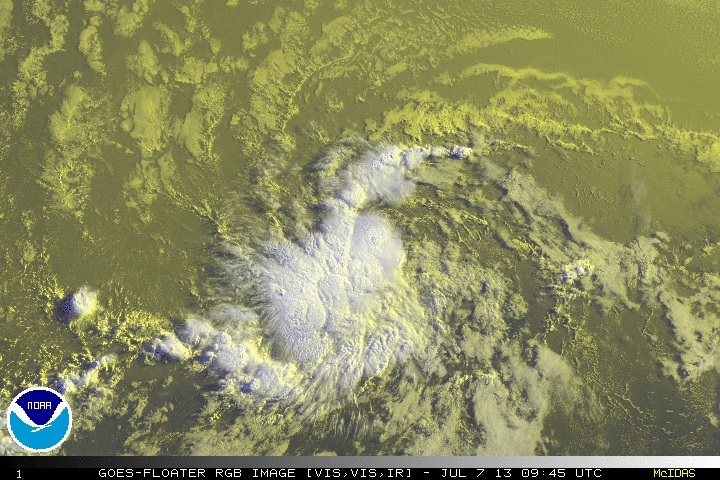
A small, but potent tropical disturbance is speeding westward at ~25 mph across the tropical Atlantic. This system, designated as "Invest 95-L" by the National Hurricane Center (NHC), demands our attention. All available data in the region indicate it possesses a well-defined counter-clockwise rotation, with a cluster of strong thunderstorms closely attached. When, or if, 95-L acquires a west wind on its south side (green arrow), NHC will go ahead and call it tropical depression. As of this morning, the wind flow around 95-L was not encircling the lowest pressures ... but it's close. Keep in mind, 95-L is believed to have 35 mph winds already. So it would only take another 4 mph to make it a tropical storm. From what I've seen, I would not be surprised if it gets there ... though many of the models are bearish on developing 95-L during its cross-Atlantic trek.
Perhaps one of the reasons why most models do not favor significant development is the close proximity of the dreaded Saharan Air Layer (a layer of dry and dusty air from the African deserts between about 5,000 and 20,000 feet in altitude that kills thunderstorms). If the SAL (shaded in red below) finds a trap door into 95-L, it could permanently injure the circulation. We'll see. NHC gives 95-L a 40% chance of developing in the next 2 days.
Greg Postel, Hurricane and Storm Specialist, The Weather Channel
Jul 7, 2013 12:07 pm ET
-Vigorous tropical disturbance racing westward across tropical Atlantic ... development possible
Tropical Atlantic
A small, but potent tropical disturbance is speeding westward at ~25 mph across the tropical Atlantic. This system, designated as "Invest 95-L" by the National Hurricane Center (NHC), demands our attention. All available data in the region indicate it possesses a well-defined counter-clockwise rotation, with a cluster of strong thunderstorms closely attached. When, or if, 95-L acquires a west wind on its south side (green arrow), NHC will go ahead and call it tropical depression. As of this morning, the wind flow around 95-L was not encircling the lowest pressures ... but it's close. Keep in mind, 95-L is believed to have 35 mph winds already. So it would only take another 4 mph to make it a tropical storm. From what I've seen, I would not be surprised if it gets there ... though many of the models are bearish on developing 95-L during its cross-Atlantic trek.
Perhaps one of the reasons why most models do not favor significant development is the close proximity of the dreaded Saharan Air Layer (a layer of dry and dusty air from the African deserts between about 5,000 and 20,000 feet in altitude that kills thunderstorms). If the SAL (shaded in red below) finds a trap door into 95-L, it could permanently injure the circulation. We'll see. NHC gives 95-L a 40% chance of developing in the next 2 days.
0 likes
-
Aric Dunn
- Category 5
- Posts: 21238
- Age: 43
- Joined: Sun Sep 19, 2004 9:58 pm
- Location: Ready for the Chase.
- Contact:
anyone else not getting the FSU site to update.. mine still stuck on yesterday 12z
0 likes
Note: If I make a post that is brief. Please refer back to previous posts for the analysis or reasoning. I do not re-write/qoute what my initial post said each time.
If there is nothing before... then just ask
Space & Atmospheric Physicist, Embry-Riddle Aeronautical University,
I believe the sky is falling...
If there is nothing before... then just ask
Space & Atmospheric Physicist, Embry-Riddle Aeronautical University,
I believe the sky is falling...
-
gatorcane

- S2K Supporter
- Posts: 23708
- Age: 48
- Joined: Sun Mar 13, 2005 3:54 pm
- Location: Boca Raton, FL
Seems to be doing quite well fending off the SAL. Latest Vis imagery suggests the SAL is more north and east of where 95L is currently from this time yesterday and is indeed heading toward an environment which is even more favorable (higher SSTs and low shear) and what the NHC has been suggesting...
0 likes
-
TheStormExpert
Re: Re:
Evil Jeremy wrote:CrazyC83 wrote:Chantal at 5 pm perhaps?
It wouldn't surprise me seeing how Stewart is on shift and he used the "At any time" line, which is normally saved for 80-90 percent TWOs.
Yeah and he also is mentioning the potential for TS Watches and Warnings for portions of the Lesser Antillies. So this means the likelihood of a TS is increasing.
0 likes

Re: ATL: INVEST 95L - Models
12Z CMC; 150hr

Last edited by N2FSU on Sun Jul 07, 2013 12:55 pm, edited 1 time in total.
0 likes
-
Gustywind
- Category 5
- Posts: 12334
- Joined: Mon Sep 03, 2007 7:29 am
- Location: Baie-Mahault, GUADELOUPE
000
AXNT20 KNHC 071747
TWDAT
TROPICAL WEATHER DISCUSSION
NWS NATIONAL HURRICANE CENTER MIAMI FL
205 PM EDT SUN JUL 07 2013
TROPICAL WEATHER DISCUSSION FOR NORTH AMERICA...CENTRAL
AMERICA...GULF OF MEXICO...CARIBBEAN SEA...NORTHERN SECTIONS OF
SOUTH AMERICA...AND ATLANTIC OCEAN TO THE AFRICAN COAST FROM THE
EQUATOR TO 32N. THE FOLLOWING INFORMATION IS BASED ON SATELLITE
IMAGERY...WEATHER OBSERVATIONS...RADAR...AND METEOROLOGICAL
ANALYSIS.
BASED ON 1200 UTC SURFACE ANALYSIS AND SATELLITE IMAGERY THROUGH
1715 UTC.
...SPECIAL FEATURES...
TROPICAL WAVE EXTENDS FROM A 1010 MB LOW CENTERED NEAR 09N41W TO
15N40W MOVING W AT 20-25 KT. WHILE MOST OF THE WAVE AXIS ITSELF
REMAINS EMBEDDED WITHIN SAHARAN DUST AND DOES NOT EXHIBIT ANY
CONVECTION...THE LOW CENTER LOCATED ON THE SOUTHERN EXTENT OF
THE WAVE AXIS REMAINS EMBEDDED WITHIN THE ITCZ AND EXHIBITS A
RELATIVELY SMALL AREAL COVERAGE CYCLONIC SPIN ON SATELLITE
IMAGERY THAT WAS CAPTURED ON AN EARLIER MORNING ASCAT PASS
AROUND 07/1250 UTC. SCATTERED MODERATE CONVECTION IS OCCURRING
FROM 06N-10N BETWEEN 42W-46W. THIS SYSTEM HAS A HIGH CHANCE OF
TROPICAL CYCLONE DEVELOPMENT WITHIN THE NEXT 48 HOURS.
0 likes

-
gatorcane
- S2K Supporter
- Posts: 23708
- Age: 48
- Joined: Sun Mar 13, 2005 3:54 pm
- Location: Boca Raton, FL
Looping the latest 12Z GFS run shows Bermuda High building westward over the mid-atlantic states by early next week...
http://www.meteo.psu.edu/~fxg1/GFSTROPA ... sloop.html
and another Cape Verde system on the way in the MDR...
http://www.meteo.psu.edu/~fxg1/GFSTROPA ... sloop.html
and another Cape Verde system on the way in the MDR...
0 likes
-
TheStormExpert
Re:
gatorcane wrote:Seems to be doing quite well fending off the SAL. Latest Vis imagery suggests the SAL is more north and east of where 95L is currently from this time yesterday and is indeed heading toward an environment which is even more favorable (higher SSTs and low shear) and what the NHC has been suggesting...
The NHC has been suggesting that conditions would continue to become more favorable for the past day. But as of the 2pm TWO they now are saying conditions are conducive for development, as opposed to before when they were saying conditions are conducive for some development.
0 likes
-
Evil Jeremy
- S2K Supporter
- Posts: 5463
- Age: 32
- Joined: Mon Apr 10, 2006 2:10 pm
- Location: Los Angeles, CA
Re: ATL: INVEST 95L - Models
ECMWF rolling, here's 24 hrs out:

Last edited by Evil Jeremy on Sun Jul 07, 2013 1:08 pm, edited 1 time in total.
0 likes
Frances 04 / Jeanne 04 / Katrina 05 / Wilma 05 / Fay 08 / Debby 12 / Andrea 13 / Colin 16 / Hermine 16 / Matthew 16 / Irma 17
Who is online
Users browsing this forum: No registered users and 46 guests