
ATL: CHANTAL - Post-Tropical
Moderator: S2k Moderators
-
Rgv20

- S2K Supporter

- Posts: 2466
- Age: 39
- Joined: Wed Jan 05, 2011 5:42 pm
- Location: Edinburg/McAllen Tx
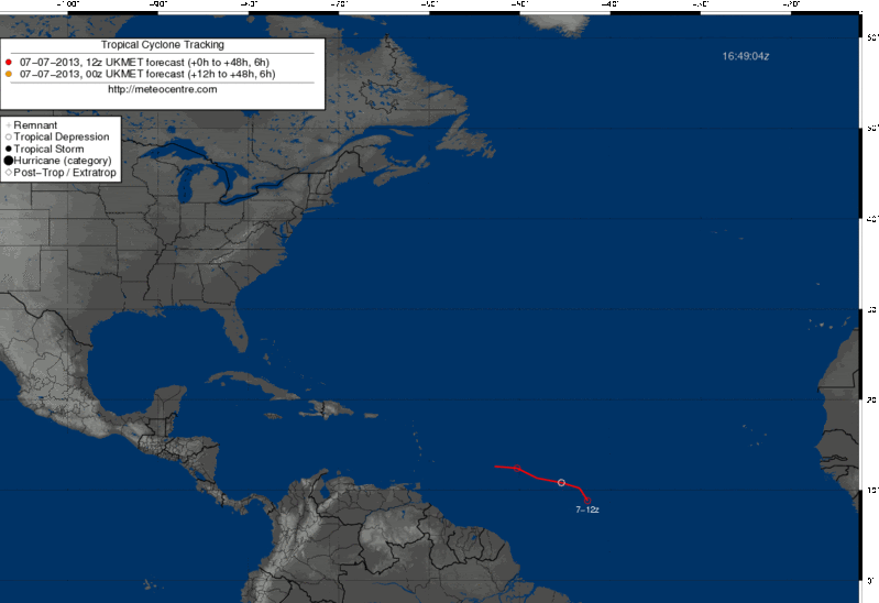
12zUKMET develops 95L to a TD then kills it off after 12hours..
0 likes
The following post is NOT an official forecast and should not be used as such. It is just the opinion of the poster and may or may not be backed by sound meteorological data. It is NOT endorsed by any professional institution including storm2k.org For Official Information please refer to the NHC and NWS products.
-
Gustywind

- Category 5

- Posts: 12334
- Joined: Mon Sep 03, 2007 7:29 am
- Location: Baie-Mahault, GUADELOUPE
Here is the full article of Dr Jeff Masters.
95L Near Tropical Depression Status, Headed Towards Lesser Antilles
Posted by: Dr. Jeff Masters, 16:39 GMT le 07 juillet 2013 +16
 http://www.wunderground.com/blog/JeffMa ... rynum=2455
A strong and unusually well-organized tropical wave for so early in the season (95L) is speeding westwards at 20 - 25 mph over the Central Atlantic. At noon EDT on Sunday, 95L was near 9.5°N, 43°W, about 1200 miles east of the Lesser Antilles Islands. Satellite loops show that 95L has a well-developed surface circulation center that is exposed to view, with a modest clump of heavy thunderstorms on the south side of the center. The system has several well-developed low-level spiral bands, but is fighting dry air associated with the Saharan Air Layer (SAL). July African tropical waves typically have considerable trouble getting organized in the very dry air of the SAL, and the only factor keeping 95L from currently being classified as a tropical depression is the relative lack of persistent heavy thunderstorm activity near the center of the storm due to dry air. This dry air is readily apparent on water vapor satellite loops. However, the latest SAL analysis (Figure 2) from the University of Wisconsin's SSEC group shows that 95L has moistened the air around it sufficiently to keep the SAL somewhat at bay. An 11:12 am EDT pass by the ASCAT satellite showed top winds of 45 mph on the west side of 95L's center of circulation. ASCAT did not show a closed circulation at the time. Wind shear is light to moderate, 5 - 15 knots, and ocean temperatures are warm, 27.5 - 28°C. An Air Force hurricane hunter aircraft is on call to investigate 95L on Monday afternoon.
Forecast for 95L
The 8 am EDT Sunday forecast from the SHIPS model predicted that 95L would experience low to moderate shear through Tuesday morning as it headed west to west-northwest at 20 - 25 mph. The disturbance should arrive in the Lesser Antilles Islands on Tuesday, and affect the Dominican Republic by Wednesday night. A band a strong upper-level winds associated with the subtropical jet stream is expected to be over the northern islands this week, and as soon as 95L penetrates as far north as 15°N latitude, it will encounter high wind shear of 20 - 30 knots. But if 95L stays farther to the south, wind shear should be lower, giving the storm a better chance of development. None of the reliable forecast models predict that 95L will develop. In their 8 am EDT July 7 Tropical Weather Outlook, NHC gave the disturbance a 40% chance of developing into a tropical depression or tropical storm by Tuesday. I put these odds higher, at 70%. Climatology argues against 95L becoming a tropical depression east of the Lesser Antilles Islands; there have been only 20 July tropical depressions that have formed east of the Lesser Antilles since 1851, an average of one tropical cyclone every eight years.
95L Near Tropical Depression Status, Headed Towards Lesser Antilles
Posted by: Dr. Jeff Masters, 16:39 GMT le 07 juillet 2013 +16
A strong and unusually well-organized tropical wave for so early in the season (95L) is speeding westwards at 20 - 25 mph over the Central Atlantic. At noon EDT on Sunday, 95L was near 9.5°N, 43°W, about 1200 miles east of the Lesser Antilles Islands. Satellite loops show that 95L has a well-developed surface circulation center that is exposed to view, with a modest clump of heavy thunderstorms on the south side of the center. The system has several well-developed low-level spiral bands, but is fighting dry air associated with the Saharan Air Layer (SAL). July African tropical waves typically have considerable trouble getting organized in the very dry air of the SAL, and the only factor keeping 95L from currently being classified as a tropical depression is the relative lack of persistent heavy thunderstorm activity near the center of the storm due to dry air. This dry air is readily apparent on water vapor satellite loops. However, the latest SAL analysis (Figure 2) from the University of Wisconsin's SSEC group shows that 95L has moistened the air around it sufficiently to keep the SAL somewhat at bay. An 11:12 am EDT pass by the ASCAT satellite showed top winds of 45 mph on the west side of 95L's center of circulation. ASCAT did not show a closed circulation at the time. Wind shear is light to moderate, 5 - 15 knots, and ocean temperatures are warm, 27.5 - 28°C. An Air Force hurricane hunter aircraft is on call to investigate 95L on Monday afternoon.
Forecast for 95L
The 8 am EDT Sunday forecast from the SHIPS model predicted that 95L would experience low to moderate shear through Tuesday morning as it headed west to west-northwest at 20 - 25 mph. The disturbance should arrive in the Lesser Antilles Islands on Tuesday, and affect the Dominican Republic by Wednesday night. A band a strong upper-level winds associated with the subtropical jet stream is expected to be over the northern islands this week, and as soon as 95L penetrates as far north as 15°N latitude, it will encounter high wind shear of 20 - 30 knots. But if 95L stays farther to the south, wind shear should be lower, giving the storm a better chance of development. None of the reliable forecast models predict that 95L will develop. In their 8 am EDT July 7 Tropical Weather Outlook, NHC gave the disturbance a 40% chance of developing into a tropical depression or tropical storm by Tuesday. I put these odds higher, at 70%. Climatology argues against 95L becoming a tropical depression east of the Lesser Antilles Islands; there have been only 20 July tropical depressions that have formed east of the Lesser Antilles since 1851, an average of one tropical cyclone every eight years.
0 likes
-
Evil Jeremy

- S2K Supporter
- Posts: 5463
- Age: 32
- Joined: Mon Apr 10, 2006 2:10 pm
- Location: Los Angeles, CA
Re: ATL: INVEST 95L - Discussion
torrea40 wrote:blp wrote:Dr Masters going with 70%.
http://www.wunderground.com/blog/JeffMasters/show.htmlIn their 8 am EDT July 7 Tropical Weather Outlook, NHC gave the disturbance a 40% chance of developing into a tropical depression or tropical storm by Tuesday. I put these odds higher, at 70%. Climatology argues against 95L becoming a tropical depression east of the Lesser Antilles Islands; there have been only 20 July tropical depressions that have formed east of the Lesser Antilles since 1851, an average of one tropical cyclone every eight years.
70% today.???????????
I agree with the 70%, although I think the NHC will only go to 50% at 2pm. This has a closed LLC, and should be a TD by the time recon gets into the system tomorrow, if it isn't one already.
Also, welcome to the forum!
Last edited by Evil Jeremy on Sun Jul 07, 2013 12:11 pm, edited 1 time in total.
0 likes
Frances 04 / Jeanne 04 / Katrina 05 / Wilma 05 / Fay 08 / Debby 12 / Andrea 13 / Colin 16 / Hermine 16 / Matthew 16 / Irma 17


Re: Re:
Aric Dunn wrote:Alyono wrote:Aric Dunn wrote:you can clearly see the circ briefly before it got covered back up. typical NHC they will wait till its threatens.
what? There is clearly no earth relative circ. Storm relative does not count
Oh come on. You know the difference as well as me and although there is "no real way to comfirm" without obs this is a classic TD/Ts TC being affected by dry air and sal.
Actually, there is. The satellite data!
0 likes
-
Stormlover2012
- Category 1

- Posts: 262
- Joined: Sat Jun 23, 2012 11:03 am
Re: ATL: INVEST 95L - Models
Until euro develops something then ill be interested!!! Best model!
0 likes
Re: Re:
Incident_MET wrote:Alyono wrote:Aric Dunn wrote:you can clearly see the circ briefly before it got covered back up. typical NHC they will wait till its threatens.
what? There is clearly no earth relative circ. Storm relative does not count
Alyono: What does "geostationary imagery" mean in your definition ??
Geostationary imagery is often misleading in these developing systems. I remember Claudette in 2003 looking as if it had a circ for many days on geostationary imagery. Yet, the QUIKSCAT and recon never indicated a circ until it reached the EC
0 likes
-
Aric Dunn
- Category 5
- Posts: 21238
- Age: 43
- Joined: Sun Sep 19, 2004 9:58 pm
- Location: Ready for the Chase.
- Contact:
Re: Re:
Alyono wrote:Aric Dunn wrote:Alyono wrote:
what? There is clearly no earth relative circ. Storm relative does not count
Oh come on. You know the difference as well as me and although there is "no real way to comfirm" without obs this is a classic TD/Ts TC being affected by dry air and sal.
Actually, there is. The satellite data!
really lol.. you know i was referring to surface obs or recon....
0 likes
Note: If I make a post that is brief. Please refer back to previous posts for the analysis or reasoning. I do not re-write/qoute what my initial post said each time.
If there is nothing before... then just ask
Space & Atmospheric Physicist, Embry-Riddle Aeronautical University,
I believe the sky is falling...
If there is nothing before... then just ask
Space & Atmospheric Physicist, Embry-Riddle Aeronautical University,
I believe the sky is falling...
-
Gustywind
- Category 5
- Posts: 12334
- Joined: Mon Sep 03, 2007 7:29 am
- Location: Baie-Mahault, GUADELOUPE
Tropical Atlantic Trying to Come Alive
Kristina Pydynowski
By Kristina Pydynowski, Senior Meteorologist
July 07, 2013; 12:26 PM
http://www.accuweather.com/en/weather-n ... o/15010525
The Atlantic Basin has been void of an organized tropical depression or storm since mid-June. That could change this week.
The AccuWeather.com Hurricane Center is keeping a close eye on a vigorous tropical wave located roughly in between Africa and the Windward Islands.
The window is open for the wave to organize into a tropical depression as it tracks toward, then across the northern Windward and southern Leeward islands through Tuesday.
Only the fast forward motion of the wave is working against its ability to strengthen. If the wave can overcome this and become a tropical depression, it should then continue to intensify into a tropical storm.
The next tropical storm in the Atlantic Basin would acquire the name "Chantal."
Nearly 2.5 weeks have passed since a tropical storm roamed the Atlantic Basin, when Tropical Storm Barry crossed from the northwestern Caribbean to the southwestern Gulf of Mexico.
The threat for flooding in low-lying and poor drainage areas will accompany the wave through the Windward and Leeward islands on Tuesday regardless of whether it is a tropical depression or storm.
The potential for winds causing tree and minor structural damage, as well as power outages, will increase as the wave intensifies.
The window for possible strengthening should close at midweek as the wave encounters stronger wind shear (disruptive winds above the surface). That window will slam shut if the wave also tracks close to or over the mountainous islands of Puerto Rico and Hispaniola.
Even though the mountainous terrain of Puerto Rico and Hispaniola should deter the wave from strengthening, these islands may still be faced with the danger of flooding rain and mudslides at midweek.
Later in the week, it is possible that the wave enhances the shower and thunderstorm activity across the Florida Peninsula.
Kristina Pydynowski
By Kristina Pydynowski, Senior Meteorologist
July 07, 2013; 12:26 PM
The Atlantic Basin has been void of an organized tropical depression or storm since mid-June. That could change this week.
The AccuWeather.com Hurricane Center is keeping a close eye on a vigorous tropical wave located roughly in between Africa and the Windward Islands.
The window is open for the wave to organize into a tropical depression as it tracks toward, then across the northern Windward and southern Leeward islands through Tuesday.
Only the fast forward motion of the wave is working against its ability to strengthen. If the wave can overcome this and become a tropical depression, it should then continue to intensify into a tropical storm.
The next tropical storm in the Atlantic Basin would acquire the name "Chantal."
Nearly 2.5 weeks have passed since a tropical storm roamed the Atlantic Basin, when Tropical Storm Barry crossed from the northwestern Caribbean to the southwestern Gulf of Mexico.
The threat for flooding in low-lying and poor drainage areas will accompany the wave through the Windward and Leeward islands on Tuesday regardless of whether it is a tropical depression or storm.
The potential for winds causing tree and minor structural damage, as well as power outages, will increase as the wave intensifies.
The window for possible strengthening should close at midweek as the wave encounters stronger wind shear (disruptive winds above the surface). That window will slam shut if the wave also tracks close to or over the mountainous islands of Puerto Rico and Hispaniola.
Even though the mountainous terrain of Puerto Rico and Hispaniola should deter the wave from strengthening, these islands may still be faced with the danger of flooding rain and mudslides at midweek.
Later in the week, it is possible that the wave enhances the shower and thunderstorm activity across the Florida Peninsula.
0 likes
-
Aric Dunn
- Category 5
- Posts: 21238
- Age: 43
- Joined: Sun Sep 19, 2004 9:58 pm
- Location: Ready for the Chase.
- Contact:
Re: Re:
Alyono wrote:Incident_MET wrote:Alyono wrote:what? There is clearly no earth relative circ. Storm relative does not count
Alyono: What does "geostationary imagery" mean in your definition ??
Geostationary imagery is often misleading in these developing systems. I remember Claudette in 2003 looking as if it had a circ for many days on geostationary imagery. Yet, the QUIKSCAT and recon never indicated a circ until it reached the EC
true and the opposite is true. there have been cases (especially in cases with a small wind field) where scat showed no circ but recon found one.
0 likes
Note: If I make a post that is brief. Please refer back to previous posts for the analysis or reasoning. I do not re-write/qoute what my initial post said each time.
If there is nothing before... then just ask
Space & Atmospheric Physicist, Embry-Riddle Aeronautical University,
I believe the sky is falling...
If there is nothing before... then just ask
Space & Atmospheric Physicist, Embry-Riddle Aeronautical University,
I believe the sky is falling...

Re: ATL: INVEST 95L - Discussion
This site is really good for tracking systems http://tropic.ssec.wisc.edu/
and for 95L go here specifically http://tropic.ssec.wisc.edu/real-time/storm.newtest.php?&basin=atlantic&sname=95L&invest=YES&zoom=4&img=1&vars=11111000000000000000000&loop=0
tap "Vis(1km)" at the top then "animate" on the left.
lots of other cool overlays too.
and for 95L go here specifically http://tropic.ssec.wisc.edu/real-time/storm.newtest.php?&basin=atlantic&sname=95L&invest=YES&zoom=4&img=1&vars=11111000000000000000000&loop=0
tap "Vis(1km)" at the top then "animate" on the left.
lots of other cool overlays too.
0 likes
-
TheStormExpert
Re: ATL: INVEST 95L - Discussion
SFLcane wrote:Needs to put the breaks on a bit
This has been the problem with a handful of tropical systems the past 2 seasons. One example that comes to my mind immediately is TS Emily from 2011 which really struggled due to the center outrunning the convection and becoming exposed.
0 likes
-
torrea40
-
Hurricaneman

- Category 5
- Posts: 7404
- Age: 45
- Joined: Tue Aug 31, 2004 3:24 pm
- Location: central florida
Re: ATL: INVEST 95L - Discussion
TheStormExpert wrote:SFLcane wrote:Needs to put the breaks on a bit
This has been the problem with a handful of tropical systems the past 2 seasons. One example that comes to my mind immediately is TS Emily from 2011 which really struggled due to the center outrunning the convection and becoming exposed.
This one seems to be doing the same thing, self induced shear
0 likes
-
Aric Dunn
- Category 5
- Posts: 21238
- Age: 43
- Joined: Sun Sep 19, 2004 9:58 pm
- Location: Ready for the Chase.
- Contact:
Re: ATL: INVEST 95L - Discussion
torrea40 wrote:The system is starting to divorce from the ITCZ....
lol I love the "divorce" terminology..
0 likes
Note: If I make a post that is brief. Please refer back to previous posts for the analysis or reasoning. I do not re-write/qoute what my initial post said each time.
If there is nothing before... then just ask
Space & Atmospheric Physicist, Embry-Riddle Aeronautical University,
I believe the sky is falling...
If there is nothing before... then just ask
Space & Atmospheric Physicist, Embry-Riddle Aeronautical University,
I believe the sky is falling...
-
Evil Jeremy
- S2K Supporter
- Posts: 5463
- Age: 32
- Joined: Mon Apr 10, 2006 2:10 pm
- Location: Los Angeles, CA
Code Red, 60%
000
ABNT20 KNHC 071720
TWOAT
TROPICAL WEATHER OUTLOOK
NWS NATIONAL HURRICANE CENTER MIAMI FL
200 PM EDT SUN JUL 7 2013
FOR THE NORTH ATLANTIC...CARIBBEAN SEA AND THE GULF OF MEXICO...
A STRONG TROPICAL WAVE LOCATED ABOUT 1150 MILES EAST-SOUTHEAST OF
THE WINDWARD ISLANDS IS MOVING WESTWARD AT 25 MPH. SHOWER AND
THUNDERSTORM ACTIVITY CONTINUES TO SHOW SIGNS OF ORGANIZATION...
AND RECENT SATELLITE WIND DATA INDICATE THAT A CLOSED SURFACE
CIRCULATION MAY BE FORMING. ENVIRONMENTAL CONDITIONS ARE CONDUCIVE
FOR FURTHER DEVELOPMENT OF THIS DISTURBANCE...AND A TROPICAL
DEPRESSION OR A TROPICAL STORM COULD FORM AT ANY TIME...WHICH WOULD
REQUIRE A TROPICAL STORM WATCH OR WARNING FOR PORTIONS OF THE
LESSER ANTILLES. THIS SYSTEM HAS A HIGH CHANCE...60 PERCENT...OF
BECOMING A TROPICAL CYCLONE DURING THE NEXT 48 HOURS.
ELSEWHERE...TROPICAL CYCLONE FORMATION IS NOT EXPECTED DURING THE
NEXT 48 HOURS.
$$
FORECASTER STEWART
Last edited by Evil Jeremy on Sun Jul 07, 2013 12:28 pm, edited 2 times in total.
0 likes
Frances 04 / Jeanne 04 / Katrina 05 / Wilma 05 / Fay 08 / Debby 12 / Andrea 13 / Colin 16 / Hermine 16 / Matthew 16 / Irma 17
-
Aric Dunn
- Category 5
- Posts: 21238
- Age: 43
- Joined: Sun Sep 19, 2004 9:58 pm
- Location: Ready for the Chase.
- Contact:
Re:
Evil Jeremy wrote:Code Red, 60%
000
ABNT20 KNHC 071720
TWOAT
TROPICAL WEATHER OUTLOOK
NWS NATIONAL HURRICANE CENTER MIAMI FL
200 PM EDT SUN JUL 7 2013
FOR THE NORTH ATLANTIC...CARIBBEAN SEA AND THE GULF OF MEXICO...
A STRONG TROPICAL WAVE LOCATED ABOUT 1150 MILES EAST-SOUTHEAST OF
THE WINDWARD ISLANDS IS MOVING WESTWARD AT 25 MPH. SHOWER AND
THUNDERSTORM ACTIVITY CONTINUES TO SHOW SIGNS OF ORGANIZATION...
AND RECENT SATELLITE WIND DATA INDICATE THAT A CLOSED SURFACE
CIRCULATION MAY BE FORMING. ENVIRONMENTAL CONDITIONS ARE CONDUCIVE
FOR FURTHER DEVELOPMENT OF THIS DISTURBANCE...AND A TROPICAL
DEPRESSION OR A TROPICAL STORM COULD FORM AT ANY TIME...WHICH WOULD
REQUIRE A TROPICAL STORM WATCH OR WARNING FOR PORTIONS OF THE
LESSER ANTILLES. THIS SYSTEM HAS A HIGH CHANCE...60 PERCENT...OF
BECOMING A TROPICAL CYCLONE DURING THE NEXT 48 HOURS.
ELSEWHERE...TROPICAL CYCLONE FORMATION IS NOT EXPECTED DURING THE
NEXT 48 HOURS.
$$
FORECASTER STEWART
About time and Im glad they jumped on the band wagon.. I do like stewart...
0 likes
Note: If I make a post that is brief. Please refer back to previous posts for the analysis or reasoning. I do not re-write/qoute what my initial post said each time.
If there is nothing before... then just ask
Space & Atmospheric Physicist, Embry-Riddle Aeronautical University,
I believe the sky is falling...
If there is nothing before... then just ask
Space & Atmospheric Physicist, Embry-Riddle Aeronautical University,
I believe the sky is falling...
Who is online
Users browsing this forum: No registered users and 75 guests