ATL: CHANTAL - Post-Tropical
Moderator: S2k Moderators
Re: ATL: INVEST 95L - Models
The GFS is keeping it in the Caribbean, and rides it along the northern islands, never really amounting to much, but the globals still don't seem to have a good grasp on the system yet.
0 likes
-
cycloneye

- Admin

- Posts: 149730
- Age: 69
- Joined: Thu Oct 10, 2002 10:54 am
- Location: San Juan, Puerto Rico
Re: ATL: INVEST 95L - Discussion
Aric, post those great visible animations that you have. 
0 likes
Visit the Caribbean-Central America Weather Thread where you can find at first post web cams,radars
and observations from Caribbean basin members Click Here
and observations from Caribbean basin members Click Here
-
floridasun78
- Category 5

- Posts: 3755
- Joined: Sun May 17, 2009 10:16 pm
- Location: miami fl
Re:
Hurricaneman wrote:Does anyone think this will become Chantal before the islands?
no one know only nhc but it do look like low east of storms so speed could be issue
0 likes
-
Aric Dunn
- Category 5
- Posts: 21238
- Age: 43
- Joined: Sun Sep 19, 2004 9:58 pm
- Location: Ready for the Chase.
- Contact:
its pretty straight forward... it might be small system... but its a tc...
0 likes
Note: If I make a post that is brief. Please refer back to previous posts for the analysis or reasoning. I do not re-write/qoute what my initial post said each time.
If there is nothing before... then just ask
Space & Atmospheric Physicist, Embry-Riddle Aeronautical University,
I believe the sky is falling...
If there is nothing before... then just ask
Space & Atmospheric Physicist, Embry-Riddle Aeronautical University,
I believe the sky is falling...


-
floridasun78
- Category 5
- Posts: 3755
- Joined: Sun May 17, 2009 10:16 pm
- Location: miami fl
-
Hurricaneman

- Category 5
- Posts: 7404
- Age: 45
- Joined: Tue Aug 31, 2004 3:24 pm
- Location: central florida
Re: ATL: INVEST 95L - Discussion
SFLcane wrote:Needs to put the breaks on a bit
Probably won't do that until its near the larger islands if the models and forecast are right, but storms can make it like Charley did in 2004, had similar trade wind conditions but a more moist environment this one doesn't have
0 likes
-
JonathanBelles
- Professional-Met

- Posts: 11430
- Age: 35
- Joined: Sat Dec 24, 2005 9:00 pm
- Location: School: Florida State University (Tallahassee, FL) Home: St. Petersburg, Florida
- Contact:

-
Aric Dunn
- Category 5
- Posts: 21238
- Age: 43
- Joined: Sun Sep 19, 2004 9:58 pm
- Location: Ready for the Chase.
- Contact:
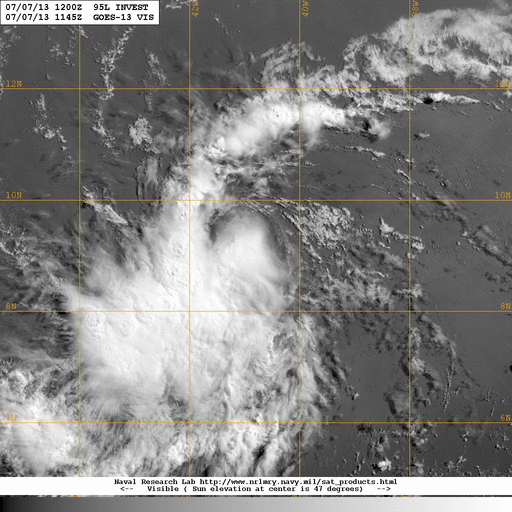
you can clearly see the circ briefly before it got covered back up. typical NHC they will wait till its threatens.
0 likes
Note: If I make a post that is brief. Please refer back to previous posts for the analysis or reasoning. I do not re-write/qoute what my initial post said each time.
If there is nothing before... then just ask
Space & Atmospheric Physicist, Embry-Riddle Aeronautical University,
I believe the sky is falling...
If there is nothing before... then just ask
Space & Atmospheric Physicist, Embry-Riddle Aeronautical University,
I believe the sky is falling...

Re:
Aric Dunn wrote:you can clearly see the circ briefly before it got covered back up. typical NHC they will wait till its threatens.
what? There is clearly no earth relative circ. Storm relative does not count
0 likes
-
Hurricane Andrew

- S2K Supporter

- Posts: 1891
- Age: 27
- Joined: Sun May 23, 2010 2:53 pm
- Location: KS
The posts in this forum are NOT official forecast and should not be used as such. They are just the opinion of the poster and may or may not be backed by sound meteorological data. They are NOT endorsed by any professional institution or storm2k.org. For official information, please refer to the NHC and NWS products.
Storm: 95L
Forecast: 3
Chance of Development
48 Hours: 40%
72 Hours: 50%
120 Hours: 60%
Storm: 95L
Forecast: 3
Chance of Development
48 Hours: 40%
72 Hours: 50%
120 Hours: 60%
0 likes
The Enthusiast
NREMT-AEMT, WX nerd
Irene '11, Sandy '12, Irma '17 (SAR)
"Hard to think we were born to live this way..." -Wage War
-
Aric Dunn
- Category 5
- Posts: 21238
- Age: 43
- Joined: Sun Sep 19, 2004 9:58 pm
- Location: Ready for the Chase.
- Contact:
Re: Re:
Alyono wrote:Aric Dunn wrote:you can clearly see the circ briefly before it got covered back up. typical NHC they will wait till its threatens.
what? There is clearly no earth relative circ. Storm relative does not count
Oh come on. You know the difference as well as me and although there is "no real way to comfirm" without obs this is a classic TD/Ts TC being affected by dry air and sal.
0 likes
Note: If I make a post that is brief. Please refer back to previous posts for the analysis or reasoning. I do not re-write/qoute what my initial post said each time.
If there is nothing before... then just ask
Space & Atmospheric Physicist, Embry-Riddle Aeronautical University,
I believe the sky is falling...
If there is nothing before... then just ask
Space & Atmospheric Physicist, Embry-Riddle Aeronautical University,
I believe the sky is falling...

Re: ATL: INVEST 95L - Discussion
Dr Masters going with 70%.
http://www.wunderground.com/blog/JeffMasters/show.html
http://www.wunderground.com/blog/JeffMasters/show.html
In their 8 am EDT July 7 Tropical Weather Outlook, NHC gave the disturbance a 40% chance of developing into a tropical depression or tropical storm by Tuesday. I put these odds higher, at 70%. Climatology argues against 95L becoming a tropical depression east of the Lesser Antilles Islands; there have been only 20 July tropical depressions that have formed east of the Lesser Antilles since 1851, an average of one tropical cyclone every eight years.
0 likes
The following post is NOT an official forecast and should not be used as such. It is just the opinion of the poster and may or may not be backed by sound meteorological data. It is NOT endorsed by any professional institution including storm2k.org For Official Information please refer to the NHC and NWS products.
-
Incident_MET

- Professional-Met
- Posts: 63
- Joined: Tue Mar 28, 2006 10:22 pm
- Location: Floridana Beach, FL
Re: Re:
Alyono wrote:Aric Dunn wrote:you can clearly see the circ briefly before it got covered back up. typical NHC they will wait till its threatens.
what? There is clearly no earth relative circ. Storm relative does not count
Alyono: What does "geostationary imagery" mean in your definition ??
0 likes
-
Dean4Storms
- S2K Supporter
- Posts: 6358
- Age: 63
- Joined: Sun Aug 31, 2003 1:01 pm
- Location: Miramar Bch. FL
12z GFS....... Does not do much with 95L but man the pattern toward Florida! Whoa!
http://www.tropicaltidbits.com/analysis ... _watl.html
http://www.tropicaltidbits.com/analysis ... _watl.html
0 likes
-
Dean4Storms
- S2K Supporter
- Posts: 6358
- Age: 63
- Joined: Sun Aug 31, 2003 1:01 pm
- Location: Miramar Bch. FL
12Z GEM.....Still bullish toward SC Coast and develops another TC in the eastern Gulf.
http://www.tropicaltidbits.com/analysis ... _watl.html
http://www.tropicaltidbits.com/analysis ... _watl.html
0 likes
-
Dean4Storms
- S2K Supporter
- Posts: 6358
- Age: 63
- Joined: Sun Aug 31, 2003 1:01 pm
- Location: Miramar Bch. FL
-
torrea40
Re: ATL: INVEST 95L - Discussion
blp wrote:Dr Masters going with 70%.
http://www.wunderground.com/blog/JeffMasters/show.htmlIn their 8 am EDT July 7 Tropical Weather Outlook, NHC gave the disturbance a 40% chance of developing into a tropical depression or tropical storm by Tuesday. I put these odds higher, at 70%. Climatology argues against 95L becoming a tropical depression east of the Lesser Antilles Islands; there have been only 20 July tropical depressions that have formed east of the Lesser Antilles since 1851, an average of one tropical cyclone every eight years.
70% today.???????????
0 likes
Who is online
Users browsing this forum: No registered users and 31 guests