

ATL: CHANTAL - Post-Tropical
Moderator: S2k Moderators
-
cycloneye

- Admin

- Posts: 149706
- Age: 69
- Joined: Thu Oct 10, 2002 10:54 am
- Location: San Juan, Puerto Rico
Re: ATL: INVEST 95L - Models
GFS ensembles.

0 likes
Visit the Caribbean-Central America Weather Thread where you can find at first post web cams,radars
and observations from Caribbean basin members Click Here
and observations from Caribbean basin members Click Here
-
Gustywind

- Category 5

- Posts: 12334
- Joined: Mon Sep 03, 2007 7:29 am
- Location: Baie-Mahault, GUADELOUPE
Re: ATL: INVEST 95L - Models
Leewards trip in store ?! Let's wait and see again to have a better idea but seems that the Eastern Carib is really in that path if something happens ( should it verifies first!).
0 likes
-
Gustywind
- Category 5
- Posts: 12334
- Joined: Mon Sep 03, 2007 7:29 am
- Location: Baie-Mahault, GUADELOUPE
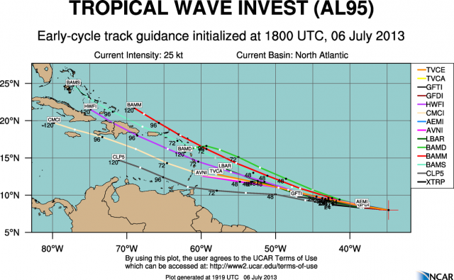
1845z Models guidance.
TROPICAL CYCLONE GUIDANCE MESSAGE
NWS NATIONAL HURRICANE CENTER MIAMI FL
1845 UTC SAT JUL 6 2013
DISCLAIMER...NUMERICAL MODELS ARE SUBJECT TO LARGE ERRORS.
PLEASE REFER TO NHC OFFICIAL FORECASTS FOR TROPICAL CYCLONE
AND SUBTROPICAL CYCLONE INFORMATION.
ATLANTIC OBJECTIVE AIDS FOR
DISTURBANCE INVEST (AL952013) 20130706 1800 UTC
...00 HRS... ...12 HRS... ...24 HRS. .. ...36 HRS...
130706 1800 130707 0600 130707 1800 130708 0600
LAT LON LAT LON LAT LON LAT LON
BAMS 8.0N 34.8W 8.5N 38.5W 9.6N 42.9W 11.1N 47.8W
BAMD 8.0N 34.8W 8.5N 38.0W 9.4N 41.4W 10.7N 45.0W
BAMM 8.0N 34.8W 8.5N 38.4W 9.6N 42.4W 10.9N 46.7W
LBAR 8.0N 34.8W 8.4N 38.7W 9.2N 43.1W 10.4N 47.8W
...48 HRS... ...72 HRS... ...96 HRS. .. ..120 HRS...
130708 1800 130709 1800 130710 1800 130711 1800
LAT LON LAT LON LAT LON LAT LON
BAMS 13.0N 53.0W 17.3N 63.2W 21.2N 71.9W 24.7N 77.2W
BAMD 12.2N 48.6W 15.1N 55.0W 16.6N 59.3W 15.8N 62.2W
BAMM 12.6N 51.1W 16.2N 59.3W 19.7N 65.7W 21.7N 69.0W
LBAR 11.9N 52.4W .0N .0W .0N .0W .0N .0W
...INITIAL CONDITIONS...
LATCUR = 8.0N LONCUR = 34.8W DIRCUR = 275DEG SPDCUR = 20KT
LATM12 = 7.7N LONM12 = 31.0W DIRM12 = 272DEG SPDM12 = 16KT
LATM24 = 7.6N LONM24 = 27.8W
WNDCUR = 25KT RMAXWD = 60NM WNDM12 = 25KT
CENPRS = 1009MB OUTPRS = 1012MB OUTRAD = 140NM SDEPTH = M
RD34NE = 0NM RD34SE = 0NM RD34SW = 0NM RD34NW = 0NM
$$
NNNN
0 likes
-
cycloneye
- Admin
- Posts: 149706
- Age: 69
- Joined: Thu Oct 10, 2002 10:54 am
- Location: San Juan, Puerto Rico
Re: ATL: INVEST 95L - Discussion
ATCF updated the 18z Best Track.
AL, 95, 2013070618, , BEST, 0, 80N, 348W, 25, 1009, WV
ftp://ftp.nhc.noaa.gov/atcf/tcweb/inves ... 013.invest
AL, 95, 2013070618, , BEST, 0, 80N, 348W, 25, 1009, WV
ftp://ftp.nhc.noaa.gov/atcf/tcweb/inves ... 013.invest
0 likes
Visit the Caribbean-Central America Weather Thread where you can find at first post web cams,radars
and observations from Caribbean basin members Click Here
and observations from Caribbean basin members Click Here
-
wxman57

- Moderator-Pro Met

- Posts: 23175
- Age: 68
- Joined: Sat Jun 21, 2003 8:06 pm
- Location: Houston, TX (southwest)
Re: ATL: INVEST 95L - Discussion
Certainly looks more impressive than 94L. All models indicate significant shear in its path as it approaches the eastern Caribbean Monday night (beyond 48 hrs). After that, conditions may improve beyond 120 hrs as it reaches 70-75W.
0 likes
-
jaguarjace

- Category 4

- Posts: 975
- Age: 31
- Joined: Sat Jun 11, 2011 7:38 am
- Location: Khon Kaen, Thailand
Re: ATL: INVEST 95L - Discussion
No floater but here's an alternative loop

0 likes
Owner of the Tropical Archive YouTube channel
Web Developer at Force Thirteen
Twitter/X : @force13_support
Web Developer at Force Thirteen
Twitter/X : @force13_support
-
hurricaneCW
- Category 5
- Posts: 1799
- Joined: Wed Mar 03, 2010 6:20 am
- Location: Toms River, NJ
Re: ATL: INVEST 95L - Discussion
This is another one of those disturbances that would have likely been a TD by now if it was say in the Caribbean or GOM. The curvature and obvious banding signatures are very impressive for a wave so far east and prior to the Cape Verde season.
If they name much worse looking disturbances TDs or storms that threaten land, why not be fair and do the same for those much further away who may often look far more impressive.
If they name much worse looking disturbances TDs or storms that threaten land, why not be fair and do the same for those much further away who may often look far more impressive.
0 likes
-
CrazyC83
- Professional-Met

- Posts: 34316
- Joined: Tue Mar 07, 2006 11:57 pm
- Location: Deep South, for the first time!
Re: ATL: INVEST 95L - Discussion
hurricaneCW wrote:This is another one of those disturbances that would have likely been a TD by now if it was say in the Caribbean or GOM. The curvature and obvious banding signatures are very impressive for a wave so far east and prior to the Cape Verde season.
If they name much worse looking disturbances TDs or storms that threaten land, why not be fair and do the same for those much further away who may often look far more impressive.
There is no need for the NHC to be too aggressive that far out, since there are no warnings or watches necessary, and not until Monday or Tuesday at least probably. Of course I wish Recon could reach 35W but there is no plane with enough gas to get that far out except perhaps the Global Hawk, and why waste a mission this early for a developing system?
I'd personally say this is a tropical storm based on microwave + OSCAT earlier...
0 likes
-
ozonepete
- Professional-Met
- Posts: 4743
- Joined: Mon Sep 07, 2009 3:23 pm
- Location: From Ozone Park, NYC / Now in Brooklyn, NY
Re: ATL: INVEST 95L - Models
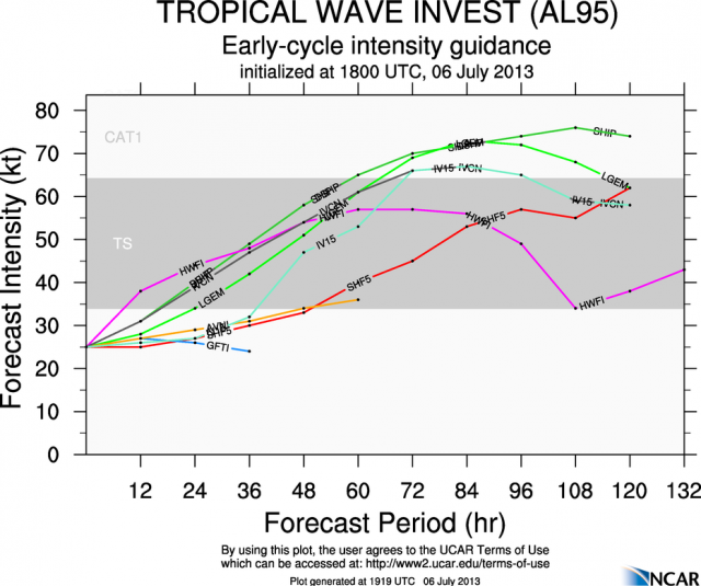
18Z Guidance from Colorado State for track and intensity. Consensus has a hurricane approaching the islands at 72 hours:


0 likes
-
ozonepete
- Professional-Met
- Posts: 4743
- Joined: Mon Sep 07, 2009 3:23 pm
- Location: From Ozone Park, NYC / Now in Brooklyn, NY
Re: ATL: INVEST 95L - Models
That's how it looks now but of course 5 or more days out is just impossible to forecast. The Bermuda high could extend well westward by then or contract eastward. The current forecast is for troughing in the eastern U.S. by next weekend which would pull it north. But still, just way too far out.
0 likes
-
ozonepete
- Professional-Met
- Posts: 4743
- Joined: Mon Sep 07, 2009 3:23 pm
- Location: From Ozone Park, NYC / Now in Brooklyn, NY
Re: ATL: INVEST 95L - Discussion
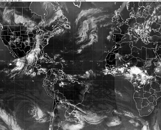
Very early start to the Cape Verde season. You can see 95L out there in the middle of the Atlantic and impressive easterly wave action continues over Africa. Look at that huge one blowing up over Africa now.

0 likes
-
Hurricane Andrew

- S2K Supporter

- Posts: 1891
- Age: 27
- Joined: Sun May 23, 2010 2:53 pm
- Location: KS
Amazing structure. New Forecast by me.
The posts in this forum are NOT official forecast and should not be used as such. They are just the opinion of the poster and may or may not be backed by sound meteorological data. They are NOT endorsed by any professional institution or storm2k.org. For official information, please refer to the NHC and NWS products.
Chance of Development
Storm: 95L
Forecast: 2
48 Hours: 40%
72 Hours: 50%
120 Hours: 50%
0 likes
The Enthusiast
NREMT-AEMT, WX nerd
Irene '11, Sandy '12, Irma '17 (SAR)
"Hard to think we were born to live this way..." -Wage War
-
ouragans

- Category 2

- Posts: 501
- Age: 54
- Joined: Sun Jun 12, 2011 12:09 pm
- Location: Abymes, Guadeloupe F.W.I
- Contact:
Re: Re:
cycloneye wrote:Hurricane Andrew wrote:Even from an Antilles base?
Even from Barbados.
and they won't use a drone for just an Invest. If it was a TS ou minimal hurricane, they would have sent one by Sunday or Monday. Hurricane Hunters don't have that range to reach where 95L should be before Tuesday
0 likes
Personal forecast disclaimer
This post is a personal point of view, not an information. Please refer to official statements for life-threatening decisions.
David '79, Frederic '79, Hugo '89, Iris, Luis & Marilyn '95, Georges '98, Lenny '99, Dean '07, Irma '17, Maria '17, Fiona '22, Philippe '23, Tammy '23
16°13'33.3,"6N -61°36'39.5"W
-
ouragans
- Category 2
- Posts: 501
- Age: 54
- Joined: Sun Jun 12, 2011 12:09 pm
- Location: Abymes, Guadeloupe F.W.I
- Contact:
Re: ATL: INVEST 95L - Discussion
ozonepete wrote:Look at that huge one blowing up over Africa now.
this area over Souther Chad definitely needs to be monitored... 95L should clean up the air before that one comes out.
0 likes
Personal forecast disclaimer
This post is a personal point of view, not an information. Please refer to official statements for life-threatening decisions.
David '79, Frederic '79, Hugo '89, Iris, Luis & Marilyn '95, Georges '98, Lenny '99, Dean '07, Irma '17, Maria '17, Fiona '22, Philippe '23, Tammy '23
16°13'33.3,"6N -61°36'39.5"W
This post is a personal point of view, not an information. Please refer to official statements for life-threatening decisions.
David '79, Frederic '79, Hugo '89, Iris, Luis & Marilyn '95, Georges '98, Lenny '99, Dean '07, Irma '17, Maria '17, Fiona '22, Philippe '23, Tammy '23
16°13'33.3,"6N -61°36'39.5"W
-
Hurricane Andrew
- S2K Supporter
- Posts: 1891
- Age: 27
- Joined: Sun May 23, 2010 2:53 pm
- Location: KS

Re:
Alyono wrote:If this does not develop within 48 hours, it isn't going to, at least not until it reaches the WC. Appears as if there will be too much shear in the EC to allow development
good point....the last GFS run I saw open this up as it entered the Carib.....took the wave under all the islands...
0 likes
Who is online
Users browsing this forum: No registered users and 78 guests