Well,they leave it as TD:
BULLETIN
TROPICAL DEPRESSION TWO ADVISORY NUMBER 6
NWS NATIONAL HURRICANE CENTER MIAMI FL AL022013
400 PM CDT TUE JUN 18 2013
...TROPICAL DEPRESSION EXPECTED TO MOVE OVER THE SOUTHERN BAY OF
CAMPECHE...
SUMMARY OF 400 PM CDT...2100 UTC...INFORMATION
----------------------------------------------
LOCATION...18.3N 91.9W
ABOUT 20 MI...35 KM SSW OF CARMEN MEXICO
ABOUT 165 MI...265 KM E OF COATZACOALCOS MEXICO
MAXIMUM SUSTAINED WINDS...30 MPH...45 KM/H
PRESENT MOVEMENT...WNW OR 300 DEGREES AT 10 MPH...17 KM/H
MINIMUM CENTRAL PRESSURE...1007 MB...29.74 INCHES
TCDAT2
TROPICAL DEPRESSION TWO DISCUSSION NUMBER 6
NWS NATIONAL HURRICANE CENTER MIAMI FL AL022013
400 PM CDT TUE JUN 18 2013
A FEW HOURS AGO I WAS TEMPTED TO DECLARE THE DEPRESSION A REMNANT
LOW. HOWEVER...CURRENT VISIBLE SATELLITE IMAGERY AND SURFACE DATA
FROM MEXICO STILL SHOWS A LARGE CIRCULATION WITH ENOUGH DEEP
CONVECTION TO MAINTAIN THE STATUS AS A TROPICAL DEPRESSION AT THIS
TIME. THE NORTHERN PORTION OF THE CIRCULATION IS ALREADY OVER THE
SOUTHERN BAY OF CAMPECHE WHERE SOME CONVECTIVE BANDS ARE
REDEVELOPING. ASSUMING THAT THE DEPRESSION MAINTAINS OR IMPROVES ITS
CURRENT STRUCTURE...TROPICAL STORM WATCHES OR WARNINGS FOR A
PORTION OF THE MEXICAN COAST WOULD BE REQUIRED THIS EVENING.
THE INITIAL MOTION IS HIGHLY UNCERTAIN AND THE DEPRESSION APPEARS TO
BE MOVING TOWARD THE WEST-NORTHWEST OR 300 DEGREES AT 9 KNOTS. THE
CURRENT TROUGH OVER THE CENTRAL GULF OF MEXICO IS FORECAST BY THE
GLOBAL MODELS TO BE REPLACED BY A NARROW RIDGE. THIS PATTERN SHOULD
KEEP THE CYCLONE MOVING SLOWLY WEST-NORTHWESTWARD AND THEN WESTWARD
OVER THE EXTREME SOUTHERN BAY OF CAMPECHE FOR THE NEXT TWO DAYS OR
SO...UNTIL THE DEPRESSION MOVES INLAND OVER MEXICO.
REGARDLESS OF THE EXACT TRACK OF THE CENTER AND WHETHER THE CYCLONE
DISSIPATES OR STRENGTHENS A LITTLE DURING THE NEXT COUPLE OF
DAYS...THE PRIMARY CONCERN CONTINUES TO BE HEAVY RAINFALL...WHICH
COULD CAUSE SIGNIFICANT FLOODING OVER PORTIONS OF CENTRAL AMERICA
AND EASTERN MEXICO.
FORECAST POSITIONS AND MAX WINDS
INIT 18/2100Z 18.3N 91.9W 25 KT 30 MPH
12H 19/0600Z 18.7N 93.3W 25 KT 30 MPH
24H 19/1800Z 19.0N 95.0W 30 KT 35 MPH
36H 20/0600Z 19.0N 96.0W 30 KT 35 MPH
48H 20/1800Z 19.0N 97.0W 20 KT 25 MPH...POST-TROP/REMNT LOW
72H 21/1800Z...DISSIPATED
$$
FORECASTER AVILA
ATL: BARRY - Post-Tropical
Moderator: S2k Moderators
-
cycloneye

- Admin

- Posts: 149682
- Age: 69
- Joined: Thu Oct 10, 2002 10:54 am
- Location: San Juan, Puerto Rico
Re: ATL: TWO -Tropical Depression
0 likes
Visit the Caribbean-Central America Weather Thread where you can find at first post web cams,radars
and observations from Caribbean basin members Click Here
and observations from Caribbean basin members Click Here
-
wxman57

- Moderator-Pro Met

- Posts: 23175
- Age: 68
- Joined: Sat Jun 21, 2003 8:06 pm
- Location: Houston, TX (southwest)
Re: ATL: TWO -Tropical Depression
alan1961 wrote:wxman57 wrote:Very weak swirl marking what's left of the LLC is located 30 miles due south of Ciudad del Carmen near 18.2N/91.8W. It's about to move offshore. Nothing but some low-level stratus near this center. No squalls. Regeneration still possible over the extreme southern BoC tonight. No threat of it moving northward out of the BoC.
Would you say its about roughly here wxman57?, obviously this image
is about from 2pm so it will be nearer the coast now
http://img534.imageshack.us/img534/4060/rqio.gif
Yes, that's it. I see the NHC decided not to downgrade it, though I don't think it qualifies as a TD due to the lack of any organized convection anywhere near that swirl. Remnant lows can have a circulation, too. Main reason they changed their mind is that calling it a TD would allow them to continue issuing advisories for a system that's about to move offshore. Good move on their part to continue the advisories. Killing it then restarting advisories in 12 hours would have caused confusion and resulted in less warning for those in its path.
0 likes
-
cycloneye
- Admin
- Posts: 149682
- Age: 69
- Joined: Thu Oct 10, 2002 10:54 am
- Location: San Juan, Puerto Rico
Re: ATL: TWO -Tropical Depression
0 likes
Visit the Caribbean-Central America Weather Thread where you can find at first post web cams,radars
and observations from Caribbean basin members Click Here
and observations from Caribbean basin members Click Here
-
MGC

- S2K Supporter

- Posts: 5941
- Joined: Sun Mar 23, 2003 9:05 pm
- Location: Pass Christian MS, or what is left.
Re: ATL: TWO -Tropical Depression
It does look like a remnant low...but, since it is going to move into the BOC soon, I think it is prudent to continue issuing advisories incase regeneration occurs. Convection need to fire quickly if there is any chance of 02L becoming a TS before landfall.....MGC
0 likes
-
ozonepete
- Professional-Met

- Posts: 4743
- Joined: Mon Sep 07, 2009 3:23 pm
- Location: From Ozone Park, NYC / Now in Brooklyn, NY
Re: ATL: TWO -Tropical Depression
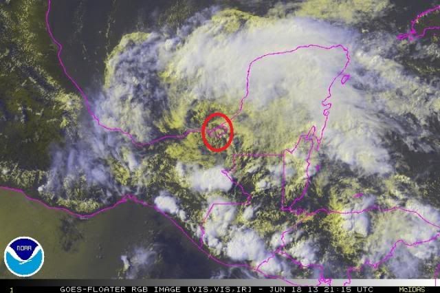
LLC clearly visible now (circled). Looks to have a good shot at TS since its northward jog today will ultimately allow it more time over water. And convection is obviously starting to grow rapidly in the northern semicircle, and even some popping south of the center now.

0 likes
-
hurricanekid416
- Tropical Storm

- Posts: 179
- Joined: Wed Oct 24, 2012 2:43 pm
What would the odds be of this becoming barry
0 likes
Personal Forecast Disclaimer:
The posts in this forum are NOT official forecast and should not be used as such. They are just the opinion of the poster and may or may not be backed by sound meteorological data. They are NOT endorsed by any professional institution or storm2k.org. For official information, please refer to the NHC and NWS products.
The posts in this forum are NOT official forecast and should not be used as such. They are just the opinion of the poster and may or may not be backed by sound meteorological data. They are NOT endorsed by any professional institution or storm2k.org. For official information, please refer to the NHC and NWS products.
-
ozonepete
- Professional-Met
- Posts: 4743
- Joined: Mon Sep 07, 2009 3:23 pm
- Location: From Ozone Park, NYC / Now in Brooklyn, NY
Re:
hurricanekid416 wrote:What would the odds be of this becoming barry
I guess everybody has their own opinion right now and I'll bet most people are 50-50 or 60-40 that it will make TS. I'm going 70-30 that it makes TS Barry by tomorrow afternoon. Just my opinion but I'm basing that on the fact that it has a moist environment, very warm SSTs, little shear and good upper level conditions for outflow.
Btw, the only big negative is proximity to land but this is an area where historically tropical cyclones often develop even when the COC is close to shore.
0 likes
-
hurricanekid416
- Tropical Storm
- Posts: 179
- Joined: Wed Oct 24, 2012 2:43 pm
Re: Re:
ozonepete wrote:hurricanekid416 wrote:What would the odds be of this becoming barry
I guess everybody has their own opinion right now and I'll bet most people are 50-50 or 60-40 that it will make TS. I'm going 70-30 that it makes TS Barry by tomorrow afternoon. Just my opinion but I'm basing that on the fact that it has a moist environment, very warm SSTs, little shear and good upper level conditions for outflow.
Btw, the only big negative is proximity to land but this is an area where historically tropical cyclones often develop even when the COC is close to shore.
That's a good estimate especially when you look at the systems that have spun up quickly in the bay of campeche an example is hurricane Karl 2 years ago
0 likes
Personal Forecast Disclaimer:
The posts in this forum are NOT official forecast and should not be used as such. They are just the opinion of the poster and may or may not be backed by sound meteorological data. They are NOT endorsed by any professional institution or storm2k.org. For official information, please refer to the NHC and NWS products.
The posts in this forum are NOT official forecast and should not be used as such. They are just the opinion of the poster and may or may not be backed by sound meteorological data. They are NOT endorsed by any professional institution or storm2k.org. For official information, please refer to the NHC and NWS products.

staring at visible loops, maybe I'm tired and my eyes are playing tricks on me, but it almost looks as if the center has been taking a more NW movement all day and seems that its about to emerge over water shortly near Ciudad del Carmen.
0 likes
The above post is not official and should not be used as such. It is the opinion of the poster and may or may not be backed by sound meteorological data. It is not endorsed by any professional institution or storm2k.org. For official information, please refer to the NHC and NWS products.
-
Hurricaneman

- Category 5

- Posts: 7404
- Age: 45
- Joined: Tue Aug 31, 2004 3:24 pm
- Location: central florida
Re: ATL: TWO -Tropical Depression
I wouldn't be suprised if convection refired and this made a run at TS strength tomorrow
0 likes
-
cycloneye
- Admin
- Posts: 149682
- Age: 69
- Joined: Thu Oct 10, 2002 10:54 am
- Location: San Juan, Puerto Rico
Re: ATL: TWO -Tropical Depression
Hurricaneman wrote:I wouldn't be suprised if convection refired and this made a run at TS strength tomorrow
And let's see if when recon goes on Wednesday afternoon it finds a well organized TD or maybe more than that.
Code: Select all
WEATHER RECONNAISSANCE FLIGHTS
CARCAH, NATIONAL HURRICANE CENTER, MIAMI, FL.
1020 AM EDT TUE 18 JUNE 2013
SUBJECT: TROPICAL CYCLONE PLAN OF THE DAY (TCPOD)
         VALID 19/1100Z TO 20/1100Z JUNE 2013
         TCPOD NUMBER.....13-018

I.  ATLANTIC REQUIREMENTS
    1. TROPICAL DEPRESSION TWO -- BAY OF CAMPECHE
       FLIGHT ONE -- TEAL 70      FLIGHT TWO -- TEAL 71
       A. 19/1800Z                A. 20/1200Z
       B. AFXXX 0102A CYCLONE     B. AFXXX 0202A CYCLONE
       C. 19/1430Z                C. 20/0815Z
       D. 18.8N 93.8W             D. 19.1N 95.4W
       E. 19/1700 TO 19/2100Z     E. 20/1100Z TO 20/1500Z
       F. SFC TO 10,000 FT        F. SFC TO 10,000 FT

    2. OUTLOOK FOR SUCCEEDING DAY.....NEGATIVE.
    3. REMARKS: INVEST FOR 18/2000Z AND FIX MISSION FOR
       19/1200Z ON THIS SYSTEM CANCELED BY NHC AT 18/1230Z
0 likes
Visit the Caribbean-Central America Weather Thread where you can find at first post web cams,radars
and observations from Caribbean basin members Click Here
and observations from Caribbean basin members Click Here

Re: ATL: TWO -Tropical Depression
Radar image, covection firing up nicely on the eastern quadrant of the COC.

0 likes
-
cycloneye
- Admin
- Posts: 149682
- Age: 69
- Joined: Thu Oct 10, 2002 10:54 am
- Location: San Juan, Puerto Rico
Re: ATL: TWO -Tropical Depression
00z Best Track
AL, 02, 2013061900, , BEST, 0, 188N, 924W, 25, 1007, TD
ftp://ftp.nhc.noaa.gov/atcf/tcweb/inves ... 013.invest
AL, 02, 2013061900, , BEST, 0, 188N, 924W, 25, 1007, TD
ftp://ftp.nhc.noaa.gov/atcf/tcweb/inves ... 013.invest
0 likes
Visit the Caribbean-Central America Weather Thread where you can find at first post web cams,radars
and observations from Caribbean basin members Click Here
and observations from Caribbean basin members Click Here

Re: ATL: TWO -Tropical Depression
Nice burst around the center in the last few frames. Looks to be on its way to Barry by tomorrow. This might get stronger than people expect.
http://www.ssd.noaa.gov/PS/TROP/floaters/02L/imagery/rgb-animated.gif
http://www.ssd.noaa.gov/PS/TROP/floaters/02L/imagery/rgb-animated.gif
0 likes
The following post is NOT an official forecast and should not be used as such. It is just the opinion of the poster and may or may not be backed by sound meteorological data. It is NOT endorsed by any professional institution including storm2k.org For Official Information please refer to the NHC and NWS products.
-
Hurricanehink

- S2K Supporter
- Posts: 2046
- Joined: Sun Nov 16, 2003 2:05 pm
- Location: New Jersey
Re: ATL: TWO -Tropical Depression
If this does become Barry, it reminds me of another season where the A storm originated in the Caribbean and struck the northern Gulf coast as a TS, followed by the B storm hitting Mexico from the Bay of Campeche, both of which in June. If that's the case, I hope Karen breaks the trend!
0 likes
Re: ATL: TWO -Tropical Depression
Hurricanehink wrote:If this does become Barry, it reminds me of another season where the A storm originated in the Caribbean and struck the northern Gulf coast as a TS, followed by the B storm hitting Mexico from the Bay of Campeche, both of which in June. If that's the case, I hope Karen breaks the trend!
Karen? Lets not have a repeat of the C, D, and E storms!
0 likes
-
hurricanefloyd5

- Category 5
- Posts: 1659
- Age: 45
- Joined: Sun May 02, 2004 10:53 am
- Location: Spartanburg
- Contact:
Re: ATL: TWO -Tropical Depression
When is the next advisory coming out it should be out now right is it tropical storm Barry
0 likes
-
cycloneye
- Admin
- Posts: 149682
- Age: 69
- Joined: Thu Oct 10, 2002 10:54 am
- Location: San Juan, Puerto Rico
Re: ATL: TWO -Tropical Depression
BULLETIN
TROPICAL DEPRESSION TWO ADVISORY NUMBER 7
NWS NATIONAL HURRICANE CENTER MIAMI FL AL022013
1000 PM CDT TUE JUN 18 2013
...TROPICAL DEPRESSION MOVES OVER THE SOUTHERN BAY OF
CAMPECHE...
...TROPICAL STORM WATCH ISSUED FOR A PORTION OF SOUTHERN MEXICO...
SUMMARY OF 1000 PM CDT...0300 UTC...INFORMATION
-----------------------------------------------
LOCATION...18.9N 92.7W
ABOUT 60 MI...100 KM WNW OF CIUDAD DEL CARMEN MEXICO
ABOUT 120 MI...195 KM ENE OF COATZACOALCOS MEXICO
MAXIMUM SUSTAINED WINDS...30 MPH...45 KM/H
PRESENT MOVEMENT...WNW OR 300 DEGREES AT 12 MPH...19 KM/H
MINIMUM CENTRAL PRESSURE...1007 MB...29.74 INCHES
TROPICAL DEPRESSION TWO DISCUSSION NUMBER 7
NWS NATIONAL HURRICANE CENTER MIAMI FL AL022013
1000 PM CDT TUE JUN 18 2013
SATELLITE AND RADAR DATA INDICATE THAT THE CENTER OF THE
DEPRESSION HAS EMERGED OVER THE EXTREME SOUTHERN BAY OF
CAMPECHE THIS EVENING. DURING THE PAST FEW HOURS...CONVECTION HAS
REDEVELOPED NEAR THE CENTER IN A BAND OVER THE NORTHEAST AND
EASTERN PORTIONS OF THE CIRCULATION. A SATELLITE INTENSITY
ESTIMATE FROM TAFB SUPPORTS MAINTAINING AN INITIAL INTENSITY
OF 25 KT.
THE DEPRESSION HAS SHOWN NO SIGNS OF SLOWING DOWN. THE INITIAL
MOTION ESTIMATE IS 300 DEGREES AT 10 KNOTS. THE TRACK GUIDANCE
INSISTS THAT THE FORWARD SPEED OF THE CYCLONE WILL DECREASE AND
BEND WESTWARD AS IT APPROACHES THE COAST OF MEXICO ON WEDNESDAY.
THE UPDATED NHC TRACK FORECAST IS SLIGHTLY NORTH OF THE PREVIOUS
ADVISORY AT 12 AND 24 HOURS DUE TO A MORE NORTHWARD INITIAL
POSITION. AFTER THAT TIME...THE OFFICIAL FORECAST IS VERY SIMILAR
TO THE PREVIOUS ADVISORY AND IS NEAR THE MIDDLE OF THE GUIDANCE
ENVELOPE.
THE DEPRESSION IS FORECAST TO REMAIN IN AN ENVIRONMENT OF MODERATE
SOUTHWESTERLY SHEAR DURING THE NEXT DAY OR SO. AS A RESULT...THE
INTENSITY GUIDANCE DOES NOT SHOW MUCH STRENGTHENING. THE NHC
FORECAST CALLS FOR SOME SLIGHT INTENSIFICATION AND ALTHOUGH IT IS
NOT EXPLICITLY FORECAST...THE DEPRESSION COULD ATTAIN TROPICAL
STORM STRENGTH BEFORE LANDFALL IN MEXICO. IN FACT...BASED ON THE NHC
INTENSITY FORECAST AND TYPICAL NHC FORECAST ERRORS...THERE IS ABOUT
A 40 PERCENT CHANCE OF THE CYCLONE BEING A TROPICAL STORM IN 24
HOURS. BECAUSE OF THAT POSSIBILITY...THE GOVERNMENT OF MEXICO HAS
ISSUED A TROPICAL STORM WATCH FOR A PORTION OF THE COAST OF
SOUTHERN MEXICO.
REGARDLESS OF THE EXACT TRACK AND WHETHER THE CYCLONE STRENGTHENS...
THE MAIN THREAT CONTINUES TO BE HEAVY RAINFALL...WHICH COULD CAUSE
SIGNIFICANT FLOODING OVER PORTIONS OF CENTRAL AMERICA AND
SOUTHERN MEXICO.
FORECAST POSITIONS AND MAX WINDS
INIT 19/0300Z 18.9N 92.7W 25 KT 30 MPH
12H 19/1200Z 19.2N 94.2W 30 KT 35 MPH
24H 20/0000Z 19.2N 95.2W 30 KT 35 MPH
36H 20/1200Z 19.0N 96.4W 30 KT 35 MPH...INLAND
48H 21/0000Z 19.0N 97.5W 20 KT 25 MPH...POST-TROP/REMNT LOW
72H 22/0000Z...DISSIPATED
$$
FORECASTER BROWN
0 likes
Visit the Caribbean-Central America Weather Thread where you can find at first post web cams,radars
and observations from Caribbean basin members Click Here
and observations from Caribbean basin members Click Here
-
MGC
- S2K Supporter
- Posts: 5941
- Joined: Sun Mar 23, 2003 9:05 pm
- Location: Pass Christian MS, or what is left.
Re: ATL: TWO -Tropical Depression
Nice convective burst near the center. The northward jog today will allow the cyclone to remain over the BOC a bit long. This should be sufficient to allow the depression to intensify to a TS before landfall......MGC
The above is the opinion of MGC and not an official forecast.
The above is the opinion of MGC and not an official forecast.
0 likes
Who is online
Users browsing this forum: No registered users and 143 guests