
BTW- they took the floater off it..
ATL: INVEST 92L
Moderator: S2k Moderators
Re: ATL: INVEST 92L
BTW- they took the floater off it..
0 likes
-
ozonepete
- Professional-Met

- Posts: 4743
- Joined: Mon Sep 07, 2009 3:23 pm
- Location: From Ozone Park, NYC / Now in Brooklyn, NY
Re: ATL: INVEST 92L
ROCK wrote::uarrow: only problem is there is not much left to regenerate. That LLC is winding down with no convection to sustain it. But I guess you never know....most of the globals dont do much with it so far...
BTW- they took the floater off it..
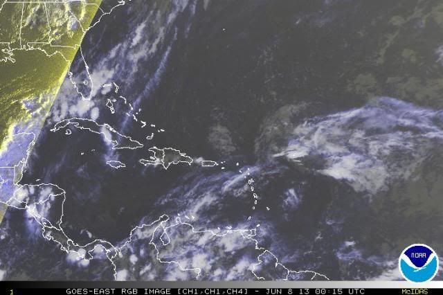
Yeah, there actually is no LLC anymore. It's a wave. But if you look at the RGB or visible loops it has very strong curvature, i.e. vorticity is still present. Look at the 850 mb vorticity it still has on the CIMSS chart below. So all you need is low shear and a moist mid-level environment, which it's got, and it can start producing convection again quickly, which in turn can produce a new closed low. I expect convection to really blow up over this tomorrow. Not saying any more than that for now.

0 likes
-
floridasun78
- Category 5

- Posts: 3755
- Joined: Sun May 17, 2009 10:16 pm
- Location: miami fl
Re: ATL: INVEST 92L
gone!!!!!!
TROPICAL WEATHER OUTLOOK
NWS NATIONAL HURRICANE CENTER MIAMI FL
800 PM EDT FRI JUN 7 2013
FOR THE NORTH ATLANTIC...CARIBBEAN SEA AND THE GULF OF MEXICO...
THE NATIONAL HURRICANE CENTER IS ISSUING ADVISORIES ON POST-TROPICAL
CYCLONE ANDREA...LOCATED NEAR THE U.S. MID-ATLANTIC COAST.
ELSEWHERE...TROPICAL CYCLONE FORMATION IS NOT EXPECTED DURING THE
NEXT 48 HOURS.
$$
FORECASTER CANGIALOSI
0 likes
-
floridasun78
- Category 5
- Posts: 3755
- Joined: Sun May 17, 2009 10:16 pm
- Location: miami fl
-
cycloneye

- Admin

- Posts: 149671
- Age: 69
- Joined: Thu Oct 10, 2002 10:54 am
- Location: San Juan, Puerto Rico
Re: ATL: INVEST 92L
NHC_ATCF
invest_DEACTIVATE_al922013.ren
FSTDA
R
U
040
010
0000
201306072344
NONE
NOTIFY=ATRP
END
ftp://ftp.nhc.noaa.gov/atcf/tcweb/inves ... 922013.ren
It was a very impressive system but conditions didn't allow for it to develop. But it sends an important message that things could be very active from West Africa to the Lesser Antilles later in the season and those who live in hurricane alley (Me included) must prepare for a loooong CV Season.
0 likes
Visit the Caribbean-Central America Weather Thread where you can find at first post web cams,radars
and observations from Caribbean basin members Click Here
and observations from Caribbean basin members Click Here
-
floridasun78
- Category 5
- Posts: 3755
- Joined: Sun May 17, 2009 10:16 pm
- Location: miami fl
-
ozonepete
- Professional-Met
- Posts: 4743
- Joined: Mon Sep 07, 2009 3:23 pm
- Location: From Ozone Park, NYC / Now in Brooklyn, NY
Re: ATL: INVEST 92L
I know that the NHC and everyone else isn't covering it anymore. I thought that was obvious (??) Every season many waves start to develop into a tropical depression and get an invest number and then get sheared and lose the invest and then come back again. Is everyone missing my point that the tropical wave is still there and moving into a favorable area for regeneration and some possible development north of Puerto Rico tomorrow? That's all I was saying.
I circled the very strong wave here:
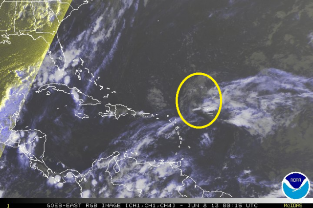

I circled the very strong wave here:

0 likes
-
cycloneye
- Admin
- Posts: 149671
- Age: 69
- Joined: Thu Oct 10, 2002 10:54 am
- Location: San Juan, Puerto Rico
Re:
floridasun78 wrote:so topic going close soon?
It stays here until further notice as things could change as our friend ozonepete said. Also,as replies continue to be posted, is the main reason it remains here.
0 likes
Visit the Caribbean-Central America Weather Thread where you can find at first post web cams,radars
and observations from Caribbean basin members Click Here
and observations from Caribbean basin members Click Here
-
cycloneye
- Admin
- Posts: 149671
- Age: 69
- Joined: Thu Oct 10, 2002 10:54 am
- Location: San Juan, Puerto Rico
Re:
CrazyC83 wrote:The rule I thought is 48 hours after deactivation?
There are no timetables about moving a thread from active storms/invests forum to the archieves one. If members continue to have discussions about any post tropical or post invest deactivation threads,then there is no problem to maintain it here.
0 likes
Visit the Caribbean-Central America Weather Thread where you can find at first post web cams,radars
and observations from Caribbean basin members Click Here
and observations from Caribbean basin members Click Here
-
Aric Dunn
- Category 5
- Posts: 21238
- Age: 43
- Joined: Sun Sep 19, 2004 9:58 pm
- Location: Ready for the Chase.
- Contact:
pretty impressive still considering the conditions.. lets see what happens as it approaches the lower shear. tomorrow.
0 likes
Note: If I make a post that is brief. Please refer back to previous posts for the analysis or reasoning. I do not re-write/qoute what my initial post said each time.
If there is nothing before... then just ask
Space & Atmospheric Physicist, Embry-Riddle Aeronautical University,
I believe the sky is falling...
If there is nothing before... then just ask
Space & Atmospheric Physicist, Embry-Riddle Aeronautical University,
I believe the sky is falling...
Re: ATL: INVEST 92L
whats left of the circulation is right on top of PR at the moment. No convection except to the north. Still sheared like a big dog....no globals show any regeneration but you never know I guess.....
0 likes
-
ozonepete
- Professional-Met
- Posts: 4743
- Joined: Mon Sep 07, 2009 3:23 pm
- Location: From Ozone Park, NYC / Now in Brooklyn, NY
Re: ATL: INVEST 92L
Yeah , Rock, you can see the low level swirl passing just north of Puerto Rico now. I'm less bullish on seeing this rejuvenate now because as you said, the models don't do anything with it as of now and I don't see any lower level convergence or upper divergence over the area. However Aric is right that it will enter a low shear zone tomorrow and it still has a lot of 850 mb vorticity with it. Can't hurt to watch it.
0 likes
-
Annie Oakley

- Category 5
- Posts: 1103
- Joined: Tue Jul 31, 2007 12:54 pm
- Location: Texas
Re: ATL: INVEST 92L
ozonepete wrote:Yeah , Rock, you can see the low level swirl passing just north of Puerto Rico now. I'm less bullish on seeing this rejuvenate now because as you said, the models don't do anything with it as of now and I don't see any lower level convergence or upper divergence over the area. However Aric is right that it will enter a low shear zone tomorrow and it still has a lot of 850 mb vorticity with it. Can't hurt to watch it.
So it is going to behave as a solar flare would?
0 likes
-
ozonepete
- Professional-Met
- Posts: 4743
- Joined: Mon Sep 07, 2009 3:23 pm
- Location: From Ozone Park, NYC / Now in Brooklyn, NY
Re: ATL: INVEST 92L
Ha ha it just might actually. Convection could flare up over it tomorrow as it goes north of the DR and then there's a second zone of shear north of eastern Cuba that that might kill it again, although that shear is lower and diminishing. The fun of watching it now is just to see what happens tomorrow. Such a strong low-level area of vorticity should usually initiate convection when there's no shear overhead and the area is moist at mid-levels. So we would expect that to happen here. It is a classic case where we can learn something by observation. If the convection doesn't flare we will try to figure out why.
0 likes
-
Annie Oakley
- Category 5
- Posts: 1103
- Joined: Tue Jul 31, 2007 12:54 pm
- Location: Texas
-
gatorcane

- S2K Supporter

- Posts: 23708
- Age: 48
- Joined: Sun Mar 13, 2005 3:54 pm
- Location: Boca Raton, FL
I really can't see how this will regenerate convection tomorrow despite more favorable upper-level winds. It's not generating any convection now near the center of the swirl at all. Shear has certainly done it's job in tearing away the rest of the convection to the northeast of the naked swirl that is trying to hang on.
0 likes
Re: ATL: INVEST 92L
0 likes
Who is online
Users browsing this forum: No registered users and 48 guests