ATL: ANDREA - Post-Tropical

Moderator: S2k Moderators

Message
Author
User avatar
GCANE
S2K Supporter
S2K Supporter
Posts: 11496
Joined: Mon Oct 22, 2007 8:03 am

Re: ATL: ANDREA - Tropical Storm

#1161 Postby GCANE » Thu Jun 06, 2013 6:04 am

jlauderdal wrote:
GCANE wrote:That band is becoming a decent looking MCS

http://www.nrlmry.navy.mil/tcdat/tc13/A ... .100pc.jpg


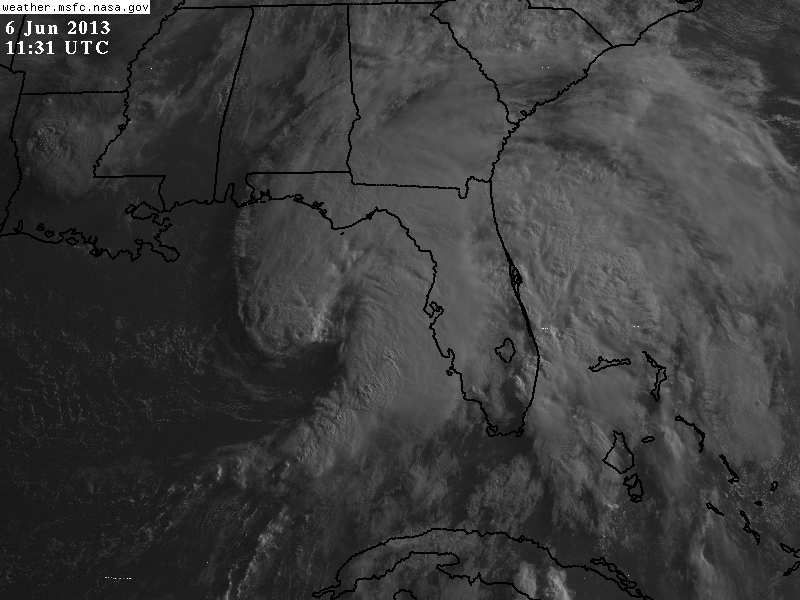
there is a decent amt of time for some heating to works its magic between band 1 and band 2, lets see if something can get going later this morning as band 1 moves out, the cloud deck is really thick right now so there is no heating to be had if this continues but it could open up in a couple of hours..band 1 has been a player, might be more impressive then band 2 when we do a wrap on andrea, at least for the southern half of the penninusla


Rain-rate increasing - it continues to strengthen.

http://www.nrlmry.navy.mil/nexdat/CONUS ... xico.0.jpg
0 likes   

User avatar
artist
Category 5
Category 5
Posts: 9792
Joined: Mon Jun 06, 2005 3:26 pm
Location: West Palm

#1162 Postby artist » Thu Jun 06, 2013 6:09 am

BULLETIN - EAS ACTIVATION REQUESTED
TORNADO WARNING
NATIONAL WEATHER SERVICE MELBOURNE FL
700 AM EDT THU JUN 6 2013

THE NATIONAL WEATHER SERVICE IN MELBOURNE HAS ISSUED A

* TORNADO WARNING FOR...
SOUTHEASTERN MARTIN COUNTY IN FLORIDA...
THIS INCLUDES THE CITY OF HOBE SOUND...

* UNTIL 730 AM EDT.

* AT 657 AM EDT...NATIONAL WEATHER SERVICE METEOROLOGISTS DETECTED A
SEVERE THUNDERSTORM CAPABLE OF PRODUCING A TORNADO 13 MILES
SOUTHWEST OF JONATHAN DICKINSON STATE PARK...OR 11 MILES SOUTHWEST
OF JUPITER...MOVING NORTH AT 25 MPH.

* OTHER LOCATIONS IN THE WARNING INCLUDE BUT ARE NOT LIMITED TO HOBE
SOUND WILDLIFE REFUGE. THIS CELL IS EXPECTED TO PASS OVER INTERSTATE
95 IN THE VICINITY OF STATE ROAD 76 AROUND 730 AM.
0 likes   

User avatar
artist
Category 5
Category 5
Posts: 9792
Joined: Mon Jun 06, 2005 3:26 pm
Location: West Palm

#1163 Postby artist » Thu Jun 06, 2013 6:10 am

BULLETIN - EAS ACTIVATION REQUESTED
TORNADO WARNING
NATIONAL WEATHER SERVICE MIAMI FL
659 AM EDT THU JUN 6 2013

THE NATIONAL WEATHER SERVICE IN MIAMI HAS ISSUED A

* TORNADO WARNING FOR...
NORTHEASTERN PALM BEACH COUNTY IN SOUTHEAST FLORIDA...

* UNTIL 730 AM EDT

* AT 657 AM EDT...NATIONAL WEATHER SERVICE DOPPLER RADAR INDICATED A
SEVERE THUNDERSTORM CAPABLE OF PRODUCING A TORNADO NEAR
WELLINGTON...MOVING NORTH AT 25 MPH. ANOTHER THUNDERSTORM JUST
WEST OF NORTH COUNTY AIRPORT IS ALSO CAPABLE OF PRODUCING A
TORNADO.

* THE TORNADO WILL BE NEAR...
WELLINGTON...
ROYAL PALM BEACH...
NORTH COUNTY AIRPORT...
AND SURROUNDING COMMUNITIES.
0 likes   

User avatar
GCANE
S2K Supporter
S2K Supporter
Posts: 11496
Joined: Mon Oct 22, 2007 8:03 am

Re: ATL: ANDREA - Tropical Storm

#1164 Postby GCANE » Thu Jun 06, 2013 6:12 am

0 likes   

User avatar
northjaxpro
S2K Supporter
S2K Supporter
Posts: 8900
Joined: Mon Sep 27, 2010 11:21 am
Location: Jacksonville, FL

#1165 Postby northjaxpro » Thu Jun 06, 2013 6:14 am

Good morning! Andrea has really surprised me as I awakened this morning to see that she has intensified and actually organized despite in the face of shear. Heay rain has already begun in the Jax metro marea and I like everyone in the state today will really be on extreme high alert with the threat of tornadoes today as Andrea will move right over the area through tonight. This is going to be quite an interesting during the next 18-24 hours around here that's for sure.
Last edited by northjaxpro on Thu Jun 06, 2013 6:15 am, edited 1 time in total.
0 likes   
NEVER, EVER SAY NEVER in the tropics and weather in general, and most importantly, with life itself!!

________________________________________________________________________________________

Fay 2008 Beryl 2012 Debby 2012 Colin 2016 Hermine 2016 Julia 2016 Matthew 2016 Irma 2017 Dorian 2019

User avatar
cycloneye
Admin
Admin
Posts: 145303
Age: 68
Joined: Thu Oct 10, 2002 10:54 am
Location: San Juan, Puerto Rico

Re: ATL: ANDREA - Tropical Storm

#1166 Postby cycloneye » Thu Jun 06, 2013 6:14 am

Long range.

Image
0 likes   
Visit the Caribbean-Central America Weather Thread where you can find at first post web cams,radars
and observations from Caribbean basin members Click Here

User avatar
northjaxpro
S2K Supporter
S2K Supporter
Posts: 8900
Joined: Mon Sep 27, 2010 11:21 am
Location: Jacksonville, FL

#1167 Postby northjaxpro » Thu Jun 06, 2013 6:19 am

A very impressive band with rainfall rates of nearly 2 inches per hour is currrently moving through the Jax metro area. Flooding definitely is a major concern today with the worst still to come as Andrea moves through late today.
0 likes   
NEVER, EVER SAY NEVER in the tropics and weather in general, and most importantly, with life itself!!

________________________________________________________________________________________

Fay 2008 Beryl 2012 Debby 2012 Colin 2016 Hermine 2016 Julia 2016 Matthew 2016 Irma 2017 Dorian 2019

User avatar
NDG
S2K Supporter
S2K Supporter
Posts: 15446
Joined: Sun Jul 09, 2006 10:14 pm
Location: Orlando, FL

Re: ATL: ANDREA - Tropical Storm

#1168 Postby NDG » Thu Jun 06, 2013 6:19 am

The next squall of Andrea approaching the west coast of FL could be really nasty. A little bit of daytime heating could be even worse.
0 likes   

User avatar
CronkPSU
S2K Supporter
S2K Supporter
Posts: 2014
Joined: Sun Aug 07, 2005 10:44 pm
Location: Avalon Park, FL

#1169 Postby CronkPSU » Thu Jun 06, 2013 6:23 am

I know these things are hard to predict but that is a huge dry slot over most of Cent Fl, are they expecting that to fill back in?
0 likes   
Just like Jon Snow..."I know nothing" except what I know, and most of what I know is gathered by the fine people of the NHC

User avatar
Fego
S2K Supporter
S2K Supporter
Posts: 767
Age: 65
Joined: Sun Apr 18, 2004 7:58 pm
Location: San Juan, Puerto Rico
Contact:

Re: ATL: ANDREA - Tropical Storm

#1170 Postby Fego » Thu Jun 06, 2013 6:23 am

Indeed those radar images show how the center of the storm is being covered by some convection.
0 likes   
Go Giants! Go Niners! Go Warriors!

User avatar
northjaxpro
S2K Supporter
S2K Supporter
Posts: 8900
Joined: Mon Sep 27, 2010 11:21 am
Location: Jacksonville, FL

Re: ATL: ANDREA - Tropical Storm

#1171 Postby northjaxpro » Thu Jun 06, 2013 6:28 am

NDG wrote:The next squall of Andrea approaching the west coast of FL could be really nasty. A little bit of daytime heating could be even worse.


Yes, that squall line from Andea looks very nasty indeed. I definitely see the threat of tornadoes and very strong winds as that line approaches the coast late this morning.
0 likes   
NEVER, EVER SAY NEVER in the tropics and weather in general, and most importantly, with life itself!!

________________________________________________________________________________________

Fay 2008 Beryl 2012 Debby 2012 Colin 2016 Hermine 2016 Julia 2016 Matthew 2016 Irma 2017 Dorian 2019

User avatar
NDG
S2K Supporter
S2K Supporter
Posts: 15446
Joined: Sun Jul 09, 2006 10:14 pm
Location: Orlando, FL

Re:

#1172 Postby NDG » Thu Jun 06, 2013 6:30 am

CronkPSU wrote:I know these things are hard to predict but that is a huge dry slot over most of Cent Fl, are they expecting that to fill back in?


IMO, that is going to make things worst if the sun comes out before that line of storms move inland later this morning or early afternoon, so yes I am expecting that squall to move through the Orlando area.

What a wet late Spring Apopka has had!
0 likes   

User avatar
northjaxpro
S2K Supporter
S2K Supporter
Posts: 8900
Joined: Mon Sep 27, 2010 11:21 am
Location: Jacksonville, FL

Re: ATL: ANDREA - Tropical Storm

#1173 Postby northjaxpro » Thu Jun 06, 2013 6:30 am

NDG wrote:The next squall of Andrea approaching the west coast of FL could be really nasty. A little bit of daytime heating could be even worse.


Yes, that squall line from Andrea looks very nasty indeed. I definitely see the threat of tornadoes and very strong winds as that line approaches the coast late this morning.
0 likes   
NEVER, EVER SAY NEVER in the tropics and weather in general, and most importantly, with life itself!!

________________________________________________________________________________________

Fay 2008 Beryl 2012 Debby 2012 Colin 2016 Hermine 2016 Julia 2016 Matthew 2016 Irma 2017 Dorian 2019

User avatar
CronkPSU
S2K Supporter
S2K Supporter
Posts: 2014
Joined: Sun Aug 07, 2005 10:44 pm
Location: Avalon Park, FL

Re: Re:

#1174 Postby CronkPSU » Thu Jun 06, 2013 6:39 am

NDG wrote:
CronkPSU wrote:I know these things are hard to predict but that is a huge dry slot over most of Cent Fl, are they expecting that to fill back in?


IMO, that is going to make things worst if the sun comes out before that line of storms move inland later this morning or early afternoon, so yes I am expecting that squall to move through the Orlando area.

What a wet late Spring Apopka has had!


yep but the lakes at camp were so low, I don't mind!
0 likes   
Just like Jon Snow..."I know nothing" except what I know, and most of what I know is gathered by the fine people of the NHC

User avatar
GCANE
S2K Supporter
S2K Supporter
Posts: 11496
Joined: Mon Oct 22, 2007 8:03 am

Re: ATL: ANDREA - Tropical Storm

#1175 Postby GCANE » Thu Jun 06, 2013 6:41 am

Palm Beach County, FL. Emerg. Crews reporting roofs missing and vehicles flipped over

Command set up at 76th Rd N. @ 130th (sounds like mult.injuries & bldgs damaged in area) unknown size of area damaged

http://twitter.com/res7cuefox5


Palm Beach County Fire Rescue Live Audio Feed

http://www.broadcastify.com/listen/feed/9219/web
0 likes   

gsytch
Category 1
Category 1
Posts: 401
Joined: Sun Jan 23, 2011 7:15 am

#1176 Postby gsytch » Thu Jun 06, 2013 6:41 am

The line is beginning to move ashore into Pinellas county and just near me (West Pasco coast). I am concerned for tornadoes. Last year we were hit by one, damage all over the neighborhood. Heavy rains have settled in, squally but not windy. Once again an early season tropical soaker! :wink:
0 likes   

tolakram
Admin
Admin
Posts: 20009
Age: 62
Joined: Sun Aug 27, 2006 8:23 pm
Location: Florence, KY (name is Mark)

Re: ATL: ANDREA - Tropical Storm

#1177 Postby tolakram » Thu Jun 06, 2013 6:47 am

latest

Image
0 likes   
M a r k
- - - - -
Join us in chat: Storm2K Chatroom Invite. Android and IOS apps also available.

The posts in this forum are NOT official forecasts and should not be used as such. Posts are NOT endorsed by any professional institution or STORM2K.org. For official information and forecasts, please refer to NHC and NWS products.

User avatar
NDG
S2K Supporter
S2K Supporter
Posts: 15446
Joined: Sun Jul 09, 2006 10:14 pm
Location: Orlando, FL

#1178 Postby NDG » Thu Jun 06, 2013 6:47 am

First Vis of Andrea, what a huge storm.

Image
0 likes   

User avatar
GCANE
S2K Supporter
S2K Supporter
Posts: 11496
Joined: Mon Oct 22, 2007 8:03 am

Re: ATL: ANDREA - Tropical Storm

#1179 Postby GCANE » Thu Jun 06, 2013 6:47 am

0 likes   

User avatar
GCANE
S2K Supporter
S2K Supporter
Posts: 11496
Joined: Mon Oct 22, 2007 8:03 am

Re: ATL: ANDREA - Tropical Storm

#1180 Postby GCANE » Thu Jun 06, 2013 6:48 am

GCANE wrote:Palm Beach County, FL. Emerg. Crews reporting roofs missing and vehicles flipped over

Command set up at 76th Rd N. @ 130th (sounds like mult.injuries & bldgs damaged in area) unknown size of area damaged

http://twitter.com/res7cuefox5


Palm Beach County Fire Rescue Live Audio Feed

http://www.broadcastify.com/listen/feed/9219/web


Traumatic injuries reported.
0 likes   


Return to “2013”

Who is online

Users browsing this forum: No registered users and 9 guests