ATL: INVEST 90L - Models
Moderator: S2k Moderators

-
Hurricane Andrew

- S2K Supporter

- Posts: 1891
- Age: 27
- Joined: Sun May 23, 2010 2:53 pm
- Location: KS
-
Incident_MET

- Professional-Met

- Posts: 63
- Joined: Tue Mar 28, 2006 10:22 pm
- Location: Floridana Beach, FL
Re:
artist wrote:and yet they just removed our Hydrologic Outlook for south Florida.
It wasn't removed. The date time stamp just expired from original issuance. Also Melbourne just issued a Hydrologic Outlook for their area.
http://www.srh.noaa.gov/productview.php ... MLB&max=61
0 likes
-
gatorcane

- S2K Supporter
- Posts: 23708
- Age: 48
- Joined: Sun Mar 13, 2005 3:54 pm
- Location: Boca Raton, FL
Re: Re:
Aric Dunn wrote:OuterBanker wrote:Aric, apparently I’m looking at the near surface mslp and precip. This is available through WeatherBell. Now that I have you, what are the best of each of the models. They do seem to have them all. And a short explanation of each (just the ones you recommend) would be greatly appreciated.
They all offer a perspective. though the consensus with the gfs and euro is your best bet and besides the intensity they are in general in agreement on something developing how organized and strength remains to be seen. they all should come more into agreement when there is a actual disturbance to focus on.
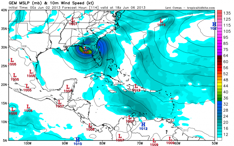
The CMC did get a SW upgrade for this year. So I am curious how it does this season.
Here is the 12Z CMC at 96 hours:

and at 120 hours it is quite bullish. Seems way too bullish to me:

0 likes
-
Hurricane Andrew
- S2K Supporter
- Posts: 1891
- Age: 27
- Joined: Sun May 23, 2010 2:53 pm
- Location: KS
-
Hurricaneman

- Category 5

- Posts: 7404
- Age: 45
- Joined: Tue Aug 31, 2004 3:24 pm
- Location: central florida
Re: ATL: INVEST 90L - Models
0zGFS is showing about the same up to about 96hrs, but is more robust after that than previous runs
0 likes
-
cycloneye

- Admin

- Posts: 149672
- Age: 69
- Joined: Thu Oct 10, 2002 10:54 am
- Location: San Juan, Puerto Rico
Re: ATL: INVEST 90L - Models
Hurricaneman wrote:0zGFS is showing about the same up to about 96hrs, but is more robust after that than previous runs
No split lows so far.

Landfall at 120 hours as a weak to moderate TS.

0 likes
Visit the Caribbean-Central America Weather Thread where you can find at first post web cams,radars
and observations from Caribbean basin members Click Here
and observations from Caribbean basin members Click Here
-
Hurricaneman
- Category 5
- Posts: 7404
- Age: 45
- Joined: Tue Aug 31, 2004 3:24 pm
- Location: central florida
Re: ATL: INVEST 90L - Models
Im thinking the split low thing was convective feedback, this run makes more sense if it were to form, the Canadian may be on to something seeing as the other models seem to be coming towards it in terms of intensity which means this could be a little more wind wise than expected
0 likes
Re: ATL: INVEST 90L - Models
Hurricaneman wrote:Im thinking the split low thing was convective feedback, this run makes more sense if it were to form, the Canadian may be on to something seeing as the other models seem to be coming towards it in terms of intensity which means this could be a little more wind wise than expected
The term convective feedback seems to be overused here
the split low is likely to be due to the fact that anything that forms is likely to be very broad and have multiple areas of rotation
0 likes

-
MiamiensisWx
The 00Z ECMWF actually strengthens the system from a weak TD (25 kt / 30 mph or less) to a minimal TS (40 kt / 45 mph) in the 24 hours before landfall near Tampa...a fairly significant shift.
Source
Between 96 and 120 hours (days 4-5) the 850-mb winds increase from <15 m/s to 22 m/s (= 38 kt / 44 mph at 10 m). The 12Z run yesterday showed a weakening TD at landfall...so the trend is toward lower net shear.
Source
Between 96 and 120 hours (days 4-5) the 850-mb winds increase from <15 m/s to 22 m/s (= 38 kt / 44 mph at 10 m). The 12Z run yesterday showed a weakening TD at landfall...so the trend is toward lower net shear.
0 likes
-
jlauderdal
- S2K Supporter
- Posts: 7240
- Joined: Wed May 19, 2004 5:46 am
- Location: NE Fort Lauderdale
- Contact:
Re:
my recommendation is that you put the canadian down a few pegs on the priority list...euro, gfs, hurricane models, all othersNDG wrote:CMC/GEM continues to be very bullish, I think is back to its old self, lol.
0 likes
-
Dean4Storms
- S2K Supporter
- Posts: 6358
- Age: 63
- Joined: Sun Aug 31, 2003 1:01 pm
- Location: Miramar Bch. FL
-
northjaxpro

- S2K Supporter
- Posts: 8900
- Joined: Mon Sep 27, 2010 11:21 am
- Location: Jacksonville, FL
Re:
Dean4Storms wrote:I think at this point it is safe to say intensity should remain under hurricane force and that landfall of whatever develops will be somewhere between Appalachicola and Tampa. Still think beach erosion and heavy rain will be the biggest concerns.
Yeah, I think we will be looking at a moderate trpical storm late this week. However, you never 100percent sure if this thing could get better organized and get stronger. Upper level shear should likely keep the system in check, but all it takes is for the shear to relax just a bit and we may be surprised. Unfortunately, the latest model runs looks like more heavy rainfaill is in store for my locale. This is something we don't need, like much of the peninsula. The models wll continue to fluctuate of course, but a landfall anywhere from Appalachicola to Tampa puts my area to get some substantial impacts (heavy rain, possible severe weather).
But, still lots can change, but suffice to say obviously it will be a very interesting week ahead.
0 likes
NEVER, EVER SAY NEVER in the tropics and weather in general, and most importantly, with life itself!!
________________________________________________________________________________________
Fay 2008 Beryl 2012 Debby 2012 Colin 2016 Hermine 2016 Julia 2016 Matthew 2016 Irma 2017 Dorian 2019
________________________________________________________________________________________
Fay 2008 Beryl 2012 Debby 2012 Colin 2016 Hermine 2016 Julia 2016 Matthew 2016 Irma 2017 Dorian 2019
-
MiamiensisWx
New 12Z GFS looks to be suffering from convective feedback yet again...it doesn't even develop the Yucatán low for more than three days, in contrast to what it showed on the 00Z run: a TS emerging into the SE Gulf. Otherwise, the UL pattern looks identical between the two runs.
00Z: http://mag.ncep.noaa.gov/gfs/00/gfs_wnatl_084_10m_wnd_precip.gif
12Z: http://mag.ncep.noaa.gov/gfs/12/gfs_wnatl_072_10m_wnd_precip.gif
00Z: http://mag.ncep.noaa.gov/gfs/00/gfs_wnatl_084_10m_wnd_precip.gif
12Z: http://mag.ncep.noaa.gov/gfs/12/gfs_wnatl_072_10m_wnd_precip.gif
0 likes
-
SFLcane

- S2K Supporter
- Posts: 10281
- Age: 48
- Joined: Sat Jun 05, 2010 1:44 pm
- Location: Lake Worth Florida
Re: ATL: INVEST 90L - Models
not much to see on the 12z gfs...plenty of tropical moisture for florida though. models have trended in keeping heaviest rainfall over the gulf.
0 likes
-
MiamiensisWx
Re: ATL: INVEST 90L - Models
The GFS is performing rather poorly re: convective evolution. The 00Z run only showed precipitation rates of .75-1.0" in six hours by 15Z near Chetumal, but satellite imagery shows widespread rates of 1.0" in just the past hour. This is associated with the strong convection ongoing near Cozumel and Chetumal. This underestimation of the rain rate also means that the model is underestimating upper-level warming / subsidence (height rises) induced by the said convection, which tends to increase UL divergence and reduce shear. I would clearly throw out the recent GFS solutions, including the 12Z run, which does not even show development or even bring the system out of the Yucatán peninsula. It now delays a U.S. impact until day six, if at all. The ECMWF, which shows landfall in five days and has been much more consistent in bringing the system off the Yucatán, seems much more reasonable.
Rain rates, current: http://www.ssd.noaa.gov/poes/tatl/flash-ssrr.html
00Z forecast for 15Z today: http://mag.ncep.noaa.gov/gfs/00/gfs_wnatl_015_10m_wnd_precip.gif
Rain rates, current: http://www.ssd.noaa.gov/poes/tatl/flash-ssrr.html
00Z forecast for 15Z today: http://mag.ncep.noaa.gov/gfs/00/gfs_wnatl_015_10m_wnd_precip.gif
0 likes
-
MiamiensisWx
Re: ATL: INVEST 90L - Models
The 12Z ECMWF is slower and stronger with the low in the Gulf, with 1006 mb (vs. 1007 mb at 00Z) at 96 hours and 1002 mb (hitting GA) at 120 hours. The FL landfall occurs around 108 hours, between the two frames, but since the pressure is so low in GA I would suspect that the Tampa landfall would have been 1003 mb or lower--at least as low as the 1003 mb on the preceding run. There is much less shear on the 12Z run due to better co-location between a mid-level and a low-level low.
http://raleighwx.americanwx.com/models/euro/12zeurotropical850mbVortSLP120.gif
http://raleighwx.americanwx.com/models/euro/12zeurotropical850mbVortSLP120.gif
0 likes
-
Hurricaneman
- Category 5
- Posts: 7404
- Age: 45
- Joined: Tue Aug 31, 2004 3:24 pm
- Location: central florida
Re: ATL: INVEST 90L - Models
Im going with the Euro because it has more consistency than the GFS and makes the most sense over the GFS silliness
0 likes
-
cycloneye
- Admin
- Posts: 149672
- Age: 69
- Joined: Thu Oct 10, 2002 10:54 am
- Location: San Juan, Puerto Rico
Re: ATL: INVEST 90L - Models
The question is if NHC will prefer the ECMWF,follow GFS or a blend.
0 likes
Visit the Caribbean-Central America Weather Thread where you can find at first post web cams,radars
and observations from Caribbean basin members Click Here
and observations from Caribbean basin members Click Here
Who is online
Users browsing this forum: No registered users and 102 guests