Texas Spring 2013

U.S. & Caribbean Weather Discussions and Severe Weather Events

Moderator: S2k Moderators

Forum rules

The posts in this forum are NOT official forecast and should not be used as such. They are just the opinion of the poster and may or may not be backed by sound meteorological data. They are NOT endorsed by any professional institution or STORM2K.

Help Support Storm2K
Message
Author
weatherdude1108
Category 5
Category 5
Posts: 4228
Joined: Tue Dec 13, 2011 1:04 pm
Location: Northwest Austin/Cedar Park, TX

Re:

#121 Postby weatherdude1108 » Tue Mar 12, 2013 11:18 pm

Ntxw wrote:I wouldn't say epic, you need a strong La Nina for that like 2011. That certainly isn't coming. It's been a cool March thanks to NW flow, better had it been in Jan and Feb than now huh :lol: mother nature toys with us.


[Edit: forgot to add south and east Texas to the filling up all the lakes comment.] :wink:
Yeah, that NW flow created frost in spots this morning in the grassy fields/vacant lots here in Austin! :cold: Caught me off guard.

Who knows? We may have 19 inches of rain in 24 hours next week in the Hill Country, north, west, south, and east Texas and fill up all the lakes in Texas. No telling what ole' Mother Nature has up her sleeve! :cheesy:
0 likes   

User avatar
Portastorm
Storm2k Moderator
Storm2k Moderator
Posts: 9914
Age: 63
Joined: Fri Jul 11, 2003 9:16 am
Location: Round Rock, TX
Contact:

Re: Texas Spring 2013

#122 Postby Portastorm » Wed Mar 13, 2013 1:37 pm

Well, I have no clue how accurate this guy is ... but if you go down several blog entries, he has a severe weather outlook for the spring. Dallas and Austin are both in the high risk zones. Hope he's right because that will mean ample rainfall. Or it should. :wink:

http://theweathercentre.blogspot.com/
0 likes   
Any forecasts under my name are to be taken with a grain of salt. Get your best forecasts from the National Weather Service and National Hurricane Center.

User avatar
Ntxw
Storm2k Moderator
Storm2k Moderator
Posts: 22784
Joined: Wed Oct 21, 2009 6:34 pm
Location: DFW, Texas

#123 Postby Ntxw » Wed Mar 13, 2013 5:29 pm

Not yet modeled well but teleconnections and various other factors (GWO, wavelengths) still seem to suggest near the equinox a system from split flow could bring rain and thunderstorms to parts of Texas. Severe weather still doesn't look promising the rest of this month and early April as the gulf is somewhat near or below normal.
0 likes   
The above post and any post by Ntxw is NOT an official forecast and should not be used as such. It is just the opinion of the poster and may or may not be backed by sound meteorological data. It is NOT endorsed by any professional institution including Storm2k. For official information, please refer to NWS products.

  Help support Storm2K!
Help Support Storm2K

weatherdude1108
Category 5
Category 5
Posts: 4228
Joined: Tue Dec 13, 2011 1:04 pm
Location: Northwest Austin/Cedar Park, TX

Re:

#124 Postby weatherdude1108 » Wed Mar 13, 2013 10:48 pm

Ntxw wrote:Not yet modeled well but teleconnections and various other factors (GWO, wavelengths) still seem to suggest near the equinox a system from split flow could bring rain and thunderstorms to parts of Texas. Severe weather still doesn't look promising the rest of this month and early April as the gulf is somewhat near or below normal.


I saw where they said (I think from Porta's blog) that the Gulf is running above normal temps, except at the center of the Gulf which is cooler(?).
0 likes   
The preceding post is NOT an official forecast, and should not be used as such. It is only the opinion of the poster and may or may not be backed by sound meteorological data. It is NOT endorsed by any professional institution including storm2k.org. For Official Information please refer to the NHC and NWS products.

User avatar
Ntxw
Storm2k Moderator
Storm2k Moderator
Posts: 22784
Joined: Wed Oct 21, 2009 6:34 pm
Location: DFW, Texas

Re: Re:

#125 Postby Ntxw » Thu Mar 14, 2013 12:19 am

weatherdude1108 wrote:I saw where they said (I think from Porta's blog) that the Gulf is running above normal temps, except at the center of the Gulf which is cooler(?).


There are always spots here and there that are warm (not enough in the big picture) but for the past couple of weeks overall the majority of the gulf (and nw Atlantic) has been cool collectively. Too much NW flow even into the gulf and the deep eastern troughs haven't helped. No sign of the southeastern ridge to heat it up in the foreseeable future. There is a good correlation with early spring between an active start with a hot gulf, that hasn't been the case and we've seen little activity so far this month.

Image

I mentioned this in the severe weather thread, we are in a period of regular blocking up in Canada/Arctic. This favors weaker cutoff lows across the mid-latitudes which is not favorable for severe/tornado outbreaks. Currently it looks like it will last into early April at least.
0 likes   
The above post and any post by Ntxw is NOT an official forecast and should not be used as such. It is just the opinion of the poster and may or may not be backed by sound meteorological data. It is NOT endorsed by any professional institution including Storm2k. For official information, please refer to NWS products.


  Help support Storm2K!

Help Support Storm2K


User avatar
dhweather
S2K Supporter
S2K Supporter
Posts: 6199
Joined: Sat Aug 14, 2004 9:29 pm
Location: Heath, TX
Contact:

Re: Texas Spring 2013

#126 Postby dhweather » Thu Mar 14, 2013 9:49 am

Portastorm wrote:Well, I have no clue how accurate this guy is ... but if you go down several blog entries, he has a severe weather outlook for the spring. Dallas and Austin are both in the high risk zones. Hope he's right because that will mean ample rainfall. Or it should. :wink:

http://theweathercentre.blogspot.com/


Isn't this the guy that was just talking snowstorm yesterday?
0 likes   

User avatar
Ntxw
Storm2k Moderator
Storm2k Moderator
Posts: 22784
Joined: Wed Oct 21, 2009 6:34 pm
Location: DFW, Texas

#127 Postby Ntxw » Fri Mar 15, 2013 8:39 am

Been putting this in the winter thread but thought I'd say this here just as heads up. Things are lining up for a cold snap after the aforementioned storm I've been buying for the equinox. Those with planting interests should keep an eye.
0 likes   
The above post and any post by Ntxw is NOT an official forecast and should not be used as such. It is just the opinion of the poster and may or may not be backed by sound meteorological data. It is NOT endorsed by any professional institution including Storm2k. For official information, please refer to NWS products.


  Help support Storm2K!

Help Support Storm2K


User avatar
dhweather
S2K Supporter
S2K Supporter
Posts: 6199
Joined: Sat Aug 14, 2004 9:29 pm
Location: Heath, TX
Contact:

#128 Postby dhweather » Fri Mar 15, 2013 3:49 pm

Wow, looking at the extended, there's a real chance we go through the rest of March and have MAYBE one more decent chance of rain.
0 likes   

User avatar
vbhoutex
Storm2k Executive
Storm2k Executive
Posts: 29112
Age: 73
Joined: Wed Oct 09, 2002 11:31 pm
Location: Cypress, TX
Contact:

Re:

#129 Postby vbhoutex » Fri Mar 15, 2013 6:29 pm

dhweather wrote:Wow, looking at the extended, there's a real chance we go through the rest of March and have MAYBE one more decent chance of rain.

Apparently that is becoming a Texas theme. We are starting to hear the same thing here in SE TX. We have had less than half and inch of rain so far this month. IIRC February was less than 2" and January wasn't a lot better. We are slowly but surely creeping back into the moderate to severe drought category in SE TX.
0 likes   
Skywarn, C.E.R.T.
Please click below to donate to STORM2K to help with the expenses of keeping the site going:
Image

User avatar
jasons2k
Storm2k Executive
Storm2k Executive
Posts: 8245
Age: 51
Joined: Wed Jul 06, 2005 12:32 pm
Location: The Woodlands, TX

Re: Texas Spring 2013

#130 Postby jasons2k » Sat Mar 16, 2013 1:20 pm

Article in today's Houston Chronicle:
‘Real trouble’ in store if it doesn’t rain soon
By Eric Berger

Houston’s awfully dry. Since the middle of August, the city has gotten just a foot of rain over a time period when it should get twice that. We also have recorded six straight months of below-normal rainfall. And despite last Sunday’s splash of rain, March is likely to make it seven.

Because the lower rain totals have been registered during the coolest time of the year, the effects haven’t been deeply felt, but that could change soon as early spring turns to early summer.

“May and June are typically very wet months,” said John Nielsen-Gammon, a Texas A&M University professor and the state climatologist. “On one hand you can make up for a lot of drought during those months. On the other hand, if you don’t make up for it, you can be in real trouble come summertime.”

Unlike much of Texas, the Greater Houston area recovered nicely from the great drought of 2011 — the worst one-year drought in state history — during the first half of 2012. Soils turned wet, reservoirs were built up and aquifer levels recovered.

“In the Houston area, there was enough rain in 2012 that it effectively reset the drought clock,” Nielsen-Gammon said.

Across the rest of Texas, the drought that began in 2011 has never ended, the climatologist noted, as more than half of the state has remained continuously in a drought.

Despite the dry winter, most of Houston hasn’t yet officially dipped back into a drought. But according to the U.S. Drought Monitor, northern and northwestern portions of Harris County already have joined Montgomery and Waller counties in a moderate drought.

And with temperatures starting to climb — next week should see daytime highs in the low 80s — an ongoing lack of precipitation will be felt more acutely.

The region, in other words, needs April showers.

Unfortunately, the Houston/Galveston office of the National Weather Service says rainfall for the rest of March and April is shaping up as fairly light. In the short term that’s definitely the case, with the next chance of significant rain not coming until the end of next week, at the earliest.

eric.berger@chron.com
0 likes   

weatherdude1108
Category 5
Category 5
Posts: 4228
Joined: Tue Dec 13, 2011 1:04 pm
Location: Northwest Austin/Cedar Park, TX

#131 Postby weatherdude1108 » Sat Mar 16, 2013 11:23 pm

A little more promising for rain in forecast. That'll probably change again tomorrow. :roll:

.PREV DISCUSSION... /ISSUED 350 PM CDT SAT MAR 16 2013/

SHORT TERM (TONIGHT THROUGH SUNDAY NIGHT)...
DRY AIR ENVIRONMENT WILL MAKE FOR ELEVATED FIRE WEATHER
CONDITIONS FOR A GOOD PART OF THE AREA THIS EVENING AND AGAIN LATE
SUNDAY. MOISTURE IMPROVEMENTS RESULTING FROM A SLIGHTLY WEAKER
PRESSURE GRADIENT EARLY SUNDAY WILL LIKELY CURB THE AGRESSIVE
WARMING AND ADD A FEW MORE MORNING CLOUDS AND HIGHER RH VALUES IN
THE AFTERNOON. THE ADDED RH SHOULD PUSH THE NEAR RECORD MAXES AWAY
FROM CENTRAL TX...BUT ABOVE NORMAL HIGHS WILL CONTINUE FOR ALL
AREAS.

LONG TERM (MONDAY THROUGH SATURDAY)...
PROGRESSIVE PATTERN ALOFT CONTINUES MONDAY WITH A DRY FRONT
POSSIBLY CREATING A MORE SERIOUS FIRE WEATHER PATTERN.
HOWEVER...GFS RUN-TO-RUN TRENDS ARE BACKING UP SHORTWAVE ENERGY TO
FLATTEN THE FLOW ALOFT...WHICH SHOULD WORK TO LIMIT THE STRENGTH
OF THE FRONT. FOR THIS REASON...TRENDS ALSO SIGNAL LESS DRYING
INTO TUESDAY AND A SLIGHTLY IMPROVED CHANCE OF MOISTURE AND EVEN
SHOWERS WEDNESDAY...AS SURFACE HIGH PRESSURE FILLING IN FROM THE
NE ACTS TO PROMOTE MILD OVERRUNNING
. THIS WEAK PATTERN IS IN LOW
CONFIDENCE...SO THE POPS OFFERED BY GFS WERE UNDERCUT FOR
WEDNESDAY AND THURSDAY. THE BETTER CHANCE FOR MEASURABLE RAIN MAY
ACTALLY BE THURSDAY AS THE GFS SHIFT TOWARD MORE UPSTREAM ENERGY
WEST OF TX IS IN GOOD AGREEMENT WITH THE ECMWF
.
THESE SHIFTS COULD
EVENTUALLY IMPACT THE FRIDAY INTO NEXT SATURDAY FRONT...BUT THE
PATTERN OVER THE NORTHERN LATITUDES SHOULD ENSURE THAT AT LEAST A
MODERATE FRONT ARRIVES AT THIS TIME.
0 likes   
The preceding post is NOT an official forecast, and should not be used as such. It is only the opinion of the poster and may or may not be backed by sound meteorological data. It is NOT endorsed by any professional institution including storm2k.org. For Official Information please refer to the NHC and NWS products.

User avatar
horselattitudesfarm
Category 1
Category 1
Posts: 315
Joined: Thu Jul 16, 2009 5:55 pm
Location: Asheville, NC (formerly from Dallas, TX)

Re: Texas Spring 2013

#132 Postby horselattitudesfarm » Mon Mar 18, 2013 9:44 am

In case anyone hasn't seen this from the NWS, I thought this was a cool picture, and worth posting:

Image[/url]

Uploaded with ImageShack.us
0 likes   

User avatar
vbhoutex
Storm2k Executive
Storm2k Executive
Posts: 29112
Age: 73
Joined: Wed Oct 09, 2002 11:31 pm
Location: Cypress, TX
Contact:

Re: Texas Spring 2013

#133 Postby vbhoutex » Mon Mar 18, 2013 3:32 pm

At this rate we may just skip the spring thread and go straight to Summer. Currently 87f, down from 88f, but still close to the all time record for this date of 89f. :sprinkler: :sun: :onfire:
Edit to add-Houston hit 90F today, an all time record for this date.
0 likes   
Skywarn, C.E.R.T.
Please click below to donate to STORM2K to help with the expenses of keeping the site going:
Image

weatherdude1108
Category 5
Category 5
Posts: 4228
Joined: Tue Dec 13, 2011 1:04 pm
Location: Northwest Austin/Cedar Park, TX

#134 Postby weatherdude1108 » Tue Mar 19, 2013 8:33 am

As long as we get some kind of rain out of it, ok. Not holding my breath.

.PREV DISCUSSION... /ISSUED 420 AM CDT TUE MAR 19 2013/

SHORT TERM (TODAY THROUGH WEDNESDAY)...
CLEAR SKIES ACROSS SOUTH CENTRAL TEXAS THIS MORNING TO BECOME
PARTLY TO MOSTLY CLOUDY IN THE AFTERNOON AND EVENING AS MOIST
SOUTHERLY FLOW RETURNS. TODAY`S HIGHS TO REACH THE LOW TO MID 80S
MOST AREAS WITH UPPER 80S ACROSS THE RIO GRANDE PLAINS.

A SERIES OF UPPER LEVEL DISTURBANCES WILL MOVE OVER SOUTH CENTRAL
TEXAS TONIGHT THROUGH THE END OF THE WORK WEEK. A LOW PRESSURE
SYSTEM IS BUILDING ACROSS PORTIONS OF SOUTHEAST NEW MEXICO AND
WEST CENTRAL TEXAS AND EXPECTED TO MOVE SOUTHEASTWARD THROUGH THIS
EVENING. A COLD FRONT ASSOCIATED WITH THE LOW PRESSURE SYSTEM IS
EXPECTED TO MOVE OVER OUR AREA THIS EVENING INTO THE OVERNIGHT
HOURS COUPLED WITH THE PASSAGE OF AN UPPER SHORT WAVE(DISTURBANCE)
TO PRODUCE SHOWERS AND ISOLATED THUNDERSTORMS. AT THIS
POINT...THE MOST AFFECTED AREAS COULD BE THE NORTHEAST PART OF THE
HILL COUNTRY OR EAST AND NORTHEAST OF A LLANO TO AUSTIN TO
GIDDINGS LINE. STRONG ISOLATED THUNDERSTORMS COULD PRODUCE SMALL
HAIL AND WIND GUSTS UP TO 50 MPH.
STORM RAINFALL AMOUNTS WILL
GENERALLY BE FROM A TRACE TO FEW HUNDREDTHS OF AN INCH AND UP TO ONE
HALF INCH OVER THE HILL COUNTRY.

WEATHER CONDITIONS WILL IMPROVE LATE WEDNESDAY MORNING INTO THE
AFTERNOON HOURS ACROSS MOST AREAS WITH HIGHS IN THE LOW TO MID 70S.

LONG TERM (WEDNESDAY NIGHT THROUGH MONDAY)...
UPPER SHORT WAVES WILL CONTINUE TO TRAVERSE ACROSS SOUTH CENTRAL
TEXAS FOR MUCH OF THE WORK WEEK WHILE ANOTHER COLD FRONT IS
EXPECTED TO ARRIVE TO OUR AREA LATE FRIDAY OR SATURDAY. MEDIUM
RANGE MODELS ARE HAVING DIFFICULTIES TO HANDLE THIS FEATURE THE
PAST SEVERAL RUNS. THEREFORE...THIS FORECAST PACKAGE REFLECTS A
MODEL BLEND SOLUTION WITH THE FRONT MOVING ACROSS SOUTH CENTRAL
TEXAS SATURDAY MORNING AND WEATHER CONDITIONS IMPROVING FROM LATE
SATURDAY MORNING INTO THE AFTERNOON PERIOD FROM WEST TO EAST.

SUNDAY AND MONDAY OF NEXT WEEK LOOK DRY AND PLEASANT WITH SEASONAL
TEMPERATURES RETURNING.
0 likes   
The preceding post is NOT an official forecast, and should not be used as such. It is only the opinion of the poster and may or may not be backed by sound meteorological data. It is NOT endorsed by any professional institution including storm2k.org. For Official Information please refer to the NHC and NWS products.

Shoshana
Category 5
Category 5
Posts: 1414
Joined: Thu Sep 09, 2004 7:50 pm
Location: NE Austin

Re: Texas Spring 2013

#135 Postby Shoshana » Wed Mar 20, 2013 3:49 am

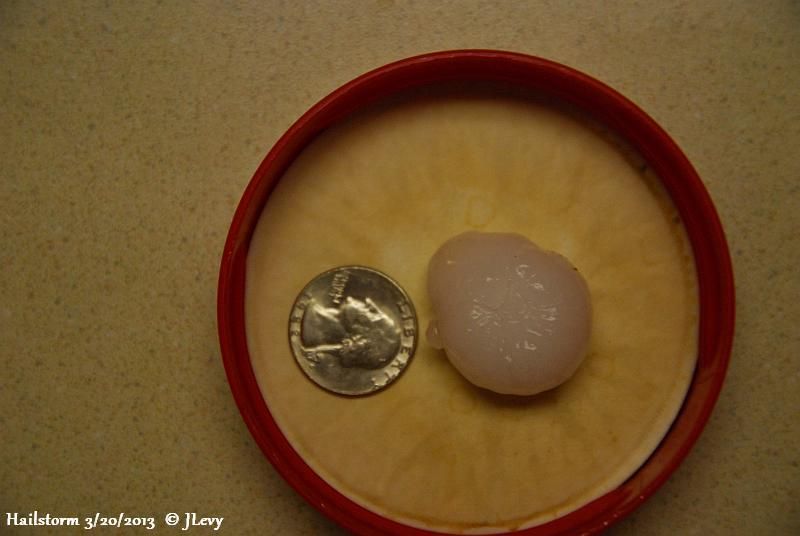
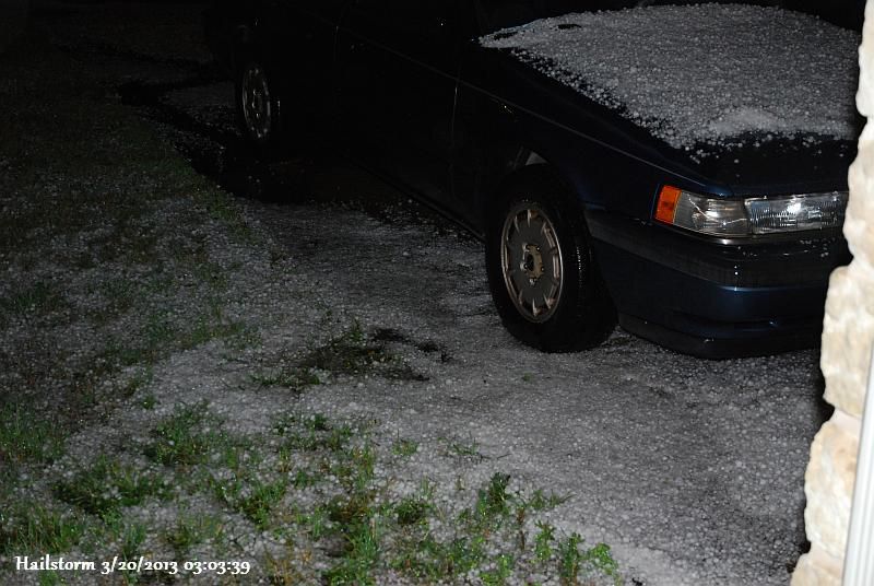
Bigger than quarter size hail North Austin near P'ville.

Image

Image
0 likes   

weatherdude1108
Category 5
Category 5
Posts: 4228
Joined: Tue Dec 13, 2011 1:04 pm
Location: Northwest Austin/Cedar Park, TX

#136 Postby weatherdude1108 » Wed Mar 20, 2013 6:02 am

:uarrow:
I got marble-size in south Cedar Park (measured it). Woke me up!
No vegetation was stripped that I saw, like four years ago with the ping pong hail we got and got a new roof out of.
0 likes   

User avatar
wxman57
Moderator-Pro Met
Moderator-Pro Met
Posts: 22978
Age: 67
Joined: Sat Jun 21, 2003 8:06 pm
Location: Houston, TX (southwest)

Re: Texas Spring 2013

#137 Postby wxman57 » Wed Mar 20, 2013 7:43 am

Winter is now officially OVER! :woo: :clap:
0 likes   

SaskatchewanScreamer

Re: Texas Spring 2013

#138 Postby SaskatchewanScreamer » Wed Mar 20, 2013 8:21 am

wxman57 wrote:Winter is now officially OVER! :woo: :clap:


:roflmao: :roflmao: :roflmao: :roflmao: :roflmao:


Image

Image
Last edited by SaskatchewanScreamer on Wed Mar 20, 2013 8:57 am, edited 1 time in total.
0 likes   

weatherdude1108
Category 5
Category 5
Posts: 4228
Joined: Tue Dec 13, 2011 1:04 pm
Location: Northwest Austin/Cedar Park, TX

#139 Postby weatherdude1108 » Wed Mar 20, 2013 8:34 am

We got 0.24-inch in electronic gauge, and 0.4-inch in analog gauge. Not enough. :roll: Hail has water, but rain is better! :wink:
0 likes   

User avatar
wxman57
Moderator-Pro Met
Moderator-Pro Met
Posts: 22978
Age: 67
Joined: Sat Jun 21, 2003 8:06 pm
Location: Houston, TX (southwest)

Re: Texas Spring 2013

#140 Postby wxman57 » Wed Mar 20, 2013 8:58 am

Maybe you'll have spring by the time summer starts, SaskatchewanScreamer. :cry:

Image
0 likes   


Return to “USA & Caribbean Weather”

Who is online

Users browsing this forum: Google Adsense [Bot] and 18 guests