Texas Winter 2012-2013
Moderator: S2k Moderators
Forum rules
 The posts in this forum are NOT official forecast and should not be used as such. They are just the opinion of the poster and may or may not be backed by sound meteorological data. They are NOT endorsed by any professional institution or STORM2K.

The posts in this forum are NOT official forecast and should not be used as such. They are just the opinion of the poster and may or may not be backed by sound meteorological data. They are NOT endorsed by any professional institution or STORM2K.
-
ThunderSleetDreams

- S2K Supporter

- Posts: 1510
- Age: 43
- Joined: Tue Dec 20, 2011 4:42 pm
- Location: S of Weimar, TX
Re: Texas Winter 2012-2013
Yeah, I was about to say... the CFSv2 has been pretty spot on for October, November and December. At least it has for us in SE Texas.
0 likes
#NeverSummer
I hibernate when it gets above 75 degrees!
I hibernate when it gets above 75 degrees!
-
cheezyWXguy

- Category 5

- Posts: 6282
- Joined: Mon Feb 13, 2006 12:29 am
- Location: Dallas, TX
Cyclenall, I'm not sure I understand you. I dont intend disrespect, but I dont understand why it bothers you that people from Texas are so hungry for cold and snow, when you reflect the exact same attitude towards warmth. And seeing as you live so far away from us, I'm not even sure why you care so much what our weather is like. If it bothers you, you dont have to read it.
0 likes

It's not just the CFSv2, brett anderson at accuwx showed his interpretation of the Euro weeklies and it's pretty cold too in January for North America while the rest of the world warms up.
0 likes
The above post and any post by Ntxw is NOT an official forecast and should not be used as such. It is just the opinion of the poster and may or may not be backed by sound meteorological data. It is NOT endorsed by any professional institution including Storm2k. For official information, please refer to NWS products.
Help support Storm2K!

Re: Texas Winter 2012-2013
orangeblood wrote:I'd say. I would bet my life savings that this upcoming January will not be record cold for most of North America, this is coming from pro-cold lovers who can't stand what the atmosphere has been giving us for the past couple years. The CFSv2 has been wrong for this month showing very cold conditions but instead above normal was served (to my delight). Now it wants us to buy the January cold story like December was suppose to be. I don't follow the CFS because of this. Just keep those 1050+ mb highs away and we're good
.
Sorry but your comment about the CFSv2 for this month is flat out false....it actually did pretty well forecasting temps for December back in November. Here is a map showing the forecast from a month ago:
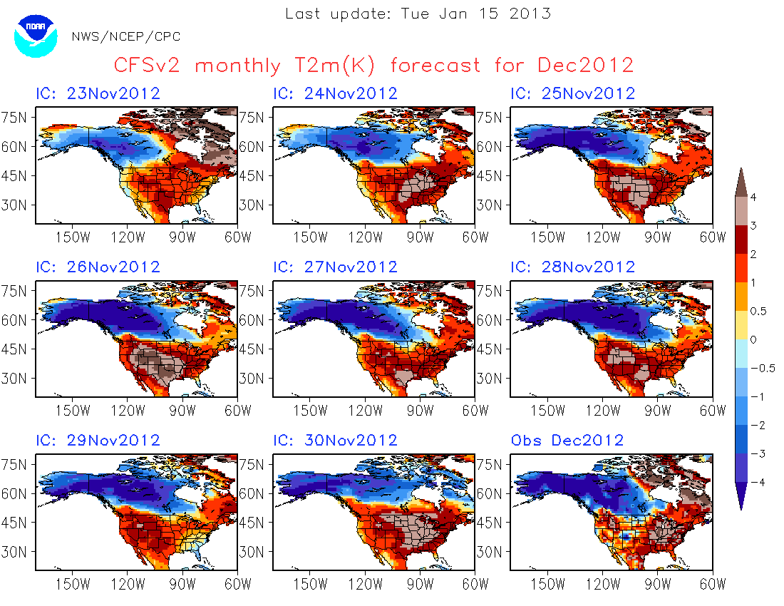
With 10 more days to go in December at least the north/central US and western US may not be as warm as it forecasted with a colder pattern setting in over the next few days.
An area where it was not correct is the FL Peninsula, instead much warmer than average temps have rule this month.
edit: But overall it did pretty well.
0 likes

Re: Texas Winter 2012-2013
Just not buying it what some of models are showing right now. I think the cold will come in faster (which they usually have trouble with) and I still feel like they will come around to what they were showing a few days ago.
There will be snow on the ground to our north, lots of cold air diving down...it just feels right.
There will be snow on the ground to our north, lots of cold air diving down...it just feels right.
0 likes
Re: Texas Winter 2012-2013
iorange55 wrote:Just not buying it what some of models are showing right now. I think the cold will come in faster (which they usually have trouble with) and I still feel like they will come around to what they were showing a few days ago.
There will be snow on the ground to our north, lots of cold air diving down...it just feels right.
A 1040+ high along the US/Canadian border is not going to stall a cold front like the GFS is showing, especially not in the plains.
0 likes
The above post and any post by Ntxw is NOT an official forecast and should not be used as such. It is just the opinion of the poster and may or may not be backed by sound meteorological data. It is NOT endorsed by any professional institution including Storm2k. For official information, please refer to NWS products.
Help support Storm2K!
Help support Storm2K!
-
Portastorm

- Storm2k Moderator

- Posts: 9955
- Age: 63
- Joined: Fri Jul 11, 2003 9:16 am
- Location: Round Rock, TX
- Contact:
Re: Texas Winter 2012-2013
Yep. You may recall that is exactly what wxman57 said yesterday. He talked about how he didn't believe the GFS holding up the cold air and how that was a common error with the model.
0 likes
Any forecasts under my name are to be taken with a grain of salt. Get your best forecasts from the National Weather Service and National Hurricane Center.
Speaking of heat a little off topic. I think there's a misconception about wxman57 on here! He doesn't like cold, but he does like snow! You guys should go back to some of the older threads like back in December 2009, if there's a good chance of it in Houston he will be the first to jump on it. In short, our resident heat miser has an inner kid that most of us usually do not see  most people don't remember this!
0 likes
The above post and any post by Ntxw is NOT an official forecast and should not be used as such. It is just the opinion of the poster and may or may not be backed by sound meteorological data. It is NOT endorsed by any professional institution including Storm2k. For official information, please refer to NWS products.
Help support Storm2K!
Help support Storm2K!
-
Rgv20

- S2K Supporter
- Posts: 2466
- Age: 39
- Joined: Wed Jan 05, 2011 5:42 pm
- Location: Edinburg/McAllen Tx
Anybody want to trade my weather for Christmas?? A forecast high of 87 is just a cruel joke! 
''CHRISTMAS DAY DAWNS WARM AND SOUPY. HOW THE AFTERNOON SHAPES UP
WILL DEPEND ON TIMING OF THE NEXT FRONT AND ITS PRE-FRONTAL WARM
SPIKE. GFS CONTINUES TO ADVERTISE THE SPIKE AS WIND SHIFT TO THE
WEST OR NORTHWEST WITH INCREASING AFTERNOON SUNSHINE. THE ECMWF
CONTINUES WITH MORE SOUTHERLY WINDS BUT ALSO POKES NOSE OF VERY
WARM...20C...850MB TEMPERATURES INTO THE VALLEY. SIMILAR TO
TODAY...WEST/SOUTHWEST FLOW OFF THE DECK WOULD COMPRESSIONALLY
HEAT THOSE VALUES TOWARD 90 AND WOULD NOT SURPRISE ME TO SEE IT
HAPPEN. FOR NOW...HAVE LEVELED AT 87 INLAND...KEEPING LOWER
TEMPERATURES NEAR THE COOLER GULF.
BOTTOM LINE? GREEN CHRISTMAS! NO JACKET...OR SWEATER...REQUIRED.
FINALLY...THE DAY AFTER CHRISTMAS IS A LITTLE UNCERTAIN GIVEN
TIMING OF FRONT. WITH PROGRESSIVE FLOW PREFER TO KEEP THINGS
MOVING AND LEANING TOWARD GFS BUT WITH A MORE RAPID TEMPERATURE
FALL/WIND SURGE AFTER MIDNIGHT. THE DAYTIME SHOULD FEATURE ANOTHER
BLUSTERY DAY WITH A LITTLE MORE CHILL DESPITE SUNSHINE AS AIR MASS
WILL HAVE A TOUCH OF WESTERN CANADA WITH IT. FIRE WEATHER CONCERNS
WILL RATCHET UP AGAIN AS WELL.''
0 likes
The following post is NOT an official forecast and should not be used as such. It is just the opinion of the poster and may or may not be backed by sound meteorological data. It is NOT endorsed by any professional institution including storm2k.org For Official Information please refer to the NHC and NWS products.
-
Portastorm
- Storm2k Moderator
- Posts: 9955
- Age: 63
- Joined: Fri Jul 11, 2003 9:16 am
- Location: Round Rock, TX
- Contact:
Re:
NDG wrote:That it will get cold in TX after Christmas is most certainly likely, that it will snow across north central and NE TX it is still up in the air, IMO.
It will depend where the trough deepens and ejects in a NE direction.
At this point, my thoughts exactly. Well said NDG!
0 likes
Any forecasts under my name are to be taken with a grain of salt. Get your best forecasts from the National Weather Service and National Hurricane Center.

Re: Texas Winter 2012-2013
the 18Z GFS looks mighty chilly for Texas in a few days!
http://mag.ncep.noaa.gov/NCOMAGWEB/appc ... mageSize=M
http://mag.ncep.noaa.gov/NCOMAGWEB/appc ... mageSize=M
0 likes
Re: Texas Winter 2012-2013
ROCK wrote:the 18Z GFS looks mighty chilly for Texas in a few days!
http://mag.ncep.noaa.gov/NCOMAGWEB/appc ... mageSize=M
Can't hide anything from you ROCK
0 likes
The above post and any post by Ntxw is NOT an official forecast and should not be used as such. It is just the opinion of the poster and may or may not be backed by sound meteorological data. It is NOT endorsed by any professional institution including Storm2k. For official information, please refer to NWS products.
Help support Storm2K!
Help support Storm2K!
Re: Texas Winter 2012-2013
0 likes
Re: Texas Winter 2012-2013
Ntxw wrote:ROCK wrote:the 18Z GFS looks mighty chilly for Texas in a few days!
http://mag.ncep.noaa.gov/NCOMAGWEB/appc ... mageSize=M
Can't hide anything from you ROCK
I was looking for the source of this cold air after Xmas and it seems Artic in nature. With good snow pack to our north only slight modification...GFS does not due well with shallow air masses from my understanding. Its good though sniffing out a pattern change in the long run. As the event draws near I turn to the NAM..but thats just me...
0 likes
-
Portastorm
- Storm2k Moderator
- Posts: 9955
- Age: 63
- Joined: Fri Jul 11, 2003 9:16 am
- Location: Round Rock, TX
- Contact:
Re: Texas Winter 2012-2013
Oh my gosh ... break out the good whiskey and glasses, ROCK is here!!
0 likes
Any forecasts under my name are to be taken with a grain of salt. Get your best forecasts from the National Weather Service and National Hurricane Center.
-
Comanche

- Category 1

- Posts: 381
- Age: 54
- Joined: Wed Jul 06, 2005 9:33 am
- Location: Clear Lake City Texas
I have a question for all you weather lovers, a little off topic but certainly pertains to the general subject. I see a lot of private forecasts for energy, and the last couple of years has been let's say, very interesting as to the seasonal forecast methodology used. Winter 2010/2011 was La Nina and analogged to be warm throughout the south and some of the atlantic, which it was not at all. The driver was said to be the strato-warming and blocking pattern that over-rode the pacific influence, so most seasonal forecasts busted. Then last year, we again have La Nina and analogs to a warm winter in the south/mid atlantic, yet almost all forecasters called for a colder winter (like what transpired in the previous year), saying they expected a continuation of strato-warming and blocking. Fail again, analogs won last year, well analogs on steroids anyway.
So I am looking into drivers of the coldest winter on the books, the 1978/1979 brutal coast-to-coast winter:

I spent time today out of curiousity on what the drivers of that winter were, looked at PDO, PNA, AO, NAO and a very neutral ENSO (La Nada). NOTHING stands out at all. Very mild readings of all the signals, and spent some time in positive and negative readings.
I cannot figure out what the driver of that cold was. Can anyone here shed some light on this?
here are the sources I used:
AO ftp://ftp.cpc.ncep.noaa.gov/cwlinks/nor ... rent.ascii
NAO ftp://ftp.cpc.ncep.noaa.gov/cwlinks/nor ... rent.ascii
PNA ftp://ftp.cpc.ncep.noaa.gov/cwlinks/nor ... rent.ascii
PDO http://jisao.washington.edu/pdo/PDO.latest
ENSO http://ggweather.com/enso/oni.htm
So I am looking into drivers of the coldest winter on the books, the 1978/1979 brutal coast-to-coast winter:
I spent time today out of curiousity on what the drivers of that winter were, looked at PDO, PNA, AO, NAO and a very neutral ENSO (La Nada). NOTHING stands out at all. Very mild readings of all the signals, and spent some time in positive and negative readings.
I cannot figure out what the driver of that cold was. Can anyone here shed some light on this?
here are the sources I used:
AO ftp://ftp.cpc.ncep.noaa.gov/cwlinks/nor ... rent.ascii
NAO ftp://ftp.cpc.ncep.noaa.gov/cwlinks/nor ... rent.ascii
PNA ftp://ftp.cpc.ncep.noaa.gov/cwlinks/nor ... rent.ascii
PDO http://jisao.washington.edu/pdo/PDO.latest
ENSO http://ggweather.com/enso/oni.htm
0 likes
Re: Texas Winter 2012-2013
Portastorm wrote:Oh my gosh ... break out the good whiskey and glasses, ROCK is here!!
0 likes
Re:
Comanche wrote:I cannot figure out what the driver of that cold was. Can anyone here shed some light on this?
From what I know, you have to look at the AO and NAO. Regardless what ENSO is or any other factor, no -AO = No cold air to use below the Arctic Circle. 1976, 1977, 2002, 2009, 2010 are all years we regard as incredibly cold. They all had one thing in common, very negative AO, period. 2001, 2008, and last year were raging +AO's, so even with the +PNA all we got were slightly wet and mild. Stratwarm events are used to forecast one thing, the AO, that's what blocking is. The EPO and NAO are just extensions of the AO and the PNA essentially is an extension of the EPO, that's why you see them usually match each other.

Now one might ask, what makes the AO positive or negative? Above the arctic is usually a polar vortex in the stratosphere. This tightly wound wind controls the jet, when it is strong all the cold is bundled underneath and you have zonal flow around it (jet goes in an nice circle) =+AO. A stratwarm event changes the wind patterns up in the stratosphere and often moves the vortex south, and you no longer have a nice circle of jet winds, you have a disturbed jet that moves south with it, and that is where you see the ridges/troughs amplify to blocking = -AO.
Last edited by Ntxw on Wed Dec 19, 2012 6:38 pm, edited 2 times in total.
0 likes
The above post and any post by Ntxw is NOT an official forecast and should not be used as such. It is just the opinion of the poster and may or may not be backed by sound meteorological data. It is NOT endorsed by any professional institution including Storm2k. For official information, please refer to NWS products.
Help support Storm2K!
Help support Storm2K!
-
Tireman4

- S2K Supporter
- Posts: 5904
- Age: 60
- Joined: Fri Jun 30, 2006 1:08 pm
- Location: Humble, Texas
- Contact:
Re: Re:
Tireman4 wrote:wxman57 wrote:Tireman4 wrote:Meanwhile, we have hit 81 degrees at KIAH and the record for December 19 is...ding ding ding...81...lovely...just lovely....
Wow! Didn't realize the weather was so nice outside! We have no windows in operations. Another beautiful December day, though not as sunny as yesterday. Can't beat that.
And to think, even at a 7:30 pace yesterday, it was brutal. I swear the last 2 miles of my 7 mile run I was just holding on. I have been running for over 30 years and that was brutal. I will not start my run until 4:15 today. Any bets I will hurt? Sigh.
And just as I predicted, it hurt. It was, again, another brutal run. At least I was able to make it to the 7 mile mark at 53:12 (7:36 pace) before I fell down. Man oh man. I swigged a 32 oz Powerade. Great. Please bring that front. Please. I am now begging...
0 likes
Who is online
Users browsing this forum: No registered users and 181 guests