Texas Winter 2012-2013
Moderator: S2k Moderators
Forum rules
 The posts in this forum are NOT official forecast and should not be used as such. They are just the opinion of the poster and may or may not be backed by sound meteorological data. They are NOT endorsed by any professional institution or STORM2K.

The posts in this forum are NOT official forecast and should not be used as such. They are just the opinion of the poster and may or may not be backed by sound meteorological data. They are NOT endorsed by any professional institution or STORM2K.
-
GRAYSONCO.WX
- Category 1

- Posts: 450
- Joined: Thu Jan 06, 2011 4:29 pm
- Location: Denison, Texas
Re: Texas Winter 2012-2013
Any thoughts on the 12Z NAM? It appears to be pretty consistent with the past run or two.
0 likes
-
Portastorm

- Storm2k Moderator

- Posts: 9955
- Age: 63
- Joined: Fri Jul 11, 2003 9:16 am
- Location: Round Rock, TX
- Contact:
Re: Texas Winter 2012-2013
GRAYSONCO.WX wrote:Any thoughts on the 12Z NAM? It appears to be pretty consistent with the past run or two.
Actually, IMO, it appears to be a little less aggressive with the post front precip than previous runs. It does show a little bit of light snow/ice pellets in and around the DFW Metroplex and areas to the northwest for a few hours.
0 likes
Any forecasts under my name are to be taken with a grain of salt. Get your best forecasts from the National Weather Service and National Hurricane Center.
-
GRAYSONCO.WX
- Category 1
- Posts: 450
- Joined: Thu Jan 06, 2011 4:29 pm
- Location: Denison, Texas
Re: Texas Winter 2012-2013
Portastorm wrote:GRAYSONCO.WX wrote:Any thoughts on the 12Z NAM? It appears to be pretty consistent with the past run or two.
Actually, IMO, it appears to be a little less aggressive with the post front precip than previous runs. It does show a little bit of light snow/ice pellets in and around the DFW Metroplex and areas to the northwest for a few hours.
Interesting; thanks! I was mainly looking at the 500mb maps which appears to be fairly similar.
0 likes
-
Portastorm
- Storm2k Moderator
- Posts: 9955
- Age: 63
- Joined: Fri Jul 11, 2003 9:16 am
- Location: Round Rock, TX
- Contact:
Re: Texas Winter 2012-2013
I've never been one to act like Scrooge when it comes to the possibility of winter weather in Texas, but on this one ... I wouldn't count on anything, graysonco.wx. If it happens for you, consider it a pleasant surprise. If not, then you didn't expect anything. 
Until we start seeing more associated moisture in the post-frontal atmosphere, I'm just not all that confident about anyone's winter wx chances up north. It's going to be very light at best. JMO.
Until we start seeing more associated moisture in the post-frontal atmosphere, I'm just not all that confident about anyone's winter wx chances up north. It's going to be very light at best. JMO.
0 likes
Any forecasts under my name are to be taken with a grain of salt. Get your best forecasts from the National Weather Service and National Hurricane Center.

-
orangeblood
- S2K Supporter

- Posts: 3895
- Joined: Tue Dec 15, 2009 6:14 pm
- Location: Fort Worth, TX
Re: Texas Winter 2012-2013
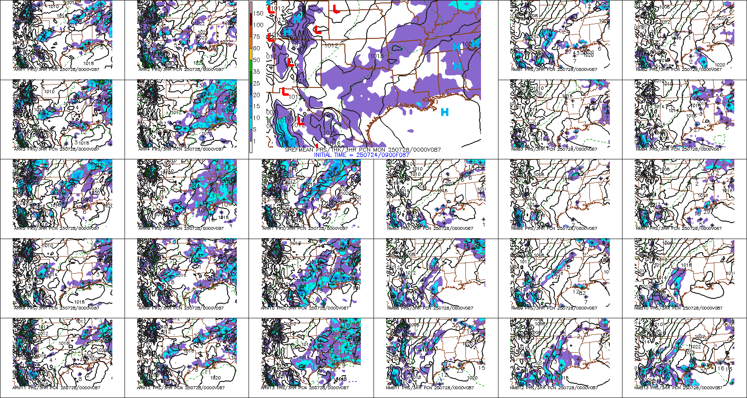
SREF members are much more aggressive with post-frontal precip across North Texas on Monday morning....showing probabilities for more than 1" of snow of greater than 20% in some parts of north texas. If this trough digs further south than currently forecast, look for these probabilities to increase as we get closer to this event.
The following post is NOT an official forecast and should not be used as such. It is just the opinion of the poster and may or may not be backed by sound meteorological data. It is NOT endorsed by any professional institution including storm2k.org. For official information, please refer to NWS products.
The following post is NOT an official forecast and should not be used as such. It is just the opinion of the poster and may or may not be backed by sound meteorological data. It is NOT endorsed by any professional institution including storm2k.org. For official information, please refer to NWS products.
0 likes
-
GRAYSONCO.WX
- Category 1
- Posts: 450
- Joined: Thu Jan 06, 2011 4:29 pm
- Location: Denison, Texas
Re: Texas Winter 2012-2013
orangeblood wrote:SREF members are much more aggressive with post-frontal precip across North Texas on Monday morning....showing probabilities for more than 1" of snow of greater than 20% in some parts of north texas. If this trough digs further south than currently forecast, look for these probabilities to increase as we get closer to this event.
The following post is NOT an official forecast and should not be used as such. It is just the opinion of the poster and may or may not be backed by sound meteorological data. It is NOT endorsed by any professional institution including storm2k.org. For official information, please refer to NWS products.
Interesting! Can you post an image or link?
0 likes
-
orangeblood
- S2K Supporter
- Posts: 3895
- Joined: Tue Dec 15, 2009 6:14 pm
- Location: Fort Worth, TX
Re: Texas Winter 2012-2013
GRAYSONCO.WX wrote:orangeblood wrote:SREF members are much more aggressive with post-frontal precip across North Texas on Monday morning....showing probabilities for more than 1" of snow of greater than 20% in some parts of north texas. If this trough digs further south than currently forecast, look for these probabilities to increase as we get closer to this event.
The following post is NOT an official forecast and should not be used as such. It is just the opinion of the poster and may or may not be backed by sound meteorological data. It is NOT endorsed by any professional institution including storm2k.org. For official information, please refer to NWS products.
Interesting! Can you post an image or link?
here you go...notice how some of the members show quite a bit of wrap around precip as the trough moves through
0 likes

Ukmet seems to be the most amplified and vigorous with moisture this morning. Takes on a more neutral tilt vs positive which is better for some moisture return. A blend of it and the euro's qpf regeneration would probably be ideal for us.

0 likes
The above post and any post by Ntxw is NOT an official forecast and should not be used as such. It is just the opinion of the poster and may or may not be backed by sound meteorological data. It is NOT endorsed by any professional institution including Storm2k. For official information, please refer to NWS products.
Help support Storm2K!
-
GRAYSONCO.WX
- Category 1
- Posts: 450
- Joined: Thu Jan 06, 2011 4:29 pm
- Location: Denison, Texas
Re: Texas Winter 2012-2013
orangeblood wrote:GRAYSONCO.WX wrote:orangeblood wrote:SREF members are much more aggressive with post-frontal precip across North Texas on Monday morning....showing probabilities for more than 1" of snow of greater than 20% in some parts of north texas. If this trough digs further south than currently forecast, look for these probabilities to increase as we get closer to this event.
The following post is NOT an official forecast and should not be used as such. It is just the opinion of the poster and may or may not be backed by sound meteorological data. It is NOT endorsed by any professional institution including storm2k.org. For official information, please refer to NWS products.
Interesting! Can you post an image or link?
here you go...notice how some of the members show quite a bit of wrap around precip as the trough moves through
Thank you! Yes, some of the members do show some good wrap around moisture! Let's hope this trend continues. Btw, has this system been sampled yet?
0 likes
-
GRAYSONCO.WX
- Category 1
- Posts: 450
- Joined: Thu Jan 06, 2011 4:29 pm
- Location: Denison, Texas
Re:
Ntxw wrote:Ukmet seems to be the most amplified and vigorous with moisture this morning. Takes on a more neutral tilt vs positive which is better for some moisture return. A blend of it and the euro's qpf regeneration would probably be ideal for us.
Good, good! I'm ready for the 12Z ECMWF
0 likes
-
TeamPlayersBlue

- Category 5

- Posts: 3533
- Joined: Tue Feb 02, 2010 1:44 am
- Location: Denver/Applewood, CO
Hate to be a debbie downer but i think DFW sees some flakes with this system, maybe a dusting at best. The moisture just doesnt really seem to be there for a long period of time
0 likes
Personal Forecast Disclaimer:
The posts in this forum are NOT official forecast and should not be used as such. They are just the opinion of the poster and may or may not be backed by sound meteorological data. They are NOT endorsed by any professional institution or storm2k.org. For official information, please refer to the NHC and NWS products.
The posts in this forum are NOT official forecast and should not be used as such. They are just the opinion of the poster and may or may not be backed by sound meteorological data. They are NOT endorsed by any professional institution or storm2k.org. For official information, please refer to the NHC and NWS products.

Re: Texas Winter 2012-2013
TeamPlayersBlue wrote:Hate to be a debbie downer but i think DFW sees some flakes with this system, maybe a dusting at best. The moisture just doesnt really seem to be there for a long period of time
I don't think that makes you a debbie downer! It just makes you realistic. Even if we just see a few flakes, that would still be a very nice surprise. Everything after that would just be a bonus.
0 likes
Yeah everything is a bonus. Just seeing flurries at least matches last season  . Wasn't even expecting more than a front to knock temps near average not long ago.
0 likes
The above post and any post by Ntxw is NOT an official forecast and should not be used as such. It is just the opinion of the poster and may or may not be backed by sound meteorological data. It is NOT endorsed by any professional institution including Storm2k. For official information, please refer to NWS products.
Help support Storm2K!
Help support Storm2K!

-
CaptinCrunch

- S2K Supporter
- Posts: 8784
- Age: 58
- Joined: Mon Nov 03, 2003 4:33 pm
- Location: Kennedale, TX (Tarrant Co.)
Re:
Ntxw wrote:Yeah everything is a bonus. Just seeing flurries at least matches last season
When it's been 85 degrees for the first 4 days December, any type of winter precip with this front is a Bonus, Surprise, Gift, or anything else you can call it.

0 likes
-
gboudx

- S2K Supporter
- Posts: 4090
- Joined: Thu Sep 04, 2003 1:39 pm
- Location: Rockwall, Tx but from Harvey, La
Re: Re:
CaptinCrunch wrote:Ntxw wrote:Yeah everything is a bonus. Just seeing flurries at least matches last season
When it's been 85 degrees for the first 4 days December, any type of winter precip with this front is a Bonus, Surprise, Gift, or anything else you can call it.
Shoot I'll be less picky, any type of precip is a bonus. My favorite mountain bike trail is so dusty, going into turns could mean tires losing grip and into a tree. Yes, this has happened to me. Twice in the past month.
0 likes
Re: Texas Winter 2012-2013
My 7 day forecast changed slightly.
Monday Night: A 40 percent chance of rain. Partly cloudy, with a low around 29.
Getting almost cold enough for snow!!
Monday Night: A 40 percent chance of rain. Partly cloudy, with a low around 29.
Getting almost cold enough for snow!!
0 likes
-
weatherdude1108
- Category 5
- Posts: 4228
- Joined: Tue Dec 13, 2011 1:04 pm
- Location: Northwest Austin/Cedar Park, TX
NATIONAL WEATHER SERVICE AUSTIN/SAN ANTONIO TX
338 PM CST FRI DEC 7 2012
.DISCUSSION...
THE UPPER LEVEL PATTERN HAS SHIFTED TO THE EAST WITH THE FLOW
BECOMING ZONAL ALOFT. AT THE SFC HIGH PRESSURE IS CENTERED OVER THE
GULF AND THERE IS LOW PRESSURE CENTERED ALONG THE RED RIVER IN
SOUTHEASTERN OK. THIS HAS THE SFC WINDS BLOWING MAINLY FROM THE
SOUTH. THE VAD WIND PROFILES FROM AREA RADARS SHOW DEEPER LAYER
WINDS ALSO FROM THE SOUTH UP TO ABOUT 5 KFT. THIS GENERAL PATTERN
WILL REMAIN IN PLACE FOR THE WEEKEND. LOOK FOR SAT AND SUN TO BE A
REPEAT OF THE LAST COUPLE OF DAYS WITH LATE NIGHT/EARLY MORNING
FOG AND POSSIBLE DRIZZLE...THEN GRADUAL CLEARING DURING THE
AFTERNOON. THE BIG CHANGE WILL COME LATE SUN AND MON. AN UPPER
LEVEL TROUGH WILL MOVE OUT OF THE ROCKIES INTO THE SOUTHERN PLAINS
AND BRING A STRONG COLD FRONT THROUGH TEXAS. THE FRONT WILL MOVE
THROUGH SUN NIGHT/MON MORNING. THIS WILL BRING A CHANCE FOR
SHOWERS AND THUNDERSTORMS SUN AFTERNOON THROUGH MON MORNING. BEST
CHANCE FOR PRECIP WILL OVERNIGHT. BEHIND THE FRONT WILL BE THE
COLDEST AIR OF THE SEASON SO FAR. HIGH TEMPS MON WILL BE AS MUCH
AS 30 DEGREES COLDER THAN HIGHS ON SUN. TUE MORNING WILL BRING
FREEZING TEMPS TO MOST OF THE CWA WITH ONLY THE SOUTHWESTERN
PORTION OF THE AREA STAYING ABOVE THAT MARK. MOST OF THE AREA WILL
HAVE LOWS IN THE 20S. FOR THE MIDDLE PART OF NEXT WEEK...THE UPPER
TROUGH WILL MOVE OFF THE EAST AND COOL TEMPS WILL STICK AROUND
WITH TEMPS BELOW NORMAL UNTIL THU. NO OTHER CHANCES FOR PRECIP FOR
THE REST OF THE FORECAST.
0 likes
The preceding post is NOT an official forecast, and should not be used as such. It is only the opinion of the poster and may or may not be backed by sound meteorological data. It is NOT endorsed by any professional institution including storm2k.org. For Official Information please refer to the NHC and NWS products.
Who is online
Users browsing this forum: No registered users and 140 guests