Texas Winter 2012-2013
Moderator: S2k Moderators
Forum rules
 The posts in this forum are NOT official forecast and should not be used as such. They are just the opinion of the poster and may or may not be backed by sound meteorological data. They are NOT endorsed by any professional institution or STORM2K.

The posts in this forum are NOT official forecast and should not be used as such. They are just the opinion of the poster and may or may not be backed by sound meteorological data. They are NOT endorsed by any professional institution or STORM2K.
-
TeamPlayersBlue

- Category 5

- Posts: 3533
- Joined: Tue Feb 02, 2010 1:44 am
- Location: Denver/Applewood, CO
Wher can we get an update on the MJO? Any help there for us?
0 likes
Personal Forecast Disclaimer:
The posts in this forum are NOT official forecast and should not be used as such. They are just the opinion of the poster and may or may not be backed by sound meteorological data. They are NOT endorsed by any professional institution or storm2k.org. For official information, please refer to the NHC and NWS products.
The posts in this forum are NOT official forecast and should not be used as such. They are just the opinion of the poster and may or may not be backed by sound meteorological data. They are NOT endorsed by any professional institution or storm2k.org. For official information, please refer to the NHC and NWS products.

Re:
TeamPlayersBlue wrote:Wher can we get an update on the MJO? Any help there for us?
MJO is incoherent at this time as is the case without El Nino or La Nina. The drivers appears to be the global wind oscillations, which is currently in high amplitude mode (bigger ridges and troughs aka blocking).
MJO forecasts here
http://www.cpc.ncep.noaa.gov/products/p ... /mjo.shtml
0 likes
The above post and any post by Ntxw is NOT an official forecast and should not be used as such. It is just the opinion of the poster and may or may not be backed by sound meteorological data. It is NOT endorsed by any professional institution including Storm2k. For official information, please refer to NWS products.
Help support Storm2K!
-
TeamPlayersBlue
- Category 5
- Posts: 3533
- Joined: Tue Feb 02, 2010 1:44 am
- Location: Denver/Applewood, CO
Thank you very much sir!
80F here, my run was exhausting.
80F here, my run was exhausting.
0 likes
Personal Forecast Disclaimer:
The posts in this forum are NOT official forecast and should not be used as such. They are just the opinion of the poster and may or may not be backed by sound meteorological data. They are NOT endorsed by any professional institution or storm2k.org. For official information, please refer to the NHC and NWS products.
The posts in this forum are NOT official forecast and should not be used as such. They are just the opinion of the poster and may or may not be backed by sound meteorological data. They are NOT endorsed by any professional institution or storm2k.org. For official information, please refer to the NHC and NWS products.
-
Portastorm

- Storm2k Moderator

- Posts: 9955
- Age: 63
- Joined: Fri Jul 11, 2003 9:16 am
- Location: Round Rock, TX
- Contact:
Re: Re:
Ntxw wrote:TeamPlayersBlue wrote:Wher can we get an update on the MJO? Any help there for us?
MJO is incoherent at this time as is the case without El Nino or La Nina. The drivers appears to be the global wind oscillations, which is currently in high amplitude mode (bigger ridges and troughs aka blocking).
MJO forecasts here
http://www.cpc.ncep.noaa.gov/products/p ... /mjo.shtml
The strength of the MJO pulse matters and the stronger the pulse, the more likely one sees pronounced impacts on given areas per the eight cycles. And as Ntxw said, even though the MJO is in favorable cycles (or I believe they may be called octants) for rainfall for us, the strength of the pulse is nominal.
0 likes
Any forecasts under my name are to be taken with a grain of salt. Get your best forecasts from the National Weather Service and National Hurricane Center.
-
weatherguy425
- Tropical Storm

- Posts: 180
- Joined: Sun Aug 16, 2009 1:06 pm
- Location: Houston, TX > Lubbock, TX > Savannah, GA
- Contact:
Re: Texas Winter 2012-2013
Well it is a little encouraging that the ECMWF has trended ever-so-slightly deeper with Sunday/Monday's system. However, ensembles of both major globals aren't all that supportive of a closed system. Add to this the fact that today's runs have already begun backing off on a positive PNA slightly, and I'm just not sure when we will see our first significant winter system on the South Plains.
0 likes
Latest GFS is still supporting a powerful storm to effect the southern plains with heavy rain on the warm end and frozen precipitation on the nw side of the system one week from today.
0 likes
The above post and any post by Ntxw is NOT an official forecast and should not be used as such. It is just the opinion of the poster and may or may not be backed by sound meteorological data. It is NOT endorsed by any professional institution including Storm2k. For official information, please refer to NWS products.
Help support Storm2K!
Help support Storm2K!
-
weatherdude1108
- Category 5
- Posts: 4228
- Joined: Tue Dec 13, 2011 1:04 pm
- Location: Northwest Austin/Cedar Park, TX
This is more encouraging from Bob Rose than his blog last Friday! 
http://www.lcra.org/water/conditions/we ... olumn.html
http://www.lcra.org/water/conditions/we ... olumn.html
0 likes
The preceding post is NOT an official forecast, and should not be used as such. It is only the opinion of the poster and may or may not be backed by sound meteorological data. It is NOT endorsed by any professional institution including storm2k.org. For Official Information please refer to the NHC and NWS products.
-
Rgv20

- S2K Supporter

- Posts: 2466
- Age: 39
- Joined: Wed Jan 05, 2011 5:42 pm
- Location: Edinburg/McAllen Tx
0zGFS continues to forecast some mighty cold air in Western Canada....It is still ways off in the long range tho.
0zGFS 850mb Temperature Anomalies forecast valid for Sunday 12/16/12.
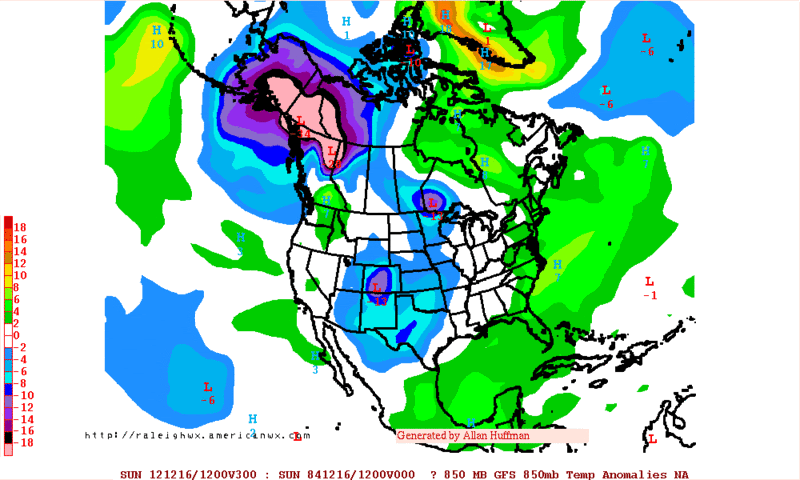
0zGFS 850mb Temperature Anomalies forecast valid for Sunday 12/16/12.
0 likes
The following post is NOT an official forecast and should not be used as such. It is just the opinion of the poster and may or may not be backed by sound meteorological data. It is NOT endorsed by any professional institution including storm2k.org For Official Information please refer to the NHC and NWS products.
-
gboudx

- S2K Supporter
- Posts: 4090
- Joined: Thu Sep 04, 2003 1:39 pm
- Location: Rockwall, Tx but from Harvey, La
Relevant "Winter" part of jeff's email:
Long Range:
After weeks warmth…some record…across much of the nation, the upper air pattern looks to finally break down from its fast progressive west to east flow to more amplification of a ridge of high pressure off the western US coast. This newly developing upper air pattern will shut off the parade of storm system into the W coast and direct the development of a downstream trough over the western US and plains. Cold air which has been bottled up in NW Canada will be unleashed into the US by this weekend and spread rapidly down the plains and into TX by early next week. Long range global models are having a hard time resolving the timing of this strong old front and how cold the post frontal air mass might be. Given past history with shallow cold air masses, will take the faster and colder solutions and expect a strong front to push into SE TX sometime early Monday and sweep off the coast during the day. Highs will be prior to the front with rapidly falling temperatures behind the boundary into the 40’s and 50’s under strong cold air advection. Some degree of energy does look to lag back in the base of the trough over the SW US post front which may keep clouds around behind the front and temper the temperature rise during the day. Still plenty of time to fine tune the affects of this pattern change and eventual air mass change…but finally some longer lasting cold air looks to be headed this way.
0 likes
-
Portastorm
- Storm2k Moderator
- Posts: 9955
- Age: 63
- Joined: Fri Jul 11, 2003 9:16 am
- Location: Round Rock, TX
- Contact:
Re: Texas Winter 2012-2013
Interesting differences between the operational runs of 0z GFS and 0z Euro for next week's front.

Uploaded with ImageShack.us

Uploaded with ImageShack.us

Uploaded with ImageShack.us

Uploaded with ImageShack.us
0 likes
Any forecasts under my name are to be taken with a grain of salt. Get your best forecasts from the National Weather Service and National Hurricane Center.

Re: Texas Winter 2012-2013
All in all...things are looking up! Colder weather is a safe bet next week, and rain chances appear to be decent. It doesn't look like (right now) North Texas will get any wintry precip fun this time, but hopefully this is a sign of things to come!
I'm just glad I'll be able to actually enjoy some hot chocolate next week.
I'm just glad I'll be able to actually enjoy some hot chocolate next week.
0 likes
-
orangeblood
- S2K Supporter
- Posts: 3895
- Joined: Tue Dec 15, 2009 6:14 pm
- Location: Fort Worth, TX
Re: Texas Winter 2012-2013
With the NAO forecast to tank, you would think this southern plains storm has the potential to take more of a southerly route across the country. Rather then the Oklahoma to Detroit route that the EC shows.
0 likes
-
vbhoutex

- Storm2k Executive

- Posts: 29150
- Age: 74
- Joined: Wed Oct 09, 2002 11:31 pm
- Location: Cypress, TX
- Contact:
Re: Texas Winter 2012-2013
Portastorm wrote:Interesting differences between the operational runs of 0z GFS and 0z Euro for next week's front.
http://img843.imageshack.us/img843/2622/00zgfs500mbhghtna168.gif
http://img163.imageshack.us/img163/9224/00zeuro500mbhghtna168.gif
I am much more inclined to believe the first map considering lack of same type of progression as the second one so far this year. Also expect modification at all levels since there is a lack of snow cover all the way to the Canadian border or at least Northern tier of states.
0 likes
Skywarn, C.E.R.T.
Please click below to donate to STORM2K to help with the expenses of keeping the site going:

Please click below to donate to STORM2K to help with the expenses of keeping the site going:
-
weatherdude1108
- Category 5
- Posts: 4228
- Joined: Tue Dec 13, 2011 1:04 pm
- Location: Northwest Austin/Cedar Park, TX
-
Portastorm
- Storm2k Moderator
- Posts: 9955
- Age: 63
- Joined: Fri Jul 11, 2003 9:16 am
- Location: Round Rock, TX
- Contact:
Re: Texas Winter 2012-2013
vbhoutex wrote:Portastorm wrote:Interesting differences between the operational runs of 0z GFS and 0z Euro for next week's front.
http://img843.imageshack.us/img843/2622/00zgfs500mbhghtna168.gif
http://img163.imageshack.us/img163/9224/00zeuro500mbhghtna168.gif
I am much more inclined to believe the first map considering lack of same type of progression as the second one so far this year. Also expect modification at all levels since there is a lack of snow cover all the way to the Canadian border or at least Northern tier of states.
True but this system should be laying down a fair spread of snowcover to the north and northwest of the state. That *could* temper significant moderation.
Highs in the 40s for North Texas and 50s for south central Texas in a week is a distinct possibility and far from a reach based on guidance at the moment.
0 likes
Any forecasts under my name are to be taken with a grain of salt. Get your best forecasts from the National Weather Service and National Hurricane Center.
-
CaptinCrunch

- S2K Supporter
- Posts: 8784
- Age: 58
- Joined: Mon Nov 03, 2003 4:33 pm
- Location: Kennedale, TX (Tarrant Co.)
Re: Texas Winter 2012-2013
This morning AFD from NWS FTW
Hopfully this is the pattern we see through early March. As much as we all hope for some winter weather I'm just hoping for any type, we need the rain so bad as the drought has returned thanks to the driest Sept-Nov on record and the warmest November on record. I think this ENSO neutral will transition to a El Nino pattern before spring.
EXTENDED GUIDANCE IS GENERALLY CONVERGING ON A SOLUTION OFFERED
BY THE GFS THE LAST TWO DAYS. IT APPEARS A PIECE OF ENERGY WILL
DIG INTO THE DESERT SOUTHWEST AND HELP SHARPEN THE UPPER TROUGH BY
SUNDAY. THIS WILL ALLOW A COLD CANADIAN AIRMASS TO SPILL SOUTH
INTO THE PLAINS...WITH THE FRONT LIKELY ARRIVING HERE EARLY
MONDAY. THE GFS TIMING STILL LOOKS TOO SLOW...AND WE CONTINUE TO
PREFER THE FASTER ECMWF. WITH THE UPPER LEVEL ENERGY DIGGING AND
HANGING BACK...THIS INCREASES OUR RAIN CHANCES SUNDAY NIGHT AND
MONDAY AS THIS PATTERN WOULD CREATE GOOD ISENTROPIC LIFT. WILL
KEEPS POPS AT 20-30 PERCENT FOR NOW...AND ADDITIONAL CONSISTENCY
IN MODEL RUNS WILL ADD MORE CONFIDENCE FOR SOME BADLY NEEDED
RAINFALL. RIGHT NOW THE AIRMASS DOES NOT LOOK COLD ENOUGH FOR ANY
WINTER PRECIP AS FAR SOUTH AS OUR CWA. RAIN SHOULD END BEFORE THE
COLUMN COOLS BELOW FREEZING. HIGHS MONDAY WILL BE IN THE MORNING
AND WILL FALL THROUGH THE DAY...SO THE FORECAST OF HIGHS IN THE
50S ARE A BIT MISLEADING. LOWS MONDAY NIGHT SHOULD BE NEAR
FREEZING. HIGHS TUESDAY SHOULD STAY IN THE 40S DESPITE CLEARING
SKIES...AND NEXT TUESDAY NIGHT MAY FEATURE TEMPS IN THE 20S.
Hopfully this is the pattern we see through early March. As much as we all hope for some winter weather I'm just hoping for any type, we need the rain so bad as the drought has returned thanks to the driest Sept-Nov on record and the warmest November on record. I think this ENSO neutral will transition to a El Nino pattern before spring.
0 likes
-
weatherguy425
- Tropical Storm
- Posts: 180
- Joined: Sun Aug 16, 2009 1:06 pm
- Location: Houston, TX > Lubbock, TX > Savannah, GA
- Contact:
Re: Texas Winter 2012-2013
The track of this potentially closed low is going to be vital for my Lubbock location. Northern track would likely dry slot us, while a southern track could give my area a decent snow and severe weather for eastern Texas. Thoughts? Liking the 00z ECMWF , hopefully it keeps it up.
0 likes
-
Portastorm
- Storm2k Moderator
- Posts: 9955
- Age: 63
- Joined: Fri Jul 11, 2003 9:16 am
- Location: Round Rock, TX
- Contact:
Re: Texas Winter 2012-2013
weatherguy425 wrote:The track of this potentially closed low is going to be vital for my Lubbock location. Northern track would likely dry slot us, while a southern track could give my area a decent snow and severe weather for eastern Texas. Thoughts? Liking the 00z ECMWF , hopefully it keeps it up.
For your sake (and for my Tech freshman son's sake), I'd like to see y'all get some wintry weather. But I'm kinda in agreement with vbhoutex in that we haven't seen energy dig that far south this fall. What the 0z Euro is showing would be unusual (at least for this year). The trend has been for the vorticity in these systems to stay on a track north of Texas. In this case, a "Panhandle Hooker" may be in the works but that still would leave LBB on the wrong end for wintry weather.
Let's see how things develop the next few days with the ops runs as well as the ensembles.
0 likes
Any forecasts under my name are to be taken with a grain of salt. Get your best forecasts from the National Weather Service and National Hurricane Center.
-
weatherguy425
- Tropical Storm
- Posts: 180
- Joined: Sun Aug 16, 2009 1:06 pm
- Location: Houston, TX > Lubbock, TX > Savannah, GA
- Contact:
Re: Texas Winter 2012-2013
Not saying that these projections will come true, but prior to this models would have already lost the system, before even getting into the medium range. Hopefully models will come into agreement and the system does take a southern route.
0 likes
-
wxman57

- Moderator-Pro Met

- Posts: 23175
- Age: 68
- Joined: Sat Jun 21, 2003 8:06 pm
- Location: Houston, TX (southwest)
Re: Texas Winter 2012-2013
12Z GFS is pretty much in line with the 00Z Euro as far as the timing of the front across TX on Monday. It indicates maybe a few snow flurries in the panhandle (maybe more so with secondary disturbance on Tuesday) but that's about it. It is sad to see the 80s leaving us, possibly for the rest of 2012...
0 likes
Who is online
Users browsing this forum: No registered users and 79 guests