Texas Fall 2012
Moderator: S2k Moderators
Forum rules

The posts in this forum are NOT official forecast and should not be used as such. They are just the opinion of the poster and may or may not be backed by sound meteorological data. They are NOT endorsed by any professional institution or STORM2K.

I like what I'm seeing out of the GFS and ensembles today. Defintely +PNA/-EPO combo with a likely tanking AO, would be first true arctic type outbreak of the season. 500mb charts show some semblance of McFarland's signature pattern from the models.
0 likes
The above post and any post by Ntxw is NOT an official forecast and should not be used as such. It is just the opinion of the poster and may or may not be backed by sound meteorological data. It is NOT endorsed by any professional institution including Storm2k. For official information, please refer to NWS products.
Help support Storm2K!
-
Portastorm

- Storm2k Moderator

- Posts: 9955
- Age: 63
- Joined: Fri Jul 11, 2003 9:16 am
- Location: Round Rock, TX
- Contact:
Re: Texas Fall 2012
Both the GFS and the Euro from the 0z run concur on a cold air outbreak on or about 240 hours out. The GFS out to la-la land (384 hours) shows a second full latitude trough plunging into the nation's midsection (and southern Plains/Texas) late in its run.
We've been seeing this for several days now in the ensemble runs as well. I'm convinced that a major pattern change is on the way late in November.
We've been seeing this for several days now in the ensemble runs as well. I'm convinced that a major pattern change is on the way late in November.
0 likes
Any forecasts under my name are to be taken with a grain of salt. Get your best forecasts from the National Weather Service and National Hurricane Center.

-
gboudx

- S2K Supporter

- Posts: 4090
- Joined: Thu Sep 04, 2003 1:39 pm
- Location: Rockwall, Tx but from Harvey, La
For those that don't get jeff's updates, he has a sobering drought discussion. Conserve, conserve, conserve.
Zonal pattern aloft will support slowly modifying temperatures this week with little chance of rainfall until maybe Friday.
Ridge of high pressure over the eastern US will slowly move east allowing better onshore winds to develop and a slow but steady return of low level moisture. Overnight lows this morning in the 40’s will warm into the mid to upper 50’s by the end of the week with afternoon highs in the low 70’s today warm to near 80 by Thursday. There will be no chance of rainfall through Thursday.
Next storm system off the NW Pacific coast this morning will move into the northern plains late this week with a weak cold front moving into TX on Thanksgiving Day. This front should reach our area on Friday and modest pooling of moisture ahead of this boundary may result in a 20-30% chance of rainfall on Friday. Models continue to waffle back and forth with the idea of this front pushing through the area and what if any rainfall occurs. Current thinking is that the boundary will limp off the coast before stalling and provide at least a chance of showers on Friday. Little to no cooling behind the boundary as the main thrust of cold air is well off to our NE. Just beyond the extended range period there is some hints at a pattern change to support a larger more significant dump of colder air southward into the US.
Increasing Drought Conditions:
After a wet spring and summer, the fall months have turned increasingly dry across TX. October 2012 ended as the 9th driest October on record across the state and thus far November has been very dry with only .57 of an inch of rainfall recorded at BUSH IAH (-1.96) and College Station only .40 of an inch. The US Drought Monitor update last week (11-13-12) shows the development of abnormally dry conditions across all of SE TX and the adding of moderate drought for the SE ½ of Harris, all of Galveston, Liberty, and Chambers counties. Rainfall surpluses for 2012 have nearly been erased in the last 2 months as rains have shut off allowing strong October and early November deficits to balance out the early and mid year surpluses. The development of dry conditions is also noted in the KBDI values showing widespread values of 600-700 over the SE 1/3 of SE TX suggesting vegetation health is starting to suffer and the threat for wildfire activity is increasing.
While drought condition were largely ended in SE TX this past spring and summer, much of the rest of the state has continued to suffer through drought from 2010-2011 and several areas especially in W and C TX and now entering into their 3rd straight year of drought.
Outlook:
The global factors that produced the incredible 2011 drought remain in place and in many areas of the state, while the drought of 2011 was eased it was not ended with the past spring and summer wet weather and water supply lakes especially in west and central TX remain at dangerously low levels. The failure of ENSO warm conditions (El Nino) to fully develop and support weather pattern teleconnection changes into the southern plains thus far this fall are concerning. With the overall background pattern supportive of a dry southern plains climate and this not likely to change for the next several years, a continuation of the long term drought and increased severity of drought appears at least possible this winter into next spring. Expected above normal rainfall this winter and next spring looks less likely with the failure of El Nino development and in fact the current pattern of such little rainfall over the past 6 weeks is very similar to the fall of 2010 (or the start of the 2011 drought). Given already low lake storage levels and significantly low soil moisture values over much of the state, lack of winter rainfall in 2012-2013 will have significant impacts and there is potential for severe or even exceptional drought development by spring.
Additionally, with winter freezes upon the region and the curing of fine fuels, the threat for increased wildfire activity is likely without widespread wetting rainfall. KBDI values are already above 600 in several counties with values above 700 considered critical. Vegetation health already stressed from the 2011 drought will suffer if rainfall remains on the low side prior to the onset of warmer temperatures next spring. Critical fire weather days behind cold frontal passages will be increasing if widespread rains do not occur.
Lake Storage Conditions:
Lake Buchanan: -25.07 (43%)
Lake Conroe: -3.23 (85%)
Lake Houston: -.24 (97%)
Lake Livingston: -.62 (97%)
Lake Travis: -48.26 (40%)
Sam Rayburn: -4.41 (83%)
Lake Somerville: -2.21 (84%)
Lake Texana: -1.73 (90%)
Toledo Bend: -4.28 (84%)
Total state of Texas water storage supply is at 65.97% which is down from 68.10% a month ago and 77.68% 6 months ago.
0 likes
-
Portastorm
- Storm2k Moderator
- Posts: 9955
- Age: 63
- Joined: Fri Jul 11, 2003 9:16 am
- Location: Round Rock, TX
- Contact:
Re: Texas Fall 2012
From today's 0z Euro operational run ... take a look at these two maps. The first is the 500mb map showing the upper flow. See that huge trough in the nation's midsection and how there is high pressure on the USA West Coast poking all the way up into Alaska? That will bring down whatever air is up there into that cold, deep trough.
The second map shows the 850mb (lower levels) temp anamolies ... look at these very cold temps crunching down into the leeside of the Rockies and into the Southern Plains and Texas!

Uploaded with ImageShack.us

Uploaded with ImageShack.us
The second map shows the 850mb (lower levels) temp anamolies ... look at these very cold temps crunching down into the leeside of the Rockies and into the Southern Plains and Texas!

Uploaded with ImageShack.us

Uploaded with ImageShack.us
0 likes
Any forecasts under my name are to be taken with a grain of salt. Get your best forecasts from the National Weather Service and National Hurricane Center.

I am here to report that there has been a buzz of affairs going on between PWC head and various weather models. I am also happy to report that as result the GFS has decided to draw a map with blocking from the Arctic circle all the way down to California. We should prep for a delivery of vodka to the mets in scenic SW Austin.
You just can't draw up a better map for the polar express!

Cross polar flow, look out below!

You just can't draw up a better map for the polar express!
Cross polar flow, look out below!
0 likes
The above post and any post by Ntxw is NOT an official forecast and should not be used as such. It is just the opinion of the poster and may or may not be backed by sound meteorological data. It is NOT endorsed by any professional institution including Storm2k. For official information, please refer to NWS products.
Help support Storm2K!
Help support Storm2K!
-
TeamPlayersBlue

- Category 5

- Posts: 3531
- Joined: Tue Feb 02, 2010 1:44 am
- Location: Denver/Applewood, CO
This model run isnt done yet, but oh man, the 500 MB chart will put a smile on many a folks heres faces!
0 likes
Personal Forecast Disclaimer:
The posts in this forum are NOT official forecast and should not be used as such. They are just the opinion of the poster and may or may not be backed by sound meteorological data. They are NOT endorsed by any professional institution or storm2k.org. For official information, please refer to the NHC and NWS products.
The posts in this forum are NOT official forecast and should not be used as such. They are just the opinion of the poster and may or may not be backed by sound meteorological data. They are NOT endorsed by any professional institution or storm2k.org. For official information, please refer to the NHC and NWS products.
Also not mentioned, this type of amplitude with no lee-cyclongenesis from the gulf of Alaska also means a storm will dive far to the south, the -EPO/+PNA extreme will likely produce a widespread possible winter storm over the southern plains.
0 likes
The above post and any post by Ntxw is NOT an official forecast and should not be used as such. It is just the opinion of the poster and may or may not be backed by sound meteorological data. It is NOT endorsed by any professional institution including Storm2k. For official information, please refer to NWS products.
Help support Storm2K!
Help support Storm2K!
-
somethingfunny

- ChatStaff

- Posts: 3926
- Age: 37
- Joined: Thu May 31, 2007 10:30 pm
- Location: McKinney, Texas
Re:
Ntxw wrote:Also not mentioned, this type of amplitude with no lee-cyclongenesis from the gulf of Alaska also means a storm will dive far to the south, the -EPO/+PNA extreme will likely produce a widespread possible winter storm over the southern plains.

0 likes
I am not a meteorologist, and any posts made by me are not official forecasts or to be interpreted as being intelligent. These posts are just my opinions and are probably silly opinions.

-
Portastorm
- Storm2k Moderator
- Posts: 9955
- Age: 63
- Joined: Fri Jul 11, 2003 9:16 am
- Location: Round Rock, TX
- Contact:
Re: Texas Fall 2012

0 likes
Any forecasts under my name are to be taken with a grain of salt. Get your best forecasts from the National Weather Service and National Hurricane Center.
-
vbhoutex

- Storm2k Executive

- Posts: 29149
- Age: 74
- Joined: Wed Oct 09, 2002 11:31 pm
- Location: Cypress, TX
- Contact:
Re: Texas Fall 2012
iorange55 wrote:^^^
Great...now I want snow AND curly fries.
Ditto!!
0 likes
Skywarn, C.E.R.T.
Please click below to donate to STORM2K to help with the expenses of keeping the site going:

Please click below to donate to STORM2K to help with the expenses of keeping the site going:
More junk food. With colors!

Haven't seen ridging like that in Alaska since 2011!
Haven't seen ridging like that in Alaska since 2011!
0 likes
The above post and any post by Ntxw is NOT an official forecast and should not be used as such. It is just the opinion of the poster and may or may not be backed by sound meteorological data. It is NOT endorsed by any professional institution including Storm2k. For official information, please refer to NWS products.
Help support Storm2K!
Help support Storm2K!
-
Rgv20

- S2K Supporter
- Posts: 2466
- Age: 39
- Joined: Wed Jan 05, 2011 5:42 pm
- Location: Edinburg/McAllen Tx
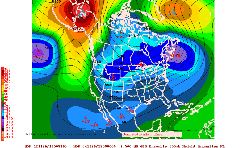
12zECMWF Ensemble Mean 500mb Anomalies forecast for Monday....Look at those positive anomalies over Alaska!
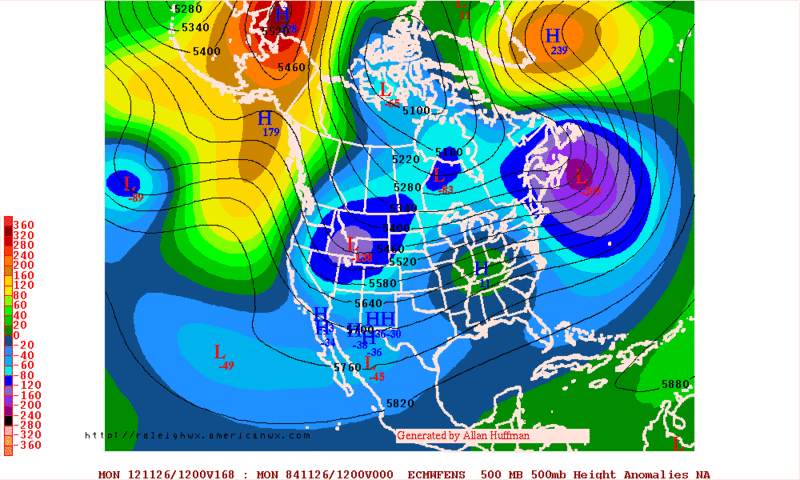
12zGFS Ensemble Mean 500mb Anomalies forecast for Monday....Agrees with the ECMWF.
0 likes
The following post is NOT an official forecast and should not be used as such. It is just the opinion of the poster and may or may not be backed by sound meteorological data. It is NOT endorsed by any professional institution including storm2k.org For Official Information please refer to the NHC and NWS products.
-
Terri

- Tropical Low

- Posts: 43
- Joined: Sun Aug 12, 2012 11:54 am
- Location: Williamson County - NW of Georgetown, Tx
Re: Texas Fall 2012
0 likes
Terri
Rural Williamson County, Tx
Rural Williamson County, Tx
-
Portastorm
- Storm2k Moderator
- Posts: 9955
- Age: 63
- Joined: Fri Jul 11, 2003 9:16 am
- Location: Round Rock, TX
- Contact:
Re: Texas Fall 2012
The Portastorm Weather Center's Tuesday of Thanksgiving Week Thoughts:
Was the 49ers offense last night the most amazing, unconventional NFL offense you've ever seen or what?! And my goodness, how could my Texas Longhorns lose in basketball to a Division 2 school (Chaminade)?! Oh wait ... off topic. Sorry.
The operational GFS is back to its old crazy, inconsistent self. Too bad. I thought it did well during the tropical season too.
Both the 0z and 6z runs take the cold air dump and sling it eastwards with a much less pronounced southward motion. The cold air really impacts the Great Lakes and Northeast US in the 7-15 day range. For us (Texas), maybe a slight and transient visit to slightly below normal temps. The reason why I'm not sold on this GFS scenario is that in previous fall/winter seasons we have seen the model latch on to something long range (12-15 days out), lose it in the medium range (6-10 days) and then find it again in the short range (5 days and less). Considering this and considering that the 6z run blowtorches the entire nation in the long range and that is a dramatic departure from the 0z run.
Now, the 0z Euro op run does show something similar in that the cold air dump is also more west to east than previous runs. The key seems to be the polar vortex (or a piece of the polar vortex) which ends up more in eastern Canada and not the middle of Canada like in previous runs. The key here is that the polar vortex is almost like a directional nozzle for the cold air. Also the west coast high pressure ridging up into Alaska in previous runs is much less pronounced.
I'll be curious how the ensembles look today to see if this is a trend worth noting or merely operational run noise from both models. Pattern changes like this are known to create some chaos in operational model runs.
0 likes
Any forecasts under my name are to be taken with a grain of salt. Get your best forecasts from the National Weather Service and National Hurricane Center.
Great stuff Portastorm! Soon we'll have to pay for your stuff if you keep this kind of forecasting up 
The GFS is disconnected with the PNA. It is flatter with it, letting the cutoff storm underneath the Alaskan ridge take over. I think it's more likely to hand vorticity south than go the scenario is currently showing, we shall see still many many days to go.
Edit: And I hope people don't assume it's one massive front that plows through everything. It's going to be several beginning this Friday. Each one knocking down temperatures and probably the biggest one to round out the month.
0 likes
The above post and any post by Ntxw is NOT an official forecast and should not be used as such. It is just the opinion of the poster and may or may not be backed by sound meteorological data. It is NOT endorsed by any professional institution including Storm2k. For official information, please refer to NWS products.
Help support Storm2K!
Help support Storm2K!
-
horselattitudesfarm

- Category 1

- Posts: 315
- Joined: Thu Jul 16, 2009 5:55 pm
- Location: Asheville, NC (formerly from Dallas, TX)
Re: Texas Fall 2012
Looking at the long-range, I can pretty much gamble money on that we will have the big goose-egg for precip at our house for November. I cannot remember EVER having a dry November without a drop of rain  To prove it I looked at the Lavon Dam Climatology records back to 1950. November 1950 had .06" so it looks like we are less than that.
0 likes
-
horselattitudesfarm
- Category 1
- Posts: 315
- Joined: Thu Jul 16, 2009 5:55 pm
- Location: Asheville, NC (formerly from Dallas, TX)
Re:
Looks like both models are trying to pull a southern low into texas at the end of the monthRgv20 wrote::uarrow: More importantly the ECMWF and GFS Ensemble Member seem to agree with the overall pattern late this month.
12zECMWF Ensemble Mean 500mb Anomalies forecast for Monday....Look at those positive anomalies over Alaska!
12zGFS Ensemble Mean 500mb Anomalies forecast for Monday....Agrees with the ECMWF.
0 likes
Return to “USA & Caribbean Weather”
Who is online
Users browsing this forum: AnnularCane and 108 guests