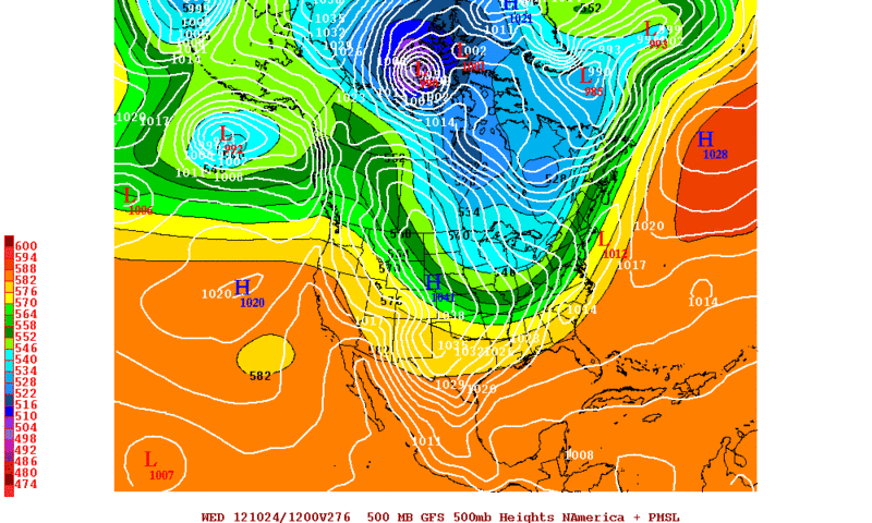
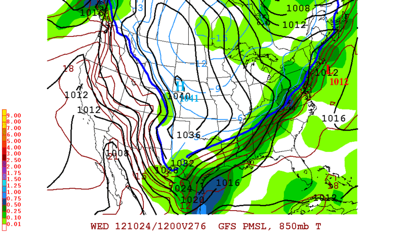
Terri wrote:The thrill is gone. Somebody out there give me give me some hope..... Halloween?
Don't worry it will come

Moderator: S2k Moderators
Terri wrote:The thrill is gone. Somebody out there give me give me some hope..... Halloween?


TeamPlayersBlue wrote:The biggest cold shot i remember was on thanksgiving 2009 i believe. Driving to UT for the UT-A&M game, temp dropped from 80, to the 40's in half an hour. Was in the 30's by game time and was fairly windy for the game. On my way back home that night, Houston was covered with continuous rain showers.


Portastorm wrote:The Portastorm Weather Center has temporarily relocated for the weekend to Lubbock. I'm hoping to see some severe weather this evening and may even get to do a little chasing with some Texas Tech kids who do a lot of chasing. Out here this weekend to check on my investment (college freshman). Woot!

TeamPlayersBlue wrote:Yeah that was a memorable Thanksgiving. The ice even went down to San Antonio before it was all said and done that night. A nice chill in the air is always welcome around the holidays. This year i may be in Ft. Lauderdale with family though. In 2010 I was there for Christmas and it was brutally cold. Dipped below freezing or was close to freezing more than once and wasnt very warm at all in between fronts.


URGENT - IMMEDIATE BROADCAST REQUESTED
TORNADO WATCH NUMBER 661
NWS STORM PREDICTION CENTER NORMAN OK
100 PM CDT SAT OCT 13 2012
THE NWS STORM PREDICTION CENTER HAS ISSUED A
TORNADO WATCH FOR PORTIONS OF
WESTERN AND CENTRAL OKLAHOMA
NORTHWEST TEXAS
EFFECTIVE THIS SATURDAY AFTERNOON AND EVENING FROM 100 PM UNTIL
900 PM CDT.
TORNADOES...HAIL TO 2 INCHES IN DIAMETER...THUNDERSTORM WIND
GUSTS TO 70 MPH...AND DANGEROUS LIGHTNING ARE POSSIBLE IN THESE
AREAS.
THE TORNADO WATCH AREA IS APPROXIMATELY ALONG AND 65 STATUTE
MILES EAST AND WEST OF A LINE FROM 45 MILES EAST NORTHEAST OF
ALVA OKLAHOMA TO 20 MILES SOUTH SOUTHWEST OF ABILENE TEXAS. FOR
A COMPLETE DEPICTION OF THE WATCH SEE THE ASSOCIATED WATCH
OUTLINE UPDATE (WOUS64 KWNS WOU1).
REMEMBER...A TORNADO WATCH MEANS CONDITIONS ARE FAVORABLE FOR
TORNADOES AND SEVERE THUNDERSTORMS IN AND CLOSE TO THE WATCH
AREA. PERSONS IN THESE AREAS SHOULD BE ON THE LOOKOUT FOR
THREATENING WEATHER CONDITIONS AND LISTEN FOR LATER STATEMENTS
AND POSSIBLE WARNINGS.
DISCUSSION...THUNDERSTORM DEVELOPMENT IS LIKELY IN THE NEXT COUPLE
OF HOURS FROM NW TX INTO WRN OK...ALONG AND JUST E OF THE SURFACE
COLD FRONT. A NARROW ZONE OF SURFACE HEATING TO THE W OF THE
ONGOING CONVECTION FROM N TX INTO CENTRAL OK...AND BOUNDARY LAYER
DEWPOINTS IN THE UPPER 60S...ARE SUPPORTING MLCAPE NEAR 2000 J/KG.
DEEP-LAYER AND LOW-LEVEL VERTICAL SHEAR ARE FAVORABLE FOR
SUPERCELLS...AND THE CONVECTIVE MODE SHOULD BE A MIX OF
SEMI-DISCRETE CELLS AND LINE SEGMENTS THROUGH THE AFTERNOON. A FEW
TORNADOES WILL BE POSSIBLE WITH THE MORE DISCRETE STORMS THROUGH THE
AFTERNOON/EVENING...ALONG WITH LARGE HAIL. DAMAGING WINDS WILL
BECOME MORE OF A THREAT LATER AS STORMS POTENTIALLY EVOLVE INTO A
MORE SOLID LINE CLOSER TO I-35 IN OK.
AVIATION...TORNADOES AND A FEW SEVERE THUNDERSTORMS WITH HAIL
SURFACE AND ALOFT TO 2 INCHES. EXTREME TURBULENCE AND SURFACE
WIND GUSTS TO 60 KNOTS. A FEW CUMULONIMBI WITH MAXIMUM TOPS TO
500. MEAN STORM MOTION VECTOR 24035.


TeamPlayersBlue wrote:Who else is being dominated by allergies for the last week. Killing me over here.
Return to “USA & Caribbean Weather”
Users browsing this forum: No registered users and 173 guests