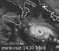

Initially, some models, saw the development of a Mediterranean hurricane..
Estofex (European Storm Forecast): "It is interesting to note that at this moment several models develop it into a hurricane-like structure (e.g. warm core and eye) on Monday, and the currently unusually high sea surface temperatures would assist such development."

This will not be verified, but it was formed, however, a small storm with tropical caracteristics.
A storm circulation move over warm water of Italian coast (26-27°C, 28°C south Tyrrhenian).
probably weakening in the next hours:
http://www.yr.no/satellitt/europa_animasjon.html
http://www.sat24.com/it/it


