wxman57 wrote:ROCK wrote:100% sure we will have less storms in Sept than August? did I hear that right?
Yep, 100% sure. We had 8 form in August. Odds of 8 forming in September are remote.
Btw, wxman, how ya doin' in your office pool?
Moderator: S2k Moderators

wxman57 wrote:ROCK wrote:100% sure we will have less storms in Sept than August? did I hear that right?
Yep, 100% sure. We had 8 form in August. Odds of 8 forming in September are remote.

floridasun78 wrote:i see models want make LESLIE do loop
rainstorm wrote:some of us who enjoy tropical weather eagerly look forward to aug/sept. say anything you want, but 2004/05 were 2 years tropical enthuiasts will never forget. and before anyone blasts me, nothing i want or dont want has anything to do with what the weather does, so no guilt trips. in tornado season tornado chasers hope and pray for tornados to chase, but i dont get mad at them. in winter, many people want bitter cold and snow, which can also cause extreme hardship for many, but again, i dont get upset over it. i chase tropical weather the only way i can, over the computer.
back to leslie, looking sick poor girl.

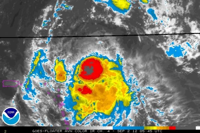
ozonepete wrote:Improving again, at least temporarily...
http://i189.photobucket.com/albums/z174 ... 020545.jpg
cheezyWXguy wrote:ozonepete wrote:Improving again, at least temporarily...
http://i189.photobucket.com/albums/z174 ... 020545.jpg
yeah, shes been holding some fairly deep convection for sometime now, but it still appears the low level center is pretty significantly displaced.


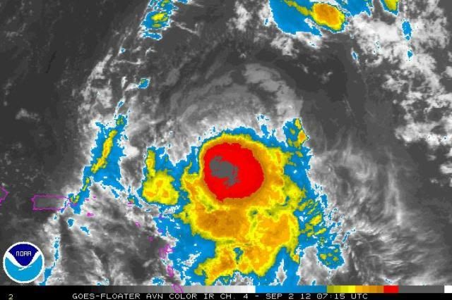
TROPICAL STORM LESLIE ADVISORY NUMBER 12
NWS NATIONAL HURRICANE CENTER MIAMI FL AL122012
500 AM AST SUN SEP 02 2012
...LESLIE STRENGTHENS SLIGHTLY AS IT CONTINUES TO MOVE NORTHWESTWARD
AWAY FROM THE LEEWARD ISLANDS...
SUMMARY OF 500 AM AST...0900 UTC...INFORMATION
----------------------------------------------
LOCATION...20.8N 59.5W
ABOUT 295 MI...475 KM NNE OF THE LEEWARD ISLANDS
MAXIMUM SUSTAINED WINDS...70 MPH...110 KM/H
PRESENT MOVEMENT...NW OR 310 DEGREES AT 15 MPH...24 KM/H
MINIMUM CENTRAL PRESSURE...994 MB...29.35 INCHES
WATCHES AND WARNINGS
--------------------
THERE ARE NO COASTAL WATCHES OR WARNINGS IN EFFECT.
DISCUSSION AND 48-HOUR OUTLOOK
------------------------------
AT 500 AM AST...0900 UTC...THE CENTER OF TROPICAL STORM LESLIE WAS
LOCATED NEAR LATITUDE 20.8 NORTH...LONGITUDE 59.5 WEST. LESLIE IS
MOVING TOWARD THE NORTHWEST NEAR 15 MPH...24 KM/H...AND THIS
GENERAL MOTION IS FORECAST TO CONTINUE TODAY. A GRADUAL TURN TOWARD
THE NORTH-NORTHWEST AND NORTH...ALONG WITH A DECREASE IN FORWARD
SPEED...IS EXPECTED DURING THE NEXT COUPLE OF DAYS. ON THE FORECAST
TRACK...THE CENTER OF LESLIE WILL CONTINUE TO MOVE AWAY FROM THE
LEEWARD ISLANDS.
MAXIMUM SUSTAINED WINDS ARE NEAR 70 MPH...110 KM/H...WITH HIGHER
GUSTS. LESLIE IS CURRENTLY IN AN AREA OF UNFAVORABLE UPPER-LEVEL
WINDS...AND SOME FLUCTUATIONS IN STRENGTH WILL BE POSSIBLE DURING
THE NEXT 48 HOURS.
TROPICAL-STORM-FORCE WINDS EXTEND OUTWARD UP TO 175 MILES...280 KM
FROM THE CENTER. NOAA BUOY 41044...LOCATED NORTH OF THE CENTER...
HAS BEEN REPORTING 1-MINUTE MEAN WINDS OF 50 MPH...80 KM/HR...WITH
GUSTS TO NEAR 60 MPH...92 KM/HR...OVER THE PAST FEW HOURS.
THE ESTIMATED MINIMUM CENTRAL PRESSURE IS 994 MB...29.35 INCHES.
HAZARDS AFFECTING LAND
----------------------
SURF...SWELLS GENERATED BY LESLIE COULD AFFECT PORTIONS OF THE
LEEWARD ISLANDS THROUGH THE WEEKEND...AND BEGIN TO AFFECT PUERTO
RICO AND THE VIRGIN ISLANDS LATER TODAY. THESE SWELLS COULD
CAUSE LIFE-THREATENING SURF AND RIP CURRENT CONDITIONS. PLEASE
CONSULT PRODUCTS FROM YOUR LOCAL WEATHER OFFICE.
NEXT ADVISORY
-------------
NEXT COMPLETE ADVISORY...1100 AM AST.
$$
FORECASTER STEWART


ozonepete wrote:wxman57 wrote:ROCK wrote:100% sure we will have less storms in Sept than August? did I hear that right?
Yep, 100% sure. We had 8 form in August. Odds of 8 forming in September are remote.
Btw, wxman, how ya doin' in your office pool?

wxman57 wrote:
As for Leslie this morning, I find it extremely hard to believe it's a 65-70 mph TS. It doesn't even look like a TS. Without significant organized convection, how is it bringing any stronger winds aloft down to the surface?


Incident_MET wrote:The 12z BAM guidance initialization showed a current course of 305 degrees. That doesn't look to be the case to me based on morning VIS imagery. Looks close to west. Withour planned recon, forecast tracks will remain subject to quality of the global guid without any aircraft input.

Users browsing this forum: No registered users and 17 guests