
I sort of have a general question about the visible satellite images.
http://www.ssd.noaa.gov/goes/east/carb/flash-vis.html
You can see around this time that the image changes bit by bit as the sun goes down. The visible images don't go "dark" but they definitely look different than in the daytime.
How are those images being generated at night?
ATL: LESLIE - Post-Tropical - Discussion
Moderator: S2k Moderators
-
hurricanes1234
- Category 5

- Posts: 2908
- Joined: Sat Jul 28, 2012 6:19 pm
- Location: Trinidad and Tobago
Re: ATL: LESLIE - Tropical Storm - Discussion
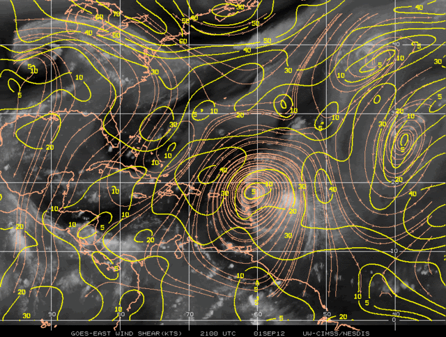
ozonepete wrote: Yes, 1234, there is murderous shear ahead of Leslie - 30 to 40 knots of southerly shear. Can't see how it could ever survive this, unless the shear gradually abates as Leslie moves into it overnight and tomorrow, but I don't see that happening.
brunota2003 wrote:Visible imagery certainly paints a horrible picture of Leslie...with the LLC running away from the convection, with deep convection present only in the far SE portions. Last couple frames of AVN make it look like the convection is trying to jump NW toward the LLC, but doubt it'll make it there, at least in any substantial form.
I agree with you both, I don't see Leslie passing 75 mph at its peak, the wind shear is just too strong for this storm to reattach, unless it subsides. 40 knots of wind shear is just crazy. In fact, there is an area near the Bahamas that has 60 knots of wind shear, which can rip a storm apart completely in a matter of hours. Many storms this year have had problems with shear, but this is the most severe case so far. Looking at the shear map when Leslie was forming, I didn't think it would pass directly into that hostile wind shear, but it seems like it was a less fortunate storm. If Leslie doesn't get out of that area soon, we could be watching the dying stages of her as early as tomorrow.
The posts in this forum are NOT official forecast and should not be used as such. They are just the opinion of the poster and may or may not be backed by sound meteorological data. They are NOT endorsed by any professional institution or storm2k.org. For official information, please refer to the NHC and NWS products.
0 likes
PLEASE NOTE: With the exception of information from weather agencies that I may copy and paste here, my posts will NEVER be official, since I am NOT a meteorologist. They are solely my amateur opinion, and may or may not be accurate. Therefore, please DO NOT use them as official details, particularly when making important decisions. Thank you.

Re: Re:
[/quote]
If not overachieving means that we don't have any storms that do catastrophic damage over land or take massive amounts of life, then I am quite comfortable with having storms that do not overachieve. We have had way too many people this year wanting storms to be majors while at the same time seeming to not care where these majors could end up and who they could affect. A set up that does not lead to a major storm is not disappointing, it is relieving. Leslie can sit and spin SE of Bermuda until late November if it ensured we didn't have a chance of a landfalling storm the rest of the year! Sometimes in people's enthusiasm for a major storm, I wonder how old people are or if they live anywhere close to areas that could be affected.[/quote]
Well said Sandbar!
0 likes
Too many hurricanes to remember
-
rainstorm
some of us who enjoy tropical weather eagerly look forward to aug/sept. say anything you want, but 2004/05 were 2 years tropical enthuiasts will never forget. and before anyone blasts me, nothing i want or dont want has anything to do with what the weather does, so no guilt trips. in tornado season tornado chasers hope and pray for tornados to chase, but i dont get mad at them. in winter, many people want bitter cold and snow, which can also cause extreme hardship for many, but again, i dont get upset over it. i chase tropical weather the only way i can, over the computer.
back to leslie, looking sick poor girl.
back to leslie, looking sick poor girl.
0 likes
Re: ATL: LESLIE - Tropical Storm - Discussion
wxman57 wrote:Anthysteg00 wrote:With all due respect, isn't a remote possibility still a percentage? I am curious, is there any reason to assume September will slow down? GFS predicted no activity for a long time recently and I'm here to tell you on the NGOM that didn't pan out . Leslie is getting wrecked by shear how do the models respond to that?
Active MJO phase has ended. Sinking air moving into western Atlantic basin. Should be much calmer at least the first half of September:
http://www.cpc.ncep.noaa.gov/products/p ... orca.shtml
And as I remember WX57 that's why you pegged August(back in early July) to be active in part was the MJO going active and now it's moving out
0 likes
Re: ATL: LESLIE - Tropical Storm - Discussion
bonjourno wrote:I sort of have a general question about the visible satellite images.
http://www.ssd.noaa.gov/goes/east/carb/flash-vis.html
You can see around this time that the image changes bit by bit as the sun goes down. The visible images don't go "dark" but they definitely look different than in the daytime.
How are those images being generated at night?
If I am not mistaken it's sort of infra red?
0 likes

Re: ATL: LESLIE - Tropical Storm - Discussion
trying to build over the LLC but not any closer than it was earlier....serious displaced MLC....the northern islands might get a few bands as it moves by...
0 likes
-
ozonepete
- Professional-Met

- Posts: 4743
- Joined: Mon Sep 07, 2009 3:23 pm
- Location: From Ozone Park, NYC / Now in Brooklyn, NY
Re: ATL: LESLIE - Tropical Storm - Discussion
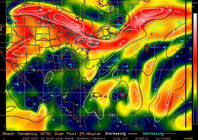
This is why analysing and forecasting shear is a nightmare, and why the models, the NHC and the rest of us have so much trouble getting intensity right. Look at the latest chart from CIMSS for current shear and the chart for trend of shear over the previous 24 hours. According to these charts Leslie (near 20N, 58N now) is moving into an area of very low shear! And it looks like the heavy shear zone to its west and northwest is retreating slowly westward and reducing in areal coverage compared to prior charts. If this becomes a trend it could allow Leslie to intensify a lot again. It just makes me crazy. It is one of the least forecastable parameters in meteorology today because it is by necessity only important over the open water where we have very few, if any, actual upper air observations.
So what should we think now? Don't ask me, lol. But one thing I do is watch the cirrus cloud movement (very high thin wispy clouds at jet level 300 to 200mb) and how they are moving. For optimum development (low shear) there should be no cirrus moving over the center but a lot of it fanning out in a clockwise direction over the top of the center. The RGB satellite, even at night, shows it best (look for high thin bluish clouds). In this case, if you look at the RGB sat loops (not shown) you can see cirrus moving from north to south over Leslie's center (northerly shear), but the cirrus to the west and northwest are blowing from the south (southerly shear) but not too strongly. So maybe the shear zone west of Leslie is easing off.
BTW, shear is deep layer, so that cirrus only tell you about upper level flow. I also watch mid level cloud movement and that is a lot more tricky. I can't get into that here.
0 likes
-
hurricanes1234
- Category 5
- Posts: 2908
- Joined: Sat Jul 28, 2012 6:19 pm
- Location: Trinidad and Tobago
Re: Re:
msbee wrote: If not overachieving means that we don't have any storms that do catastrophic damage over land or take massive amounts of life, then I am quite comfortable with having storms that do not overachieve. We have had way too many people this year wanting storms to be majors while at the same time seeming to not care where these majors could end up and who they could affect. A set up that does not lead to a major storm is not disappointing, it is relieving. Leslie can sit and spin SE of Bermuda until late November if it ensured we didn't have a chance of a landfalling storm the rest of the year! Sometimes in people's enthusiasm for a major storm, I wonder how old people are or if they live anywhere close to areas that could be affected.[/b][/quote]
Reply written by hurricanes1234: That's why we say we want FISH storms. Fish storms are storms like Kirk, that are of no threat to land - they stay out in the open waters. I hope you don't think that we don't care about landfalling storms, of course we do, but for the lovers of mother nature, all we want is to see something amazing. Check back our posts properly, and you'll see that most of us say that we want storms that become major to stay out to sea. For you to say that we give no care about major hurricanes making landfall is extremely untrue, because none of us have ever said that. As I said, if you carefully look through our posts, every time a storm forms, we CLEARLY state that we hope it doesn't affect anyone, so that statement you made about us not caring is rather bold and judgemental.
Reply written by hurricanes1234: That's why we say we want FISH storms. Fish storms are storms like Kirk, that are of no threat to land - they stay out in the open waters. I hope you don't think that we don't care about landfalling storms, of course we do, but for the lovers of mother nature, all we want is to see something amazing. Check back our posts properly, and you'll see that most of us say that we want storms that become major to stay out to sea. For you to say that we give no care about major hurricanes making landfall is extremely untrue, because none of us have ever said that. As I said, if you carefully look through our posts, every time a storm forms, we CLEARLY state that we hope it doesn't affect anyone, so that statement you made about us not caring is rather bold and judgemental.
0 likes
PLEASE NOTE: With the exception of information from weather agencies that I may copy and paste here, my posts will NEVER be official, since I am NOT a meteorologist. They are solely my amateur opinion, and may or may not be accurate. Therefore, please DO NOT use them as official details, particularly when making important decisions. Thank you.
-
ozonepete
- Professional-Met
- Posts: 4743
- Joined: Mon Sep 07, 2009 3:23 pm
- Location: From Ozone Park, NYC / Now in Brooklyn, NY
Re: ATL: LESLIE - Tropical Storm - Discussion
this discussion pops up frequently every new season. We should always assume that no one wants harm to come to anyone but most of us love to see a big powerful hurricane because they are fascinating to us. I have always found that the few nuts who want to see destruction usually expose themselves sooner or later and then they'll feel the heat from the rest of us. 
It's quite clear, 1234, that you have the right attitude. I don't think he meant you.
It's quite clear, 1234, that you have the right attitude. I don't think he meant you.
0 likes
-
wxman57

- Moderator-Pro Met

- Posts: 23172
- Age: 68
- Joined: Sat Jun 21, 2003 8:06 pm
- Location: Houston, TX (southwest)
Re: ATL: LESLIE - Tropical Storm - Discussion
Javlin wrote:bonjourno wrote:I sort of have a general question about the visible satellite images.
http://www.ssd.noaa.gov/goes/east/carb/flash-vis.html
You can see around this time that the image changes bit by bit as the sun goes down. The visible images don't go "dark" but they definitely look different than in the daytime.
How are those images being generated at night?
If I am not mistaken it's sort of infra red?
Correct. The satellite has an infrared sensor that measures temperature differences. Colder temps relate to the higher clouds, warmer temps the lower clouds. Resolution isn't as high as for daytime visible imagery.
Looks terrible on satellite. Not sure the circulation center will survive the shear. Looks to be over 100 miles NW of the nearest convection now. Close to 21N.
0 likes
-
ozonepete
- Professional-Met
- Posts: 4743
- Joined: Mon Sep 07, 2009 3:23 pm
- Location: From Ozone Park, NYC / Now in Brooklyn, NY
Re: ATL: LESLIE - Tropical Storm - Discussion
wxman57 wrote:Looks terrible on satellite. Not sure the circulation center will survive the shear. Looks to be over 100 miles NW of the nearest convection now. Close to 21N.
Hey wxman, what did you think about what I posted on the shear trend? I'm sure (well, think) you would agree it is very tricky at this point. Do you see the possibility that shear will drop after all? I haven't looked at the shear forecast from GFS yet but will try to get to it.
0 likes
-
Hurricaneman

- Category 5
- Posts: 7404
- Age: 45
- Joined: Tue Aug 31, 2004 3:24 pm
- Location: central florida
Re: ATL: LESLIE - Tropical Storm - Discussion
If the shear doesn't let up, by tomorrow we may be tracking an open wave with a good MLC which would go against all the NHC forecast, what could that possibly do to the track, much farther west, or the same track as forecast
The posts in this forum are NOT official forecast and should not be used as such. They are just the opinion of the poster and may or may not be backed by sound meteorological data. They are NOT endorsed by any professional institution or storm2k.org. For official information, please refer to the NHC and NWS products.
The posts in this forum are NOT official forecast and should not be used as such. They are just the opinion of the poster and may or may not be backed by sound meteorological data. They are NOT endorsed by any professional institution or storm2k.org. For official information, please refer to the NHC and NWS products.
0 likes
-
Hurricane Alexis

- Category 2

- Posts: 683
- Age: 29
- Joined: Thu Jun 14, 2012 7:59 pm
- Location: Miami,Florida
Re: ATL: LESLIE - Tropical Storm - Discussion
Hurricaneman wrote:If the shear doesn't let up, by tomorrow we may be tracking an open wave with a good MLC which would go against all the NHC forecast, what could that possibly do to the track, much farther west, or the same track as forecast
The posts in this forum are NOT official forecast and should not be used as such. They are just the opinion of the poster and may or may not be backed by sound meteorological data. They are NOT endorsed by any professional institution or storm2k.org. For official information, please refer to the NHC and NWS products.
It should go farther west since it will be guided the lower level flow.
0 likes
Personal Forecast Disclaimer:
The posts in this forum are NOT official forecast and should not be used as such. They are just the opinion of the poster and may or may not be backed by sound meteorological data. They are NOT endorsed by any professional institution or storm2k.org. For official information, please refer to the NHC and NWS products.
The posts in this forum are NOT official forecast and should not be used as such. They are just the opinion of the poster and may or may not be backed by sound meteorological data. They are NOT endorsed by any professional institution or storm2k.org. For official information, please refer to the NHC and NWS products.

Re: ATL: LESLIE - Tropical Storm - Discussion
ozonepete wrote:this discussion pops up frequently every new season. We should always assume that no one wants harm to come to anyone but most of us love to see a big powerful hurricane because they are fascinating to us. I have always found that the few nuts who want to see destruction usually expose themselves sooner or later and then they'll feel the heat from the rest of us.
It's quite clear, 1234, that you have the right attitude. I don't think he meant you.
I agree, I never want to see anybody harmed but they are beautiful storms.. Leslie has tracked much further west than I thought.. waiting for the N curve..

0 likes
-
Hurricane Alexis
- Category 2
- Posts: 683
- Age: 29
- Joined: Thu Jun 14, 2012 7:59 pm
- Location: Miami,Florida
Re: ATL: LESLIE - Tropical Storm - Discussion
00z best track.
AL, 12, 2012090200, , BEST, 0, 198N, 578W, 55, 998, TS,
AL, 12, 2012090200, , BEST, 0, 198N, 578W, 55, 998, TS,
0 likes
Personal Forecast Disclaimer:
The posts in this forum are NOT official forecast and should not be used as such. They are just the opinion of the poster and may or may not be backed by sound meteorological data. They are NOT endorsed by any professional institution or storm2k.org. For official information, please refer to the NHC and NWS products.
The posts in this forum are NOT official forecast and should not be used as such. They are just the opinion of the poster and may or may not be backed by sound meteorological data. They are NOT endorsed by any professional institution or storm2k.org. For official information, please refer to the NHC and NWS products.
-
ozonepete
- Professional-Met
- Posts: 4743
- Joined: Mon Sep 07, 2009 3:23 pm
- Location: From Ozone Park, NYC / Now in Brooklyn, NY
Re: ATL: LESLIE - Tropical Storm - Discussion
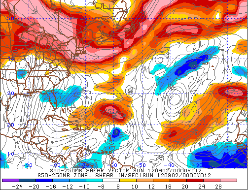
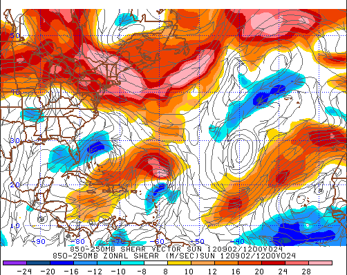
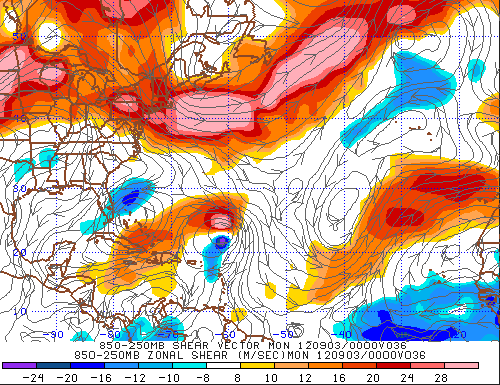
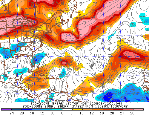
Here is the GFS shear forecast from the latest GFS tropical model output that was run this morning at 12Z. It shows shear dropping off a lot.
(For those who don't know these Penn State e-wall charts, the oranges are westerly shear and blues are easterly shear. The darker the color the higher the shear. BUT, shear close to the center needs to be discounted because the model is picking up on the storm winds themselves.)
FORECAST SHEAR for this evening at 8PM:
FORECAST SHEAR for tomorrow morning 8AM:
FORECAST SHEAR for tomorrow evening 8PM:
FORECAST SHEAR for Monday morning 8AM:
0 likes
-
ozonepete
- Professional-Met
- Posts: 4743
- Joined: Mon Sep 07, 2009 3:23 pm
- Location: From Ozone Park, NYC / Now in Brooklyn, NY
Re: ATL: LESLIE - Tropical Storm - Discussion
Hurricane Alexis wrote:Hurricaneman wrote:If the shear doesn't let up, by tomorrow we may be tracking an open wave with a good MLC which would go against all the NHC forecast, what could that possibly do to the track, much farther west, or the same track as forecast
The posts in this forum are NOT official forecast and should not be used as such. They are just the opinion of the poster and may or may not be backed by sound meteorological data. They are NOT endorsed by any professional institution or storm2k.org. For official information, please refer to the NHC and NWS products.
It should go farther west since it will be guided the lower level flow.
Right, BUT there is a little push to the north as well so it is going west-northwest.
0 likes
-
hurricanes1234
- Category 5
- Posts: 2908
- Joined: Sat Jul 28, 2012 6:19 pm
- Location: Trinidad and Tobago
Re: ATL: LESLIE - Tropical Storm - Discussion
08lava wrote:ozonepete wrote:this discussion pops up frequently every new season. We should always assume that no one wants harm to come to anyone but most of us love to see a big powerful hurricane because they are fascinating to us. I have always found that the few nuts who want to see destruction usually expose themselves sooner or later and then they'll feel the heat from the rest of us.
It's quite clear, 1234, that you have the right attitude. I don't think he meant you.
I agree, I never want to see anybody harmed but they are beautiful storms.. Leslie has tracked much further west than I thought.. waiting for the N curve..
Thanks.
0 likes
PLEASE NOTE: With the exception of information from weather agencies that I may copy and paste here, my posts will NEVER be official, since I am NOT a meteorologist. They are solely my amateur opinion, and may or may not be accurate. Therefore, please DO NOT use them as official details, particularly when making important decisions. Thank you.
-
SootyTern
- S2K Supporter

- Posts: 316
- Age: 57
- Joined: Sun Sep 05, 2004 5:09 pm
- Location: NYC (formerly Homestead, FL)
Re: ATL: LESLIE - Tropical Storm - Discussion
ozonepete wrote:this discussion pops up frequently every new season. We should always assume that no one wants harm to come to anyone but most of us love to see a big powerful hurricane because they are fascinating to us. I have always found that the few nuts who want to see destruction usually expose themselves sooner or later and then they'll feel the heat from the rest of us.
It's quite clear, 1234, that you have the right attitude. I don't think he meant you.
There is a huge difference between rooting for a gorgeous Cat 4 in a thread for a storm that is extremely likely to stay at sea versus one tracking over islands/Florida/into the Gulf like Isaac did last week. I wish the folks tracking from safe places could show more respect for the people going through the stress of a possible landfall in their world by just hiding their enthusiasm at that time. People in places like post-Katrina Gulf Coast have gone through traumas that people that haven't experienced it cannot understand. I gemerally get excited rather than scared about a TS/Cat 1 landfall over my house (ok more when I was a renter, less now that I am a homeowner) but I need to stuff my enthusiasm when around some of my friends that survived Andrew; even these smaller less damaging storms can stir up trauma/PTSD. A one line post complaining that a storm heading for somebody is a disappointment because it isn't stronger is unnecessary, IMO. On the other hand, if the storm is clearly not a threat to anybody, hope away!
0 likes
Who is online
Users browsing this forum: No registered users and 13 guests