ATL: ISAAC - Post-Tropical - Discussion
Moderator: S2k Moderators
Re: ATL: ISAAC - Hurricane - Discussion
GFS shows that Issac will move little over the next 12 hrs. It then will very slowly move north which shows strong convection pounding NO until tomorrow morning. This is really turning into a nightmare scenario with the prolonged battering. Damage will be much more than people expected.
GFS
GFS
0 likes
-
CYCLONE MIKE
- Category 5

- Posts: 2183
- Joined: Tue Aug 31, 2004 6:04 pm
- Location: Gonzales, LA
Re: ATL: ISAAC - Hurricane - Discussion
Will be interesting to see how much he tightens up and dare I say possibly strengthens as he can wrap that northern convection around the western and southern part of circulation.
0 likes
-
thatwhichisnt
- Tropical Depression

- Posts: 85
- Joined: Sat Aug 25, 2012 7:12 pm
Re: ATL: ISAAC - Hurricane - Discussion
Raining in Prairieville. If this thing keeps going NW Baton Rouge will be in the thick of it.
0 likes
-
CYCLONE MIKE
- Category 5

- Posts: 2183
- Joined: Tue Aug 31, 2004 6:04 pm
- Location: Gonzales, LA
Re: ATL: ISAAC - Hurricane - Discussion
Yeah Mike. I don't trust those types of models, but you have to give credit whenever it is due. Looking like contimed storminess at least for the next 4, 5, 6 (12?) hours. Unique ride for me, and I have been through more storms than I could count.
0 likes
-
thatwhichisnt
- Tropical Depression

- Posts: 85
- Joined: Sat Aug 25, 2012 7:12 pm
Re: ATL: ISAAC - Hurricane - Discussion
CYCLONE MIKE wrote:Whichisnt, whereabouts in pville you located?
Bluff and Old Perkins.
I think I accidentally sent you a PM.
0 likes
-
tolakram
- Admin

- Posts: 20179
- Age: 62
- Joined: Sun Aug 27, 2006 8:23 pm
- Location: Florence, KY (name is Mark)
Re: ATL: ISAAC - Hurricane - Discussion
Latest radar image (saved)

Radar estimated precip so far (saved)


Radar estimated precip so far (saved)

0 likes
M a r k
- - - - -
Join us in chat: Storm2K Chatroom Invite. Android and IOS apps also available.
The posts in this forum are NOT official forecasts and should not be used as such. Posts are NOT endorsed by any professional institution or STORM2K.org. For official information and forecasts, please refer to NHC and NWS products.
-
CYCLONE MIKE
- Category 5

- Posts: 2183
- Joined: Tue Aug 31, 2004 6:04 pm
- Location: Gonzales, LA
Re: ATL: ISAAC - Hurricane - Discussion
@ Steve
Well we are just now.starting to catch the western fringes now. Gusts up to 47 last I saw. Long day and night ahead I'm afraid. Any reports of major flooding due to surge or over-topping yet? Stay safe down there. Oh and.I'm thinking at least 12 more hrs.
Well we are just now.starting to catch the western fringes now. Gusts up to 47 last I saw. Long day and night ahead I'm afraid. Any reports of major flooding due to surge or over-topping yet? Stay safe down there. Oh and.I'm thinking at least 12 more hrs.
0 likes
-
tolakram
- Admin

- Posts: 20179
- Age: 62
- Joined: Sun Aug 27, 2006 8:23 pm
- Location: Florence, KY (name is Mark)
Re: ATL: ISAAC - Hurricane - Discussion
Radar estimated precip totals out of Mobile (saved)


0 likes
M a r k
- - - - -
Join us in chat: Storm2K Chatroom Invite. Android and IOS apps also available.
The posts in this forum are NOT official forecasts and should not be used as such. Posts are NOT endorsed by any professional institution or STORM2K.org. For official information and forecasts, please refer to NHC and NWS products.
- - - - -
Join us in chat: Storm2K Chatroom Invite. Android and IOS apps also available.
The posts in this forum are NOT official forecasts and should not be used as such. Posts are NOT endorsed by any professional institution or STORM2K.org. For official information and forecasts, please refer to NHC and NWS products.
-
thatwhichisnt
- Tropical Depression

- Posts: 85
- Joined: Sat Aug 25, 2012 7:12 pm
Re:
BigB0882 wrote:Have I missed much since I went to bed around midnight? Is this going to go further West and have us out of the worst or come NW and put us in the worst part OR even go due North and put us on the good side? What are they thinking now?
It is going west. We are in for a rough 24+ hours. One local met estimated 21 inches of rain, and Prairieville is expected to get 10+ hours of winds at 55-60 sustained and higher gusts.
0 likes
-
tolakram
- Admin

- Posts: 20179
- Age: 62
- Joined: Sun Aug 27, 2006 8:23 pm
- Location: Florence, KY (name is Mark)
Re: ATL: ISAAC - Hurricane - Discussion
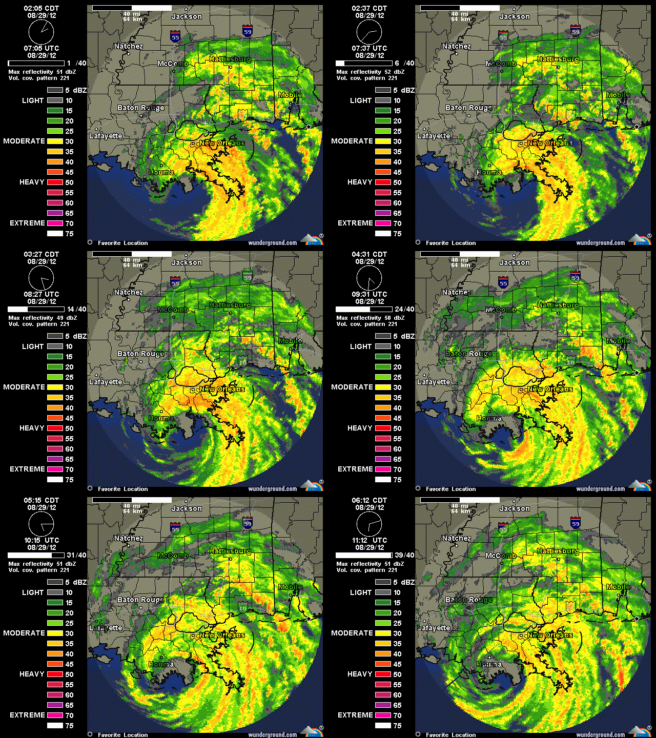
Latest saved loop, 40 frames, from New Orleans


0 likes
M a r k
- - - - -
Join us in chat: Storm2K Chatroom Invite. Android and IOS apps also available.
The posts in this forum are NOT official forecasts and should not be used as such. Posts are NOT endorsed by any professional institution or STORM2K.org. For official information and forecasts, please refer to NHC and NWS products.
- - - - -
Join us in chat: Storm2K Chatroom Invite. Android and IOS apps also available.
The posts in this forum are NOT official forecasts and should not be used as such. Posts are NOT endorsed by any professional institution or STORM2K.org. For official information and forecasts, please refer to NHC and NWS products.
-
thatwhichisnt
- Tropical Depression

- Posts: 85
- Joined: Sat Aug 25, 2012 7:12 pm
Re: ATL: ISAAC - Hurricane - Discussion
Looks like the eye is heading to around the Lafayette area.
0 likes
-
tolakram
- Admin

- Posts: 20179
- Age: 62
- Joined: Sun Aug 27, 2006 8:23 pm
- Location: Florence, KY (name is Mark)
Re: ATL: ISAAC - Hurricane - Discussion
Live IR loop: http://wwwghcc.msfc.nasa.gov/cgi-bin/ge ... =spect.pal
You can see the convection pulse as it hits water and circulates around.
Latest

You can see the convection pulse as it hits water and circulates around.
Latest

0 likes
M a r k
- - - - -
Join us in chat: Storm2K Chatroom Invite. Android and IOS apps also available.
The posts in this forum are NOT official forecasts and should not be used as such. Posts are NOT endorsed by any professional institution or STORM2K.org. For official information and forecasts, please refer to NHC and NWS products.
- - - - -
Join us in chat: Storm2K Chatroom Invite. Android and IOS apps also available.
The posts in this forum are NOT official forecasts and should not be used as such. Posts are NOT endorsed by any professional institution or STORM2K.org. For official information and forecasts, please refer to NHC and NWS products.
-
CYCLONE MIKE
- Category 5

- Posts: 2183
- Joined: Tue Aug 31, 2004 6:04 pm
- Location: Gonzales, LA
Re: ATL: ISAAC - Hurricane - Discussion
Not that I'm wanting this to occur but if he can continue drifting west some more and clear southern terrebonne his eye will likely be.completely over water again.
Whichisnt check your pm
Whichisnt check your pm
Last edited by CYCLONE MIKE on Wed Aug 29, 2012 6:27 am, edited 1 time in total.
0 likes
Re: ATL: ISAAC - Hurricane - Discussion
I really hate to say it, but Isaac looks more organized on radar, then he ever has.
0 likes
The preceding comments are never to be used as information to establish circumstances, plans or procedures for any weather related events. Only use official National Hurricane Center or National Weather Service information issued for your area.
Re: ATL: ISAAC - Hurricane - Discussion
Getting battered in Harrison county on the Ms Coast.Heavy rain,very strong gusty winds.
0 likes
- OzCycloneChaserTrav
- Tropical Low

- Posts: 30
- Age: 34
- Joined: Thu Aug 23, 2012 2:35 am
- Location: Townsville, Queensland Australia
- Contact:
At the end of this could someone save all radar images and put them in a loop for the last day. At the end of the event it would be cool to see all the radar imagery from Louisiana.
0 likes
Oz Cyclone Chasers ( Australian Cyclone Chasers )
Tropical Cyclone Ului Category 3 2010
Tropical Cyclone Anthony Category 2 2011
Tropical Cyclone Yasi Category 5 2011
Tropical Cyclone Lua Category 4 2012
Tropical Cyclone Dylan Category 2 2014
Tropical Cyclone Ita Category 5 2014
Tropical Cyclone Ului Category 3 2010
Tropical Cyclone Anthony Category 2 2011
Tropical Cyclone Yasi Category 5 2011
Tropical Cyclone Lua Category 4 2012
Tropical Cyclone Dylan Category 2 2014
Tropical Cyclone Ita Category 5 2014
This is not a "nightmare" for New Orleans. That happened 7 years ago. So, unless you're trying to convey that you think it'll be a repeat, lay off the dramatics when NOLA is involved, please. It's a nightmare for Buras, Plaquemines and other areas south and southwest of NOLA, but no reason to set NOLA lurkers' nerves even further on edge.
0 likes
Re: ATL: ISAAC - Hurricane - Discussion
No issues with the levees in new orleans. Those problems are down in lower plaq. City mostly has street flooding and power outages.
0 likes
Who is online
Users browsing this forum: No registered users and 40 guests

