ATL: ISAAC - Post-Tropical - Discussion
Moderator: S2k Moderators

-
ozonepete
- Professional-Met

- Posts: 4743
- Joined: Mon Sep 07, 2009 3:23 pm
- Location: From Ozone Park, NYC / Now in Brooklyn, NY
Re: ATL: ISAAC - Tropical Storm - Discussion
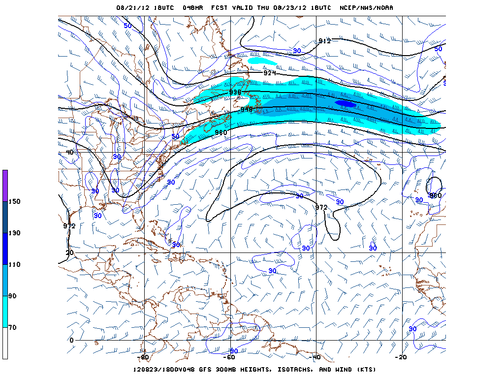
This is what I was saying about the shear ahead of Isaac. From the just issued 11PM discussion:
WATER VAPOR IMAGERY SUGGESTS THAT EAST-NORTHEASTERLY SHEAR IS CURRENTLY AFFECTING ISAAC...BUT THE DYNAMICAL GUIDANCE PREDICTS A DECREASE IN SHEAR WITH UPPER-LEVEL ANTICYCLONIC FLOW OVER THE TROPICAL CYCLONE DURING THE NEXT SEVERAL DAYS.
WATER VAPOR IMAGERY SUGGESTS THAT EAST-NORTHEASTERLY SHEAR IS CURRENTLY AFFECTING ISAAC...BUT THE DYNAMICAL GUIDANCE PREDICTS A DECREASE IN SHEAR WITH UPPER-LEVEL ANTICYCLONIC FLOW OVER THE TROPICAL CYCLONE DURING THE NEXT SEVERAL DAYS.
0 likes

THE GOVERNMENT OF ANTIGUA AND BARBUDA HAS CHANGED THE TROPICAL STORM
WATCH FOR THE BRITISH VIRGIN ISLANDS TO A TROPICAL STORM WARNING.
THE TROPICAL STORM WATCH FOR PUERTO RICO...VIEQUES...CULEBRA...AND
THE U.S. VIRGIN ISLANDS HAS BEEN CHANGED TO A TROPICAL STORM
WARNING.
A HURRICANE WATCH HAS BEEN ISSUED FOR PUERTO RICO...VIEQUES...
CULEBRA...AND THE U.S. VIRGIN ISLANDS.
SUMMARY OF WATCHES AND WARNINGS IN EFFECT...
A TROPICAL STORM WARNING IS IN EFFECT FOR...
* MARTINIQUE
* DOMINICA
* GUADELOUPE AND THE SURROUNDING ISLANDS...AND ST. MARTIN
* ST. KITTS...NEVIS...ANTIGUA...BARBUDA...MONTSERRAT...AND ANGUILLA
* SABA...ST. EUSTATIUS...AND ST. MAARTEN
* BRITISH VIRGIN ISLANDS
* PUERTO RICO...VIEQUES...CULEBRA...AND THE U.S. VIRGIN ISLANDS
A HURRICANE WATCH IS IN EFFECT FOR...
* PUERTO RICO...VIEQUES...CULEBRA...AND THE U.S. VIRGIN ISLANDS
0 likes
Re: ATL: ISAAC - Tropical Storm - Discussion
With some of these tracks, it looks like an awful lot of Cuba to have to go through. I can't really imagine it would have much left for Florida other than a big slug of moisture if it takes that kind of track over E and central Cuba. Only way I can see it being that substantial is if it took more of an under-and-up type track with minimal time over the big island.
Who knows. Will be interesting to watch in the coming days.
Just to inject a little levity.....how many times has South Florida been squarely in a 5-day cone over the last 10 years? Quite a few, if my memory serves me. How many of those actually turned out to be hits 5 days later?
Who knows. Will be interesting to watch in the coming days.
Just to inject a little levity.....how many times has South Florida been squarely in a 5-day cone over the last 10 years? Quite a few, if my memory serves me. How many of those actually turned out to be hits 5 days later?
0 likes

Re: ATL: ISAAC - Tropical Storm - Discussion
ozonepete wrote:This is what I was saying about the shear ahead of Isaac. From the just issued 11PM discussion:
WATER VAPOR IMAGERY SUGGESTS THAT EAST-NORTHEASTERLY SHEAR IS CURRENTLY AFFECTING ISAAC...BUT THE DYNAMICAL GUIDANCE PREDICTS A DECREASE IN SHEAR WITH UPPER-LEVEL ANTICYCLONIC FLOW OVER THE TROPICAL CYCLONE DURING THE NEXT SEVERAL DAYS.
hey look the NHC stole my post!! I knew they were in here somewhere watching....
0 likes
-
Shuriken
Re:
Most Caribbean-bound Cape Verde systems are about that size.KBBOCA wrote:[reposting this from the models thread where I posted it by mistake.]
I continue to be struck by the storm's potential size. I know it doesn't have huge windfields yet, nor a ton of convection, but if you look at some of the satellite images, particularly at StormCarib, you can see that the forming system basically fills an entire latitude - longitude "square". WOW. One possibly VERY LARGE storm.
http://stormcarib.com/goes.htm
Does anyone have easy access to comparison shots of other large storms... ?
Hurricane Igor (2010) is the largest Atlantic hurricane on record with a TS-force wind diameter of 920 miles. (Super-Typhoon Tip is the all-oceans champ with a 1380 mile diameter)
0 likes
-
Weatherfreak000
-
Deputy Van Halen
- Tropical Storm

- Posts: 104
- Joined: Thu Aug 03, 2006 12:00 am
- Location: Texas City, TX
Re: ATL: ISAAC - Tropical Storm - Discussion
As to this talk about the Tampa Republican convention that I'm sure most folks on this board are getting tired of already...
Masters earlier today said "I blogged about the climatological chances of a hurricane causing an evacuation of Tampa during the convention in a post last week, putting the odds at 0.2%. The odds in the current situation are higher, probably near 2%."
The exact meaning of that 2% seems kinda fuzzy to me. 2% chance of the NHC and mayor and FEMA and everyone else sounding the alarm and urging everyone in Tampa to get out of dodge? Or something not quite so dramatic?
Seems like the odds of Isaac affecting the convention in some significant way should be higher. Seeing how these tracks are so uncertain just a couple days out, and how the media will hype the storm, and how people involved in anything political are always quick to pick the "better safe than sorry" route (so as to put on display how much they "care", if nothing else)...it all feels like a mess waiting to happen.
0 likes
-
jaxfladude
- Category 5

- Posts: 1249
- Joined: Wed Aug 24, 2005 9:36 pm
- Location: Jacksonville, Fla
Re: ATL: ISAAC - Tropical Storm - Discussion
Personal Forecast Disclaimer:
The posts in this forum are NOT official forecast and should not be used as such. They are just the opinion of the poster and may or may not be backed by sound meteorological data. They are NOT endorsed by any professional institution or storm2k.org. For official information, please refer to the NHC.
Prayers to all of those who will feel the effects of Tropical Storm Isaac, track is bad all around, changes likely.
 Personal Forecast Disclaimer:
The posts in this forum are NOT official forecast and should not be used as such. They are just the opinion of the poster and may or may not be backed by sound meteorological data. They are NOT endorsed by any professional institution or storm2k.org. For official information, please refer to the NHC
The posts in this forum are NOT official forecast and should not be used as such. They are just the opinion of the poster and may or may not be backed by sound meteorological data. They are NOT endorsed by any professional institution or storm2k.org. For official information, please refer to the NHC.
Prayers to all of those who will feel the effects of Tropical Storm Isaac, track is bad all around, changes likely.
The posts in this forum are NOT official forecast and should not be used as such. They are just the opinion of the poster and may or may not be backed by sound meteorological data. They are NOT endorsed by any professional institution or storm2k.org. For official information, please refer to the NHC
0 likes
Stay safe y'all

Re: ATL: ISAAC - Tropical Storm - Discussion
ROCK wrote:I dont know how much its going to strengthen when it hits this 30knt shear zone in front of it..see the TUTT dropping down above...there is 30-40-50knts of shear in the carib right now...the reason someone said it was flattening out on the NW side is because it tasted some of that 30knt shear area.....just what I am seeing right now....
http://tropic.ssec.wisc.edu/real-time/w ... m=&time=-1
see the ULL dropping down...that will have an impact of it doesnt move out of the way in the next few days...
http://www.ssd.noaa.gov/goes/east/tatl/flash-wv.html
look at the current mid-shear right in the way....anyone remember 2006 Chris? models never picked up on that decapitation...
http://tropic.ssec.wisc.edu/real-time/w ... oom=&time=
Rock, all you have to do is look at the 5 day loop and see that the ULL has been moving westward ahead of Isaac out of its wasyall along during the past 5 days, and is not forecasted to stop over the next few days. The ULL anticyclone is forecasted to track along close to Isaac through at least the next 5 days.
http://tropic.ssec.wisc.edu/real-time/a ... rjava.html
0 likes
-
Shuriken
Re:
A Hurricane David (1979) analog track would have it ram the Dominican Republic full-tilt, then run up the spine of Florida after hitting the tip as a 90mph cat-1.Weatherfreak000 wrote:Jim cantore talks alot about Isaac and the EURO model. You can clearly tell he is concerned
-- That's probably the best case scenario involving a US landfalling hurricane; Gulf or Carolina hits would almost certainly be at Cat-2 or higher strength at this time of year.
0 likes
-
ozonepete
- Professional-Met
- Posts: 4743
- Joined: Mon Sep 07, 2009 3:23 pm
- Location: From Ozone Park, NYC / Now in Brooklyn, NY
Re: ATL: ISAAC - Tropical Storm - Discussion
Here's what we need to be looking at when we talk about shear. The forecast is much more important than the current shear.
These three charts show the GFS forecast shear from this morning's run. Notice how the shear weakens considerably ahead of the cyclone. Note that the red area of strong shear to the north of the center is where the model conflates local shear from the hurricane's winds with actual shear. So you need to discount any reds (westerly shear) or blues (easterly shear) close to the center. This forecast shows shear almost nil over Isaac for the next few days.
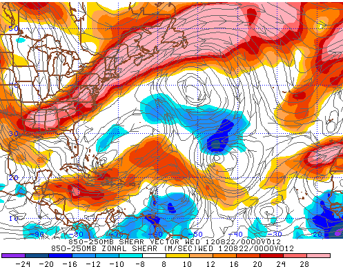
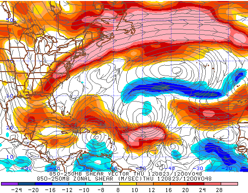
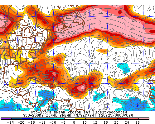
These three charts show the GFS forecast shear from this morning's run. Notice how the shear weakens considerably ahead of the cyclone. Note that the red area of strong shear to the north of the center is where the model conflates local shear from the hurricane's winds with actual shear. So you need to discount any reds (westerly shear) or blues (easterly shear) close to the center. This forecast shows shear almost nil over Isaac for the next few days.
0 likes
Re: ATL: ISAAC - Tropical Storm - Discussion
does look like its corrected for its earlier NW jog and has moved towards the stonger convection....
http://www.ssd.noaa.gov/PS/TROP/floater ... imated.gif
http://www.ssd.noaa.gov/PS/TROP/floater ... imated.gif
0 likes
-
ColdFusion

- S2K Supporter

- Posts: 452
- Joined: Wed Feb 13, 2008 3:46 pm
- Location: Addison, TX

-
SunnyThoughts
- Category 5
- Posts: 2263
- Joined: Wed Jul 09, 2003 12:42 pm
- Location: Pensacola, Florida

Re: ATL: ISAAC - Tropical Storm - Discussion
I see the NHC now has more land interaction than before. Looking at history it is a mixed bag in term of the land effects on a system. I am leaning towards greater disruption and limited ability to get very strong after the trek. Also, conditions have not been ideal this year in most of the basin for a rapid intensification. If it does get further north of Hispaniola then i would be very concerned.
David 1979 nailed Hispaniola but did not traverse much of Cuba and was a Cat5 and brought down to a TS.
http://weather.unisys.com/hurricane/atl ... /track.gif
Cleo 1964 had minimal interaction with Hispaniola and traversed Cuba and it went from Cat 4 down to Cat 1.
http://weather.unisys.com/hurricane/atl ... /track.gif
On the other side you have Georges 1998 that hit the three big islands and still managed to maintain hurricane status throughout the journey and be Cat 2 into the keys.
http://weather.unisys.com/hurricane/atl ... /track.gif
0 likes
The following post is NOT an official forecast and should not be used as such. It is just the opinion of the poster and may or may not be backed by sound meteorological data. It is NOT endorsed by any professional institution including storm2k.org For Official Information please refer to the NHC and NWS products.
-
stormhunter7

- Category 2

- Posts: 763
- Joined: Mon May 26, 2008 3:13 pm
- Location: Panama City Beach, Florida
- Contact:
Re: ATL: ISAAC - Tropical Storm - Discussion
AF307 Recon is airborne and heading to Isaac! 
0 likes
The following post is NOT an official forecast and should not be used as such. It is just the opinion of the poster and may or may not be backed by sound meteorological data. It is NOT endorsed by any professional institution including storm2k.org For Official Information please refer to the NHC and NWS products. http://www.nhc.noaa.gov

Re:
Weatherfreak000 wrote:Jim cantore talks alot about Isaac and the EURO model. You can clearly tell he is concerned
What is he saying about the EURO model that makes him concerned? Has the EURO shifted more to the east?
0 likes
-
floridasun78
- Category 5
- Posts: 3755
- Joined: Sun May 17, 2009 10:16 pm
- Location: miami fl
Who is online
Users browsing this forum: No registered users and 100 guests