ATL: ISAAC - Post-Tropical - Discussion

Moderator: S2k Moderators

Message
Author
User avatar
gatorcane
S2K Supporter
S2K Supporter
Posts: 23691
Age: 47
Joined: Sun Mar 13, 2005 3:54 pm
Location: Boca Raton, FL

#381 Postby gatorcane » Sun Aug 19, 2012 10:41 am

The posts in this forum are NOT official forecast and should not be used as such. They are just the opinion of the poster and may or may not be backed by sound meteorological data. They are NOT endorsed by any professional institution or storm2k.org. For official information, please refer to the NHC and NWS products.

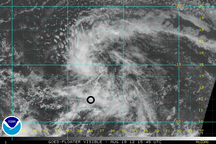
All - see annotated Visible (first image) and Water Vapor (second image) imagery below.

It's quite clear this system isn't going to be organizing quickly anytime soon. I mentioned this yesterday as well because though the system looked quite good, I still wanted to see how it handled the SAL and apparently it is taking quite a beating from it. That said I thought a low-end hurricane into the Leewards was possible but I am going to be lowering my intensity forecast on that, calling for no more than a tropical storm at this time. Reasons are: 1) SAL is everywhere 2) the Upper-Level low that I noted yesterday is moving SW and should start inducing a good amount of shear into the system in a few days. The problem with the intensity guidance like SHIPS and LGEM is that I don't think they are accounting for the SAL layer that is quite evident and is what I pointed out in yellow in the visible image. That SAL is all over the place out there and it looks more like mid July than August.

I expect the system to move quickly west and through or very near the northern Leewards over the next 5 days. Beyond that this system can find itself in a more favorable environment down the road especially once it gets past 65W. The SAL will still be around though so that could mean just a marginally favorable environment. Too early to say at this time. But I am a bit concerned about this system though because it may find itself in a more favorable environment downstream which could give it the the potential to ramp up pretty quickly (ala Ernesto and Helene)Image

Image
0 likes   

User avatar
Portastorm
Storm2k Moderator
Storm2k Moderator
Posts: 9914
Age: 63
Joined: Fri Jul 11, 2003 9:16 am
Location: Round Rock, TX
Contact:

Re: ATL: INVEST 94L

#382 Postby Portastorm » Sun Aug 19, 2012 10:49 am

:uarrow:

More excellent posts ... man, you Florida guys are rocking the house this morning! 8-) Keep it up. These are the best 94L discussions I'm seeing online in any forum.
0 likes   
Any forecasts under my name are to be taken with a grain of salt. Get your best forecasts from the National Weather Service and National Hurricane Center.

User avatar
perk
Category 3
Category 3
Posts: 825
Joined: Mon Aug 09, 2004 9:35 am
Location: Richmond Texas

Re: ATL: INVEST 94L

#383 Postby perk » Sun Aug 19, 2012 11:00 am

Portastorm wrote::uarrow:

More excellent posts ... man, you Florida guys are rocking the house this morning! 8-) Keep it up. These are the best 94L discussions I'm seeing online in any forum.


Portastorm i totally agree, i enjoyed the two posts you are reffering too.
0 likes   

CrazyC83
Professional-Met
Professional-Met
Posts: 34002
Joined: Tue Mar 07, 2006 11:57 pm
Location: Deep South, for the first time!

Re: ATL: INVEST 94L

#384 Postby CrazyC83 » Sun Aug 19, 2012 11:19 am

cycloneye wrote:Closed circulation? Well,this 41026 bouy has data of SW,WSW and West Winds.

http://www.ndbc.noaa.gov/station_page.php?station=41026


Indeed that is a case for TD9, even if it looks crap.
0 likes   

User avatar
Riptide
Category 2
Category 2
Posts: 753
Age: 34
Joined: Fri Jul 23, 2010 3:33 pm
Location: Cape May, New Jersey
Contact:

Re: ATL: INVEST 94L

#385 Postby Riptide » Sun Aug 19, 2012 11:22 am

CrazyC83 wrote:
cycloneye wrote:Closed circulation? Well,this 41026 bouy has data of SW,WSW and West Winds.

http://www.ndbc.noaa.gov/station_page.php?station=41026


Indeed that is a case for TD9, even if it looks crap.

Eh, it's not that bad; I have seen much worse looking tropical depressions in my days.
0 likes   

Jimsot
Tropical Storm
Tropical Storm
Posts: 157
Age: 77
Joined: Sat Sep 09, 2006 1:31 pm
Location: Upstate SC

Re: ATL: INVEST 94L

#386 Postby Jimsot » Sun Aug 19, 2012 11:25 am

Portastorm wrote::uarrow:

More excellent posts ... man, you Florida guys are rocking the house this morning! 8-) Keep it up. These are the best 94L discussions I'm seeing online in any forum.


I REALLY like that ULL sneaking southwest toward Anguilla for a little mischief. 8-)
0 likes   

RL3AO
Moderator-Pro Met
Moderator-Pro Met
Posts: 16308
Joined: Thu Jun 14, 2007 10:03 pm
Location: NC

#387 Postby RL3AO » Sun Aug 19, 2012 11:26 am

Image

Buoy location is circled.
0 likes   

Jimsot
Tropical Storm
Tropical Storm
Posts: 157
Age: 77
Joined: Sat Sep 09, 2006 1:31 pm
Location: Upstate SC

Re: ATL: INVEST 94L

#388 Postby Jimsot » Sun Aug 19, 2012 11:28 am

Is the LLC just to the North of that circle (buoy)?
0 likes   

hurricanes1234
Category 5
Category 5
Posts: 2907
Joined: Sat Jul 28, 2012 6:19 pm
Location: Trinidad and Tobago

Re: ATL: INVEST 94L

#389 Postby hurricanes1234 » Sun Aug 19, 2012 11:31 am

Personal Forecast Disclaimer:
The posts in this forum are NOT official forecast and should not be used as such. They are just the opinion of the poster and may or may not be backed by sound meteorological data. They are NOT endorsed by any professional institution or storm2k.org. For official information, please refer to the NHC and NWS

I am not experienced at studying tropical cyclones, but here's my discussion about 94L. Some things may be incorrect or a little mixed up.

Invest 94L is a developing tropical wave that moved off the coast of Africa into the eastern Atlantic earlier this week. As it moved off, it encountered warm SSTs of about 28°C and shear light enough, which allowed it to gradually become better defined. However, because of its rapid forward speed, it was only expected to slowly intensify. It has since slowed down in its speed from initially, which may allow it to soon become a tropical cyclone. Despite the slower forward speed, however, it appears to be ingesting dry, dusty air from the Saharan Air Layer, which has caused a temporary warming of the cloudtops. This is probably due to the storm turning northwest, into the drier air. Once the storm gets rid of the dry air inside of it, steady strengthening is anticipated, and this system could become a hurricane as early as next week. As of now, the NHC is giving it a high chance, 60%, of becoming a tropical cyclone within the next 48 hours.

Just my discussion, not an official forecast, and NOT meant to be used as such. For official forecasts, please see the NWS line of products.
0 likes   
PLEASE NOTE: With the exception of information from weather agencies that I may copy and paste here, my posts will NEVER be official, since I am NOT a meteorologist. They are solely my amateur opinion, and may or may not be accurate. Therefore, please DO NOT use them as official details, particularly when making important decisions. Thank you.

User avatar
cycloneye
Admin
Admin
Posts: 145307
Age: 68
Joined: Thu Oct 10, 2002 10:54 am
Location: San Juan, Puerto Rico

Re:

#390 Postby cycloneye » Sun Aug 19, 2012 11:32 am

RL3AO wrote:http://i44.photobucket.com/albums/f38/RL3AO/94lbouy.png

Buoy location is circled.


There are a couple of bouys that are ahead and more north in latitude that will be very valuable.
0 likes   
Visit the Caribbean-Central America Weather Thread where you can find at first post web cams,radars
and observations from Caribbean basin members Click Here

jinftl
Category 5
Category 5
Posts: 4312
Joined: Tue Aug 31, 2004 4:47 pm
Location: fort lauderdale, fl

Re: ATL: INVEST 94L

#391 Postby jinftl » Sun Aug 19, 2012 11:33 am

The following post is NOT an official forecast and should not be used as such. It is just the opinion of the poster and may or may not be backed by sound meteorological data. It is NOT endorsed by any professional institution including storm2k.org. For Official Information please refer to the NHC and NWS products.


I think 94L has been dumped by the board for not being in an RI phase by 35W (which no model called for, even yesterday)... once the model runs go out far enough to show what could happen after mid-week, people will jump back. Although 94L went from 'golden boy' to 'another pathetic invest' in 24 hours here, I think the story of 94L is only in Chapter 1. And by that, I mean I still believe it will develop into a named system and make it far enough west to effect some land area from Central America to Canada and every island in between as a named system (i.e., stronger than 39 mph winds).
Last edited by Portastorm on Sun Aug 19, 2012 11:40 am, edited 1 time in total.
Reason: added forecast disclaimer
0 likes   

Jimsot
Tropical Storm
Tropical Storm
Posts: 157
Age: 77
Joined: Sat Sep 09, 2006 1:31 pm
Location: Upstate SC

Re: ATL: INVEST 94L

#392 Postby Jimsot » Sun Aug 19, 2012 11:40 am

jinftl wrote:I think 94L has been dumped by the board for not being in an RI phase by 35W (which no model called for, even yesterday)... once the model runs go out far enough to show what could happen after mid-week, people will jump back. Although 94L went from 'golden boy' to 'another pathetic invest' in 24 hours here, I think the story of 94L is only in Chapter 1. And by that, I mean I still believe it will develop into a named system and make it far enough west to effect some land area from Central America to Canada and every island in between as a named system (i.e., stronger than 39 mph winds).


If you live where I do, you pay attention to everything to the east. Just common sense.
0 likes   

jinftl
Category 5
Category 5
Posts: 4312
Joined: Tue Aug 31, 2004 4:47 pm
Location: fort lauderdale, fl

Re: ATL: INVEST 94L

#393 Postby jinftl » Sun Aug 19, 2012 11:48 am

Agree 100%...you are on the front line for anything this system may decide to throw at us. I would be monitoring the situation regularly, and acting when the NHC or local weather bureaus place any type of watch or warning in effect. I would even say that if i didn't have the hurricane supplies we should have on June 1, why not get those in the next few days? We are entering the 6-8 week peak of the season and no doubt there will be a few 'cones' and threats coming through.

Jimsot wrote:
jinftl wrote:I think 94L has been dumped by the board for not being in an RI phase by 35W (which no model called for, even yesterday)... once the model runs go out far enough to show what could happen after mid-week, people will jump back. Although 94L went from 'golden boy' to 'another pathetic invest' in 24 hours here, I think the story of 94L is only in Chapter 1. And by that, I mean I still believe it will develop into a named system and make it far enough west to effect some land area from Central America to Canada and every island in between as a named system (i.e., stronger than 39 mph winds).


If you live where I do, you pay attention to everything to the east. Just common sense.
0 likes   

User avatar
CourierPR
Category 5
Category 5
Posts: 1335
Age: 71
Joined: Tue Aug 31, 2004 7:53 pm
Location: Pompano Beach, Florida

Re: ATL: INVEST 94L

#394 Postby CourierPR » Sun Aug 19, 2012 11:50 am

I just read Dr. Masters' forecast and he does not forecast shear being a problem as Gatorcane does.
0 likes   

User avatar
cycloneye
Admin
Admin
Posts: 145307
Age: 68
Joined: Thu Oct 10, 2002 10:54 am
Location: San Juan, Puerto Rico

Re: ATL: INVEST 94L

#395 Postby cycloneye » Sun Aug 19, 2012 12:04 pm

The big picture.

Image
0 likes   
Visit the Caribbean-Central America Weather Thread where you can find at first post web cams,radars
and observations from Caribbean basin members Click Here

psyclone
S2K Supporter
S2K Supporter
Posts: 4762
Joined: Wed Aug 24, 2005 9:04 pm
Location: palm harbor fl

Re: ATL: INVEST 94L

#396 Postby psyclone » Sun Aug 19, 2012 12:06 pm

CourierPR wrote:I just read Dr. Masters' forecast and he does not forecast shear being a problem as Gatorcane does.

He mentioned shear being a problem in a few days and SAL being a problem now. I think he's right on both counts. Keep in mind though, the atlantic basin is kind of a marginal basin for tropical activity. climo bears that out in the form of a short, but intense burst of activity in a small window. we're entering that window now so any disturbance needs to be closely monitored. remember how lousy ernesto looked during most of its life and then...a switch turned on. that can happen here and this is the time of year it's most likely.

The posts in this forum are NOT official forecast and should not be used as such. They are just the opinion of the poster and may or may not be backed by sound meteorological data. They are NOT endorsed by any professional institution or storm2k.org. For official information, please refer to the NHC and NWS products.
0 likes   

San Felipe II
Tropical Wave
Tropical Wave
Posts: 7
Joined: Sat Aug 18, 2012 7:58 am

#397 Postby San Felipe II » Sun Aug 19, 2012 12:17 pm

It is developing much better ... To continue in that way may be storm
0 likes   

User avatar
CourierPR
Category 5
Category 5
Posts: 1335
Age: 71
Joined: Tue Aug 31, 2004 7:53 pm
Location: Pompano Beach, Florida

Re: ATL: INVEST 94L

#398 Postby CourierPR » Sun Aug 19, 2012 12:29 pm

psyclone wrote:
CourierPR wrote:I just read Dr. Masters' forecast and he does not forecast shear being a problem as Gatorcane does.

He mentioned shear being a problem in a few days and SAL being a problem now. I think he's right on both counts. Keep in mind though, the atlantic basin is kind of a marginal basin for tropical activity. climo bears that out in the form of a short, but intense burst of activity in a small window. we're entering that window now so any disturbance needs to be closely monitored. remember how lousy ernesto looked during most of its life and then...a switch turned on. that can happen here and this is the time of year it's most likely.

The posts in this forum are NOT official forecast and should not be used as such. They are just the opinion of the poster and may or may not be backed by sound meteorological data. They are NOT endorsed by any professional institution or storm2k.org. For official information, please refer to the NHC and NWS products.


Dr. Masters said that shear is expected to be light and did not indicate that it would be a problem. Go to Weather Underground and carefully read his blog.
0 likes   

User avatar
Gustywind
Category 5
Category 5
Posts: 12334
Joined: Mon Sep 03, 2007 7:29 am
Location: Baie-Mahault, GUADELOUPE

#399 Postby Gustywind » Sun Aug 19, 2012 12:34 pm

Interesting fact that Meteo-France Guadeloupe continues to really emphasizes on the possible arrival of a TD or TS crossing the butterfly island. Here is the latest weather forecast 12AM concerning the next 48H-96H. Again, i can assume you that's pretty rare to read weather forecasts with such early anticipation :eek: Let's hope for the best, and monitoring closely the situation as 94L continues to trek west towards the Lesser Antilles. Hey Ouragans, what do you think about this strategy? :)

Tendancy Wednesday, August 22:"The weather is very unstable ahead of a very active tropical wave which, by then, could evolve into depression or stormtropical. The trajectory and strength of this perturbation are still very uncertain, also keep you informed off the latest weather forecasts next week! Intense showers and isolated thunderstorms should be in tape for this day with a sea becoming strong and chopped in evening and night of Wednesday to Thursday".

Tendancy for Thursday August 23 and Friday 24 August:"Thursday and Friday, the time remains grey, very disturbed, with probably heavy thundery rain and a strengthening of the wind and the swell".
0 likes   

User avatar
cycloneye
Admin
Admin
Posts: 145307
Age: 68
Joined: Thu Oct 10, 2002 10:54 am
Location: San Juan, Puerto Rico

Re: ATL: INVEST 94L

#400 Postby cycloneye » Sun Aug 19, 2012 12:42 pm

Up to 70%

SHOWERS AND THUNDERSTORMS CONTINUE IN ASSOCIATION WITH A TROPICAL
WAVE LOCATED ABOUT 950 MILES WEST OF THE CAPE VERDE ISLANDS.
SATELLITE IMAGERY INDICATES THAT THE CIRCULATION OF THIS SYSTEM HAS
BECOME A LITTLE BETTER DEFINED TODAY...AND ENVIRONMENTAL CONDITIONS
APPEAR CONDUCIVE FOR A TROPICAL DEPRESSION TO FORM DURING THE NEXT
DAY OR SO. THIS SYSTEM HAS A HIGH CHANCE...70 PERCENT...OF BECOMING
A TROPICAL CYCLONE DURING THE NEXT 48 HOURS AS IT MOVES WESTWARD AT
20 TO 25 MPH.
0 likes   
Visit the Caribbean-Central America Weather Thread where you can find at first post web cams,radars
and observations from Caribbean basin members Click Here


Return to “2012”

Who is online

Users browsing this forum: No registered users and 7 guests