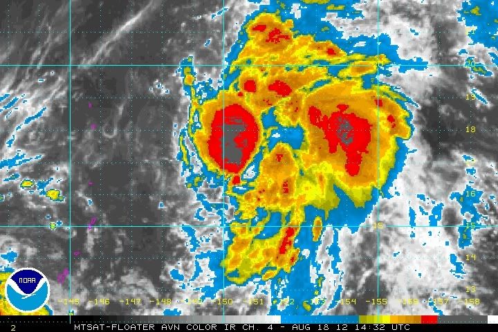
WPAC: INVEST 98W
Moderator: S2k Moderators
Re: WPAC: INVEST 98W
thanks RL3A0....
this popped out of nowhere and it looks like a tropical storm...dvorak estimates are just catching up...
0 likes
Remember, all of my post aren't official. For official warnings and discussions, Please refer to your local NWS products...
NWS for the Western Pacific
https://www.weather.gov/gum/
NWS for the Western Pacific
https://www.weather.gov/gum/
Re:
Meow wrote:96W, 97W, 98W... The northwestern Pacific in 2012 is crazy.
i don't know how long you've been following tropical cyclones but i've seen crazier things...
0 likes
Remember, all of my post aren't official. For official warnings and discussions, Please refer to your local NWS products...
NWS for the Western Pacific
https://www.weather.gov/gum/
NWS for the Western Pacific
https://www.weather.gov/gum/
Re:
Meow wrote:96W, 97W, 98W... The northwestern Pacific in 2012 is crazy.
This has been a fairly average season for the WPac. In terms of strong systems maybe even a bit below normal.
ACE of 91 so far with average this time of year being 104.
http://policlimate.com/tropical/
0 likes
-
- Category 5
- Posts: 3408
- Joined: Sat Oct 24, 2009 11:50 pm
Re: WPAC: INVEST 98W
^Also noticed that, we've only had 3 major typhoons so far with 1 being a supertyphoon. But there is still plenty of time to rake in more ACE. We don't know if we'll see major typhoons coming one after another in the last quarter of the year, like in 2006...
It seems that the system shown by models to develop sometime from Aug25-27 is either this or invest 97W.
0 likes
Personal Forecast Disclaimer:
The posts in this forum are NOT official forecast and should not be used as such. They are just the opinion of the poster and may or may not be backed by sound meteorological data. They are NOT endorsed by any professional institution or storm2k.org. For official information, please refer to the NHC and NWS products.
Re: WPAC: INVEST 98W
dexterlabio wrote:^Also noticed that, we've only had 3 major typhoons so far with 1 being a supertyphoon. But there is still plenty of time to rake in more ACE. We don't know if we'll see major typhoons coming one after another in the last quarter of the year, like in 2006...
It seems that the system shown by models to develop sometime from Aug25-27 is either this or invest 97W.
There has not been an intensive typhoon (≥105 knots) from the JMA yet this year.
0 likes
Re: WPAC: INVEST 98W
AN AREA OF CONVECTION HAS PERSISTED NEAR 16.7N 151.6E,
APPROXIMATELY 440 NM EAST-NORTHEAST OF GUAM. RECENT ANIMATED
ENHANCED INFRARED SATELLITE IMAGERY SHOWS AN AREA OF BROADLY
TURNING, BUILDING CONVECTION OVER WHAT SEEMS TO BE AN AREA OF TIGHT
TROUGHING, AS INDICATED BY THE 181149Z ASCAT AND 181404Z OSCAT
PASSES. CURRENT DATA SUGGESTS NO EVIDENCE OF A LOW-LEVEL CIRCULATION
CENTER (LLCC) BUT PERHAPS RATHER A VERY STRONG MID-LEVEL
CIRCULATION. UPPER-LEVEL ANALYSIS INDICATES THE DISTURBANCE IS
LOCATED A COUPLE OF DEGREES POLEWARD OF THE NEAR EQUATORIAL RIDGE
AXIS UNDER MODERATE (15-20 KNOTS) VERTICAL WIND SHEAR. ANIMATED
WATER VAPOR IMAGERY SHOWS ENHANCED EASTWARD OUTFLOW INTO A TROPICAL
UPPER-TROPOSPHERIC TROUGH CELL POSITIONED FURTHER EAST, WHILE
EQUATORWARD OUTFLOW REMAINS FAIR. SEA SURFACE TEMPERATURES ARE
FAVORABLE FOR TROPICAL CYCLONE DEVELOPMENT RANGING FROM 27-29
DEGREES CELSIUS. MAXIMUM SUSTAINED SURFACE WINDS ARE ESTIMATED AT 10
TO 15 KNOTS. MINIMUM SEA LEVEL PRESSURE IS ESTIMATED TO BE NEAR 1009
MB. DUE TO A LACK OF EVIDENCE SUPPORTING THE EXISTENCE OF A LLCC,
THE POTENTIAL FOR THE DEVELOPMENT OF A SIGNIFICANT TROPICAL CYCLONE
WITHIN THE NEXT 24 HOURS IS LOW.
0 likes
Remember, all of my post aren't official. For official warnings and discussions, Please refer to your local NWS products...
NWS for the Western Pacific
https://www.weather.gov/gum/
NWS for the Western Pacific
https://www.weather.gov/gum/
-
- Category 5
- Posts: 3408
- Joined: Sat Oct 24, 2009 11:50 pm
Re: WPAC: INVEST 98W
Meow wrote:There has not been an intensive typhoon (≥105 knots) from the JMA yet this year.
Guchol was a very intense typhoon according to JMA, and I think it peaked at 105kts on 10-min average, wasn't it? Though yeah, if you're gonna use the JMA data for the TC's so far this year, we're gonna get a lower ACE. To be "uniform" with the other basins, I think it's good to use JTWC data (1-min average) to compute the ACE just for the sake of comparison.
...this invest is looking healthy IMO. Aside from Tembin, models are showing 1 more TC to form late this week. Could this be it or the other invest 97W, or maybe both of them will develop...
0 likes
Personal Forecast Disclaimer:
The posts in this forum are NOT official forecast and should not be used as such. They are just the opinion of the poster and may or may not be backed by sound meteorological data. They are NOT endorsed by any professional institution or storm2k.org. For official information, please refer to the NHC and NWS products.
Re: WPAC: INVEST 98W
dexterlabio wrote:Meow wrote:There has not been an intensive typhoon (≥105 knots) from the JMA yet this year.
Guchol was a very intense typhoon according to JMA, and I think it peaked at 105kts on 10-min average, wasn't it? Though yeah, if you're gonna use the JMA data for the TC's so far this year, we're gonna get a lower ACE. To be "uniform" with the other basins, I think it's good to use JTWC data (1-min average) to compute the ACE just for the sake of comparison.
...this invest is looking healthy IMO. Aside from Tembin, models are showing 1 more TC to form late this week. Could this be it or the other invest 97W, or maybe both of them will develop...
97W is the one thats forecast to develop...although i must say that i wouldn't be surprised if this was at least a depression...maybe tropical storm...i've seen worser...
0 likes
Remember, all of my post aren't official. For official warnings and discussions, Please refer to your local NWS products...
NWS for the Western Pacific
https://www.weather.gov/gum/
NWS for the Western Pacific
https://www.weather.gov/gum/
Re: WPAC: INVEST 98W
THE AREA OF CONVECTION PREVIOUSLY LOCATED NEAR 19.2N
151.3E, IS NOW LOCATED NEAR 19.6N 151.8E, APPROXIMATELY 565 NM
NORTHEAST OF GUAM. RECENT ANIMATED EIR SHOWS AN AREA OF BROAD
TURNING WITH WEAKENING CONVECTION ALONG THE PERIPHERIES. IT APPEARS
TO BE A WEAK MID-LEVEL CIRCULATION WITH A POSSIBLE WEAK LLCC
BEGINNING TO DEVELOP AS DEPICTED IN EIR. UPPER-LEVEL ANALYSIS
INDICATES THE DISTURBANCE IS LOCATED A COUPLE OF DEGREES POLEWARD OF
THE NEAR EQUATORIAL RIDGE AXIS UNDER MODERATE (10 TO 15 KNOTS) VWS.
ANIMATED WATER VAPOR IMAGERY SHOWS ENHANCED EASTWARD OUTFLOW INTO A
TROPICAL UPPER TROPOSPHERIC TROUGH CELL POSITIONED FURTHER EAST,
WHILE EQUATORWARD OUTFLOW REMAINS FAIR. SSTS ARE FAVORABLE FOR
TROPICAL CYCLONE DEVELOPMENT RANGING FROM 27-29 DEGREES CELSIUS.
MODEL GUIDANCE IS INDICATING POSSIBLE DEVELOPMENT IN THE VICINITY OF
THE AREA FROM PARA 1.A.(1), AND THIS REGION COULD BE ABSORBED INTO
THAT DEVELOPING REGION. MAXIMUM SUSTAINED SURFACE WINDS ARE
ESTIMATED AT 10 TO 15 KNOTS. MINIMUM SEA LEVEL PRESSURE IS ESTIMATED
TO BE NEAR 1009 MB. THE POTENTIAL FOR THE DEVELOPMENT OF A
SIGNIFICANT TROPICAL CYCLONE WITHIN THE NEXT 24 HOURS REMAINS MEDIUM.
0 likes
Remember, all of my post aren't official. For official warnings and discussions, Please refer to your local NWS products...
NWS for the Western Pacific
https://www.weather.gov/gum/
NWS for the Western Pacific
https://www.weather.gov/gum/
Re: WPAC: INVEST 98W
it looks like 98W will get absorbed by 16W!
0 likes
Remember, all of my post aren't official. For official warnings and discussions, Please refer to your local NWS products...
NWS for the Western Pacific
https://www.weather.gov/gum/
NWS for the Western Pacific
https://www.weather.gov/gum/
Re: WPAC: INVEST 98W
euro6208 wrote:it looks like 98W will get absorbed by 16W!
Yes, Bolaven has absorbed 98W.
0 likes
Who is online
Users browsing this forum: No registered users and 2 guests