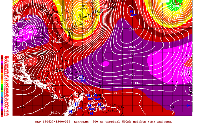
ATL: DEBBY - Post-Tropical

Moderator: S2k Moderators

Message
Author
User avatar
Rgv20
S2K Supporter
S2K Supporter
Posts: 2466
Age: 39
Joined: Wed Jan 05, 2011 5:42 pm
Location: Edinburg/McAllen Tx

Re: ATL: INVEST 96L - Discussion

#1701 Postby Rgv20 » Sat Jun 23, 2012 4:05 pm

Rgv20 wrote:
Ivanhater wrote:It will be interesting to see the first track...the NHC likes to follow the TVCN model (blend) which currently loops around Nola into the Florida Panhandle...we will see


I will be surprised if they used the TVCN, I'm more interested as to what they have to say about the GFS. Personally I would use a blend of the 12zECMWF, 12zUKMET, and 12zHWRF. But the safest bet is just showing Debby stationary south of LA for a couple of days and stress to the public that this is a very very low track forecast.


Yes I just quoted myself lol.....NHC kind of followed my thinking! :eek:
0 likes   
The following post is NOT an official forecast and should not be used as such. It is just the opinion of the poster and may or may not be backed by sound meteorological data. It is NOT endorsed by any professional institution including storm2k.org For Official Information please refer to the NHC and NWS products.

jlauderdal
S2K Supporter
S2K Supporter
Posts: 7184
Joined: Wed May 19, 2004 5:46 am
Location: NE Fort Lauderdale
Contact:

Re: ATL: INVEST 96L - Discussion

#1702 Postby jlauderdal » Sat Jun 23, 2012 4:05 pm

johngaltfla wrote:Wow. NHC went with the Euro model primarily. That was unexpected. :double:


miami nws office has been saying since yesterday that nhc(which is down the hall, literally) was favoring a westerly solution, this isn't a surprise at all
0 likes   

User avatar
johngaltfla
Category 5
Category 5
Posts: 2069
Joined: Sun Jul 10, 2005 9:17 pm
Location: Sarasota County, FL
Contact:

Re: ATL: INVEST 96L - Discussion

#1703 Postby johngaltfla » Sat Jun 23, 2012 4:05 pm

gatorcane wrote:
johngaltfla wrote:Wow. NHC went with the Euro model primarily. That was unexpected. :double:


Yes very unexpected. Also a very short discussion as expected from Avila. Would have thought they would not commit to west or east yet. It's rare the NHC goes completely against the GFS operational. Cant remember the last time they did that.


Me neither which sort of blows my mind. We may not have a good fix on the final direction until 0500 tomorrow when the shear lets up more.
0 likes   

AHS2011
Tropical Storm
Tropical Storm
Posts: 134
Joined: Sun Jun 05, 2011 7:39 am

Re: ATL: DEBBY-Tropical Storm

#1704 Postby AHS2011 » Sat Jun 23, 2012 4:05 pm

Expect a few changes from the NHC on the 11 P.M. E.S.T. update.
0 likes   
"People might not get all they work for in this world, but they must certainly work for all they get."- Frederick Douglass

User avatar
Dave
Retired Staff
Retired Staff
Posts: 13442
Age: 74
Joined: Tue Aug 01, 2006 3:57 pm
Location: Milan Indiana
Contact:

#1705 Postby Dave » Sat Jun 23, 2012 4:06 pm

Image
0 likes   
This post is NOT AN OFFICIAL FORECAST and should not be used as such. It is just the opinion of the poster and may or may not be backed by sound meteorological data. It is NOT endorsed by any professional institution including storm2k.org. For Official Information please refer to the NHC and NWS products.

User avatar
KWT
Category 5
Category 5
Posts: 31415
Joined: Tue Aug 17, 2004 11:02 am
Location: UK!!!

#1706 Postby KWT » Sat Jun 23, 2012 4:06 pm

In this case it really does seem likely to be one or the other. Its a tough one, early season systems tend to go further NE than expected and in this case any more N/NE motion will be enough to scoot it off to the ENE/NE, but if the ridge is strong enough and moves in fast enough then the system will get shunted westwards.

Could go either way yet IMO.
0 likes   
Personal Forecast Disclaimer:
The posts in this forum are NOT official forecast and should not be used as such. They are just the opinion of the poster and may or may not be backed by sound meteorological data. They are NOT endorsed by any professional institution or storm2k.org. For official information, please refer to the NHC and NWS products

Weatherfreak000

Re: ATL: DEBBY-Tropical Storm

#1707 Postby Weatherfreak000 » Sat Jun 23, 2012 4:06 pm

The NHC cone commonly changes significantly by about the third or fourth advisory. Nothing for certain here clearly a significant amount of uncertainity. All I got from that discussion was, "we are team euro".
0 likes   

User avatar
Kingarabian
S2K Supporter
S2K Supporter
Posts: 16004
Joined: Sat Aug 08, 2009 3:06 am
Location: Honolulu, Hawaii

#1708 Postby Kingarabian » Sat Jun 23, 2012 4:06 pm

Yeah I most def. think the NHC will back off from a sharp west forecast. Maybe a bit WNW?
0 likes   
RIP Kobe Bryant

User avatar
Hurricane Andrew
S2K Supporter
S2K Supporter
Posts: 1891
Age: 26
Joined: Sun May 23, 2010 2:53 pm
Location: KS

Re:

#1709 Postby Hurricane Andrew » Sat Jun 23, 2012 4:06 pm

Jevo wrote:I wouldn't say they went primarily with the EURO. The 12z HWRF has a similar solution.

And the UKIE
0 likes   

The Enthusiast
NREMT-AEMT, WX nerd

Irene '11, Sandy '12, Irma '17 (SAR)

"Hard to think we were born to live this way..." -Wage War

User avatar
Kingarabian
S2K Supporter
S2K Supporter
Posts: 16004
Joined: Sat Aug 08, 2009 3:06 am
Location: Honolulu, Hawaii

Re:

#1710 Postby Kingarabian » Sat Jun 23, 2012 4:08 pm

KWT wrote:In this case it really does seem likely to be one or the other. Its a tough one, early season systems tend to go further NE than expected and in this case any more N/NE motion will be enough to scoot it off to the ENE/NE, but if the ridge is strong enough and moves in fast enough then the system will get shunted westwards.

Could go either way yet IMO.

Good to see you KWT :D
0 likes   
RIP Kobe Bryant

User avatar
Dave
Retired Staff
Retired Staff
Posts: 13442
Age: 74
Joined: Tue Aug 01, 2006 3:57 pm
Location: Milan Indiana
Contact:

#1711 Postby Dave » Sat Jun 23, 2012 4:09 pm

000
URNT15 KNHC 232106
AF302 01AAA INVEST HDOB 33 20120623
205900 2807N 08519W 9630 00414 //// +211 //// 121038 039 024 003 01
205930 2806N 08520W 9630 00413 //// +210 //// 118037 038 022 004 01
210000 2805N 08521W 9631 00412 //// +209 //// 116037 038 023 005 01
210030 2804N 08522W 9631 00409 //// +210 //// 116036 038 023 004 01
210100 2803N 08524W 9628 00412 //// +208 //// 115036 038 023 003 01
210130 2802N 08525W 9630 00410 //// +208 //// 114037 038 023 004 01
210200 2800N 08527W 9631 00407 //// +207 //// 115037 038 024 006 01
210230 2759N 08528W 9631 00407 //// +202 //// 114037 038 025 007 01
210300 2758N 08529W 9629 00408 //// +204 //// 113036 037 025 006 01
210330 2757N 08531W 9627 00408 //// +204 //// 111039 041 023 005 01
210400 2756N 08532W 9630 00405 //// +208 //// 110040 041 022 006 01
210430 2755N 08533W 9629 00404 //// +212 //// 106039 040 024 005 01
210500 2754N 08535W 9631 00400 //// +210 //// 104040 041 023 003 01
210530 2752N 08536W 9630 00400 //// +211 //// 106041 041 026 001 01
210600 2751N 08537W 9631 00399 //// +209 //// 109041 041 022 004 01
210630 2750N 08539W 9627 00403 //// +206 //// 110041 042 024 005 01
210700 2749N 08540W 9630 00399 //// +207 //// 110043 044 026 003 01
210730 2748N 08541W 9630 00398 //// +206 //// 109041 043 028 003 01
210800 2747N 08543W 9631 00395 //// +205 //// 108042 043 030 004 01
210830 2745N 08544W 9440 00561 //// +194 //// 116045 046 032 002 05
$$
;
0 likes   

User avatar
Kingarabian
S2K Supporter
S2K Supporter
Posts: 16004
Joined: Sat Aug 08, 2009 3:06 am
Location: Honolulu, Hawaii

#1712 Postby Kingarabian » Sat Jun 23, 2012 4:09 pm

Pretty pathetic how CNN has NOTHING on this potential Hurricane threat.
0 likes   
RIP Kobe Bryant

User avatar
StormingB81
S2K Supporter
S2K Supporter
Posts: 5676
Age: 43
Joined: Thu Aug 27, 2009 1:45 am
Location: Rockledge, Florida

#1713 Postby StormingB81 » Sat Jun 23, 2012 4:10 pm

Wonder what will happen if this storm goes east what will everyone say
0 likes   

User avatar
Texas Snowman
Storm2k Moderator
Storm2k Moderator
Posts: 6179
Joined: Fri Jan 25, 2008 11:29 am
Location: Denison, Texas

Re: ATL: DEBBY-Tropical Storm

#1714 Postby Texas Snowman » Sat Jun 23, 2012 4:10 pm

AHS2011 wrote:Expect a few changes from the NHC on the 11 P.M. E.S.T. update.


We'll see. But I doubt it will be a pronounced difference from their current thinking (i.e. bring it back sharply to the east or northeast. If changes in forecast track thinking occur w/next few advisories, IMO, they will be gradual.
0 likes   
The above post and any post by Texas Snowman is NOT an official forecast and should not be used as such. It is just the opinion of the poster and may or may not be backed by sound meteorological data. It is NOT endorsed by any professional institution including storm2k.org. For official information, please refer to NWS products.

User avatar
TropicalAnalystwx13
Category 5
Category 5
Posts: 2109
Age: 28
Joined: Tue Jul 19, 2011 8:20 pm
Location: Wilmington, NC
Contact:

Re:

#1715 Postby TropicalAnalystwx13 » Sat Jun 23, 2012 4:10 pm

Kingarabian wrote:Yeah I most def. think the NHC will back off from a sharp west forecast. Maybe a bit WNW?

Storms don't barrel directly into high pressure areas. If anything, the storm will move west-southwest before landfall.
0 likes   

User avatar
ROCK
Category 5
Category 5
Posts: 9484
Age: 54
Joined: Tue Aug 17, 2004 7:30 am
Location: Kemah, Texas

Re:

#1716 Postby ROCK » Sat Jun 23, 2012 4:11 pm

Kingarabian wrote:The NHC follows the Euro Solution.

Image


hmmm....the NHC joins the EURO....I think that pretty much puts the GFS talk to rest.. :wink:

UKMET started the trend, CMC , NOGAPS, NAM, and then the EURO followed. When in doubt go with your biggest gun...
0 likes   

User avatar
KWT
Category 5
Category 5
Posts: 31415
Joined: Tue Aug 17, 2004 11:02 am
Location: UK!!!

#1717 Postby KWT » Sat Jun 23, 2012 4:11 pm

I think the west solution isn't without merit, the NHC must be looking at what the GFS based models are producing and thinking its doing its east bias thing.I think AFM had a great point earlier about the center getting tugged further NE though some models are expecting, I've seen the models get fooled many times by as much as 2-3 degrees within 24hrs, and in this case thats the difference between the western and eastern solution.

Super early 4th TS though!!
0 likes   
Personal Forecast Disclaimer:
The posts in this forum are NOT official forecast and should not be used as such. They are just the opinion of the poster and may or may not be backed by sound meteorological data. They are NOT endorsed by any professional institution or storm2k.org. For official information, please refer to the NHC and NWS products

User avatar
ROCK
Category 5
Category 5
Posts: 9484
Age: 54
Joined: Tue Aug 17, 2004 7:30 am
Location: Kemah, Texas

Re: ATL: DEBBY-Tropical Storm

#1718 Postby ROCK » Sat Jun 23, 2012 4:12 pm

AHS2011 wrote:Expect a few changes from the NHC on the 11 P.M. E.S.T. update.


care to tell us what those might be?
0 likes   

User avatar
Rgv20
S2K Supporter
S2K Supporter
Posts: 2466
Age: 39
Joined: Wed Jan 05, 2011 5:42 pm
Location: Edinburg/McAllen Tx

#1719 Postby Rgv20 » Sat Jun 23, 2012 4:12 pm

12zECMWF Ensemble Means is tightly clustered with the operational run of the Euro, maybe just a tad SW. I can see why the NHC went with the Euro as it is closing in at that 72hr mark in which it is really reliable.

Forecast Valid for Wednesday Morning (96hrs)
Image
0 likes   
The following post is NOT an official forecast and should not be used as such. It is just the opinion of the poster and may or may not be backed by sound meteorological data. It is NOT endorsed by any professional institution including storm2k.org For Official Information please refer to the NHC and NWS products.

User avatar
Texas Snowman
Storm2k Moderator
Storm2k Moderator
Posts: 6179
Joined: Fri Jan 25, 2008 11:29 am
Location: Denison, Texas

Re:

#1720 Postby Texas Snowman » Sat Jun 23, 2012 4:13 pm

Kingarabian wrote:Pretty pathetic how CNN has NOTHING on this potential Hurricane threat.


Well, for starters, Debby just officially formed. Plus it is the weekend. And while many of us here believe that there is a hurricane threat, the NHC forecast doesn't bring it to hurricane intensity all the way out to Thursday.

They're not going to over-react to a 50 mph tropical storm days from landfall.
0 likes   
The above post and any post by Texas Snowman is NOT an official forecast and should not be used as such. It is just the opinion of the poster and may or may not be backed by sound meteorological data. It is NOT endorsed by any professional institution including storm2k.org. For official information, please refer to NWS products.


Return to “2012”

Who is online

Users browsing this forum: No registered users and 1 guest