ATL: DEBBY - Post-Tropical

Moderator: S2k Moderators

Message
Author
User avatar
cycloneye
Admin
Admin
Posts: 145354
Age: 68
Joined: Thu Oct 10, 2002 10:54 am
Location: San Juan, Puerto Rico

Re:

#881 Postby cycloneye » Fri Jun 22, 2012 7:32 pm

NDG wrote:I still stand by my estimate.

http://i20.photobucket.com/albums/b245/ ... 546_an.gif


Do you agree with the 00z Best Track position?

233N 879W
0 likes   
Visit the Caribbean-Central America Weather Thread where you can find at first post web cams,radars
and observations from Caribbean basin members Click Here

User avatar
vaffie
Category 3
Category 3
Posts: 898
Joined: Sat Sep 11, 2004 5:11 pm
Location: Houston, Texas

Re: ATL: INVEST 96L - Models

#882 Postby vaffie » Fri Jun 22, 2012 7:35 pm

Weatherfreak000 wrote:Models backing away from development hmmmmm....
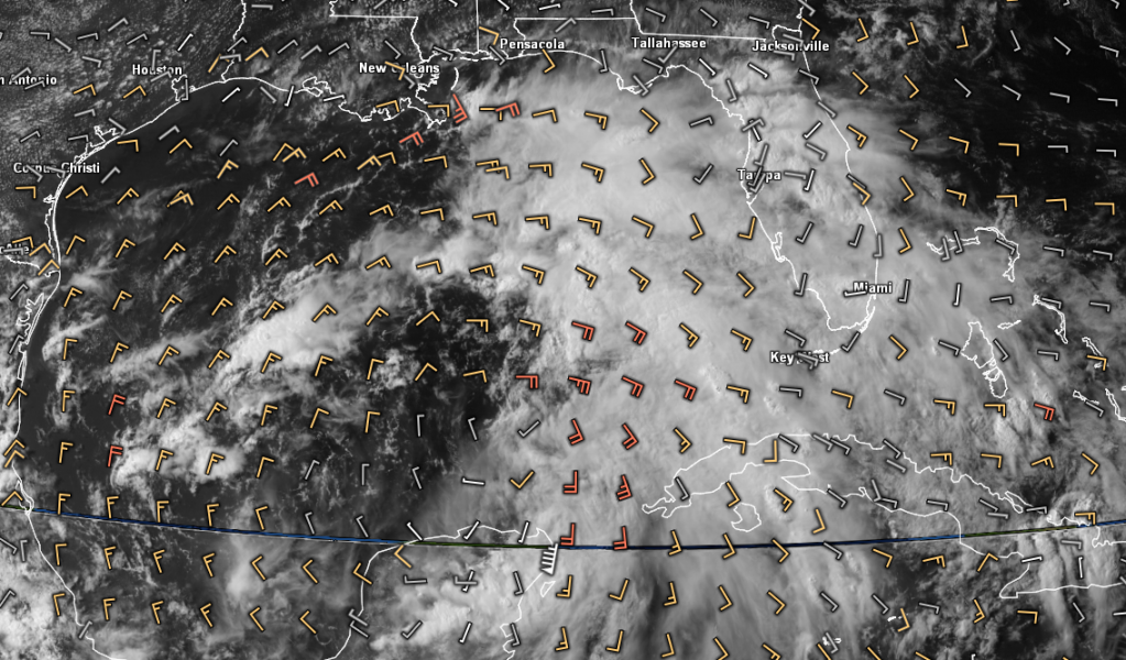

GFDL and HWRF are very bad at predicting strengthening storms until the storm reaches 1000 mb (weak tropical storm status), then they strengthen it. But even then, they're not the best if you ask me. Sometimes they go crazy and produce 900 mb storms, which only tells you that conditions are very favorable, because you hardly ever see those kinds of storms anyway. As for the GFS, maybe one out of three or four times does it ever show very intense storms, and typically only when they are already intense. It doesn't have the resolution, I think, which is why they're replacing it with the FIM model soon, which is a very high resolution model. Anyway, those are some thoughts of mine on the subject. In addition, NOGAPS, you may have observed, hardly ever shows significant intensification for any storm, and it's tracks are almost always into Mexico, it's too funny actually. And today is no exception.
0 likes   

User avatar
Rgv20
S2K Supporter
S2K Supporter
Posts: 2466
Age: 38
Joined: Wed Jan 05, 2011 5:42 pm
Location: Edinburg/McAllen Tx

#883 Postby Rgv20 » Fri Jun 22, 2012 7:38 pm

AL96, 233N 879W, 30kts, 1004mb, DB INVEST

Taking a close look at the Global Models from 12z the ECMWF, UKMET, and GFS verified nicely in regards to the position of the low. IMO tonight's GFS is going to flip to the West...
0 likes   
The following post is NOT an official forecast and should not be used as such. It is just the opinion of the poster and may or may not be backed by sound meteorological data. It is NOT endorsed by any professional institution including storm2k.org For Official Information please refer to the NHC and NWS products.

Air Force Met
Military Met
Military Met
Posts: 4372
Age: 56
Joined: Tue Jul 08, 2003 9:30 am
Location: Roan Mountain, TN

Re: Re:

#884 Postby Air Force Met » Fri Jun 22, 2012 7:39 pm

NDG wrote:
Hurricane Andrew wrote:If you look at the VIS loop, anyone think there is a low in the centerish of the convection, at about 22.8N 86W? It's messy down there.

http://www.ssd.noaa.gov/PS/TROP/floater ... short.html


Is not on the surface, that's a mid level vorticity.


Exactly. There are some on here looking at the mid level vort center and seeing the surface low. It aint so.

Bottom line is: THERE IS NO CENTER. There is NO LLC. There is just a broad low and the center of that low is somewhere near 23/24 and 87/88. Everything is rotating around that...including a nice little vortex that popped out from under the MLC that is fooling some people.

IT IS STILL A MESS. There is very little in the way of deep convection over water...and that means it will be at least tomorrow before another LLC can get going under deep convection...assuming it forms on the east side of the broad low (which I think it will).
0 likes   

User avatar
Hurricane Andrew
S2K Supporter
S2K Supporter
Posts: 1891
Age: 26
Joined: Sun May 23, 2010 2:53 pm
Location: KS

#885 Postby Hurricane Andrew » Fri Jun 22, 2012 7:40 pm

I'll take the 0z NAM posting.
0 likes   

The Enthusiast
NREMT-AEMT, WX nerd

Irene '11, Sandy '12, Irma '17 (SAR)

"Hard to think we were born to live this way..." -Wage War

User avatar
NDG
S2K Supporter
S2K Supporter
Posts: 15446
Joined: Sun Jul 09, 2006 10:14 pm
Location: Orlando, FL

Re: Re:

#886 Postby NDG » Fri Jun 22, 2012 7:41 pm

cycloneye wrote:
NDG wrote:I still stand by my estimate.

http://i20.photobucket.com/albums/b245/ ... 546_an.gif


Do you agree with the 00z Best Track position?

233N 879W


Earlier that is where I was tracking the broad COC, but as the evening has continued it appears that the possible LLC is becoming the COC.
0 likes   

User avatar
cycloneye
Admin
Admin
Posts: 145354
Age: 68
Joined: Thu Oct 10, 2002 10:54 am
Location: San Juan, Puerto Rico

Re: ATL: INVEST 96L - Discussion

#887 Postby cycloneye » Fri Jun 22, 2012 7:44 pm

Spreaking of Best Track for 96L,here are all the plots until the 00z one.

Image
0 likes   
Visit the Caribbean-Central America Weather Thread where you can find at first post web cams,radars
and observations from Caribbean basin members Click Here

User avatar
NDG
S2K Supporter
S2K Supporter
Posts: 15446
Joined: Sun Jul 09, 2006 10:14 pm
Location: Orlando, FL

Re: Re:

#888 Postby NDG » Fri Jun 22, 2012 7:45 pm

Hurricane Andrew wrote:
NDG wrote:I still stand by my estimate.

http://i20.photobucket.com/albums/b245/ ... 546_an.gif

Could I please have a link to that loop?


Here is the link, you have to create it where you want it centered and which satellites to use.

http://vortex.plymouth.edu/gini_sat.html
0 likes   

Aric Dunn
Category 5
Category 5
Posts: 21238
Age: 42
Joined: Sun Sep 19, 2004 9:58 pm
Location: Ready for the Chase.
Contact:

#889 Postby Aric Dunn » Fri Jun 22, 2012 7:45 pm

notice it said ne of the yp ...
0 likes   
Note: If I make a post that is brief. Please refer back to previous posts for the analysis or reasoning. I do not re-write/qoute what my initial post said each time.
If there is nothing before... then just ask :)

Space & Atmospheric Physicist, Embry-Riddle Aeronautical University,
I believe the sky is falling...

Aric Dunn
Category 5
Category 5
Posts: 21238
Age: 42
Joined: Sun Sep 19, 2004 9:58 pm
Location: Ready for the Chase.
Contact:

#890 Postby Aric Dunn » Fri Jun 22, 2012 7:47 pm

disregard that little eddy. keep focus on the convection sse of there.
0 likes   
Note: If I make a post that is brief. Please refer back to previous posts for the analysis or reasoning. I do not re-write/qoute what my initial post said each time.
If there is nothing before... then just ask :)

Space & Atmospheric Physicist, Embry-Riddle Aeronautical University,
I believe the sky is falling...

User avatar
ROCK
Category 5
Category 5
Posts: 9484
Age: 54
Joined: Tue Aug 17, 2004 7:30 am
Location: Kemah, Texas

Re:

#891 Postby ROCK » Fri Jun 22, 2012 7:48 pm

Rgv20 wrote:AL96, 233N 879W, 30kts, 1004mb, DB INVEST

Taking a close look at the Global Models from 12z the ECMWF, UKMET, and GFS verified nicely in regards to the position of the low. IMO tonight's GFS is going to flip to the West...


I agree...it doesnt really have a choice unless it wants to bust incredibly bad. Kudos to the UKMET (which I think was by accident) and the CMC for sniffing out this trend way before the others.
0 likes   

User avatar
tailgater
S2K Supporter
S2K Supporter
Posts: 3339
Joined: Sun Jul 11, 2004 9:13 pm
Location: St. Amant La.

Re: ATL: INVEST 96L - Discussion

#892 Postby tailgater » Fri Jun 22, 2012 7:49 pm

I agree with AFM but I do think it's getting pretty close, as it's not nearly as broad as it was this morning.
0 likes   
The following post is NOT an official forecast and should not be used as such. It is just the opinion of the poster and may or may not be backed by sound meteorological data. It is NOT endorsed by any professional institution including storm2k.org For Official Information please refer to the NHC and NWS products.

User avatar
Hurricane Andrew
S2K Supporter
S2K Supporter
Posts: 1891
Age: 26
Joined: Sun May 23, 2010 2:53 pm
Location: KS

Re: Re:

#893 Postby Hurricane Andrew » Fri Jun 22, 2012 7:49 pm

NDG wrote:
Hurricane Andrew wrote:
NDG wrote:I still stand by my estimate.

http://i20.photobucket.com/albums/b245/ ... 546_an.gif

Could I please have a link to that loop?


Here is the link, you have to create it where you want it centered and which satellites to use.

http://vortex.plymouth.edu/gini_sat.html

What settings do you use?
0 likes   

The Enthusiast
NREMT-AEMT, WX nerd

Irene '11, Sandy '12, Irma '17 (SAR)

"Hard to think we were born to live this way..." -Wage War

User avatar
robbielyn
Category 5
Category 5
Posts: 1298
Joined: Wed May 07, 2003 9:45 am
Location: brooksville, fl

Re: Re:

#894 Postby robbielyn » Fri Jun 22, 2012 7:50 pm

Air Force Met wrote:
NDG wrote:
Hurricane Andrew wrote:If you look at the VIS loop, anyone think there is a low in the centerish of the convection, at about 22.8N 86W? It's messy down there.

http://www.ssd.noaa.gov/PS/TROP/floater ... short.html


Is not on the surface, that's a mid level vorticity.


Exactly. There are some on here looking at the mid level vort center and seeing the surface low. It aint so.

Bottom line is: THERE IS NO CENTER. There is NO LLC. There is just a broad low and the center of that low is somewhere near 23/24 and 87/88. Everything is rotating around that...including a nice little vortex that popped out from under the MLC that is fooling some people.

IT IS STILL A MESS. There is very little in the way of deep convection ovehr water...and that means it will be at least tomorrow before another LLC can get going under deep convection...assuming it forms on the east side of the broad low (which I think it will).

In truth it shouldn't fool people cuz that swirl is moving too fast for it being a llc.
0 likes   
Robbielyn McCrary
I know just about enough to sound like I know what I'm talking about sometimes. But for your safety please follow the nhc for truly professional forecasting. :D

Aric Dunn
Category 5
Category 5
Posts: 21238
Age: 42
Joined: Sun Sep 19, 2004 9:58 pm
Location: Ready for the Chase.
Contact:

Re: Re:

#895 Postby Aric Dunn » Fri Jun 22, 2012 7:51 pm

Air Force Met wrote:
NDG wrote:
Hurricane Andrew wrote:If you look at the VIS loop, anyone think there is a low in the centerish of the convection, at about 22.8N 86W? It's messy down there.

http://www.ssd.noaa.gov/PS/TROP/floater ... short.html


Is not on the surface, that's a mid level vorticity.


Exactly. There are some on here looking at the mid level vort center and seeing the surface low. It aint so.

Bottom line is: THERE IS NO CENTER. There is NO LLC. There is just a broad low and the center of that low is somewhere near 23/24 and 87/88. Everything is rotating around that...including a nice little vortex that popped out from under the MLC that is fooling some people.

IT IS STILL A MESS. There is very little in the way of deep convection over water...and that means it will be at least tomorrow before another LLC can get going under deep convection...assuming it forms on the east side of the broad low (which I think it will).

its true there is no llc no organized center. there are however areas and things to pay attention to that many have alluded too.
0 likes   
Note: If I make a post that is brief. Please refer back to previous posts for the analysis or reasoning. I do not re-write/qoute what my initial post said each time.
If there is nothing before... then just ask :)

Space & Atmospheric Physicist, Embry-Riddle Aeronautical University,
I believe the sky is falling...

SunnyThoughts
Category 5
Category 5
Posts: 2263
Joined: Wed Jul 09, 2003 12:42 pm
Location: Pensacola, Florida

Re: ATL: INVEST 96L - Discussion

#896 Postby SunnyThoughts » Fri Jun 22, 2012 7:52 pm

What a hugeeee system

Image
0 likes   

crimi481
Category 2
Category 2
Posts: 602
Joined: Thu Sep 09, 2004 4:47 pm

Re: ATL: INVEST 96L - Discussion

#897 Postby crimi481 » Fri Jun 22, 2012 7:54 pm

Key West Radar loop
Impressive band approaching S.W. coast
http://radar.weather.gov/ridge/radar.ph ... x&loop=yes
0 likes   

User avatar
ROCK
Category 5
Category 5
Posts: 9484
Age: 54
Joined: Tue Aug 17, 2004 7:30 am
Location: Kemah, Texas

Re: ATL: INVEST 96L - Models

#898 Postby ROCK » Fri Jun 22, 2012 7:54 pm

0 likes   

User avatar
robbielyn
Category 5
Category 5
Posts: 1298
Joined: Wed May 07, 2003 9:45 am
Location: brooksville, fl

#899 Postby robbielyn » Fri Jun 22, 2012 7:57 pm

Brian Norcross says if it goes west it will be a stronger system than if it goes northeast towards fl. Here it will be a wet mess. Sheer will keep strengthening at bay as it gets in the northern Gulf.
0 likes   
Robbielyn McCrary
I know just about enough to sound like I know what I'm talking about sometimes. But for your safety please follow the nhc for truly professional forecasting. :D

User avatar
Hurricane Andrew
S2K Supporter
S2K Supporter
Posts: 1891
Age: 26
Joined: Sun May 23, 2010 2:53 pm
Location: KS

#900 Postby Hurricane Andrew » Fri Jun 22, 2012 7:58 pm

SREF
15z-87 hrs: 1003mb S of LA
21z-87hrs: 1002mb to the SW of the 15z position at 87hrs.
0 likes   

The Enthusiast
NREMT-AEMT, WX nerd

Irene '11, Sandy '12, Irma '17 (SAR)

"Hard to think we were born to live this way..." -Wage War


Return to “2012”

Who is online

Users browsing this forum: No registered users and 9 guests