ATL: DEBBY - Post-Tropical

Moderator: S2k Moderators

Message
Author
User avatar
vaffie
Category 3
Category 3
Posts: 898
Joined: Sat Sep 11, 2004 5:11 pm
Location: Houston, Texas

Re: ATL: INVEST 96L - Models

#461 Postby vaffie » Fri Jun 22, 2012 12:50 am


Interesting, but not surprising. I've noticed in the past that GFDL almost never strengthens non-depressions. It has to have an organized center before the GFDL recognizes it and shows how much it will strengthen. I wouldn't expect it to show anything much for another run or two. But if you watch the map and use your imagination, the lines are showing you where the center is, it has the same theme, of moving it towards NO/Mobile, then drifting westward. We will see if it pans out.
0 likes   

User avatar
ROCK
Category 5
Category 5
Posts: 9484
Age: 54
Joined: Tue Aug 17, 2004 7:30 am
Location: Kemah, Texas

Re: ATL: INVEST 96L - Models

#462 Postby ROCK » Fri Jun 22, 2012 12:53 am

so much for waiting up for the GFDL.... :lol:


next up EURO in 7 minutes....this should be telling...
0 likes   

User avatar
cycloneye
Admin
Admin
Posts: 145308
Age: 68
Joined: Thu Oct 10, 2002 10:54 am
Location: San Juan, Puerto Rico

Re: ATL: INVEST 96L - Models

#463 Postby cycloneye » Fri Jun 22, 2012 12:54 am

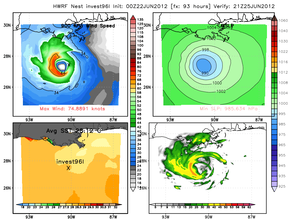
00z HWRF.

Image
0 likes   
Visit the Caribbean-Central America Weather Thread where you can find at first post web cams,radars
and observations from Caribbean basin members Click Here

Stratosphere747
Category 5
Category 5
Posts: 3772
Joined: Thu Sep 11, 2003 8:34 pm
Location: Surfside Beach/Freeport Tx
Contact:

Re: ATL: INVEST 96L - Models

#464 Postby Stratosphere747 » Fri Jun 22, 2012 12:55 am

0z HWRF at 93 and 126 hrs -

Image

Image
0 likes   

User avatar
ROCK
Category 5
Category 5
Posts: 9484
Age: 54
Joined: Tue Aug 17, 2004 7:30 am
Location: Kemah, Texas

Re: ATL: INVEST 96L - Models

#465 Postby ROCK » Fri Jun 22, 2012 12:56 am

similar to the CMC run.....takes it north meets ridge before landfall and shunts it west
0 likes   

User avatar
ROCK
Category 5
Category 5
Posts: 9484
Age: 54
Joined: Tue Aug 17, 2004 7:30 am
Location: Kemah, Texas

Re: ATL: INVEST 96L - Models

#466 Postby ROCK » Fri Jun 22, 2012 12:56 am

0 likes   

bella_may
Category 4
Category 4
Posts: 908
Joined: Wed Dec 22, 2010 2:13 pm
Location: SE Mississippi coast

Re: ATL: INVEST 96L - Models

#467 Postby bella_may » Fri Jun 22, 2012 12:58 am

oops the one i looked at wasnt updated. sorry. funny thing is our local met told us at 10 to not worry about this because all the models had it going to florida :lol:
0 likes   

User avatar
TeamPlayersBlue
Category 5
Category 5
Posts: 3445
Joined: Tue Feb 02, 2010 1:44 am
Location: Denver/Applewood, CO

Re: ATL: INVEST 96L - Discussion

#468 Postby TeamPlayersBlue » Fri Jun 22, 2012 12:59 am

ROCK wrote:I got a feeling this is going to have a large windfield due to the size.....like a WPAC system..

Kind of like Alex from 2010?
0 likes   
Personal Forecast Disclaimer:
The posts in this forum are NOT official forecast and should not be used as such. They are just the opinion of the poster and may or may not be backed by sound meteorological data. They are NOT endorsed by any professional institution or storm2k.org. For official information, please refer to the NHC and NWS products.

User avatar
Evil Jeremy
S2K Supporter
S2K Supporter
Posts: 5463
Age: 32
Joined: Mon Apr 10, 2006 2:10 pm
Location: Los Angeles, CA

#469 Postby Evil Jeremy » Fri Jun 22, 2012 1:02 am

EURO running. 48 hours out, splitting lows again, somewhat east of the previous run:

Image
0 likes   
Frances 04 / Jeanne 04 / Katrina 05 / Wilma 05 / Fay 08 / Debby 12 / Andrea 13 / Colin 16 / Hermine 16 / Matthew 16 / Irma 17

User avatar
ROCK
Category 5
Category 5
Posts: 9484
Age: 54
Joined: Tue Aug 17, 2004 7:30 am
Location: Kemah, Texas

Re: ATL: INVEST 96L - Models

#470 Postby ROCK » Fri Jun 22, 2012 1:03 am

0 likes   

User avatar
boca
Category 5
Category 5
Posts: 6367
Age: 60
Joined: Mon Dec 15, 2003 8:49 am
Location: Boca Raton,FL

Re: ATL: INVEST 96L - Models

#471 Postby boca » Fri Jun 22, 2012 1:04 am

I dont think this is going to to a Florida Peninsula problem anymore. That trough isn't strong enought to pick it up.Florida panhandle to Texas to watch more closely then Florida my reasoning is that high in the plains just might be strong enough to push this towards the La/TX area
0 likes   

User avatar
AJC3
Admin
Admin
Posts: 3999
Age: 61
Joined: Tue Aug 31, 2004 7:04 pm
Location: Ballston Spa, New York
Contact:

Re: ATL: INVEST 96L - Discussion

#472 Postby AJC3 » Fri Jun 22, 2012 1:06 am

vaffie wrote:
ROCK wrote:
vaffie wrote:Looking at the buoy data from the GOM, it seems that pressures are dropping at a fair rate (2.5 mb drop in the past 24 hours) and winds are rising quickly tonight. At this rate, by midday tomorrow the pressure will be sufficiently low enough to have continuous convection over the center and rapid strengthening will ensue.

Two buoys are as follows for instance:

http://www.ndbc.noaa.gov/show_plot.php? ... _label=CDT

http://www.ndbc.noaa.gov/show_plot.php? ... _label=CDT


where are these located?


Middle of the Gulf, fairly far away. Unfortunately there are no buoys in the southern Gulf... :(


http://www.ndbc.noaa.gov/station_page.php?station=42055
0 likes   

User avatar
ROCK
Category 5
Category 5
Posts: 9484
Age: 54
Joined: Tue Aug 17, 2004 7:30 am
Location: Kemah, Texas

Re: ATL: INVEST 96L - Models

#473 Postby ROCK » Fri Jun 22, 2012 1:06 am

Evil I will let you post....the run....
0 likes   

User avatar
boca
Category 5
Category 5
Posts: 6367
Age: 60
Joined: Mon Dec 15, 2003 8:49 am
Location: Boca Raton,FL

Re: ATL: INVEST 96L - Discussion

#474 Postby boca » Fri Jun 22, 2012 1:08 am

After staring at this for 2 minutes it looks like 96L is in the Yucatan Channel I see the most rotation there.

http://www.ssd.noaa.gov/goes/east/watl/flash-rb.html
0 likes   

User avatar
Evil Jeremy
S2K Supporter
S2K Supporter
Posts: 5463
Age: 32
Joined: Mon Apr 10, 2006 2:10 pm
Location: Los Angeles, CA

Re: ATL: INVEST 96L - Models

#475 Postby Evil Jeremy » Fri Jun 22, 2012 1:17 am

72 hours, consolidating in central Gulf:

Image

96 hours, not much change:

Image
Last edited by Evil Jeremy on Fri Jun 22, 2012 1:18 am, edited 1 time in total.
0 likes   
Frances 04 / Jeanne 04 / Katrina 05 / Wilma 05 / Fay 08 / Debby 12 / Andrea 13 / Colin 16 / Hermine 16 / Matthew 16 / Irma 17

bella_may
Category 4
Category 4
Posts: 908
Joined: Wed Dec 22, 2010 2:13 pm
Location: SE Mississippi coast

#476 Postby bella_may » Fri Jun 22, 2012 1:18 am

oh my, i hope this doesnt follow the gfs
0 likes   

User avatar
Sambucol
Tropical Storm
Tropical Storm
Posts: 223
Joined: Wed Jul 25, 2007 5:09 pm

Re: ATL: INVEST 96L - Models

#477 Postby Sambucol » Fri Jun 22, 2012 1:18 am


Where does it take in at?
0 likes   

User avatar
South Texas Storms
Professional-Met
Professional-Met
Posts: 4226
Joined: Thu Jun 24, 2010 12:28 am
Location: Houston, TX

Re: ATL: INVEST 96L - Models

#478 Postby South Texas Storms » Fri Jun 22, 2012 1:19 am

Looks like it misses the trough again this run. 96 hrs: http://raleighwx.americanwx.com/models/ ... SLP096.gif
0 likes   

User avatar
boca
Category 5
Category 5
Posts: 6367
Age: 60
Joined: Mon Dec 15, 2003 8:49 am
Location: Boca Raton,FL

Re: ATL: INVEST 96L - Models

#479 Postby boca » Fri Jun 22, 2012 1:20 am

0 likes   

User avatar
Evil Jeremy
S2K Supporter
S2K Supporter
Posts: 5463
Age: 32
Joined: Mon Apr 10, 2006 2:10 pm
Location: Los Angeles, CA

#480 Postby Evil Jeremy » Fri Jun 22, 2012 1:21 am

120 Hours, Texas bound:

Image
0 likes   
Frances 04 / Jeanne 04 / Katrina 05 / Wilma 05 / Fay 08 / Debby 12 / Andrea 13 / Colin 16 / Hermine 16 / Matthew 16 / Irma 17


Return to “2012”

Who is online

Users browsing this forum: Google [Bot] and 2 guests