Spaghetti plot? More like spaghetti bowl!
Would a GulfStream flight help out with the track? Since there is zero confidence now...
ATL: DEBBY - Post-Tropical
Moderator: S2k Moderators
-
Aric Dunn
- Category 5

- Posts: 21238
- Age: 43
- Joined: Sun Sep 19, 2004 9:58 pm
- Location: Ready for the Chase.
- Contact:
keep paying attentiin ne of the yucatan ... it will consolidate with the convection.
0 likes
Note: If I make a post that is brief. Please refer back to previous posts for the analysis or reasoning. I do not re-write/qoute what my initial post said each time.
If there is nothing before... then just ask
Space & Atmospheric Physicist, Embry-Riddle Aeronautical University,
I believe the sky is falling...
If there is nothing before... then just ask
Space & Atmospheric Physicist, Embry-Riddle Aeronautical University,
I believe the sky is falling...
-
StormingB81

- S2K Supporter

- Posts: 5676
- Age: 44
- Joined: Thu Aug 27, 2009 1:45 am
- Location: Rockledge, Florida
-
northjaxpro

- S2K Supporter
- Posts: 8900
- Joined: Mon Sep 27, 2010 11:21 am
- Location: Jacksonville, FL
Re:
Aric Dunn wrote:keep paying attentiin ne of the yucatan ... it will consolidate with the convection.
By this Aric are you seeing a relocation of the center under the deepest convection?
0 likes
NEVER, EVER SAY NEVER in the tropics and weather in general, and most importantly, with life itself!!
________________________________________________________________________________________
Fay 2008 Beryl 2012 Debby 2012 Colin 2016 Hermine 2016 Julia 2016 Matthew 2016 Irma 2017 Dorian 2019
________________________________________________________________________________________
Fay 2008 Beryl 2012 Debby 2012 Colin 2016 Hermine 2016 Julia 2016 Matthew 2016 Irma 2017 Dorian 2019
-
Rgv20

- S2K Supporter
- Posts: 2466
- Age: 39
- Joined: Wed Jan 05, 2011 5:42 pm
- Location: Edinburg/McAllen Tx
I took a look at the 12zECMWF&CMC Ensemble Means and they favor a western gulf coast storm.
First of all this is the 12zCMC Ensemble Means Forecast Valid for Tuesday Morning, all I have to say is WOW....The timing of this possible TC is almost identical as to this morning 12zUKMET. IMO this may be a little to fast..
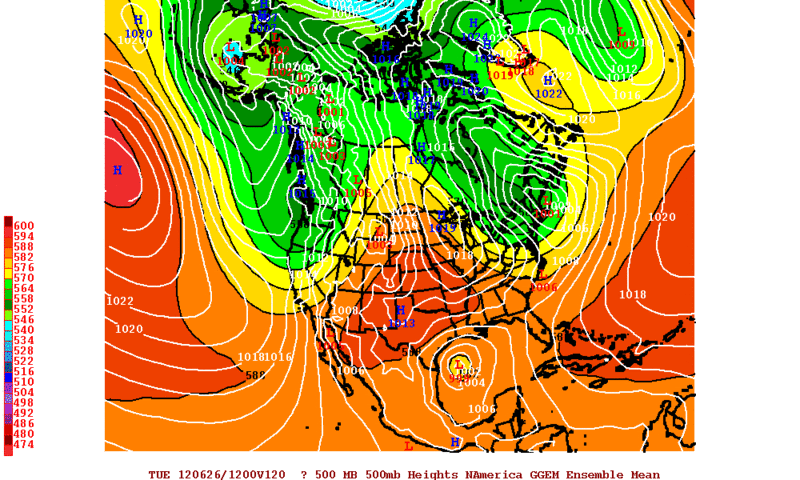
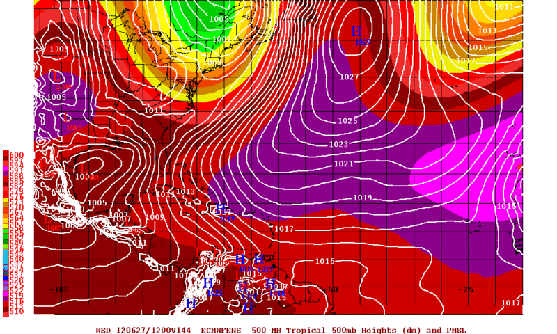
12zECMWF Ensemble Means favor a TC due east of Brownsville by Wednesday Morning, which is just to the WSW of the Operational Run of the ECMWF. If the ECMWF is going to keep the TC in Western GOM in future runs IMO it will trend to the South of this morning run.
First of all this is the 12zCMC Ensemble Means Forecast Valid for Tuesday Morning, all I have to say is WOW....The timing of this possible TC is almost identical as to this morning 12zUKMET. IMO this may be a little to fast..
12zECMWF Ensemble Means favor a TC due east of Brownsville by Wednesday Morning, which is just to the WSW of the Operational Run of the ECMWF. If the ECMWF is going to keep the TC in Western GOM in future runs IMO it will trend to the South of this morning run.
0 likes
The following post is NOT an official forecast and should not be used as such. It is just the opinion of the poster and may or may not be backed by sound meteorological data. It is NOT endorsed by any professional institution including storm2k.org For Official Information please refer to the NHC and NWS products.
-
bamajammer4eva
- Category 4

- Posts: 907
- Joined: Sun Apr 18, 2010 3:21 am
- Location: Ozark, AL
Re: ATL: INVEST 96L - Discussion
Tallahassee NWS just posted this graphic on their homepage saying that this should move West and away from Florida. They also put the models on there showing the 3 most reliable models moving it west with only 1 lonely model showing a FL Hit.


0 likes
-
CrazyC83
- Professional-Met

- Posts: 34316
- Joined: Tue Mar 07, 2006 11:57 pm
- Location: Deep South, for the first time!
ATL: INVEST 96L - Models
There is that huge trough up there...it is going to miss? or could it pick it up?
0 likes

Re:
CrazyC83 wrote:There is that huge trough up there...it is going to miss? or could it pick it up?
That is the quadrillion dollar question.
0 likes
I'm no expert, everything I say should be taken with a large amount of salt. I could easily be very, very wrong.
~Zanthe Go Coyotes~
~Zanthe Go Coyotes~
-
HouTXmetro

- Category 5
- Posts: 3949
- Joined: Sun Jun 13, 2004 6:00 pm
- Location: District of Columbia, USA
Re: ATL: INVEST 96L - Discussion
Convection is really waning. Would be something if things went poof tonight. LOL
0 likes
[Disclaimer: My Amateur Opinion, please defer to your local authorities or the NHC for Guidance.]
-
CYCLONE MIKE
- Category 5
- Posts: 2183
- Joined: Tue Aug 31, 2004 6:04 pm
- Location: Gonzales, LA
Re: ATL: INVEST 96L - Models
Got home from work to finally find an invest. What a surprise. Have noticed most models are starting to swing back more west with what if anything develops. Not buying into it yet as come tomorrow they could just as easily swing back east.  The GFS as usual seems to be over estimating the strength of the east coast trof. This is not some freak hurricane Charley scenario. Only way Florida would be a sure bet to get a visit from this is it explodes overnight into tomorrow and soory to say is not going to happen.
And as always this is my personal opinion not an official forecast. Just tracking these things for way to many years.
And as always this is my personal opinion not an official forecast. Just tracking these things for way to many years.
0 likes

As it should climatologically speaking this time of year. (westward). This in response to models from tallahasse not the post above me.
Last edited by robbielyn on Thu Jun 21, 2012 8:50 pm, edited 3 times in total.
0 likes
Robbielyn McCrary
I know just about enough to sound like I know what I'm talking about sometimes. But for your safety please follow the nhc for truly professional forecasting.
I know just about enough to sound like I know what I'm talking about sometimes. But for your safety please follow the nhc for truly professional forecasting.
-
ozonepete
- Professional-Met
- Posts: 4743
- Joined: Mon Sep 07, 2009 3:23 pm
- Location: From Ozone Park, NYC / Now in Brooklyn, NY
Re: Re:
northjaxpro wrote:Aric Dunn wrote:keep paying attentiin ne of the yucatan ... it will consolidate with the convection.
By this Aric are you seeing a relocation of the center under the deepest convection?
I always wind up saying it each new season and throughout the season: If you want to know where the COC, Center Of Circulation will wind up in a developing system, follow what Aric says. Nobody has a better eye for it. Having followed the way he looks at it and tried to get the same "eye" for it over the years, I totally agree that a center is slowly consolidating just northeast of the northeast tip of the Yucatan and due west of western Cuba. Watch the loops and you can see it.
0 likes
-
midnight8

- Tropical Depression

- Posts: 75
- Age: 52
- Joined: Sat Aug 14, 2010 3:05 pm
- Location: Orange, Texas
Re: ATL: INVEST 96L - Discussion
Local TV station here in Beaumont(KBMT-12) is playing up the possibility of a SE Texas landfall.
0 likes
KF5KWF Orange, Texas
-
MississippiHurricane

- ChatStaff

- Posts: 648
- Age: 41
- Joined: Sat Jul 16, 2005 12:20 am
- Location: Hanover, Maryland
- Contact:
Re: ATL: INVEST 96L - Models
I do wonder if the models are seeing this front that supposed to stall out and thus steering 96L away at a quick pace like that to the NE.
0 likes
Re: ATL: INVEST 96L - Discussion
HouTXmetro wrote:Convection is really waning. Would be something if things went poof tonight. LOL
I don't think it will be going poof. Died down for now at least...but flared up over land.
0 likes
I'm no expert, everything I say should be taken with a large amount of salt. I could easily be very, very wrong.
~Zanthe Go Coyotes~
~Zanthe Go Coyotes~
-
Hurricaneman

- Category 5
- Posts: 7404
- Age: 45
- Joined: Tue Aug 31, 2004 3:24 pm
- Location: central florida
Re: Re:
ozonepete wrote:northjaxpro wrote:Aric Dunn wrote:keep paying attentiin ne of the yucatan ... it will consolidate with the convection.
By this Aric are you seeing a relocation of the center under the deepest convection?
I always wind up saying it each new season and throughout the season: If you want to know where the COC, Center Of Circulation will wind up in a developing system, follow what Aric says. Nobody has a better eye for it. Having followed the way he looks at it and tried to get the same "eye" for it over the years, I totally agree that a center is slowly consolidating just northeast of the northeast tip of the Yucatan and due west of western Cuba. Watch the loops and you can see it.
This could change the outcome of the models, because they would be 200+ miles west if this relocation actually happens which would add another factor into the equation
The posts in this forum are NOT official forecast and should not be used as such. They are just the opinion of the poster and may or may not be backed by sound meteorological data. They are NOT endorsed by any professional institution or storm2k.org. For official information, please refer to the NHC and NWS products
0 likes

Re: ATL: INVEST 96L - Discussion
I disagree....I think that is the MLC as the cloud tops have warmed. The COC is inland and has been for most of today IMO....
http://rammb.cira.colostate.edu/ramsdis ... opical.asp
http://rammb.cira.colostate.edu/ramsdis ... opical.asp
0 likes
-
Jevo

- S2K Supporter
- Posts: 1729
- Age: 48
- Joined: Tue Aug 03, 2004 8:45 pm
- Location: The Flemish Cap
- Contact:
I do so love it when news stations predict landfall locations for storms that haven't formed yet. But with that being said I do believe that 96L does deserve the seal.

0 likes
Disclaimer: 50% of the time I have no clue of what I am talking about. Chances are I am taking a less than educated guess that sounds good because 10 years ago I stole Mike Watkins book 'The Hurricane and its Impact'. For official information please direct yourself to the NHC and their cadre of weather geniuses.
-
northjaxpro
- S2K Supporter
- Posts: 8900
- Joined: Mon Sep 27, 2010 11:21 am
- Location: Jacksonville, FL
Re: Re:
ozonepete wrote:northjaxpro wrote:Aric Dunn wrote:keep paying attentiin ne of the yucatan ... it will consolidate with the convection.
By this Aric are you seeing a relocation of the center under the deepest convection?
I always wind up saying it each new season and throughout the season: If you want to know where the COC, Center Of Circulation will wind up in a developing system, follow what Aric says. Nobody has a better eye for it. Having followed the way he looks at it and tried to get the same "eye" for it over the years, I totally agree that a center is slowly consolidating just northeast of the northeast tip of the Yucatan and due west of western Cuba. Watch the loops and you can see it.
Actually, I have watched the loop and it is definitely a possibility for a LLC to re-locate in that region off to just northeast of the NE tip of the Yucatan Peninsula. Initially, I thought it may have been a MLC there. However, convection has really waned both over the Yucatan and in the huge convective mass in the Yucatan Channel and SE Gulf in the past couple of hours.
0 likes
NEVER, EVER SAY NEVER in the tropics and weather in general, and most importantly, with life itself!!
________________________________________________________________________________________
Fay 2008 Beryl 2012 Debby 2012 Colin 2016 Hermine 2016 Julia 2016 Matthew 2016 Irma 2017 Dorian 2019
________________________________________________________________________________________
Fay 2008 Beryl 2012 Debby 2012 Colin 2016 Hermine 2016 Julia 2016 Matthew 2016 Irma 2017 Dorian 2019
-
wxman57

- Moderator-Pro Met

- Posts: 23177
- Age: 68
- Joined: Sat Jun 21, 2003 8:06 pm
- Location: Houston, TX (southwest)
Re: ATL: INVEST 96L - Discussion
Obs indicate a very broad low center, perhaps 150 miles across with a lobe near the Yucatan and another off to the NNE a good ways. Sort of like Frances of 1998.
0 likes
Who is online
Users browsing this forum: No registered users and 24 guests