
ATL: BERYL - Post-Tropical
Moderator: S2k Moderators
-
TropicalAnalystwx13

- Category 5

- Posts: 2109
- Age: 28
- Joined: Tue Jul 19, 2011 8:20 pm
- Location: Wilmington, NC
- Contact:
-
ocala
- Tropical Depression

- Posts: 88
- Joined: Sat Apr 08, 2006 8:48 am
- Location: Candler,Florida
- Contact:
Re: ATL: INVEST 94L
ozonepete wrote:Looks to be turning west now...
http://www.ssd.noaa.gov/PS/TROP/floater ... -long.html
Looking at a radar loop from Wilmington it certainly looks to be moving west.
0 likes
-
TropicalAnalystwx13
- Category 5
- Posts: 2109
- Age: 28
- Joined: Tue Jul 19, 2011 8:20 pm
- Location: Wilmington, NC
- Contact:

-
ozonepete
- Professional-Met

- Posts: 4743
- Joined: Mon Sep 07, 2009 3:23 pm
- Location: From Ozone Park, NYC / Now in Brooklyn, NY
Re: ATL:INVEST 94L-Special Tropical Weather Outlook-Near 100%
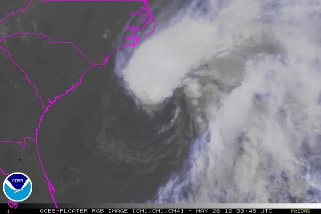
Wow. Convection to the north and west is not blowing away at all. Would indicate the shear is really dropping in that area, and we know shear is lower to the southwest. Just watching the satellite loops it looks to be developing much faster than I thought it would. (And of course it's moving over very warm water.)
0 likes
-
Dean4Storms
- S2K Supporter

- Posts: 6358
- Age: 63
- Joined: Sun Aug 31, 2003 1:01 pm
- Location: Miramar Bch. FL
Looks like it is becoming separated from the trough. This could really deepen tonight, lots of energy there.
http://www.ssd.noaa.gov/goes/east/nwatl/flash-vis.html
http://www.ssd.noaa.gov/goes/east/nwatl/flash-vis.html
0 likes
-
Hurricaneman

- Category 5
- Posts: 7404
- Age: 45
- Joined: Tue Aug 31, 2004 3:24 pm
- Location: central florida
Re:
TropicalAnalystwx13 wrote:http://i.imgur.com/BrZSr.png
If my eyes aren't decieving me the southeastern part of the circulation is still convection free, but the western part seems to be forming the very beginnings of an eyewall
The posts in this forum are NOT official forecast and should not be used as such. They are just the opinion of the poster and may or may not be backed by sound meteorological data. They are NOT endorsed by any professional institution or storm2k.org. For official information, please refer to the NHC and NWS products
0 likes
-
SunnyThoughts
- Category 5
- Posts: 2263
- Joined: Wed Jul 09, 2003 12:42 pm
- Location: Pensacola, Florida
-
Hurricaneman
- Category 5
- Posts: 7404
- Age: 45
- Joined: Tue Aug 31, 2004 3:24 pm
- Location: central florida
Re:
SunnyThoughts wrote:Certainly does look to be separating and becoming its own entity. LOTS of anticipation for recon tomorrow. Can't wait to see how strong the winds will be by then.
At the rate this is strengthening it could be a strong tropical storm ar cat 1 hurricane at peak
The posts in this forum are NOT official forecast and should not be used as such. They are just the opinion of the poster and may or may not be backed by sound meteorological data. They are NOT endorsed by any professional institution or storm2k.org. For official information, please refer to the NHC and NWS products
0 likes
-
'CaneFreak

- Category 5
- Posts: 1487
- Joined: Mon Jun 05, 2006 10:50 am
- Location: New Bern, NC
Re: Re:
Use of the term CDO would be more applicable here (central dense overcast)
Hurricaneman wrote:TropicalAnalystwx13 wrote:http://i.imgur.com/BrZSr.png
If my eyes aren't decieving me the southeastern part of the circulation is still convection free, but the western part seems to be forming the very beginnings of an eyewall
The posts in this forum are NOT official forecast and should not be used as such. They are just the opinion of the poster and may or may not be backed by sound meteorological data. They are NOT endorsed by any professional institution or storm2k.org. For official information, please refer to the NHC and NWS products
0 likes
-
ozonepete
- Professional-Met
- Posts: 4743
- Joined: Mon Sep 07, 2009 3:23 pm
- Location: From Ozone Park, NYC / Now in Brooklyn, NY
Re:
SunnyThoughts wrote:Certainly does look to be separating and becoming its own entity. LOTS of anticipation for recon tomorrow. Can't wait to see how strong the winds will be by then.
Yeah, look at this image. Considering how it already looks and the environment it's moving into this has high potential for a strong TS or maybe a cat 1. Not much to stop intensification if it goes on forecast track. What's impressive is that it is still ahead of the model forecasts in strength and track. I think the models had it at 1008 mb or so and it must be below 1004 now (hit that at 5PM I think).
0 likes
-
TropicalAnalystwx13
- Category 5
- Posts: 2109
- Age: 28
- Joined: Tue Jul 19, 2011 8:20 pm
- Location: Wilmington, NC
- Contact:
-
'CaneFreak
- Category 5
- Posts: 1487
- Joined: Mon Jun 05, 2006 10:50 am
- Location: New Bern, NC
Re:
I don't think they will update it at 11 pm. They will probably will wait for 5 am or 11 am before updating in order to continue to monitor trends. I mean, it ain't going nowhere fast 
Edit: They did renumber
Edit: They did renumber
TropicalAnalystwx13 wrote:A little worried there has been no renumber...
Last edited by 'CaneFreak on Fri May 25, 2012 8:54 pm, edited 2 times in total.
0 likes
-
cycloneye

- Admin

- Posts: 149843
- Age: 69
- Joined: Thu Oct 10, 2002 10:54 am
- Location: San Juan, Puerto Rico
Re: ATL: INVEST 94L
BEGIN
NHC_ATCF
invest_RENUMBER_al942012_al022012.ren
FSTDA
R
U
040
010
0000
201205260151
NONE
NOTIFY=ATRP
http://ftp.nhc.noaa.gov/atcf/tcweb/inve ... 022012.ren
NHC_ATCF
invest_RENUMBER_al942012_al022012.ren
FSTDA
R
U
040
010
0000
201205260151
NONE
NOTIFY=ATRP
http://ftp.nhc.noaa.gov/atcf/tcweb/inve ... 022012.ren
0 likes
Visit the Caribbean-Central America Weather Thread where you can find at first post web cams,radars
and observations from Caribbean basin members Click Here
and observations from Caribbean basin members Click Here

-
Hurricaneman
- Category 5
- Posts: 7404
- Age: 45
- Joined: Tue Aug 31, 2004 3:24 pm
- Location: central florida
Re:
TropicalAnalystwx13 wrote:A little worried there has been no renumber...
Maybe they're waiting for the first morning satellite images
Forget what I said above Just renumered
0 likes
-
Hurricaneman
- Category 5
- Posts: 7404
- Age: 45
- Joined: Tue Aug 31, 2004 3:24 pm
- Location: central florida
Re: ATL: INVEST 94L-Breaking News=94L is renumbered as AL02
Im going to take a guess here but I think the NHC will go with 55mph with a possibility of a hurricane with landfall near Jacksonville
The posts in this forum are NOT official forecast and should not be used as such. They are just the opinion of the poster and may or may not be backed by sound meteorological data. They are NOT endorsed by any professional institution or storm2k.org. For official information, please refer to the NHC and NWS products
The posts in this forum are NOT official forecast and should not be used as such. They are just the opinion of the poster and may or may not be backed by sound meteorological data. They are NOT endorsed by any professional institution or storm2k.org. For official information, please refer to the NHC and NWS products
0 likes
Re: ATL: INVEST 94L-Breaking News=94L is renumbered as AL02
Hurricaneman wrote:Im going to take a guess here but I think the NHC will go with 55mph with a possibility of a hurricane with landfall near Jacksonville
The posts in this forum are NOT official forecast and should not be used as such. They are just the opinion of the poster and may or may not be backed by sound meteorological data. They are NOT endorsed by any professional institution or storm2k.org. For official information, please refer to the NHC and NWS products
Never seen a NHC advisory with 55 mph they usually go straight to 60
0 likes
-
cycloneye
- Admin
- Posts: 149843
- Age: 69
- Joined: Thu Oct 10, 2002 10:54 am
- Location: San Juan, Puerto Rico
Re: ATL: INVEST 94L-Breaking News=94L is renumbered as AL02
00z Best Track as Beryl
2012052600, , BEST, 0, 323N, 749W, 40, 1001, LO, 34, NEQ, 120, 100, 0, 120, 1012, 130, 70, 0, 0, L, 0, , 0, 0, BERYL, M
http://ftp.nhc.noaa.gov/atcf/tcweb/inve ... 012.invest
2012052600, , BEST, 0, 323N, 749W, 40, 1001, LO, 34, NEQ, 120, 100, 0, 120, 1012, 130, 70, 0, 0, L, 0, , 0, 0, BERYL, M
http://ftp.nhc.noaa.gov/atcf/tcweb/inve ... 012.invest
0 likes
Visit the Caribbean-Central America Weather Thread where you can find at first post web cams,radars
and observations from Caribbean basin members Click Here
and observations from Caribbean basin members Click Here

Track will be interesting. I bet that since the ECMWF did so well in the same area with Alberto's track they will be leaning heavily with the ECMWF's track of landfall in NE FL.
The posts in this forum are NOT official forecast and should not be used as such. They are just the opinion of the poster and may or may not be backed by sound meteorological data. They are NOT endorsed by any professional institution or storm2k.org. For official information, please refer to the NHC and NWS products.
The posts in this forum are NOT official forecast and should not be used as such. They are just the opinion of the poster and may or may not be backed by sound meteorological data. They are NOT endorsed by any professional institution or storm2k.org. For official information, please refer to the NHC and NWS products.
0 likes
Re: ATL: INVEST 94L-Breaking News=94L is renumbered as AL02
Expecting NHC to issue Beryl with 45-50 MPH winds
0 likes
Who is online
Users browsing this forum: No registered users and 49 guests