ATL: BERYL - Post-Tropical
Moderator: S2k Moderators
-
ozonepete
- Professional-Met

- Posts: 4743
- Joined: Mon Sep 07, 2009 3:23 pm
- Location: From Ozone Park, NYC / Now in Brooklyn, NY
Re: ATL: INVEST 94L
Do you know what's, roughly, the time of the last position that can be used for the 00Z runs tonight? I'm sure going to be waiting anxiously for them tonight.
0 likes
-
tropicwatch

- Category 5

- Posts: 3427
- Age: 62
- Joined: Sat Jun 02, 2007 10:01 am
- Location: The Villages, Florida
- Contact:
Re: ATL: INVEST 94L
Kind of surprising that the models have a pretty good consensus about movement west. It is just a wait and see type of thing now. The wind shear was still pretty high as of 1500 UTC around 40 knots.
Tropicwatch
Tropicwatch
0 likes
-
ozonepete
- Professional-Met
- Posts: 4743
- Joined: Mon Sep 07, 2009 3:23 pm
- Location: From Ozone Park, NYC / Now in Brooklyn, NY
Re: ATL: INVEST 94L
panamatropicwatch wrote:Kind of surprising that the models have a pretty good consensus about movement west. It is just a wait and see type of thing now. The wind shear was still pretty high as of 1500 UTC around 40 knots.
Tropicwatch
Yeah, shear will drop off slowly. Like watching paint dry.
0 likes
-
wxman57

- Moderator-Pro Met

- Posts: 23177
- Age: 68
- Joined: Sat Jun 21, 2003 8:06 pm
- Location: Houston, TX (southwest)
Re: ATL: INVEST 94L
That circulation visible on satellite near 31N/75W looks mid level. LLC may be well west of there. But it should consolidate tonight. Looking like more of a GA/SC event than a FL impact, as most of the wind/rain will probably be north of the track.
0 likes

Re: ATL: INVEST 94L
Cat 1 at landall?
Strong high should turn this w to wsw in the coming days.
Strong high should turn this w to wsw in the coming days.
0 likes
-
ozonepete
- Professional-Met
- Posts: 4743
- Joined: Mon Sep 07, 2009 3:23 pm
- Location: From Ozone Park, NYC / Now in Brooklyn, NY
Re: ATL: INVEST 94L
wxman57 wrote:That circulation visible on satellite near 31N/75W looks mid level. LLC may be well west of there. But it should consolidate tonight. Looking like more of a GA/SC event than a FL impact, as most of the wind/rain will probably be north of the track.
Wxman, look at the RGB loop and you'll see there's a distinct LLC there.
Your points about the wind/rain are well taken for this type of scenario.
0 likes
-
ozonepete
- Professional-Met
- Posts: 4743
- Joined: Mon Sep 07, 2009 3:23 pm
- Location: From Ozone Park, NYC / Now in Brooklyn, NY
Re:
FutureEM wrote:Perhaps somebody here can answer my question. If 94L froms into cyclone, is it possible that it could remain subtropical? The shear is going to weaken some, but might there still be enough to stop it from becoming fully tropical?
Not likely. The factors that are currently contributing to its subtropical characteristics should be gone by the time it landfalls.
0 likes

Re: ATL: INVEST 94L
Dry Air - the perinimal enemy of complete CDO formation (always a factor in time) - covers all points West of this system.
Anyone have info on how dry air here will be in few days?
WV Loop:
http://www.ssd.noaa.gov/goes/east/eaus/flash-wv.html
Anyone have info on how dry air here will be in few days?
WV Loop:
http://www.ssd.noaa.gov/goes/east/eaus/flash-wv.html
0 likes

Re: ATL: INVEST 94L
ozonepete wrote:wxman57 wrote:That circulation visible on satellite near 31N/75W looks mid level. LLC may be well west of there. But it should consolidate tonight. Looking like more of a GA/SC event than a FL impact, as most of the wind/rain will probably be north of the track.
Wxman, look at the RGB loop and you'll see there's a distinct LLC there.
Your points about the wind/rain are well taken for this type of scenario.
I agree with you regarding the LLC, very distinct on sat loop, very slowly moving north, so it could be the real COC setting up now.
0 likes
-
Aric Dunn
- Category 5
- Posts: 21238
- Age: 43
- Joined: Sun Sep 19, 2004 9:58 pm
- Location: Ready for the Chase.
- Contact:
latest sat. seems its already beginning to wobble around.
0 likes
Note: If I make a post that is brief. Please refer back to previous posts for the analysis or reasoning. I do not re-write/qoute what my initial post said each time.
If there is nothing before... then just ask
Space & Atmospheric Physicist, Embry-Riddle Aeronautical University,
I believe the sky is falling...
If there is nothing before... then just ask
Space & Atmospheric Physicist, Embry-Riddle Aeronautical University,
I believe the sky is falling...
-
ozonepete
- Professional-Met
- Posts: 4743
- Joined: Mon Sep 07, 2009 3:23 pm
- Location: From Ozone Park, NYC / Now in Brooklyn, NY
Re: ATL: INVEST 94L
crimi481 wrote:Dry Air - the perinimal enemy of complete CDO formation (always a factor in time) - covers all points West of this system.
Anyone have info on how dry air here will be in few days?
WV Loop:
http://www.ssd.noaa.gov/goes/east/eaus/flash-wv.html
GFS and other models have 700mb RH moistening up nicely by Sunday morning and beyond. Here's the GFS 4-panel. Scroll ahead to see different times and follow the lower left panel which shows 700 mb RH. So it doesn't appear it will be a factor after tomorrow. But that is a good question and that factor ALWAYS needs to be watched closely for precisely the reason you said.
Sorry, here's the link:
http://www.meteo.psu.edu/~gadomski/AVN_ ... opnew.html
0 likes
Re: ATL: INVEST 94L
Looks like a FLA landfall as a possible CAT 1. Who would have thought this as I look ay my calender.
off topic: God bless our vets!!
off topic: God bless our vets!!
0 likes
-
ozonepete
- Professional-Met
- Posts: 4743
- Joined: Mon Sep 07, 2009 3:23 pm
- Location: From Ozone Park, NYC / Now in Brooklyn, NY
Re:
Aric Dunn wrote:latest sat. seems its already beginning to wobble around.
I see that too. Looks like a counter-clockwise turn starting. Still a LOT of shear though. Could be a naked or semi-naked swirl for quite a while, probably until tomorrow.
0 likes
-
Chickenzilla
- Tropical Storm

- Posts: 109
- Joined: Wed Oct 19, 2011 7:31 am
- Location: Croatia (Southeast Europe)
Re: ATL: INVEST 94L
The circulation center is quite visible on the satellite images.It's exposed,tho.

BTW,94L is code red at the NHC site.
This post is NOT official forecast and should not be used as such. It is just the opinion of the poster and may or may not be backed by sound meteorological data. It is NOT endorsed by any professional institution or storm2k.org. For official information, please refer to the NHC and NWS products.
0 likes
Re: ATL: INVEST 94L
Thank for that link!! - (for Moisture content)
Didn't we end last Season like this- with strange Trop Systems? (last 2 years)
Any system that came near Gulf (and was forecast to strenghthen in 24 hrs) ended up "shredded".
Seemed like NHC (and most of us) had no reasons for Model predictions to be so far off.
Oh well - weather Worldwide has been nuts as well. (sorry - off track)
0 likes
-
Evil Jeremy

- S2K Supporter

- Posts: 5463
- Age: 32
- Joined: Mon Apr 10, 2006 2:10 pm
- Location: Los Angeles, CA
000
ABNT20 KNHC 251856
TWOAT
SPECIAL TROPICAL WEATHER OUTLOOK
NWS NATIONAL HURRICANE CENTER MIAMI FL
255 PM EDT FRI MAY 25 2012
FOR THE NORTH ATLANTIC...CARIBBEAN SEA AND THE GULF OF MEXICO...
A BROAD AREA OF LOW PRESSURE...CENTERED ABOUT 275 MILES SOUTHEAST OF
THE COAST OF THE CAROLINAS...IS PRODUCING WINDS TO GALE FORCE
MAINLY TO THE NORTHEAST AND SOUTHEAST OF THE CENTER. THE LOW HAS
BECOME A LITTLE BETTER DEFINED THIS AFTERNOON...ALTHOUGH THE
ASSOCIATED SHOWER AND THUNDERSTORM ACTIVITY REMAINS POORLY
ORGANIZED DUE TO STRONG UPPER-LEVEL WINDS. ENVIRONMENTAL
CONDITIONS ARE EXPECTED TO BECOME MORE CONDUCIVE FOR DEVELOPMENT ON
SATURDAY OR SUNDAY...AND THIS SYSTEM HAS A HIGH CHANCE...80
PERCENT...OF BECOMING A TROPICAL OR SUBTROPICAL CYCLONE DURING THE
NEXT 48 HOURS. LITTLE MOTION IS EXPECTED TODAY...BUT A
WEST-SOUTHWESTWARD OR SOUTHWESTWARD MOTION SHOULD BEGIN TOMORROW
AND CONTINUE THROUGH SUNDAY. COASTAL INTERESTS FROM THE CAROLINAS
SOUTHWARD THROUGH NORTHEASTERN FLORIDA SHOULD MONITOR THE PROGRESS
OF THIS SYSTEM OVER THE MEMORIAL DAY WEEKEND. IN ADDITION...LOCALLY
HEAVY RAINFALL...FLOODING...AND GUSTY WINDS WILL CONTINUE TODAY
OVER PORTIONS OF CENTRAL CUBA AND THE BAHAMAS. ANOTHER SPECIAL
TROPICAL WEATHER OUTLOOK WILL BE ISSUED TOMORROW...OR EARLIER IF
NECESSARY. FOR ADDITIONAL INFORMATION ON THIS SYSTEM...PLEASE SEE
HIGH SEAS FORECASTS ISSUED BY THE NATIONAL WEATHER SERVICE...AND
PRODUCTS FROM YOUR LOCAL WEATHER OFFICE.
ELSEWHERE...TROPICAL CYCLONE FORMATION IS NOT EXPECTED DURING THE
NEXT 48 HOURS.
&&
HIGH SEAS FORECASTS ISSUED BY THE NATIONAL WEATHER SERVICE CAN BE
FOUND UNDER AWIPS HEADER NFDHSFAT1 AND WMO HEADER FZNT01 KWBC.
$$
FORECASTER FRANKLIN
0 likes
Frances 04 / Jeanne 04 / Katrina 05 / Wilma 05 / Fay 08 / Debby 12 / Andrea 13 / Colin 16 / Hermine 16 / Matthew 16 / Irma 17
-
TropicalAnalystwx13

- Category 5
- Posts: 2109
- Age: 28
- Joined: Tue Jul 19, 2011 8:20 pm
- Location: Wilmington, NC
- Contact:
The posts in this forum are NOT official forecast and should not be used as such. They are just the opinion of the poster and may or may not be backed by sound meteorological data. They are NOT endorsed by any professional institution or storm2k.org. For official information, please refer to the NHC and NWS products.[/QUOTE]
I believe the system will be upgraded to Tropical Storm Beryl tomorrow afternoon after recon investigates. By then, it should be fully stacked with the upper level disturbance/low to its northwest and should be in a low wind shear environment. Gradual strengthening is expected tomorrow and tomorrow night, followed by slow weakening as the system approaches the FL/GA border due to the effects of the shelf waters. At this time, I am forecasting a peak intensity of 60 knots--give or take 5 mph. If 94L tries enough, it could briefly become a hurricane. Overall, the environment is more conducive than with Alberto, so a 60 mph+ peak is definitely likely.
0 likes
-
Aric Dunn
- Category 5
- Posts: 21238
- Age: 43
- Joined: Sun Sep 19, 2004 9:58 pm
- Location: Ready for the Chase.
- Contact:
Re: ATL:INVEST 94L:Special Tropical Weather Outlook=Code Red-80%
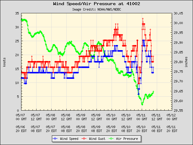
Pressure still falling rapidly at the buoy.
down to 1009 mb and falling. the center should pass over or near it this afternoon. The center there is probably about 50 to 75 miles away from that bouy. estimate the central pressure is 1006 or 7
down to 1009 mb and falling. the center should pass over or near it this afternoon. The center there is probably about 50 to 75 miles away from that bouy. estimate the central pressure is 1006 or 7
0 likes
Note: If I make a post that is brief. Please refer back to previous posts for the analysis or reasoning. I do not re-write/qoute what my initial post said each time.
If there is nothing before... then just ask
Space & Atmospheric Physicist, Embry-Riddle Aeronautical University,
I believe the sky is falling...
If there is nothing before... then just ask
Space & Atmospheric Physicist, Embry-Riddle Aeronautical University,
I believe the sky is falling...
Who is online
Users browsing this forum: No registered users and 5 guests